A Technological Leap: Sentinel-1C’s Advanced Capabilities
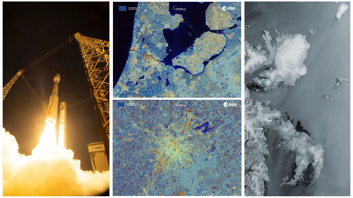
Launched on December 5, 2024, aboard a Vega-C rocket from Europe's Spaceport in French Guiana, the Copernicus Sentinel-1C satellite wasted no time proving its capabilities. Equipped with a state-of-the-art C-band synthetic aperture radar (SAR), it captured its first Earth images just 56 hours and 23 minutes after liftoff. These images underscore Sentinel-1C’s readiness to enhance critical global applications, from tracking environmental changes to supporting disaster response efforts.
First Images: A Glimpse of Sentinel-1C’s Potential
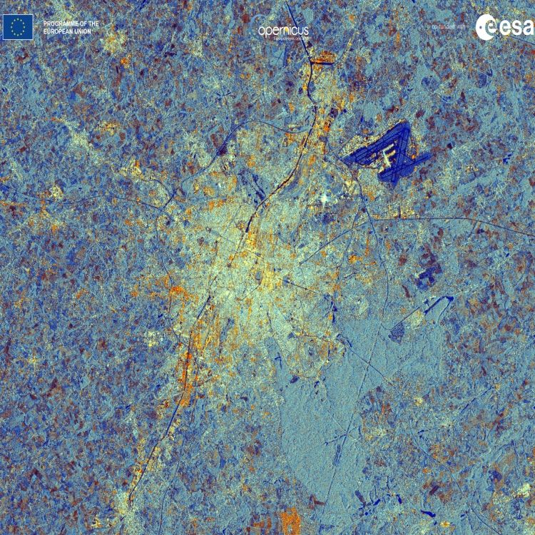
Svalbard, Arctic Ocean
Sentinel-1C’s inaugural image features Svalbard, a Norwegian archipelago in the Arctic Ocean. This region plays a vital role in monitoring ice coverage and understanding the impact of climate change on fragile polar ecosystems. The data from Sentinel-1C will also enhance navigation safety in Arctic waters, a key priority as ice conditions evolve.
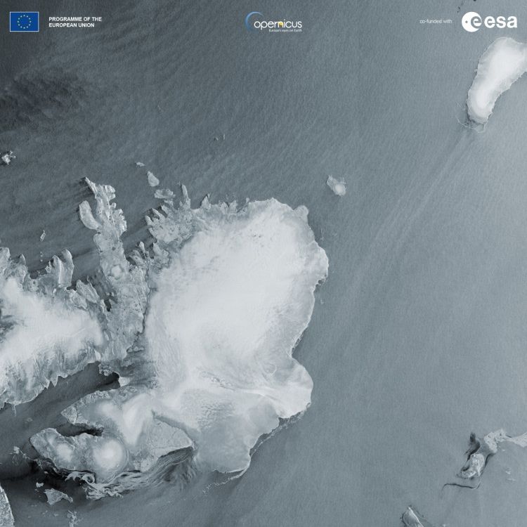
Amsterdam and Flevoland, Netherlands
Another striking image highlights Amsterdam and Flevoland, areas renowned for advanced water management and sustainable agriculture. Sentinel-1C’s radar data enables precise monitoring of soil moisture and crop health, supporting sustainable farming practices. Interestingly, this image reflects the legacy of the 1991 ERS mission, which also captured Flevoland in Europe’s first radar image.
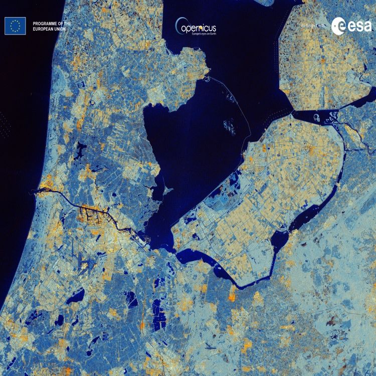
Brussels, Belgium
A vivid image of Brussels showcases the urban landscape in bright tones of white and yellow, contrasted with darker areas representing waterways and low-reflective surfaces like airport runways. Brussels holds historical significance, having appeared in the first radar image captured by Sentinel-1A in 2014.
A Legacy of Excellence: Sentinel-1C’s Role in the Copernicus Program
The high-resolution radar data provided by Sentinel-1C continues the legacy of its predecessors in the Copernicus program. Its free, publicly accessible data has wide-ranging applications, including:
- Arctic sea-ice monitoring to track environmental changes,
- Disaster response for natural hazards like earthquakes and floods,
- Maritime security to enhance safety at sea.
As part of the Copernicus constellation, Sentinel-1C ensures the seamless continuity of critical Earth observation data. This includes monitoring ground deformation after natural disasters, assessing forest health, and supporting humanitarian relief operations. Its data is freely available through the Copernicus Data Space Ecosystem, empowering researchers, policymakers, and industries worldwide.
Sentinel-1C: Supporting Sustainability and Innovation
With its commissioning phase underway, Sentinel-1C is poised to significantly advance the capabilities of the Sentinel-1 mission. By delivering reliable, high-quality data, it will support global efforts to achieve environmental sustainability and address pressing challenges like climate change.
The Sentinel-1C satellite not only reaffirms Europe’s leadership in Earth observation but also ensures that critical environmental data remains accessible to all. Its powerful radar technology and broad applications make it an indispensable tool for the modern world.