🌍 Capture the world at 100% OFF! Use code ongeo100on 10 meters satellite image resolutions – limited time only! Higher resolution satellite images remain subject to payment.
🌍 Capture the world at 100% OFF! Use code ongeo100on 10 meters satellite image resolutions – limited time only! Higher resolution satellite images remain subject to payment.
Biebrza National Park Fire 2025: Scale of Destruction and Recovery Efforts
2025-04-24
(Article updated:
2025-04-24
)
~ 6 min
In April 2025, Biebrza National Park, Poland’s largest national park and a critical haven for biodiversity, was engulfed by a devastating wildfire. This fire, the third in the park this year, scorched approximately over 200 hectares of protected land, threatening its unique ecosystems. Fueled by prolonged drought and exacerbated by human activities, the blaze posed significant challenges to firefighting efforts. However, timely rainfall and coordinated response from multiple agencies helped contain the fire, sparing the park’s most ecologically significant area, the Czerwone Bagno strict reserve. This article explores the fire’s impact, the response efforts, and insights from satellite imagery provided by OnGeo Intelligence, which revealed the extent of the destruction.
High-Quality Satellite Imagery, Hassle-Free
Explore any location on Earth with precision. Order a detailed Satellite Imagery Report—no sign-ups, no contracts. Delivered in a clear PDF for instant insights.
The fire broke out on Sunday, April 20, 2025, at 2:31 PM, with the State Fire Service receiving reports of burning dry grasslands and reed beds in the park. The blaze, centered at the border of Augustów and Mońki counties, rapidly spread across 200 hectares, with a fire front stretching 1.9 kilometers. The park’s highly flammable trzcinowiska (reed beds) and turzycowiska (sedge meadows), dried out by severe drought, fueled the fire’s intensity. By Monday, the fire had reached forested areas, complicating containment efforts due to the park’s marshy, inaccessible terrain.
This was the third fire in Biebrza National Park in 2025. Three weeks earlier, on March 30, a fire consumed nearly 90 hectares of reed beds and grasslands near Krasnybór and Kamienna Nowa. Another smaller fire, affecting 8–9 hectares, occurred days before the April blaze. These incidents pale in comparison to the park’s largest recorded fire in 2020, which devastated 5,300 hectares, but the 2025 fires underscore the growing threat of wildfires driven by climate change and drought.
Environmental Context: A Region Gripped by Drought
The 2025 fire was exacerbated by severe hydrological and meteorological conditions in Podlasie. Unlike the park’s typical spring floods, water levels in the Biebrza River dropped by 30 cm, transforming wetlands into tinderboxes. Since 2021, annual precipitation has steadily declined, with minimal rainfall in the autumn of 2024 and a snowless winter. These conditions left the park’s peatlands and grasslands critically dry, increasing fire risk. Experts note that the region’s groundwater levels fell to 0.6 meters below the surface in March, further drying out peatlands critical for water retention and biodiversity.
The absence of spring inundations, which normally sustain the park’s wetlands, has turned lush habitats into dry, steppe-like landscapes. This drying trend threatens not only the park’s flora but also its fauna, including rare bird species like the aquatic warbler, corncrake, and Eurasian curlew, which rely on wet habitats for breeding.
Response and Containment Efforts
The response to the fire was swift and multifaceted, involving 346 personnel, including firefighters from the State Fire Service (PSP) and Volunteer Fire Service (OSP), soldiers from the 1st Podlasie Territorial Defense Brigade, park staff, and foresters. Five helicopters, including a police Black Hawk equipped with a 3,000-liter Bambi Bucket, and a Dromader firefighting plane conducted over 250 water drops, delivering 344,000 liters of water. Five drone teams provided real-time monitoring, while specialized vehicles like Sherps and quads navigated the park’s rugged terrain.
A crisis management team, established by Podlasie Voivode on April 20, coordinated efforts. Prime Minister and Minister of Internal Affairs visited the site on April 21, emphasizing the national significance of protecting Biebrza’s ecosystems. By April 23, Minister of Climate and Environment announced that the fire was under control, aided by long-awaited rainfall. However, smoldering peatlands continued to pose challenges, requiring ongoing suppression efforts.
The fire did not reach the Czerwone Bagno strict reserve, a critical refuge for rare flora and fauna. This limited damage was a significant relief for conservationists, as Czerwone Bagno is one of Europe’s most unique forest ecosystems.
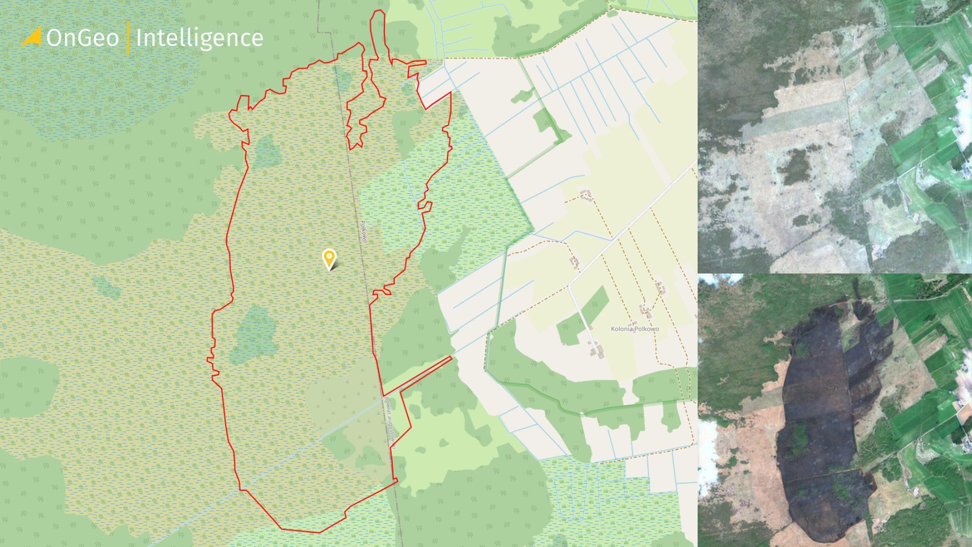
OnGeo Intelligence Satellite Imagery Report
OnGeo Intelligence’s satellite imagery provided critical insights into the fire’s impact. The imagery, analyzed post-fire, revealed that the blaze affected 200 hectares of reed beds, grasslands, and some forested areas, primarily in the park’s northern region. The report confirmed that the fire was largely surface-level, sparing deeper peat layers, which are vital for the park’s long-term ecological health. This aligns with ground assessments indicating that the fire did not cause widespread subsurface peat burning, which would have led to prolonged smoldering and greater carbon emissions.
The satellite data highlighted the fire’s proximity to Czerwone Bagno, with only peripheral damage to the reserve. Burn scars were most pronounced in trzcinowiska and turzycowiska, key habitats for endangered bird species like the ruff and common snipe. The imagery also underscored the role of drought in amplifying the fire’s spread, showing extensive dry patches where wetlands once thrived. These findings will guide restoration efforts, focusing on rehydration and habitat recovery.
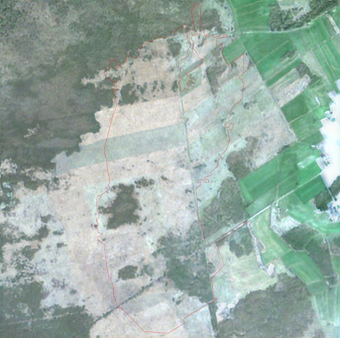
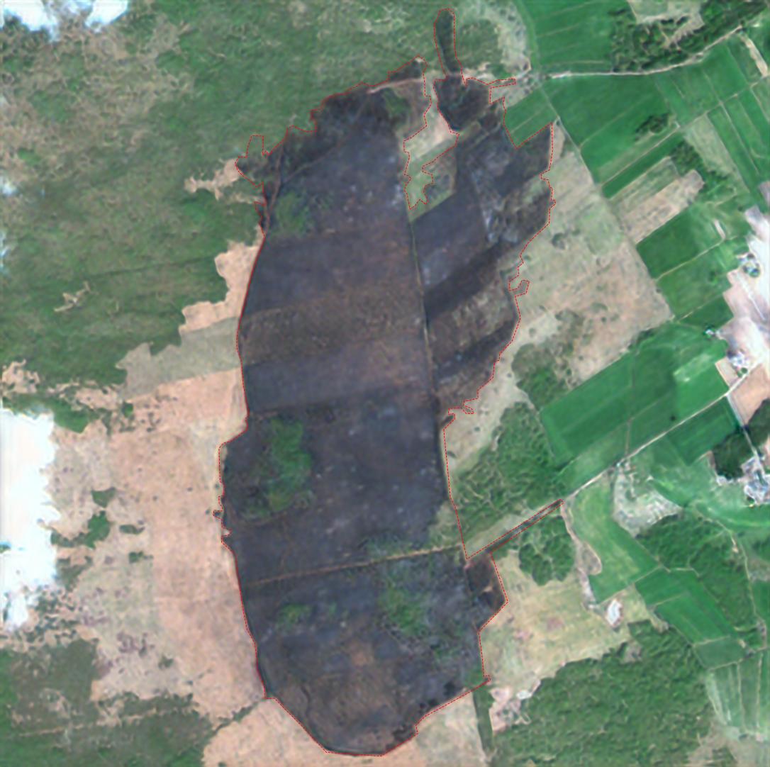
Satellite image comparison: the first image, taken on April 18, shows the area before the fire, while the second image from April 23 captures the aftermath, following the extinguishing of the blaze
The fire caused significant ecological disruption, particularly to bird populations. The affected areas are breeding grounds for species like the aquatic warbler, Eurasian crane, and black-tailed godwit. The timing of the fire, during the peak breeding season, likely destroyed nests and displaced wildlife. However, experts suggest that surface fires, like this one, allow for relatively rapid recovery. Reed beds and grasslands can regenerate within a year, provided water levels are restored. The absence of deep peat burning further supports recovery prospects, as peatlands remain intact to store water and support biodiversity.
The fire’s long-term impact depends on addressing the underlying drought. Without consistent rainfall or water management interventions, the park remains vulnerable to future fires. Conservationists advocate for enhanced monitoring and stricter enforcement against illegal grass burning, a common cause of wildfires in the region. The 2020 fire, likely sparked by such activities, serves as a stark reminder of human-driven risks.
Community and Government Response
The firefighting effort was bolstered by community support, with local residents providing food, equipment, and logistical assistance. Alerts from the Government Security Centre (RCB) warned residents of Augustów, Grajewo, and Mońki counties to avoid the fire zone and follow service instructions. Social media posts praised the dedication of firefighters and volunteers, while expressing concern over the recurring fires and their link to climate change.
Minister emphasized the need for climate adaptation strategies, noting that Podlasie’s hydrological challenges are part of a broader trend of decreasing precipitation. The government has pledged support for park restoration and fire prevention, including investments in water retention systems and public awareness campaigns against grass burning.
Conclusion
The April 2025 Biebrza National Park fire was a stark reminder of the vulnerability of Poland’s natural treasures to climate-driven wildfires. While the fire was contained with minimal damage to the Czerwone Bagno reserve, it underscored the urgent need for proactive measures to combat drought and prevent human-caused fires. OnGeo Intelligence’s satellite imagery provided a clear picture of the destruction, guiding future conservation efforts. With rainfall aiding containment and ecosystems poised for recovery, the focus now shifts to ensuring the park’s resilience against future threats. The collective efforts of firefighters, communities, and policymakers highlight the importance of unified action to protect Biebrza’s irreplaceable biodiversity.
We use cookies to run our website, analyze your use of our services, manage your online preferences & personalize ad content. By accepting our cookies, you'll get relevant content and social media features, personalized ads, and an enhanced browsing experience. To manage your choices, click "Cookie Settings." Necessary cookies are required for the core website functionality and cannot be rejected. For more information, see our Cookie Policy.
About cookies on this site
Cookies used on the site are categorized. Below you can allow or deny some or all of them, except for Necessary Cookies which are required to provide core website functionality. When categories that have been previously allowed are disabled, all cookies assigned to that category will be removed from your browser.
Some cookies are required to provide core functionality. The website won't function properly without these cookies and they are enabled by default and cannot be disabled.
Preference cookies enables the web site to remember information to customize how the web site looks or behaves for each user. This may include storing selected currency, region, language or color theme.
Analytical cookies help us improve our website by collecting and reporting information on its usage.
Marketing cookies are used to track visitors across websites to allow publishers to display relevant and engaging advertisements. By enabling marketing cookies, you grant permission for personalized advertising across various platforms.
The cookies in this category have not yet been categorized and the purpose may be unknown at this time.