🌍 Capture the world at 100% OFF! Use code ongeo100on 10 meters satellite image resolutions – limited time only! Higher resolution satellite images remain subject to payment.
🌍 Capture the world at 100% OFF! Use code ongeo100on 10 meters satellite image resolutions – limited time only! Higher resolution satellite images remain subject to payment.
When Satellite Images Lie: The Rise of Deepfake Geography
2025-04-16
(Article updated:
2025-04-16
)
~ 5 min
Can we still trust what we see from space? In the age of AI, even the seemingly objective eyes in the sky are no longer immune to manipulation. Deepfake satellite imagery – a new frontier in disinformation – is raising serious concerns for national security, journalism, humanitarian work and the integrity of geospatial data.
High-Quality Satellite Imagery, Hassle-Free
Explore any location on Earth with precision. Order a detailed Satellite Imagery Report—no sign-ups, no contracts. Delivered in a clear PDF for instant insights.
Satellite imagery has long been viewed as an irrefutable source of truth. Whether documenting wildfires, tracking troop movements, or exposing human rights abuses, these images have become critical tools for researchers, governments, and NGOs alike. Their perceived objectivity stems from the high costs and technical expertise involved in capturing them – typically by trusted institutions or commercial providers. But what happens when anyone with a bit of AI know-how can fabricate a realistic satellite photo?
Here comes so called deepfake geography
This emerging phenomenon involves the use of Generative Adversarial Networks (GANs) – a type of machine learning algorithm – to create synthetic satellite images that are nearly indistinguishable from real ones. Researchers like Bo Zhao from the University of Washington have demonstrated how GANs can generate fake cityscapes by blending features from different real cities, creating convincingly false visuals of nonexistent urban environments.
While deepfake videos of celebrities and politicians have captured the public's imagination, geographic deepfakes may pose an even greater risk. Unlike faces, satellite images don’t offer biometric cues like blinking or pulse to help flag manipulation. Instead, fakes can subtly alter the physical landscape – adding bridges, buildings, or entire neighborhoods that don’t exist. And because satellite data is now widely accessible through platforms like Google Earth and Sentinel Hub, the democratization of geospatial imagery also means an expanded attack surface.
According to Todd Myers of the U.S. National Geospatial-Intelligence Agency, GAN-based manipulations could one day trick military systems into planning operations around fake infrastructure. A falsified bridge or road could reroute convoys into traps. In a civilian context, a fake wildfire image could fuel panic, influence policy, or discredit accurate reporting.
Real case studies of imaginary places
The University of Washington team led by Zhao conducted experiments generating over 8,000 synthetic satellite images using GANs. They trained their model on real data from Seattle, Tacoma and Beijing, then created hybrids – „what-if” urban landscapes that blended features from each city. These weren’t just academic curiosities. Their study showed that fake images could successfully fool both humans and existing image-detection systems.
While detection algorithms eventually flagged 94% of the fake images, they also misclassified some of the real ones, highlighting the limitations of current safeguards. The experts caution that if society remains unaware of such threats, we risk descending into a "fake geography dystopia".
It's tempting to think of map forgery as a modern problem, but the practice has deep roots. Ancient civilizations invented mythical geographies to project power or spirituality. In more recent centuries, cartographers embedded "trap streets" and "paper towns” – fictitious locations inserted into maps to catch plagiarists. Deepfake satellite imagery is simply the digital evolution of this tradition, with far higher stakes and much more convincing tools.
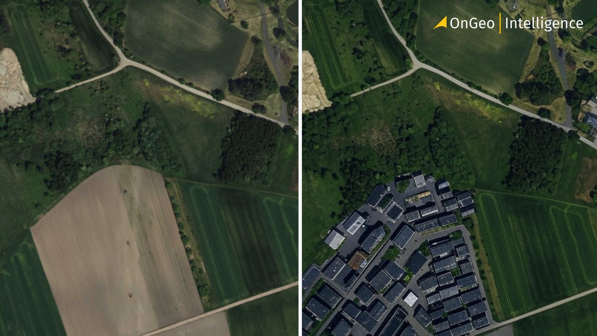
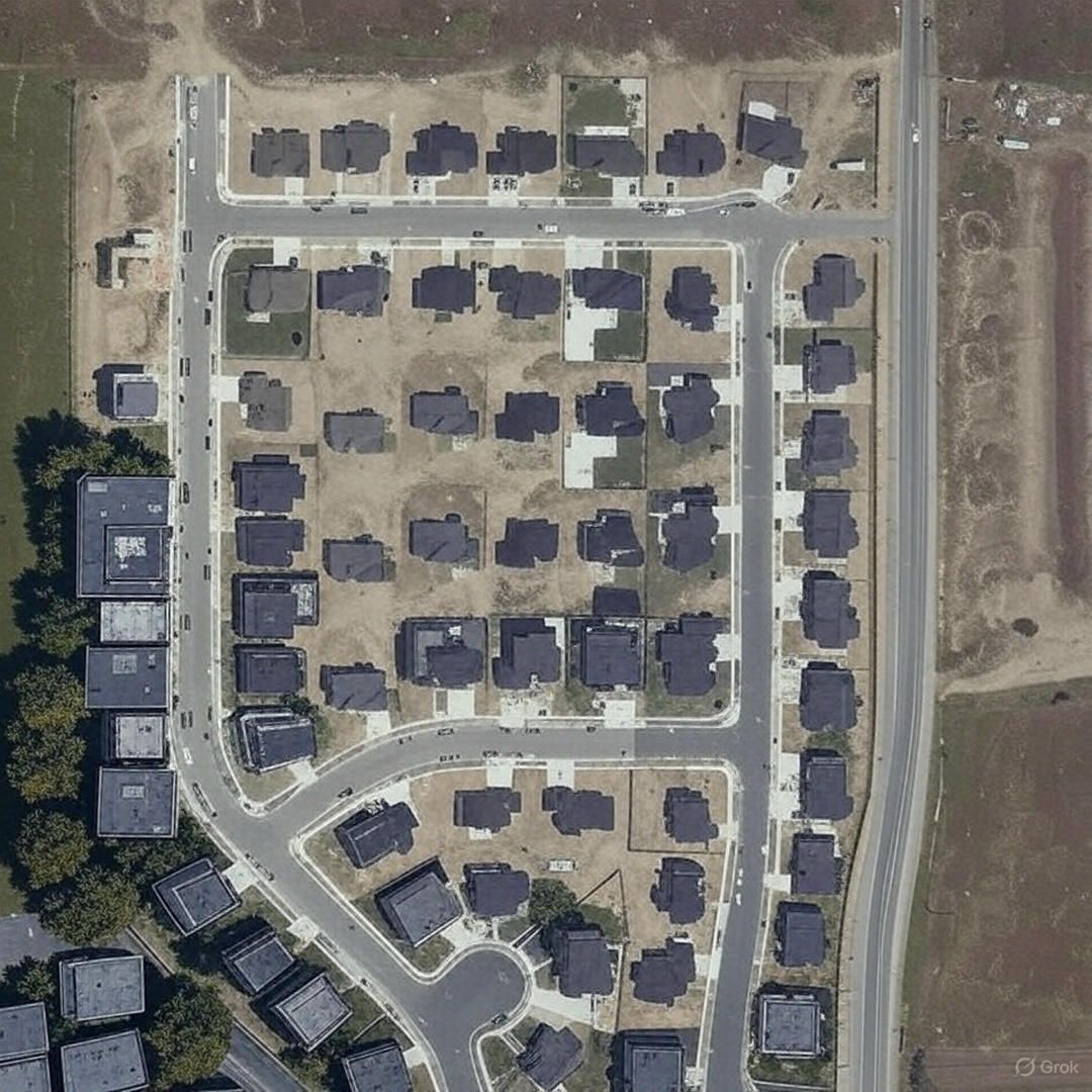
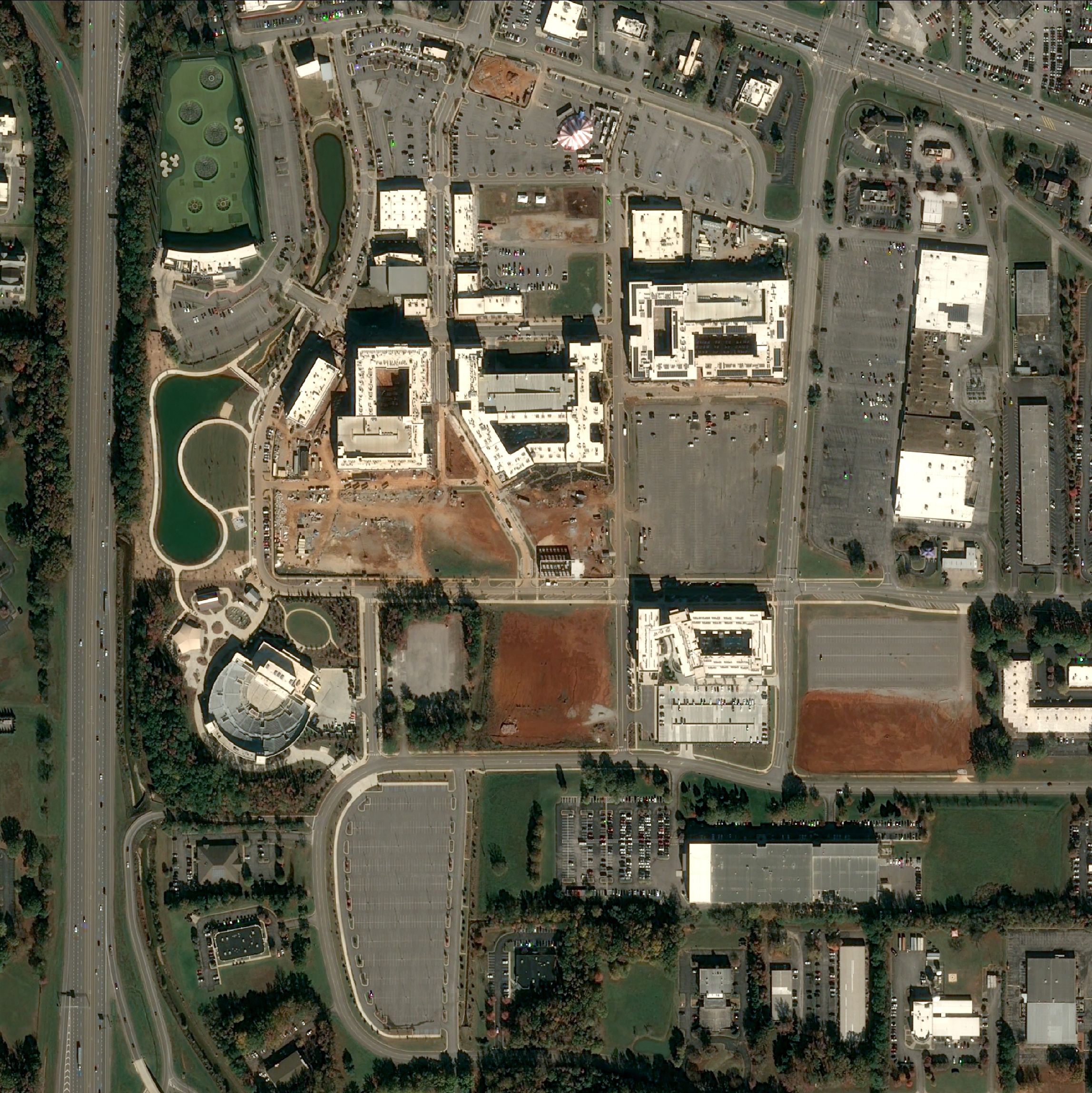
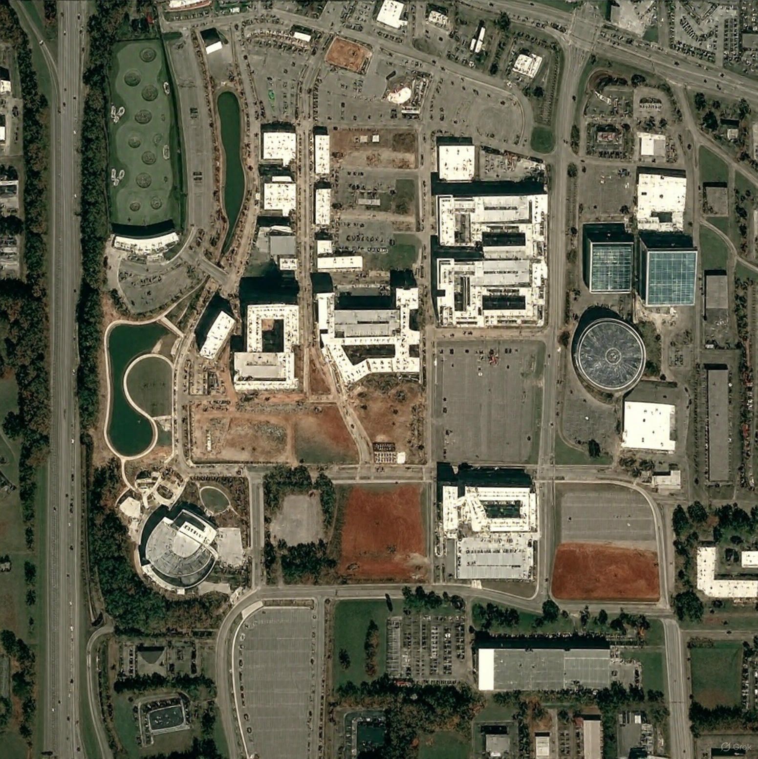
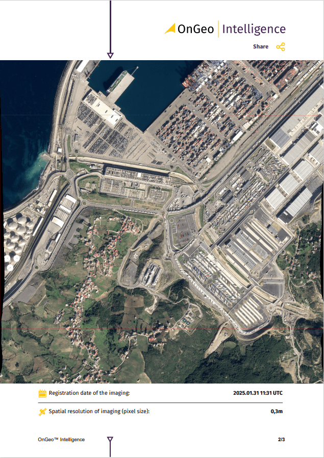
Examples of satellite images modified by AI
Original high-resolution Satellite Imagery, source: OnGeo Intelligence
Satellite image modified by AI, source: Grok
Original high-resolution Satellite Imagery, source: OnGeo Intelligence
Satellite image modified by AI, source: Grok
Detection and prevention: the arms race begins
Stopping deepfake geography isn't easy. The technical challenge lies in developing AI robust enough to detect manipulated imagery, especially as generative algorithms become more sophisticated. Researchers have begun to train machine learning models to identify telltale signs such as inconsistencies in texture, lighting and spectral characteristics. Still, detection is resource-intensive, often requiring multi-source verification and access to archival imagery.
Governments are starting to acknowledge the urgency. The U.S. military and intelligence community have launched initiatives to preserve the integrity of geospatial data. However, protecting open-source imagery – used by journalists, human rights organizations and even autonomous vehicle systems – remains a daunting task.
For the Earth Observation (EO) community, the implications are profound. EO relies on the assumption that satellite data reflects reality. If that assumption crumbles, so too does the credibility of countless applications – from climate monitoring to disaster response. It also puts pressure on EO providers to build tamper-evident workflows and develop public literacy aroundimage validation.
As Zhao’s team emphasizes, building “critical geospatial data literacy” is essential. Public awareness campaigns, better labeling of processed images and standardized metadata can help users assess the reliability of the content they consume. After all, trust in satellite imagery isn’t just about pixels – it’s about how societies make decisions based on those pixels.
Deepfake geography may still be in its early days, but it represents a seismic shift in how we perceive the Earth. As GANs continue to evolve, the line between authentic and artificial satellite imagery will blur. The EO field must adapt quickly, not only with technical defenses but also with transparent communication and cross-sector collaboration.
Why Choose OnGeo Intelligence?
Reliable source of spatial data.
High-resolution imagery for precise analysis.
Reliable and verifiable data suitable for court use.
Comprehensive historical archives to support long-term investigations.
For access to high-quality satellite imagery for your cases today.
We use cookies to run our website, analyze your use of our services, manage your online preferences & personalize ad content. By accepting our cookies, you'll get relevant content and social media features, personalized ads, and an enhanced browsing experience. To manage your choices, click "Cookie Settings." Necessary cookies are required for the core website functionality and cannot be rejected. For more information, see our Cookie Policy.
About cookies on this site
Cookies used on the site are categorized. Below you can allow or deny some or all of them, except for Necessary Cookies which are required to provide core website functionality. When categories that have been previously allowed are disabled, all cookies assigned to that category will be removed from your browser.
Some cookies are required to provide core functionality. The website won't function properly without these cookies and they are enabled by default and cannot be disabled.
Preference cookies enables the web site to remember information to customize how the web site looks or behaves for each user. This may include storing selected currency, region, language or color theme.
Analytical cookies help us improve our website by collecting and reporting information on its usage.
Marketing cookies are used to track visitors across websites to allow publishers to display relevant and engaging advertisements. By enabling marketing cookies, you grant permission for personalized advertising across various platforms.
The cookies in this category have not yet been categorized and the purpose may be unknown at this time.