🌍 Capture the world at 100% OFF! Use code ongeo100on 10 meters satellite image resolutions – limited time only! Higher resolution satellite images remain subject to payment.
🌍 Capture the world at 100% OFF! Use code ongeo100on 10 meters satellite image resolutions – limited time only! Higher resolution satellite images remain subject to payment.
Generate Satellite Imagery Reports for Free – Limited Time Offer!
2025-04-23
(Article updated:
2025-04-23
)
~ 5 min
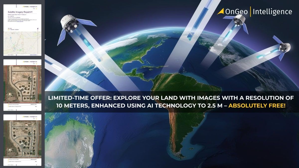
Satellite imagery, once exclusive, is now accessible to everyone thanks to OnGeo Intelligence. For a limited time, use the exclusive code to generate professional 10m resolution (AI-enhanced to 2.5m) satellite imagery reports absolutely free. Discover how easy it is to explore Earth from above, even directly from your smartphone.
High-Quality Satellite Imagery, Hassle-Free
Explore any location on Earth with precision. Order a detailed Satellite Imagery Report—no sign-ups, no contracts. Delivered in a clear PDF for instant insights.
Generate free Satellite Imagery Report – limited time offer!
Satellite imagery has always been seen as a tool reserved for experts or large organizations. OnGeo Intelligence is changing that perception by making satellite data accessible to everyone.
With the exclusive code: ongeo100 you can generate professional free satellite imagery reports
This offer includes images with a resolution of 10 meters (enhanced using AI technology to 2.5 m), while high-resolution imagery (from 0.3 m to 2 m) remains available as a paid option.
Whether you're a property owner, farmer, lawyer, or simply curious about exploring Earth from above, this service empowers you with cutting-edge technology at your fingertips.
And the best part? You can access and order reports directly from your smartphone, making the process even more convenient.
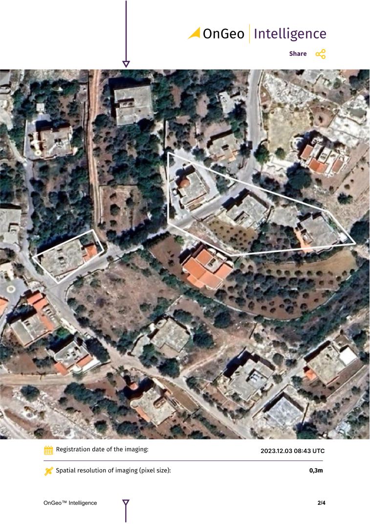
What is the Satellite Imagery Report by OnGeo Intelligence?
The Satellite Imagery Report is an innovative service offered on the OnGeo Intelligence platform.
It provides users with access to high-quality satellite data in an easy-to-use PDF format, enabling anyone to analyze and monitor their area of interest without requiring technical expertise or subscriptions.
This makes obtaining crucial visual evidence or monitoring landscape changes straight forward and accessible.
Using the Satellite Imagery Report service is simple and accessible for everyone:
Select location and time period Pinpoint the area you want to analyze on an interactive map and specify the date range.
Search archives The platform automatically locates satellite images available for your selected area and period.
Add images to your cart Browse through the results and add your preferred scenes to your cart – all from your smartphone or desktop device.
Enter code ongeo100 at checkout Apply the code during checkout to unlock free access to your report with 10 m resolution images enhanced using AI technology to 2.5 m per pixel. High-resolution satellite images remain a paid service.
Receive your report via email Low-resolution reports are delivered within minutes, while high-resolution reports are available within 48 hours.
Why act now?
The code ongeo100 provides access to free satellite imagery reports for a limited 30 days only!
Don’t miss this opportunity to explore Earth’s surface from above while saving time and money on professional geospatial data.
Why choose OnGeo Intelligence?
OnGeo Intelligence redefines accessibility by making advanced satellite imagery available to everyone - no matter their background or expertise.
Benefits of Using OnGeo Intelligence
Free access to satellite imagery with code ongeo100: Generate reports at no cost during this promotion period for resolutions up to 10 m.
High-resolution precision: For detailed analysis, paid options offer resolutions from 0.3 m to 2 m – perfect for critical applications like construction monitoring or legal disputes.
Mobile-friendly platform: Order and manage reports conveniently from your smartphone – perfect for users on the go.
Global reach: Analyze any location worldwide with ease.
Fast delivery: Receive low-resolution reports in just minutes and high-resolution data within 48 hours.
AI-enhanced imagery: Enjoy sharper visuals with AI technology that enhances lower-resolution images for improved clarity.
Versatile applications: Perfect for real estate monitoring, legal disputes, crop management, construction tracking, environmental observation, and more.
Ready to unlock free Satellite Imagery Report?
Use code ongeo100 today and experience the power of advanced geospatial data at no cost!
Real-life applications of Satellite Imagery Reports
The Satellite Imagery Report is a versatile tool that meets the needs of professionals and individuals alike:
Lawyers Use high-resolution imagery as indisputable evidence in legal cases involving property disputes or construction claims.
Environmentalists Track deforestation, water level fluctuations, or urban expansion with detailed imagery covering any location on Earth.
Property Owners Monitor changes on your land over time or resolve boundary disputes with clear evidence from satellite images.
Farmers Optimize crop management by analyzing soil moisture, vegetation health (NDVI), and water content (NDWI) using advanced indices included in the report.
Frequently asked questions (FAQ)
What does the ongeo100 code provide? The code grants free access to satellite imagery reports with a resolution of 10 m enhanced using AI technology to 2.5 m per pixel.
Do I need an account to use this service? No account registration or subscription is required—simply follow the steps outlined above.
How long does it take to receive my report? Low-resolution reports are delivered within minutes; high-resolution reports may take up to 48 hours.
Can I use this service anywhere in the world? Yes! OnGeo Intelligence provides global coverage—reports can be generated for any location on Earth.
Can I access this service from my phone? Absolutely! The platform is fully mobile-friendly, allowing you to order and receive reports directly from your smartphone.
We use cookies to run our website, analyze your use of our services, manage your online preferences & personalize ad content. By accepting our cookies, you'll get relevant content and social media features, personalized ads, and an enhanced browsing experience. To manage your choices, click "Cookie Settings." Necessary cookies are required for the core website functionality and cannot be rejected. For more information, see our Cookie Policy.
About cookies on this site
Cookies used on the site are categorized. Below you can allow or deny some or all of them, except for Necessary Cookies which are required to provide core website functionality. When categories that have been previously allowed are disabled, all cookies assigned to that category will be removed from your browser.
Some cookies are required to provide core functionality. The website won't function properly without these cookies and they are enabled by default and cannot be disabled.
Preference cookies enables the web site to remember information to customize how the web site looks or behaves for each user. This may include storing selected currency, region, language or color theme.
Analytical cookies help us improve our website by collecting and reporting information on its usage.
Marketing cookies are used to track visitors across websites to allow publishers to display relevant and engaging advertisements. By enabling marketing cookies, you grant permission for personalized advertising across various platforms.
The cookies in this category have not yet been categorized and the purpose may be unknown at this time.