🌍 Capture the world at 100% OFF! Use code ongeo100on 10 meters satellite image resolutions – limited time only! Higher resolution satellite images remain subject to payment.
🌍 Capture the world at 100% OFF! Use code ongeo100on 10 meters satellite image resolutions – limited time only! Higher resolution satellite images remain subject to payment.
Hidden Buildings, Lost Taxes: How Satellite Imagery and AI Help Detect Unregistered Properties
2025-04-08
(Article updated:
2025-04-08
)
~ 3 min
Every year, municipalities around the world lose millions in property tax revenue — not because residents are refusing to pay, but because many buildings are simply invisible to tax authorities. Unregistered constructions, undeclared expansions and outdated cadastral records are widespread, especially in rapidly growing urban and peri-urban areas. In some regions, entire neighborhoods have sprung up without a trace in official databases. As a result, property tax collection remains inaccurate and unfair, and public budgets suffer. This situation, however, is changing, thanks to advances in satelliteEarth Observation (EO) and artificial intelligence (AI).
High-Quality Satellite Imagery, Hassle-Free
Explore any location on Earth with precision. Order a detailed Satellite Imagery Report—no sign-ups, no contracts. Delivered in a clear PDF for instant insights.
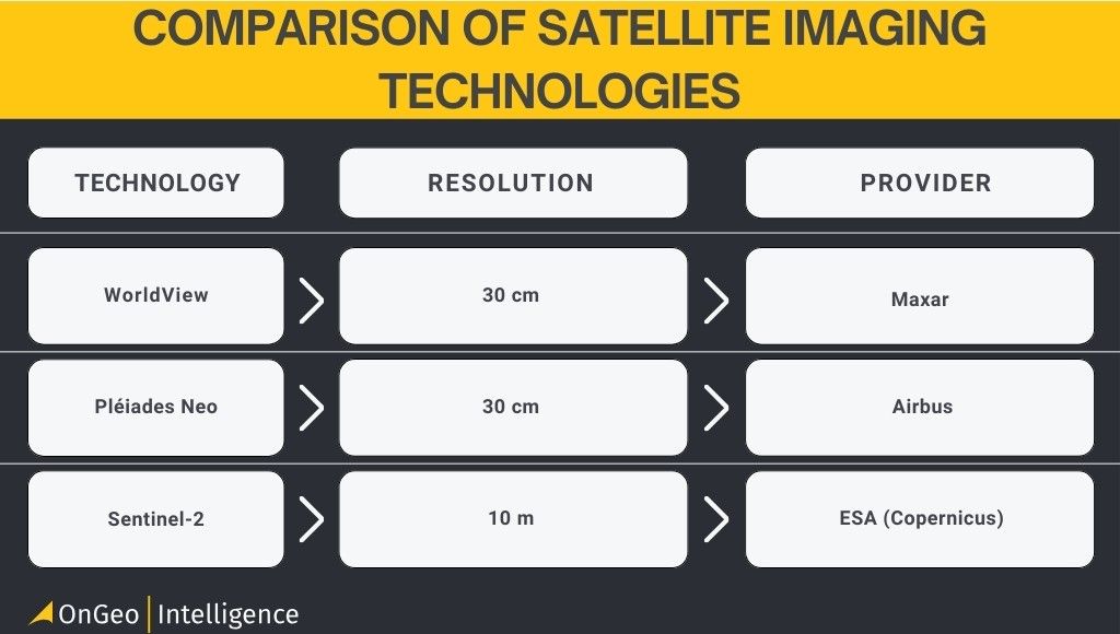
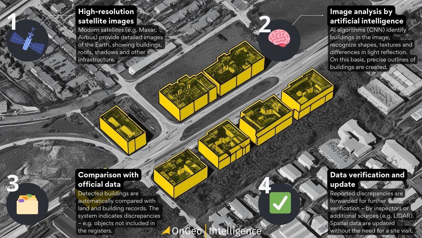
Today, very high-resolution (VHR) optical satellites like Maxar’s WorldView, Airbus’s Pléiades Neo, or PlanetScope are capable of capturing ground-level detail at 30–50 centimeters per pixel. With such imagery, individual buildings and even small annexes or outbuildings are clearly visible. But having images is only the beginning. The real power comes from automated analysis. Deep learning algorithms - particularly convolutional neural networks trained on thousands of satellite images - can now accurately detect building footprints. These models analyze roof shapes, spectral reflectance, shadows and surrounding patterns to delineate building outlines with impressive precision.
Comparison of Satellite Imaging Technologies
How Does It Work?
Once detected, the extracted building footprints are compared with cadastral data or land parcel records. This overlay analysis reveals discrepancies: buildings visible on imagery but missing from official registers are flagged for inspection. Authorities can then verify these cases on the ground or, increasingly, by using additional remote sensing data. The impact of such systems is already visible around the world. In France, for instance, satellite analysis uncovered thousands of undeclared swimming pools, resulting in €10 million in additional tax revenue in just one year. Meanwhile, institutions like the Asian Development Bank are promoting the adoption of EO-based property auditing in developing countries, recognizing its potential to strengthen urban governance and fiscal health.
How automatic building detection from satellite imagery works
Beyond Boosting Revenue
The use of satellite-based building detection is not just about boosting revenue. Accurate and up-to-date building data support better city planning, more equitable service delivery, and stronger disaster response. Governments can allocate resources based on real, observed land use rather than outdated or incomplete records. At the same time, ensuring everyone pays their fair share of taxes improves trust in public institutions and helps reduce corruption.
Challenges in Satellite-Based Detection
Of course, the technology isn’t flawless. Shadows, tree cover and dense urban morphology can challenge even the best AI models.Legal boundaries rarely align perfectly with physical footprints and the material or condition of roofs can complicate classification. Still, with the integration of auxiliary data — such as LIDAR, aerial imagery, or even Google Street View, detection accuracy improves dramatically. Some companies, like Tensorflight, are already combining these sources to offer ready-to-use property intelligence services for insurers and local governments.
The Future of Property Auditing
As costs of satellite data continue to fall and cloud computing platforms make analysis more accessible, the future of cadastral intelligence looks increasingly automated. Cities and regions can expect to maintain near real-time property records, updated directly from space. In this new paradigm, urban change no longer needs to wait for field surveys or paper filings. Instead, buildings will be tracked, categorized, and valuedusing satellite pixels and neural networks.
The implications of this shift are profound. Satellite imagery and AI are not just enhancing how we see the Earth — they are changing how we govern it. By bringing transparency to property ownership and land use, Earth Observation technologies can help build fairer, smarter and more resilient communities. And perhaps most importantly, they ensure that no building — and no taxpayer — stays hidden for long.
We use cookies to run our website, analyze your use of our services, manage your online preferences & personalize ad content. By accepting our cookies, you'll get relevant content and social media features, personalized ads, and an enhanced browsing experience. To manage your choices, click "Cookie Settings." Necessary cookies are required for the core website functionality and cannot be rejected. For more information, see our Cookie Policy.
About cookies on this site
Cookies used on the site are categorized. Below you can allow or deny some or all of them, except for Necessary Cookies which are required to provide core website functionality. When categories that have been previously allowed are disabled, all cookies assigned to that category will be removed from your browser.
Some cookies are required to provide core functionality. The website won't function properly without these cookies and they are enabled by default and cannot be disabled.
Preference cookies enables the web site to remember information to customize how the web site looks or behaves for each user. This may include storing selected currency, region, language or color theme.
Analytical cookies help us improve our website by collecting and reporting information on its usage.
Marketing cookies are used to track visitors across websites to allow publishers to display relevant and engaging advertisements. By enabling marketing cookies, you grant permission for personalized advertising across various platforms.
The cookies in this category have not yet been categorized and the purpose may be unknown at this time.