High Resolution Satellite Imagery: Best Quality Sources
In today's digitally advanced world, high resolution satellite imagery has become a pivotal resource across a multitude of sectors. The ability to access highly detailed views from above not only enhances our understanding of Earth's surface but revolutionizes decision-making processes in various fields. With advances in spatial resolution, the quest for the highest quality satellite imagery is more pertinent than ever. This crave for detail extends beyond simple curiosity, bearing significant implications for environmental monitoring, urban planning, agriculture, and much more.
This article will guide you through the essentials of high resolution satellite imagery, discussing its importance and the advancements that have elevated its quality to the highest standards. We will explore the various applications of high resolution imagery in different sectors, highlighting the advantages it holds over lower resolution counterparts. Moreover, you'll gain insights into how to obtain these high resolution satellite maps and images to meet your specific needs, ensuring you have access to the very high resolution satellite imagery necessary for your projects.
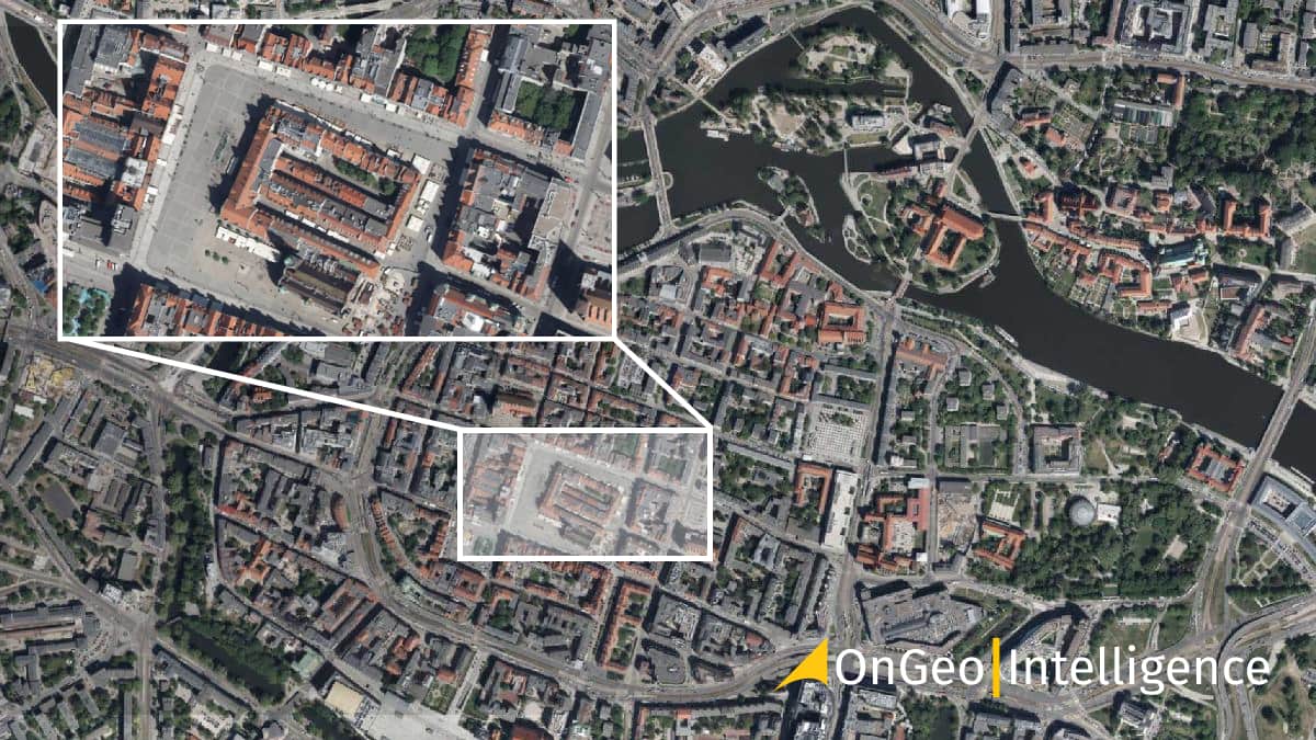
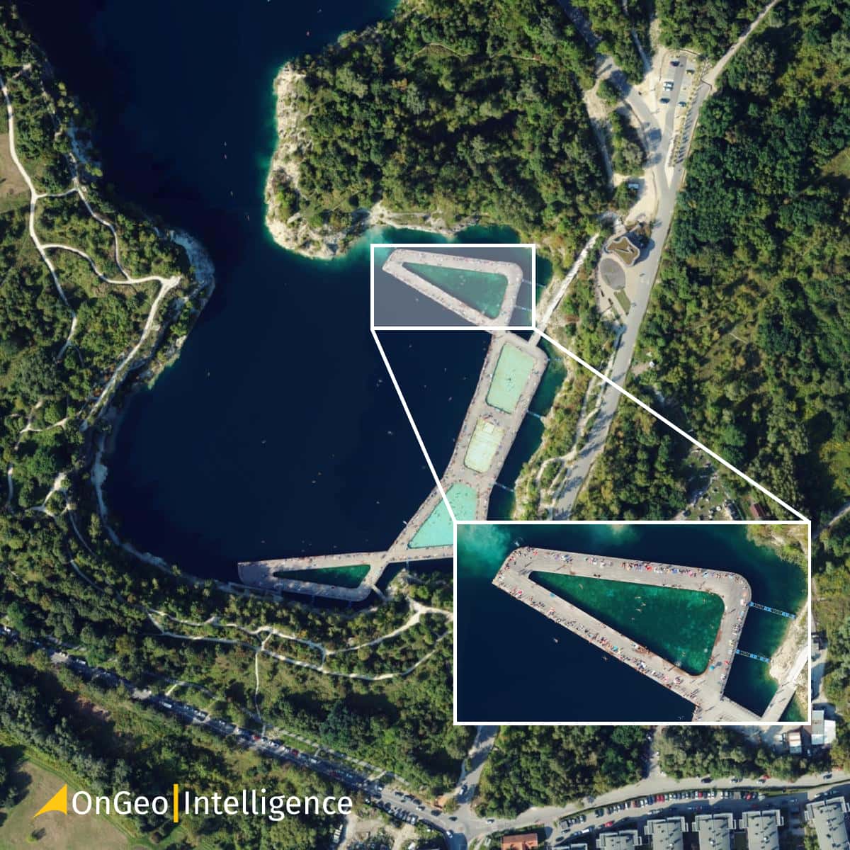
Discover your best source for Very High Resolution (VHR) Satellite Images: OnGeo™ Intelligence Satellite Imagery Report Service
The OnGeo™ Intelligence Satellite Imagery Report service offers a fast, convenient, and high-quality solution for obtaining high resolution satellite imagery. Our service delivers comprehensive, natural color (RGB) satellite images in an easy-to-use PDF format.
Key features:
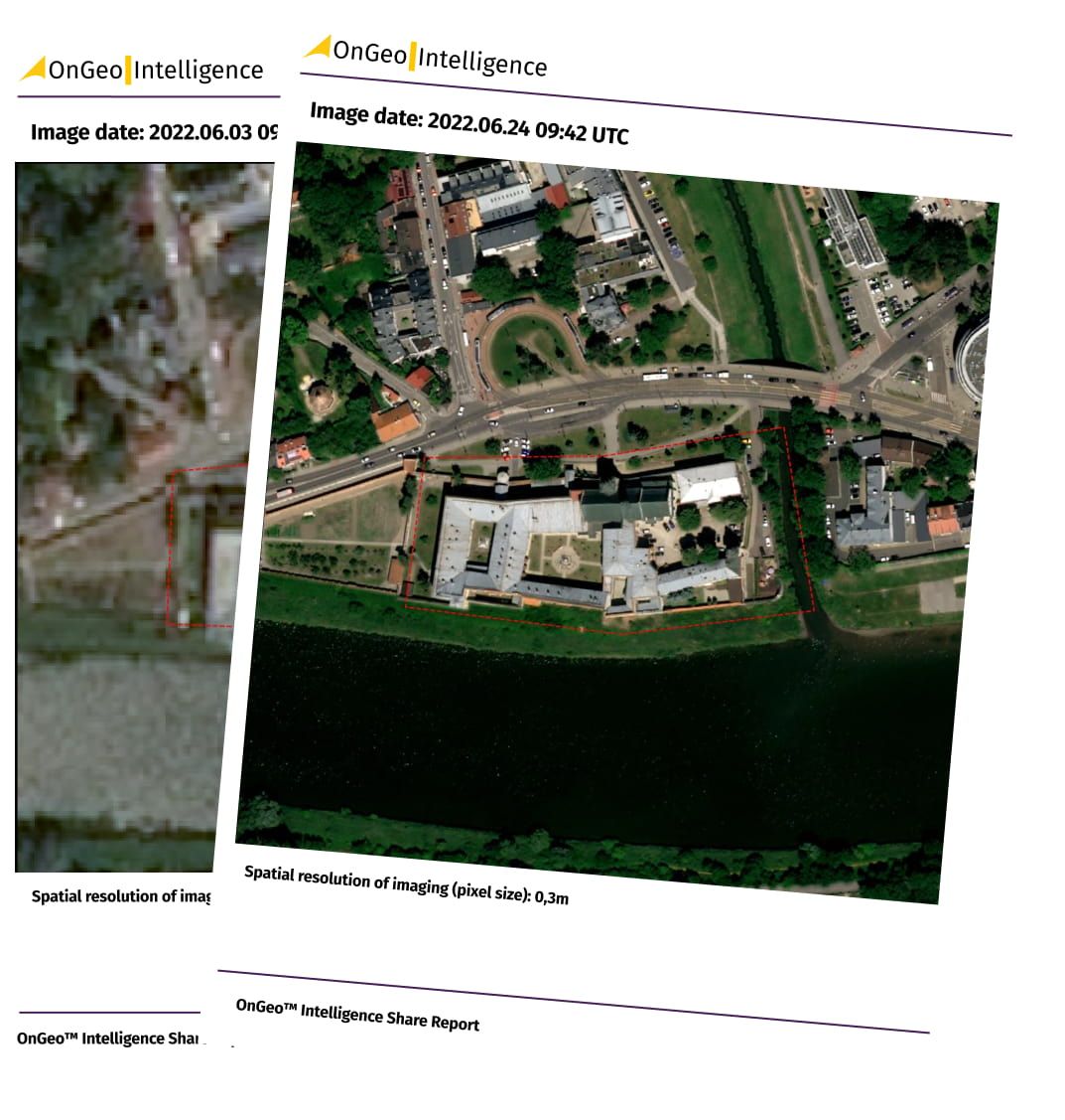
- Quick order process: Submit your order in minutes; receive your report in just 5 minutes for low resolution scenes and up to a maximum of 48 hours for high-resolution data.
- No registration required: Order without creating an account.
- Pay-as-you-go: Only pay for the reports you need, with no subscriptions.
- High-quality imagery: Access detailed images with various pixel sizes, including:
- high resolution:
- 0.3 meters (Very High Resolution VHR),
- 0.3-1 meters,
- 1.0-2.0 meters
- medium resolution :
- 10 meters (sharpened to 2.5 meters).
- high resolution:
Visit OnGeo™ Intelligence today to order your satellite imagery report and experience the convenience and quality of our top-notch satellite imagery service.
Also read:
More information about the Satellite Imagery Report
Understanding high resolution satellite imagery
What constitutes high resolution?
High-resolution satellite imagery involves capturing data where each pixel in the image represents a small area on the ground. This allows for detailed viewing and analysis of features on Earth's surface. Optical satellite images are typically captured in visible and infrared spectrums, while synthetic aperture radar (SAR) images use the microwave portion of the electromagnetic spectrum.
The classification of optical satellite imagery by resolution is as follows:
- low resolution (>20 m),
- medium/coarse resolution (>2 m to ≤20 m),
- high resolution (>50 cm to ≤2 m),
- very high resolution VHR (≤50 cm).
SAR imagery resolution, on the other hand, is determined by the wavelength of data collection, with smaller wavelengths capturing finer details.
Technical specifications
The spatial resolution, or ground sample distance (GSD), is a critical measure indicating the size of the ground area each pixel covers. For instance, a spatial resolution of 15 meters means each pixel corresponds to a 15 by 15 meters square on the ground. As spatial resolution improves, the pixel size decreases, enabling the detection of smaller and more detailed features such as vehicles, buildings, and even individual people.
Several factors influence spatial resolution:
- Satellite altitude: Higher altitudes cover larger areas but offer lower resolution.
- Temporal resolution: This refers to how often a satellite can image the same location, affected by the orbit period and sensor swath width. A narrower swath width, which provides higher spatial resolution, takes longer to revisit the same point on Earth.
Commercial satellite imagery typically ranges from 2 to 5 meter resolution, with high resolution sensors capturing details down to 70, 50, and 30 centimeters. These high resolution images are crucial for applications requiring detailed observation and decision-making, such as urban planning and environmental monitoring.
Understanding these technical specifications helps you choose the appropriate resolution for your specific needs, ensuring you do not pay for excessively high resolutions that may not provide additional benefits for your project.
Applications in various sectors
Agriculture
High resolution satellite imagery is transforming agriculture by enabling precision farming. Through the use of multispectral images, farmers can monitor crop health, optimize irrigation, and detect pests more effectively. This technology allows for the analysis of vegetation index such as NDVI, which assesses plant health by measuring reflectance in specific bands of light. Additionally, high frequency satellite solutions like those from Planet provide daily imagery that supports crop management throughout the growing season, enhancing productivity and sustainability.
Environmental studies
In environmental studies, high resolution satellite imagery plays a crucial role in monitoring and assessing changes in ecosystems. It aids in the creation of detailed GIS maps that track land cover and land use changes over time. This is essential for identifying environmentally safe areas for development and for conducting environmental impact assessments. The imagery also supports the study of natural resources and helps in disaster management by providing data that can predict and mitigate the effects of natural disasters.
Urban planning and development
Urban planning and development greatly benefit from high resolution satellite imagery. It provides essential data for updating information on urban infrastructure, analyzing population density, and planning housing developments. The imagery assists in managing urban sprawl and supports decision-making for sustainable urban development. For instance, the use of LiDAR and high resolution imagery helps urban planners in flood prevention and infrastructure modeling. Satellite imagery also enables the monitoring of construction projects and infrastructure health, ensuring that urban development is both efficient and sustainable.
Security and defense
Military and security agencies use high resolution satellite imagery for reconnaissance, surveillance, and intelligence gathering. The detailed images help in identifying potential threats, monitoring border areas, and planning strategic operations.
Companies providing high resolution satellite imagery
Several companies are leading providers of high resolution satellite imagery, each offering unique capabilities and satellite constellations. Here are some of the key players:
1. Maxar technologies
Maxar Technologies, previously known as DigitalGlobe, is a major provider of high resolution satellite imagery. Maxar's WorldView constellation includes:
- GeoEye-1: constellation satellites provide high-resolution imagery with a pixel size of 0.41 meters (panchromatic) and 1,84 (multispectral).
- WorldView-1: Panchromatic images with a 50 cm resolution.
- WorldView-2: Multispectral images with a 46 cm resolution (panchromatic) and 1.85 m (multispectral).
- WorldView-3: Panchromatic images with a 31 cm resolution and multispectral with a 1.24 m resolution.
- WorldView-4: Offers panchromatic images with a 31 cm resolution and multispectral images with a 1.24 m resolution.
2. Airbus defence and space
Airbus operates several high resolution satellites under its Pléiades and SPOT series:
- Pléiades 1A and 1B: Provide panchromatic images with a 50 cm resolution and multispectral images with a 2 m resolution.
- SPOT 6 and SPOT 7: Offer 1.5 m resolution (panchromatic) and 6 m resolution (multispectral) imagery, suitable for large-area coverage.
- Pleiades Neo: Offers panchromatic imagery with a 0.3-meter resolution and multispectral imagery with a 1.2-meter resolution.
3. Planet labs
Planet Labs is known for its large constellation of small satellites, known as Doves, and high resolution SkySat satellites:
- SkySat: High resolution imagery with 50 cm resolution (panchromatic) and 1 m resolution (multispectral).
- Dove: Medium-resolution images with 3-5 m resolution, providing daily global coverage.
4. ICEYE
ICEYE specializes in synthetic aperture radar (SAR) imagery with its constellation:
- ICEYE-X1 to ICEYE-X6: These satellites provide SAR imagery with a resolution of up to 1 meter, useful for monitoring areas regardless of weather conditions.
5. BlackSky
BlackSky provides rapid-revisit high resolution imagery:
- Global Series: Offering images with up to 1 meter resolution, allowing for frequent revisits and near-real-time monitoring.
Also read:
The future of high resolution satellite imagery
The future of high resolution satellite imagery is promising, with advancements in technology continually pushing the boundaries of what is possible:
1. Increased resolution
As technology progresses, the resolution of satellite images is expected to improve further, allowing for even finer details to be captured. This will enhance the accuracy and utility of satellite data across various applications.
2. Real-time imaging
Developments in satellite technology aim to reduce the time between image capture and availability. Real-time or near-real-time imaging will revolutionize fields such as disaster response, security, and environmental monitoring, providing immediate insights and enabling swift action.
3. Enhanced spectral capabilities
Future satellites will likely have enhanced spectral capabilities, capturing more detailed information across a broader range of wavelengths. This will improve the ability to identify and monitor specific materials and conditions on the Earth's surface.
4. Integration with AI and machine learning
The integration of artificial intelligence (AI) and machine learning with high resolution satellite imagery will enable automated analysis and interpretation of vast amounts of data. This will streamline processes, uncover hidden patterns, and provide actionable insights faster than ever before.
In conclusion, high resolution satellite imagery stands at the forefront of technological innovation, offering unparalleled views of our planet. Its applications span a wide range of fields, providing critical insights that drive progress and improve our understanding of the world. As technology advances, the capabilities and impact of high resolution satellite imagery will continue to expand, heralding a future of greater clarity and precision.
How to obtain high resolution images
One-time purchase options
The best example of a one-time service is OnGeo™ Intelligence, the platform presented at the beginning of the article. OnGeo™ Intelligence allows for on-demand access to the most recent and highest resolution commercial satellite imagery. Through an easy in-app purchase process, you can preview, select, and receive satellite imagery for any location on demand.
Subscription services
For continuous access to high resolution satellite imagery, subscription services offer a practical solution. Maxar Intelligence provides a comprehensive suite of commercial satellite imagery through its subscription model, which includes fresh high resolution imagery and access to the world's largest historical archive.
Free resources
For those seeking no-cost options, several platforms offer free high resolution satellite imagery. Google Earth provides access to some of the highest resolution satellite imagery for free, although the very highest resolution images are often aerial photographs. Sentinel Hub is a popular choice for accessing a wide range of satellite data, including the Sentinel and Landsat products, without any cost. Additionally, Earth Explorer and NASA Worldview offer extensive archives of free satellite imagery, which can be a valuable resource for educational and non-commercial projects.
Conclusion
Throughout this article, we delved into the unparalleled value of high resolution satellite imagery in enhancing our understanding and management of the world around us. From agriculture to urban planning and environmental monitoring, we explored how these detailed aerial views empower various sectors, promoting precision, efficiency, and informed decision-making. The technological advancements and availability of satellite images have indeed opened new horizons in data analysis and project planning. By harnessing the power of high resolution satellites, individuals and organizations can obtain a level of detail that was once unimaginable, transforming how we approach challenges and solutions in an array of fields.
In light of these discussions, the OnGeo Intelligence Satellite Imagery Report emerges as a pivotal tool. This service simplifies the process of accessing tailored, high resolution satellite imagery to support a wide range of projects and decisions. With no need for a subscription, it offers an easy, straightforward way to order and receive a comprehensive report of your specified area, including a curated selection of images in natural colors. Whether for monitoring environmental changes, planning urban developments, or advancing agricultural practices, the OnGeo Intelligence report equips you with the insights needed to evaluate and track progress over time. Ultimately, the integration of such advanced satellite imagery services underscores the evolving landscape of data utilization, promising to enhance our capabilities in research, planning, and beyond.
FAQs
1. Which companies currently provide the highest-resolution satellite imagery?
As of May 2024, the leading providers of the highest-resolution satellite imagery to the public include Maxar Technologies, Planet Labs, 21st Century Aerospace Technology, and Airbus Defense and Space.
2. What is the highest-resolution satellite image ever produced commercially?
As of August 07, 2023, Umbra, a company specializing in advanced space radar technology, released a commercial satellite image with a resolution of 16-cm using Synthetic Aperture Radar (SAR), marking it the highest-resolution to date.
3. How can I obtain high resolution satellite images from Google Maps?
To download hi-res satellite images from Google Maps, follow these steps: Navigate to File | Save | Save Image, then click on 'Map Options' to disable various map elements. Next, click on the 'Resolution' button, select 'Maximum,' and finally, click on 'Save Image' to capture the image in high resolution.
4. What methods can be used to enhance the resolution of a satellite image?
Enhancing the resolution of a satellite image can be achieved by using a satellite equipped with a larger sensor, which allows more light collection and finer details. Alternatively, using a satellite that orbits closer to Earth can also improve resolution, as it reduces the field of view but increases the detail in the images captured.
Related articles
- Real-Time Satellite Imagery
- Satellite Imagery Archives: How to Access Historical Satellite Images
- Satellite Imagery Report - generate it yourself
- What Is Location Intelligence? A Guide for Modern Businesses
- Why Accuracy Matters in High-Resolution Satellite Imagery
- How to Get a Current Satellite Map of My Property