🌍 Capture the world at 100% OFF! Use code ongeo100on 10 meters satellite image resolutions – limited time only! Higher resolution satellite images remain subject to payment.
🌍 Capture the world at 100% OFF! Use code ongeo100on 10 meters satellite image resolutions – limited time only! Higher resolution satellite images remain subject to payment.
Devastating March 2025 Wildfires Scorch Over in South Korea: Satellite Images Reveal the Damage
2025-04-10
(Article updated:
2025-04-10
)
~ 5 min
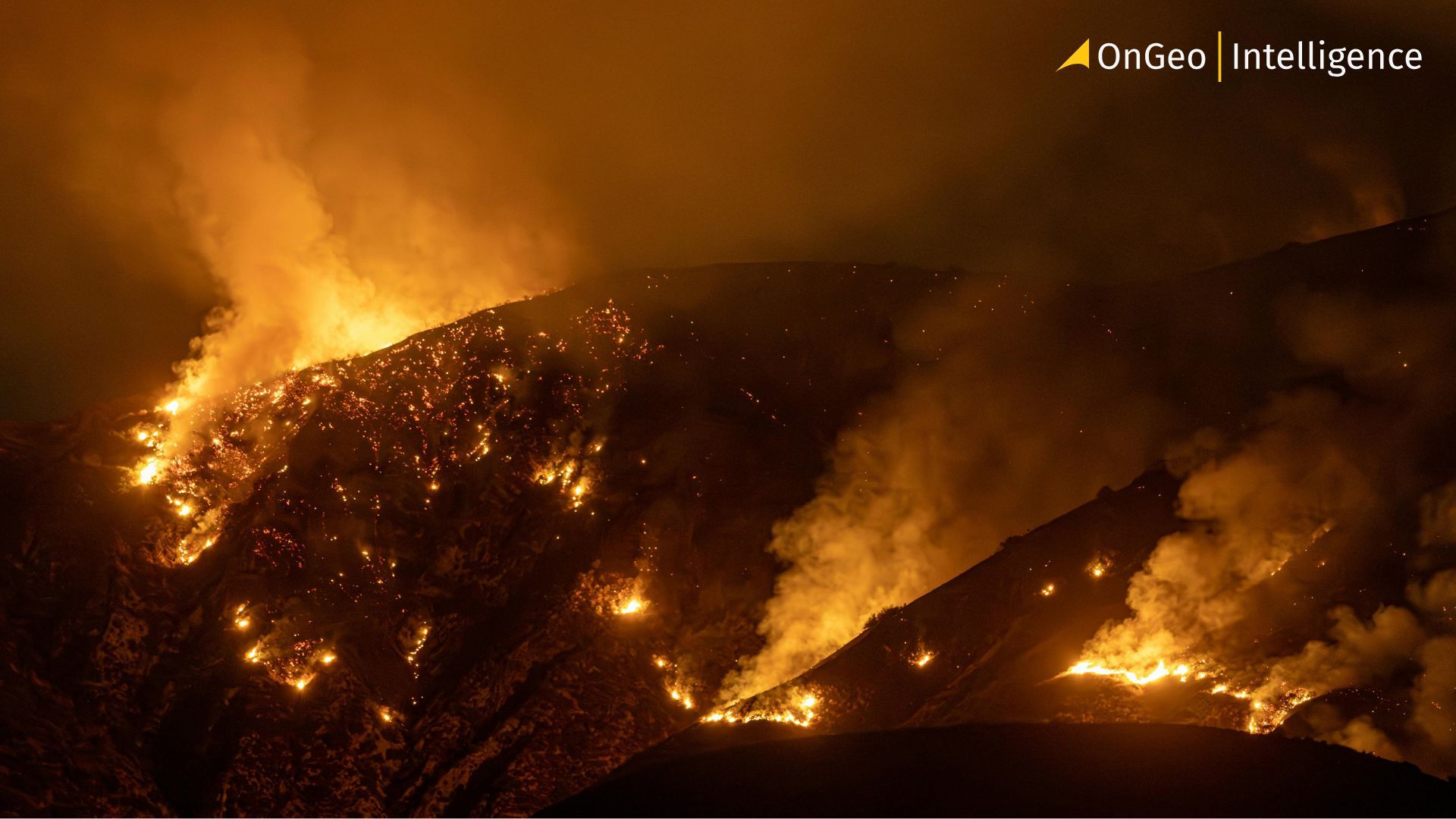
A series of catastrophic wildfires tore through South Korea in March 2025, leaving a trail of destruction across over 170,000 hectares of land. Sparked during a period of strong, dry winds and rapid spread, the fires destroyed thousands of homes and historical sites. Now, striking before-and-after satellite images from Sentinel-2 reveal the full scale of the devastation, using SWIR, NIR, and RGB spectral bands and vegetation indices to map the burned regions with unprecedented clarity.
High-Quality Satellite Imagery, Hassle-Free
Explore any location on Earth with precision. Order a detailed Satellite Imagery Report—no sign-ups, no contracts. Delivered in a clear PDF for instant insights.
South Korea’s March 2025 Wildfires Leave a Scorched Trail
A relentless outbreak of wildfires swept through southern regions of South Korea in March 2025, consuming over 170,000 hectares of land and marking one of the country’s worst fire disasters in modern history.
Beginning around March 21 under dry, gusty conditions, the fires escalated rapidly. Within days, dozens of fires had erupted, with the most destructive blazes emerging near the southeastern city of Andong and spreading to Yeongyang, Uljin, and Cheongsong. Winds stronger than typhoons and mountainous terrain amplified the fires’ speed and unpredictability.
By March 25, satellite thermal anomalies showed the fire had reached all the way to the coastline. With light rain and firefighting efforts helping slow the advance, the fires were largely contained by March 28.
But the destruction left behind was immense.
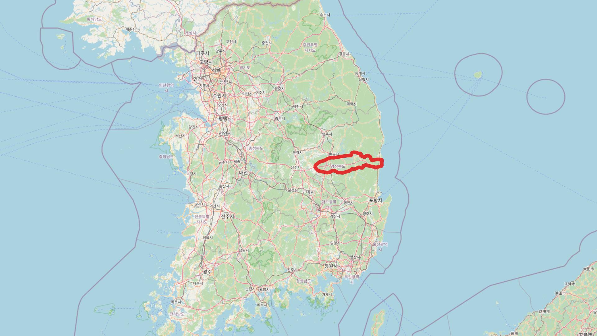
Map of South Korea highlighting the regions affected by the March 2025 wildfires.The area shows the extensive burn scar that stretches across North Gyeongsang Province, including Uiseong, Andong and Yeongyang.
Satellite Images Reveal the Scale of Destruction
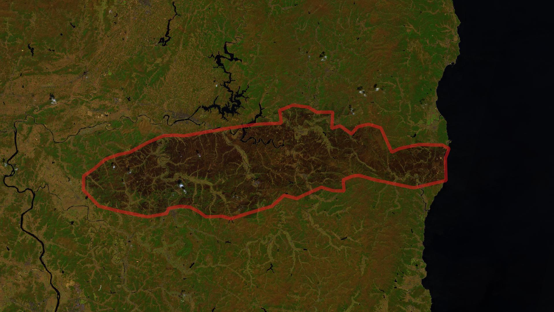
European Space Agency’s Sentinel-2 satellite provided crucial visual confirmation of the fire's extent. Using bands in SWIR (Short-Wave Infrared) and NIR (Near-Infrared), analysts were able to compare pre- and post-fire imagery to detect burned areas and assess environmental damage.
RGB imagery showed widespread discoloration, indicating areas where vegetation had been completely destroyed.
SWIR channels revealed deeply scorched ground, invisible to the naked eye.
NIR bands, which are sensitive to healthy vegetation, showed a stark decline in reflectance post-fire, confirming vegetation loss across a vast swath of land.
Comparison of NIR satellite images from March 14 and April 8, 2025, highlighting vegetation loss and burn scars caused by the wildfires in South Korea.
RGB satellite image comparison from March 14 and April 8, 2025, showing visible changes in the landscape after the wildfires in South Korea.
The burnt area stretched over 80 kilometers from inland Uiseong to the coast, engulfing forests, farmland, and cultural landmarks.
Human and Cultural Impact
Among the thousands of destroyed structures was Gounsa Temple, a 1,300-year-old heritage site, where a massive bronze bell lay cracked in the ruins. In the UNESCO-listed Hahoe Folk Village, fire retardants were dropped in a desperate attempt to protect its centuries-old thatched homes.
Tragically, at least 26 people were confirmed dead, with many more injured or displaced. Over 30,000 residents, many of them elderly, were forced to flee as the fires surged through rural communities.
Largest Burned Area in South Korean History
To put the scale into context:
2022's Uljin fire, previously considered a major disaster, burned just over 17,000 hectares.
The 10-year average for annual burned area (2015–2024) was approximately 4,000 hectares.
The March 2025 wildfires eclipsed this tenfold, burning more land in a single week than in the previous decade combined.
Authorities have linked the origin of the fire to an ancestral rite performed by a man in Uiseong County. He has been booked on charges of negligence. While wildfires are common in the region during spring, the speed and scale of these blazes have raised concerns about the growing impact of climate change on fire behavior.
Looking Ahead
South Korea's forest services and emergency management agencies are now turning to advanced remote sensing and climate modeling to prevent future disasters. As the climate continues to warm, experts fear such megafires may become a new norm, not just in South Korea, but around the globe.
We use cookies to run our website, analyze your use of our services, manage your online preferences & personalize ad content. By accepting our cookies, you'll get relevant content and social media features, personalized ads, and an enhanced browsing experience. To manage your choices, click "Cookie Settings." Necessary cookies are required for the core website functionality and cannot be rejected. For more information, see our Cookie Policy.
About cookies on this site
Cookies used on the site are categorized. Below you can allow or deny some or all of them, except for Necessary Cookies which are required to provide core website functionality. When categories that have been previously allowed are disabled, all cookies assigned to that category will be removed from your browser.
Some cookies are required to provide core functionality. The website won't function properly without these cookies and they are enabled by default and cannot be disabled.
Preference cookies enables the web site to remember information to customize how the web site looks or behaves for each user. This may include storing selected currency, region, language or color theme.
Analytical cookies help us improve our website by collecting and reporting information on its usage.
Marketing cookies are used to track visitors across websites to allow publishers to display relevant and engaging advertisements. By enabling marketing cookies, you grant permission for personalized advertising across various platforms.
The cookies in this category have not yet been categorized and the purpose may be unknown at this time.