🌍 Capture the world at 100% OFF! Use code ongeo100on 10 meters satellite image resolutions – limited time only! Higher resolution satellite images remain subject to payment.
🌍 Capture the world at 100% OFF! Use code ongeo100on 10 meters satellite image resolutions – limited time only! Higher resolution satellite images remain subject to payment.
Aerial photos as evidence in the case
2025-04-23
(Article updated:
2025-04-23
)
~ 5 min
In today's rapidly evolving legal landscape, technology is playing an increasingly pivotal role. One such innovation is the use of aerial and satellite imagery as legally admissible evidence. Companies like OnGeo Intelligence are at the forefront of this movement, offering remote sensing data that is transforming how courts assess property disputes, boundary disagreements, and civil claims.
High-Quality Satellite Imagery, Hassle-Free
Explore any location on Earth with precision. Order a detailed Satellite Imagery Report—no sign-ups, no contracts. Delivered in a clear PDF for instant insights.
Remote sensing refers to the process of gathering information about objects or areas from a distance, typically using satellites or aircraft. These tools do not make physical contact with the subject but instead rely on advanced sensors to collect accurate and timely data. This data has become a primary source of evidence in courtrooms, especially in property and civil disputes.
Let’s explore a few real-life-inspired stories that highlight how aerial photos from OnGeo Intelligence are being used to settle legal battles efficiently, objectively, and cost-effectively.
Real-Life Legal Cases Informed by Satellite Imagery
1. The Boundary Line Battle: A Tale of Two Neighbors
In a small village just outside Kraków, two families had lived side by side for over a decade. Everything was peaceful until one family erected a new fence—several meters inside what the neighbors claimed was their land. The dispute quickly escalated into a court case.
OnGeo Intelligence provided dated satellite images, clearly showing the previous location of the original boundary over time. With verified capture dates, precise geo-referencing, and expert interpretation, the court was able to determine the rightful boundary. The evidence was objective, retrospective, and impossible to manipulate.
Result? The fence was moved, and peace was restored—with no need for costly land surveys or prolonged legal wrangling.
2. Divorce Drama: Who Really Built the House?
In a bitter divorce case, the husband claimed that the family home was solely financed and built by him before the marriage. The wife argued otherwise, saying they constructed the house together during their marriage, making it shared property.
Aerial photos from OnGeo Intelligence turned the tide. A chronological sequence of satellite images showed a vacant plot turning into a construction site shortly after their wedding, with date-stamped visuals confirming the building timeline.
The judge ruled the house as joint property, citing the satellite photos as irrefutable evidence of cohabitation and joint development.
3. Road to Nowhere: When a Path Becomes a Legal Battlefield
In another case, two landowners clashed over a dirt road that ran between their plots. One claimed it was a private access road, while the other insisted it was a publicly used pathway for generations. The local municipality had no clear record of its legal status.
With historical satellite imagery from OnGeo Intelligence, experts reconstructed over 15 years of landscape changes. The analysis showed continuous use, visible tire tracks, and gradual widening of the path—clear signs of regular use by multiple parties.
The court recognized the road as an established right-of-way, thanks to the clarity and continuity captured in satellite images.
Legal experts and forensic analysts increasingly rely on remote sensing data for several reasons:
Verified timestamps: Images come with certified capture dates, making them trustworthy time-based evidence.
Large-area coverage: Ideal for examining properties, construction, deforestation, and infrastructure changes.
Retrospective analysis: Satellite archives allow experts to trace back changes over months or years.
Objectivity: Unlike witness statements, images can’t lie or forget.
Expert interpretation: OnGeo Intelligence provides professional reports with visual highlights and metrical data, boosting the legal weight of the evidence.
The Expert Advantage: OnGeo Intelligence
OnGeo Intelligence doesn’t just provide images—it delivers court-ready reports prepared by certified experts in geospatial analysis and remote sensing. These reports help lawyers and judges make informed decisions based on clear, visual, and quantifiable facts.
Whether it’s a land use conflict, unauthorized construction, or ownership dispute, aerial imagery can shorten trial times, reduce expert costs, and provide unbiased evidence that strengthens any case.
Conclusion: See the Bigger Picture, Literally
From property lines to partnership disputes, aerial photos from OnGeo Intelligence are changing how justice is delivered. The power of remote sensing lies in its ability to provide accurate, objective, and historical context—all from a bird’s-eye view.
If you're facing a legal conflict where location, timing, or land use are at the heart of the issue, it's time to consider satellite imagery not just as support—but as critical evidence. Because sometimes, seeing is not just believing—it’s winning.
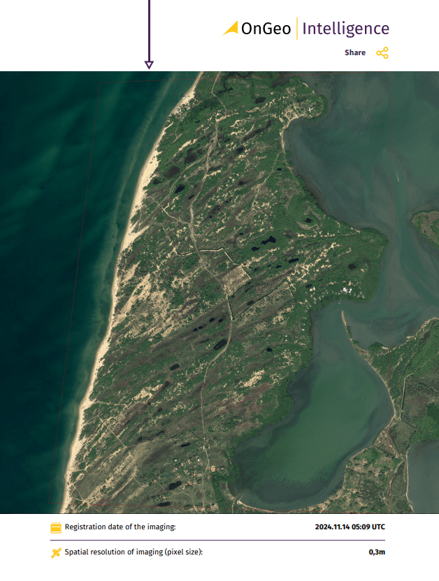
Sample report OnGeo Intelligence
How OnGeo Intelligence Satellite Imagery Report Supports Legal Investigations The OnGeo Intelligence Satellite Imagery Report is a powerful resource for legal professionals seeking high-resolution satellite images for their cases. It enables:
Historical Analysis: Compare past and present conditions to track changes.
Custom Imaging Solutions: Obtain tailored satellite images for specific cases.
Enhanced Legal Documentation: Strengthen legal arguments with irrefutable evidence.
We use cookies to run our website, analyze your use of our services, manage your online preferences & personalize ad content. By accepting our cookies, you'll get relevant content and social media features, personalized ads, and an enhanced browsing experience. To manage your choices, click "Cookie Settings." Necessary cookies are required for the core website functionality and cannot be rejected. For more information, see our Cookie Policy.
About cookies on this site
Cookies used on the site are categorized. Below you can allow or deny some or all of them, except for Necessary Cookies which are required to provide core website functionality. When categories that have been previously allowed are disabled, all cookies assigned to that category will be removed from your browser.
Some cookies are required to provide core functionality. The website won't function properly without these cookies and they are enabled by default and cannot be disabled.
Preference cookies enables the web site to remember information to customize how the web site looks or behaves for each user. This may include storing selected currency, region, language or color theme.
Analytical cookies help us improve our website by collecting and reporting information on its usage.
Marketing cookies are used to track visitors across websites to allow publishers to display relevant and engaging advertisements. By enabling marketing cookies, you grant permission for personalized advertising across various platforms.
The cookies in this category have not yet been categorized and the purpose may be unknown at this time.