🌍 Capture the world at 100% OFF! Use code ongeo100on 10 meters satellite image resolutions – limited time only! Higher resolution satellite images remain subject to payment.
🌍 Capture the world at 100% OFF! Use code ongeo100on 10 meters satellite image resolutions – limited time only! Higher resolution satellite images remain subject to payment.
Satellite Images from Sentinel-2 Available to Everyone
2024-09-03
(Article updated:
2024-11-29
)
~ 7 min
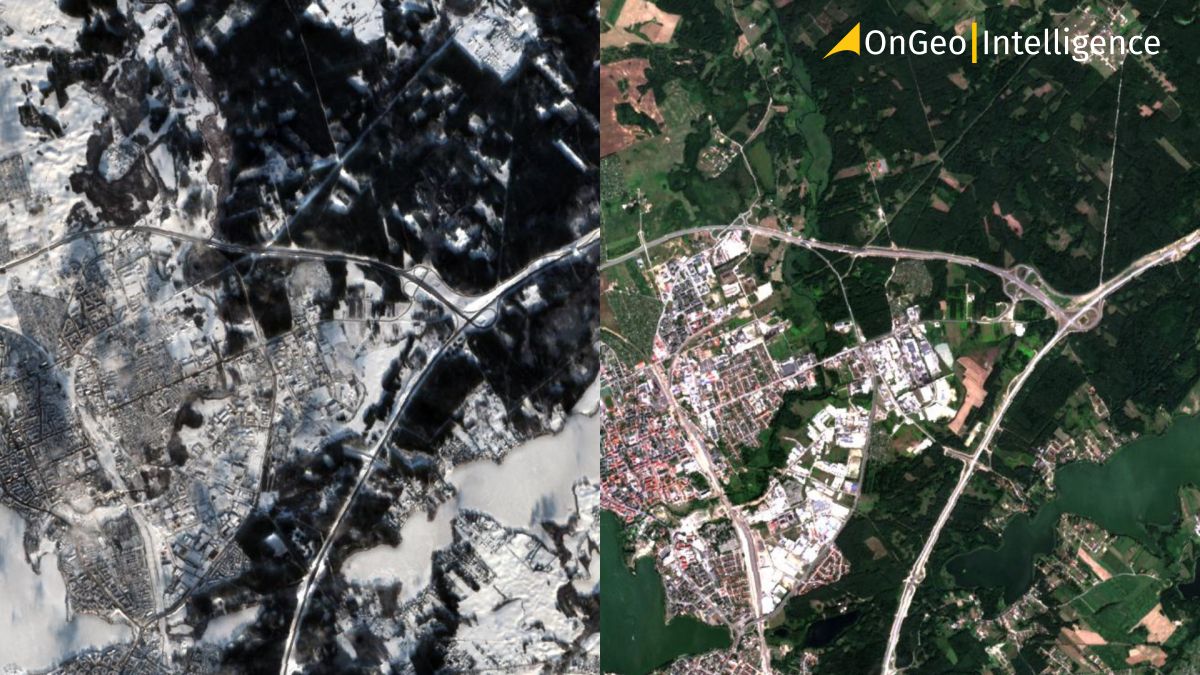
Satellite images are playing an increasingly important role in monitoring the state of our planet. With advancements in space technology, access to satellite imagery has become easier and more widespread than ever before. The Copernicus program, managed by the European Space Agency (ESA) and the European Commission, stands out as one of the most ambitious and innovative Earth observation initiatives in recent history. This program has developed a series of Sentinel satellites that provide global data on environmental conditions, making it a vital resource for various applications. Specifically, the Sentinel-2 satellites offer high-resolution images that are freely accessible to everyone, ensuring that individuals, organizations, and governments can utilize this valuable information.
High-Quality Satellite Imagery, Hassle-Free
Explore any location on Earth with precision. Order a detailed Satellite Imagery Report—no sign-ups, no contracts. Delivered in a clear PDF for instant insights.
The Sentinel-2 program includes two satellites: Sentinel-2A, which was launched in June 2015, and Sentinel-2B, which joined it in March 2017. Both satellites operate in sun-synchronous orbits, meaning they pass over the same point on Earth at the same time each day. This consistent timing allows for reliable data collection. Each satellite is equipped with a multispectral imaging instrument (MSI) that captures data in 13 different spectral bands, ranging from visible light to near-infrared. The spatial resolution of Sentinel-2 images varies from 10 to 60 meters, depending on the specific spectral band being utilized. These satellites can monitor large areas effectively, as each pass covers a 290-kilometer-wide swath. As a result, complete coverage of Earth's surface is achieved approximately every 5 days, allowing for regular data updates that are crucial for timely analysis.
Sentinel-2C Set to Launch on 4 September 2024
The Sentinel-2C satellite is scheduled for liftoff on 5 September 2024. This new addition to the Sentinel-2 mission will enhance the Copernicus Earth observation program by providing even more precise and frequent data on our planet's land and coastal areas. Sentinel-2C will continue the mission's legacy of high-resolution multispectral imaging, supporting applications such as agriculture, forestry, environmental monitoring, and disaster management. Its launch marks an important step in ensuring the continuity and expansion of the data provided by the Sentinel-2 satellite constellation.
Availability and Applications of Sentinel-2 Data
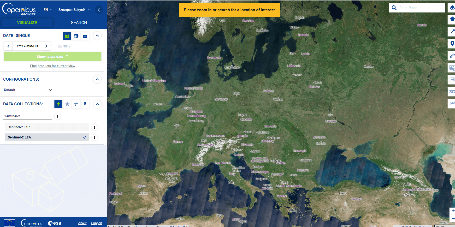
One of the key features of the Sentinel program is its open-access policy. Sentinel-2 satellite images are freely available to all users through platform, such as the Copernicus Open Access Hub. This open access ensures that anyone interested can easily obtain and utilize the data. The applications of this data are wide-ranging and impactful across multiple sectors. In agriculture, it is used to monitor crops, assess plant health, and plan harvests effectively.
Copernicus Open Acces Hub Platform
Farmers can make informed decisions based on the data provided by Sentinel-2, leading to improved yields and sustainable practices. In forestry, it supports resource management, monitors logging activities, and assesses fire damage, helping to protect vital ecosystems. In environmental protection, Sentinel-2 data is used to track water quality, soil erosion, and land use changes, providing essential insights for conservation efforts. Additionally, these images are instrumental in managing natural disasters such as floods or landslides, where timely data analysis aids in crisis response efforts, allowing for better preparedness and recovery strategies.
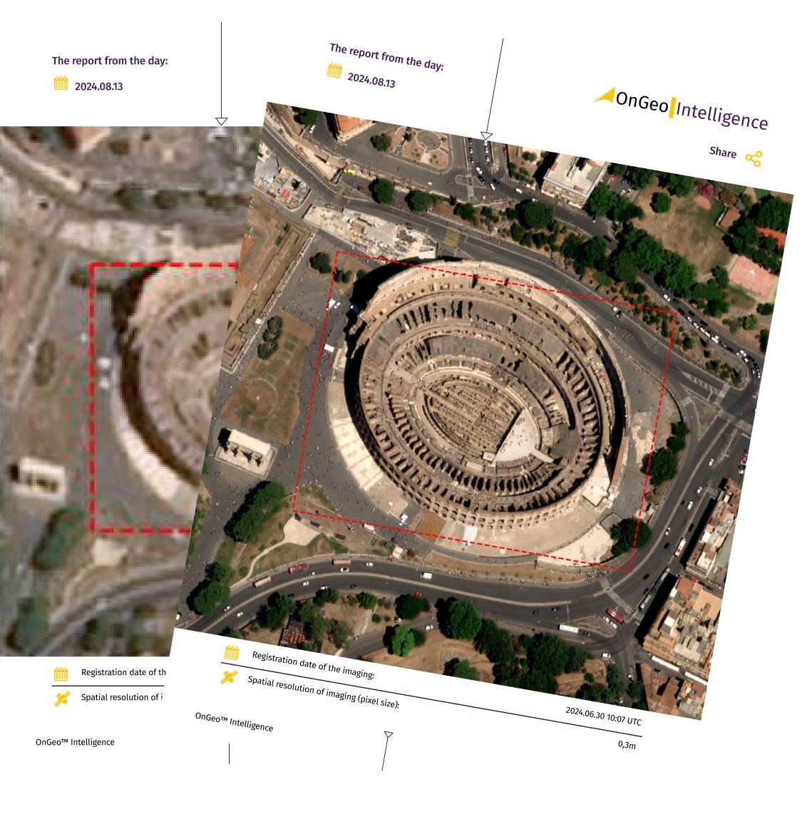
OnGeo™ Intelligence: Satellite Imagery Report Service
The OnGeo Intelligence Satellite Image Report service provides detailed satellite images tailored to the user’s selected area and time period. This comprehensive report includes a chronological arrangement of satellite imagery, offering clear insights into changes over time. Requested data will be delivered in a PDF document. Users can choose from a range of image resolutions to meet their specific needs, including:
Enjoy exceptional convenience and accessibility with the OnGeo™ Intelligence Satellite Imagery Report service – no account registration, contracts, or subscription fees required.
The versatility of Sentinel-2 data is evident in its numerous applications. For instance, urban planners utilize the imagery to monitor urban sprawl and assess land use changes over time. Environmental scientists rely on the data to study climate change impacts and track changes in vegetation cover. Furthermore, researchers in various fields can leverage the high-resolution images to conduct studies that require precise geographical information. The accessibility of Sentinel-2 data empowers a wide range of users, from local governments to global organizations, to make data-driven decisions that benefit society and the environment. By providing this valuable resource, the Sentinel-2 program exemplifies the principles of convenience, accessibility, and innovation, making it a cornerstone of modern Earth observation efforts.
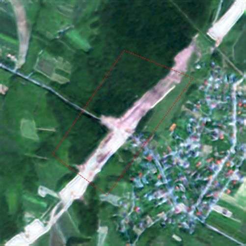
Urban Planning
Sentinel-2 satellite images enable precise mapping, which is essential for planning new construction projects effectively. These images provide a better understanding of various terrain features, existing infrastructure, and potential hazards such as floods or landslides. By utilizing this data, urban planners can make informed decisions that enhance the safety and sustainability of new developments. The detailed imagery allows for the identification of suitable locations for construction, ensuring that projects are not only viable but also environmentally responsible.
Sentinel-2 Satellite Imagery for Urban Planning
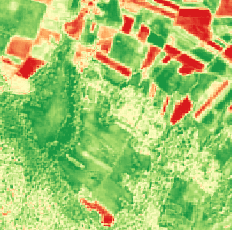
Monitoring Construction Progress
Sentinel-2 Satellite for Monitoring Construction Progress
Regular monitoring is crucial during the construction phase. Sentinel-2 images facilitate continuous tracking of landscape changes, helping to assess whether work is proceeding according to schedule. This ongoing observation is vital for identifying any delays or issues that may arise during the construction process. Image analysis algorithms can also automatically detect deviations from planned designs, allowing project managers to address problems promptly. By leveraging Sentinel-2 data, stakeholders can ensure that projects remain on track and within budget, ultimately leading to successful outcomes.
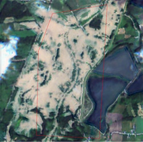
Environmental Impact Assessment
Every construction project inevitably affects the surrounding environment. Sentinel-2 data allows for the thorough assessment of these impacts, such as effects on vegetation or surface waters. This assessment is particularly important in the context of sustainable development and environmental protection. By analyzing changes in land cover and water bodies, planners can evaluate how construction activities may disrupt local ecosystems. This information is crucial for making adjustments to project plans to minimize negative environmental effects, ensuring that development aligns with sustainability goals.
Sentinel-2 Satellite for Environmental Impact Assessment
Crisis Management
Sentinel-2 for Crisis Management
In the event of crises such as floods, earthquakes, or other natural disasters, satellite images provide valuable information on the extent of damage. This information is essential for helping coordinate rescue and recovery efforts effectively. Sentinel-2 images can quickly reveal the areas most affected by disasters, allowing emergency responders to prioritize their actions. By utilizing this data, authorities can make informed decisions that enhance the efficiency of disaster response, ultimately saving lives and resources.
Challenges and the Future
Despite its enormous potential, using Sentinel-2 data comes with certain challenges. Analyzing large volumes of satellite data requires appropriate IT infrastructure and advanced analytical tools. Additionally, to fully leverage the data's potential, specialists must be trained in remote sensing and spatial data analysis. This need for skilled professionals can be a barrier to widespread adoption. However, the future of the Sentinel-2 program looks promising, with further technological advancements and expanded capabilities planned. These developments will enable even more precise monitoring of our planet. In the long term, Sentinel-2 data will play a crucial role in sustainable natural resource management and in addressing global challenges such as climate change.
Conclusion
Sentinel-2 satellites provide an exceptional tool for monitoring the environment on a global scale. With open access to data, these images are available to everyone, supporting a wide range of applications across various fields. Looking ahead, this data will play an increasingly important role in promoting sustainable development. The Copernicus program offers significant opportunities to better understand and manage our planet, and it is worth taking full advantage of these resources. By harnessing the power of Sentinel-2 data, we can work towards a more sustainable and resilient future for our communities and the environment.
We use cookies to run our website, analyze your use of our services, manage your online preferences & personalize ad content. By accepting our cookies, you'll get relevant content and social media features, personalized ads, and an enhanced browsing experience. To manage your choices, click "Cookie Settings." Necessary cookies are required for the core website functionality and cannot be rejected. For more information, see our Cookie Policy.
About cookies on this site
Cookies used on the site are categorized. Below you can allow or deny some or all of them, except for Necessary Cookies which are required to provide core website functionality. When categories that have been previously allowed are disabled, all cookies assigned to that category will be removed from your browser.
Some cookies are required to provide core functionality. The website won't function properly without these cookies and they are enabled by default and cannot be disabled.
Preference cookies enables the web site to remember information to customize how the web site looks or behaves for each user. This may include storing selected currency, region, language or color theme.
Analytical cookies help us improve our website by collecting and reporting information on its usage.
Marketing cookies are used to track visitors across websites to allow publishers to display relevant and engaging advertisements. By enabling marketing cookies, you grant permission for personalized advertising across various platforms.
The cookies in this category have not yet been categorized and the purpose may be unknown at this time.