🌍 Capture the world at 100% OFF! Use code ongeo100on 10 meters satellite image resolutions – limited time only! Higher resolution satellite images remain subject to payment.
🌍 Capture the world at 100% OFF! Use code ongeo100on 10 meters satellite image resolutions – limited time only! Higher resolution satellite images remain subject to payment.
Off-nadir imagery: its use cases and limitations
2025-02-27
(Article updated:
2025-02-27
)
~ 4 min
In satellite Earth Observation (EO), off-nadir refers to the angle between a satellite's direct downward line of sight – known as nadir – and its actual viewing direction toward a target on Earth's surface. An off-nadir angle of 0° indicates the satellite is looking straight down, while larger angles mean the sensor is tilted away from this vertical position.
High-Quality Satellite Imagery, Hassle-Free
Explore any location on Earth with precision. Order a detailed Satellite Imagery Report—no sign-ups, no contracts. Delivered in a clear PDF for instant insights.
Satellites are equipped with sensors that can adjust their viewing angles to capture images of areas not directly beneath them. This capability allows for increased revisit rates, enabling satellites to image specific locations more frequently without waiting for a direct overpass. By tilting their sensors, satellites can also acquire stereoscopic images from different angles, which are useful for creating 3D models of the Earth's surface.
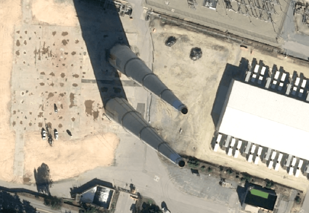
1. Geometric distortions: Tilting the sensor introduces geometric distortions, causing tall structures to appear to lean away from the image center. This effect, known as the "building-lean" phenomenon, can complicate accurate mapping and analysis.
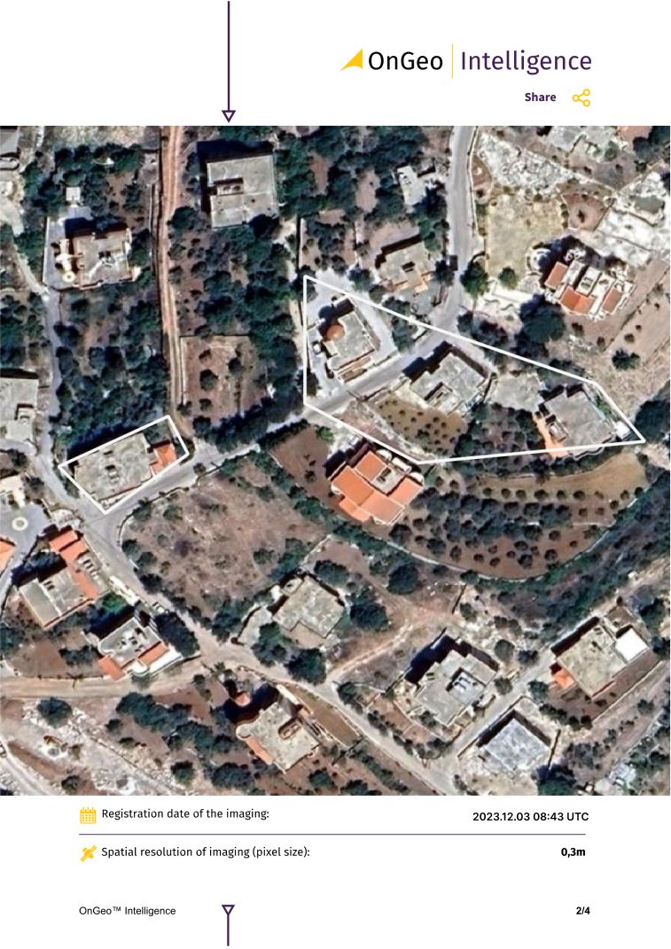
2. Reduced spatial resolution: As the off-nadir angle increases, the distance between the satellite and the target area grows, leading to a decrease in image resolution. For instance, an image captured at a 0° off-nadir angle might have a resolution of 30 cm, whereas at a 30° angle, the resolution could degrade to around 40 cm.
3. Increased atmospheric interference: Observing the Earth's surface at higher off-nadir angles means the sensor's line of sight passes through more of the atmosphere, which can introduce additional scattering and absorption effects, potentially degrading image quality.
4. Shadowing effects: Off-nadir viewing can result in longer shadows, especially in areas with tall structures or varied terrain. These shadows can obscure details and affect the interpretation of the imagery.
Example of off-nadir satellite imagery showcasing an angled perspective
Example of off-nadir satellite imagery showcasing an angled perspective
Positive applications of off-nadir imagery:
Despite all of their limitations off-nadir satellite images are useful in many areas. Examples?
Earthquakes & landslides: – By combining multiple off-nadir images from different times, analysts can measure ground displacement and damage assessment in affected areas.
Stereo imaging: Off-nadir images taken from two or more angles allow for the generation of digital elevation models (DEMs), which are essential for 3D city models.
Building height estimation: The "leaning" effect seen in off-nadir images can actually be useful – it helps in calculating skyscraper heights and mapping shadow patterns.
OnGeo Intelligence Satellite Imagery Report
The OnGeo-Intelligence Report leverages high-resolution imagery from a range of advanced satellites, providing reliable and accurate data for industries requiring precise asbestos monitoring solutions.
With OnGeo Intelligence, accessing satellite imagery has never been easier. The user-friendly Satellite Imagery Report offers high-quality data in a streamlined PDF format, eliminating the need for registration or long-term commitments. Users worldwide can obtain detailed imagery and actionable insights tailored to their area of interest, enabling efficient decision-making and planning across various industries. This report simplifies the process of utilizing satellite data for accurate analysis and effective strategy development.
The feasible off-nadir angle varies depending on the satellite's design and mission objectives. For optical imagery, a typical maximum off-nadir angle is around 30 degrees. However, some satellites are capable of capturing images at greater angles. For example, the GeoEye-1 satellite can image up to 60 degrees off-nadir, allowing for more flexible imaging options at the cost of increased distortions and reduced resolution.
In summary, while off-nadir imaging enhances a satellite's ability to monitor specific areas more frequently and from multiple perspectives, it also introduces certain limitations such as geometric distortions, reduced resolution and increased atmospheric interference. The choice of off-nadir angle must balance the need for timely and comprehensive data with the acceptable level of image quality degradation.
We use cookies to run our website, analyze your use of our services, manage your online preferences & personalize ad content. By accepting our cookies, you'll get relevant content and social media features, personalized ads, and an enhanced browsing experience. To manage your choices, click "Cookie Settings." Necessary cookies are required for the core website functionality and cannot be rejected. For more information, see our Cookie Policy.
About cookies on this site
Cookies used on the site are categorized. Below you can allow or deny some or all of them, except for Necessary Cookies which are required to provide core website functionality. When categories that have been previously allowed are disabled, all cookies assigned to that category will be removed from your browser.
Some cookies are required to provide core functionality. The website won't function properly without these cookies and they are enabled by default and cannot be disabled.
Preference cookies enables the web site to remember information to customize how the web site looks or behaves for each user. This may include storing selected currency, region, language or color theme.
Analytical cookies help us improve our website by collecting and reporting information on its usage.
Marketing cookies are used to track visitors across websites to allow publishers to display relevant and engaging advertisements. By enabling marketing cookies, you grant permission for personalized advertising across various platforms.
The cookies in this category have not yet been categorized and the purpose may be unknown at this time.