🌍 Capture the world at 100% OFF! Use code ongeo100on 10 meters satellite image resolutions – limited time only! Higher resolution satellite images remain subject to payment.
🌍 Capture the world at 100% OFF! Use code ongeo100on 10 meters satellite image resolutions – limited time only! Higher resolution satellite images remain subject to payment.
Seeing Through the Smoke: How SWIR Satellite Imagery Detects Hidden Wildfires from Orbit
2025-03-26
(Article updated:
2025-03-26
)
~ 5 min
In the era of escalating climate threats, wildfires have become more frequent, more intense and more unpredictable. As flames spread across forests and communities, heavy smoke often blankets the landscape, rendering traditional Earth Observation tools ineffective. In this challenging context, satellites equipped with short-wave infrared (SWIR) sensors offer a powerful advantage: the ability to detect fire through smoke, assess damage in real time and support emergency response with actionable intelligence.
High-Quality Satellite Imagery, Hassle-Free
Explore any location on Earth with precision. Order a detailed Satellite Imagery Report—no sign-ups, no contracts. Delivered in a clear PDF for instant insights.
Short-wave infrared, or SWIR, refers to a portion of the electromagnetic spectrum typically ranging from 1.0 to 2.5 micrometers. This spectral window lies beyond the range of human vision and even beyond the near-infrared sensors commonly used in remote sensing. What makes SWIR particularly valuable is its ability to penetrate smoke and thin cloud cover. Unlike visible or NIR imagery, which can be obstructed by dense atmospheric particles, SWIR captures thermal signatures and material differences on the ground with clarity. It is especially sensitive to temperature variations, vegetation moisture levels and surface changes caused by combustion.
SWIR’s Role in Wildfire Detection and Assessment
During a wildfire event, SWIR imagery is indispensable. It can reveal the location of active fire fronts obscured by thick smoke, distinguish between hot ash and open flames and identify smoldering zones that may reignite. Beyond immediate detection, SWIR data also enables post-fire assessment by mapping burn scars and estimating the severity of damage to ecosystems. This information is critical for land managers, insurance assessors, and humanitarian responders who need accurate, high-resolution data under time pressure.
Maxar's WorldView-3: A High-Resolution SWIR Solution
Among the most capable satellites providing SWIR data is Maxar Technologies’ WorldView-3. Launched in 2014, WorldView-3 is the cutting-edge satellite offering eight SWIR bands at a ground resolution of 3.7 meters. This level of detail is exceptional in the SWIR domain and allows for precise fire detection even in complex terrains. The satellite's agility and frequent revisit make it ideal for monitoring rapidly evolving wildfire situations.
SWIR in Action: California Wildfires 2018–2021
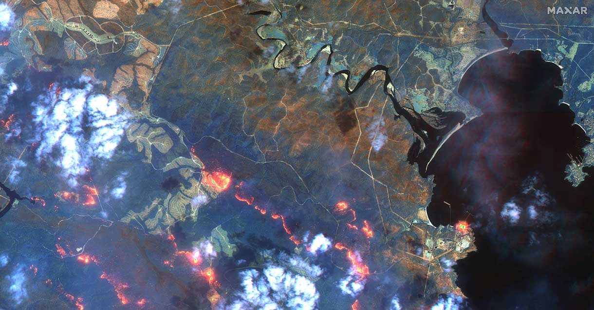
One of the most widely cited uses of WorldView-3 in wildfire management occurred during the catastrophic fires in California between 2018 and 2021, including the Camp Fire and Dixie Fire. In these cases, SWIR imagery from WorldView-3 allowed analysts to track the movement of fire lines, even as smoke choked the atmosphere and made visible-spectrum observations unusable. The satellite's data helped emergency services prioritize evacuation routes, assess structural damage and plan containment strategies based on up-to-date fire progression maps. High-resolution SWIR images also supported media coverage and post-disaster analysis by providing clear views of affected areas long before the smoke had cleared.
Interactive SWIR Imagery Map of California Wildfires Source: MaxarSatellite image of the California Wildfires on August 19, 2021 Source: NOAA-NASA Suomi NPP satelliteSatellite image of the California Wildfires on August 19, 2021 Source: Operational Land Imager (OLI) on Landsat 8
Sentinel-2: A Publicly Available SWIR Resource
While commercial platforms like WorldView-3 offer unparalleled resolution, publicly available missions such as the European Sentinel-2 have also proven essential in wildfire monitoring. Sentinel-2 carries SWIR bands (Band 11 and 12) at a spatial resolution of 20 meters, which are widely used to detect active fires, map burn scars and estimate post-fire vegetation stress. One of the key advantages of Sentinel-2 is its frequent revisit time – as short as five days globally – combined with its open-access policy. This makes it an invaluable source of data for governments, researchers and environmental agencies around the world. Using indices like the Normalized Burn Ratio (NBR), analysts can quantify burn severity and monitor ecosystem recovery over time. Although the resolution is coarser than commercial satellites, Sentinel-2’s consistency, multispectral range and global coverage make it a cornerstone of operational fire mapping workflows.
SWIR for Improved Fire Monitoring
In Australia’s Black Summer of 2019–2020, when vast portions of the continent were engulfed in flames, SWIR sensors again proved invaluable. Sentinel-2 satellites, which offer SWIR bands at 20-meter resolution, were used alongside commercial assets like WorldView-3 to monitor burned areas, estimate fuel moisture loss and evaluate the regeneration of vegetation weeks after the fires subsided. Though Sentinel-2 lacks the spatial resolution of WorldView-3, recent advancements in artificial intelligence have made it possible to enhance such data. In a 2019 study published on arXiv, researchers demonstrated how convolutional neural networks (CNNs) could be used to generate super-resolved SWIR imagery from Sentinel-2 data, effectively doubling its detail and improving fire detection at scale.
Satellite image of the Fireline south of Eden, 2020 Source: Maxar
SWIR’s Contribution to Volcanic Hazard Management
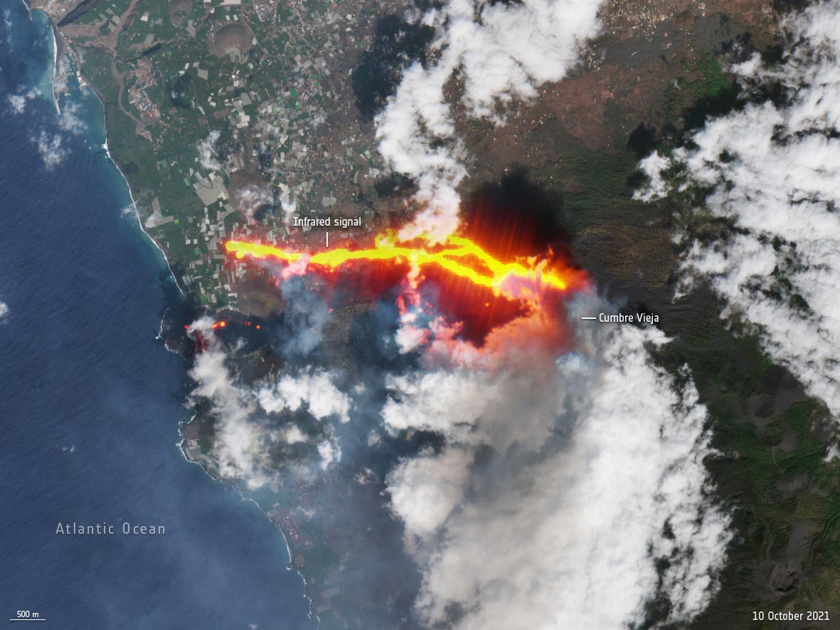
SWIR technology also played a role during the 2021 eruption of the Cumbre Vieja volcano on La Palma in the Canary Islands. While the primary hazard was volcanic, the surrounding region experienced secondary fires caused by falling ash and lava. SWIR imagery was used to separate thermal anomalies from active fires, providing emergency teams with crucial information about where human intervention was needed most.
Satellite image of the Cumbre Vieja volcano on La Palma October 10, 2021 Source: Copernicus Sentinel-2
Limitations and Future of SWIR in Fire Response
Despite these successes, there are limitations. SWIR performance can still be affected by thick cloud decks or extreme weather conditions and the high cost of commercial imagery can restrict access in some regions. Nonetheless, as satellite technology advances and the frequency of extreme fire events increases, the demand for SWIR data in wildfire management is expected to grow.
Conclusion: SWIR’s Growing Importance in Earth Observation
For Earth observation professionals, researchers and crisis responders, the integration of SWIR sensors into operational monitoring frameworks represents a critical leap forward. Whether through ultra-high-resolution data from WorldView-3 or through AI-enhanced imagery from public satellites like Sentinel-2, SWIR is reshaping how we see and respond to fire on a warming planet.
We use cookies to run our website, analyze your use of our services, manage your online preferences & personalize ad content. By accepting our cookies, you'll get relevant content and social media features, personalized ads, and an enhanced browsing experience. To manage your choices, click "Cookie Settings." Necessary cookies are required for the core website functionality and cannot be rejected. For more information, see our Cookie Policy.
About cookies on this site
Cookies used on the site are categorized. Below you can allow or deny some or all of them, except for Necessary Cookies which are required to provide core website functionality. When categories that have been previously allowed are disabled, all cookies assigned to that category will be removed from your browser.
Some cookies are required to provide core functionality. The website won't function properly without these cookies and they are enabled by default and cannot be disabled.
Preference cookies enables the web site to remember information to customize how the web site looks or behaves for each user. This may include storing selected currency, region, language or color theme.
Analytical cookies help us improve our website by collecting and reporting information on its usage.
Marketing cookies are used to track visitors across websites to allow publishers to display relevant and engaging advertisements. By enabling marketing cookies, you grant permission for personalized advertising across various platforms.
The cookies in this category have not yet been categorized and the purpose may be unknown at this time.