🌍 Capture the world at 100% OFF! Use code ongeo100on 10 meters satellite image resolutions – limited time only! Higher resolution satellite images remain subject to payment.
🌍 Capture the world at 100% OFF! Use code ongeo100on 10 meters satellite image resolutions – limited time only! Higher resolution satellite images remain subject to payment.
Step-by-Step Guide to Downloading Free Sentinel Data for Your GIS Projects
2025-04-23
(Article updated:
2025-04-23
)
~ 6 min
Introduction: Simplifying Access to Free Satellite Data
Satellite imagery is an essential resource for GIS projects, enabling users to analyze land use, monitor environmental changes, and make data-driven decisions. While platforms like the Copernicus Browser provide raw satellite data in formats such as GeoTIFF, processing these files can be complex and time-consuming. Alternatively, OnGeo Intelligence offers ready-to-use reports that simplify the process by delivering enhanced Sentinel imagery in a user-friendly format.
This guide will explain how to download Sentinel data via Copernicus Browser and highlight the advantages of using OnGeo Intelligence Satellite Imagery Reports, which include additional insights like remote sensing indices and comprehensive data packages.
High-Quality Satellite Imagery, Hassle-Free
Explore any location on Earth with precision. Order a detailed Satellite Imagery Report—no sign-ups, no contracts. Delivered in a clear PDF for instant insights.
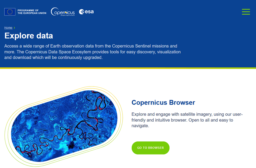
The Copernicus Data Space Ecosystem is the official platform for accessing free Sentinel imagery under the European Space Agency’s Copernicus program. It provides raw satellite data for various applications, but users must process this data manually to extract meaningful insights.
Step-by-Step Download Free Sentinel Data Instructions:
Unlogged users can view data but cannot download it.
The Copernicus Data Space Ecosystem was launched in 2023, replacing the previously existing Copernicus Open Access Hub.
Copernicus Data Space Ecosystem
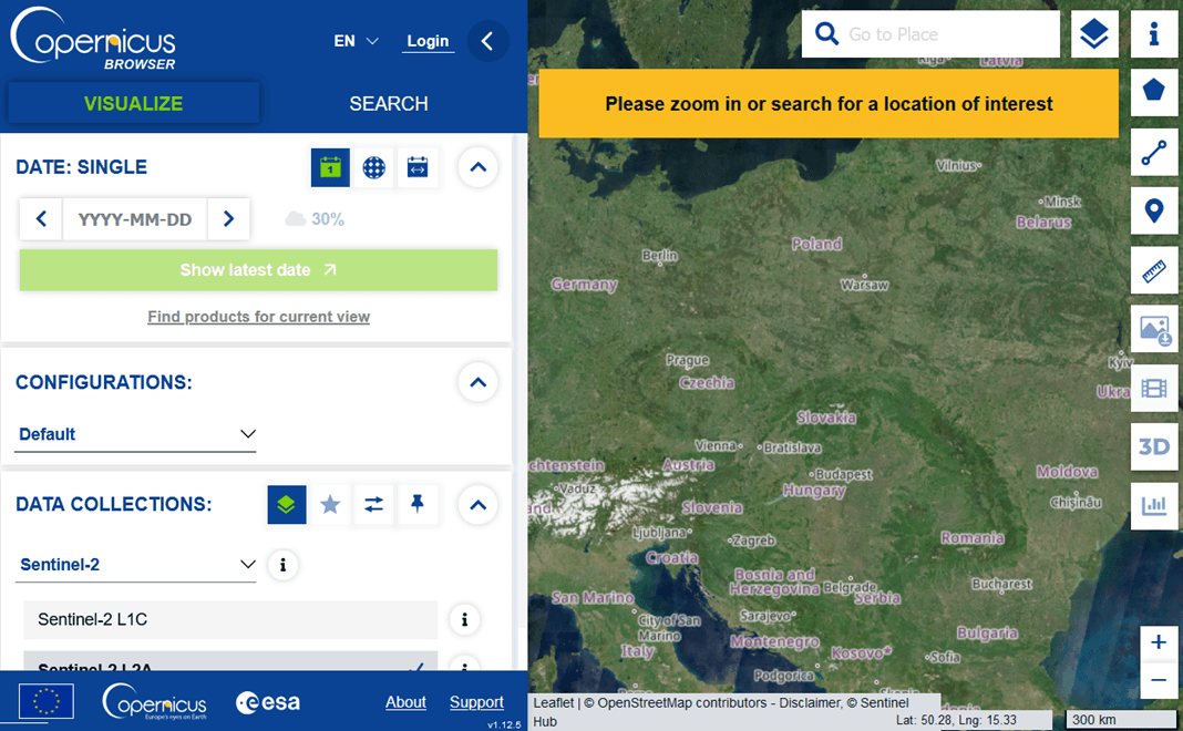
2. Go to: Copernicus browser
Access to Sentinelconstellation satelliteproducts is provided by the Copernicus Browser application (CB). The application allows you to search and download ready-made products without any fees
Copernicus Browser application
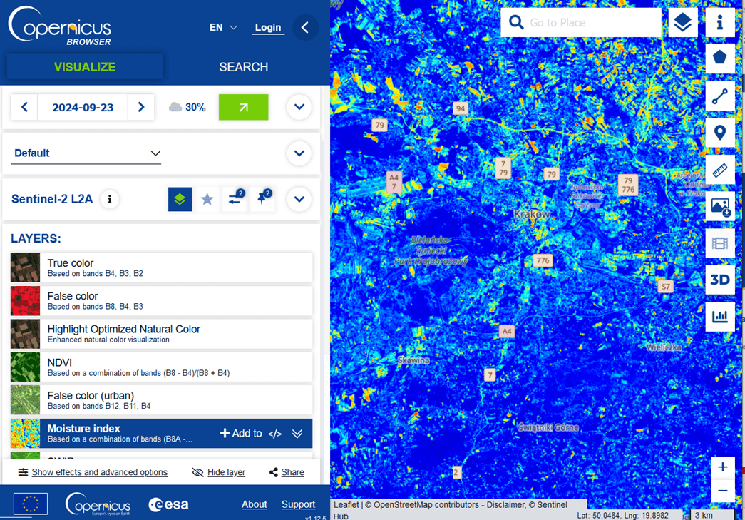
3. Copernicus browser – data visualization
The new Copernicus browser functionality is the visualization of images and their processing. To view, select visualization tab and time relevance date.
Then you can present subsequent processing by selecting products from the list.
Copernicus browser - visualize
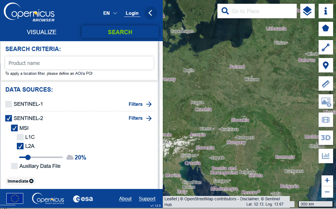
4. Copernicus browser – data search
The basic functionality of CB is searching for images and their processing by location. To browse, select the search tab, then product type, % cloudiness and time interval of the photos.
Copernicus browser - search imagery
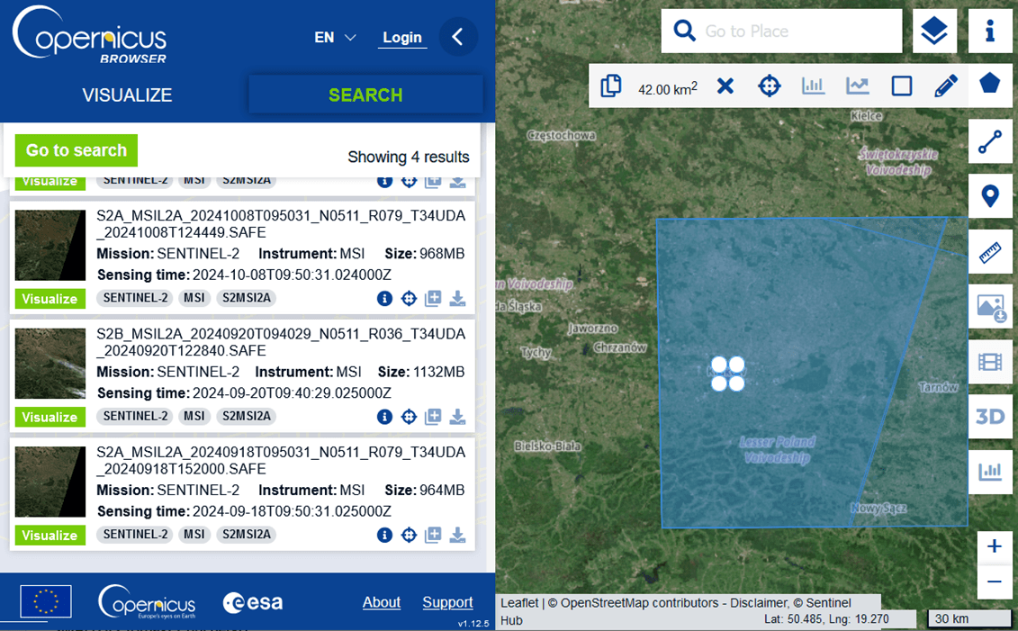
5. Copernicus browser – data search
An area of interest (AOI) is defined by the extent of the displayed map or an area drawn with tools.
Copernicus browser draw area of interest
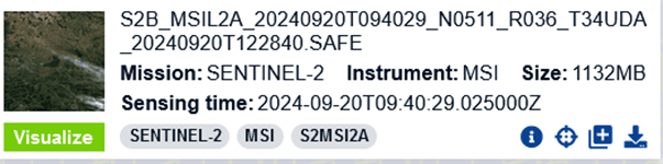
6. Copernicus browser – data download
Downloads are initiated by pointing at the down arrow icon on the product description panel. For users who are not logged in, the download function is disabled.
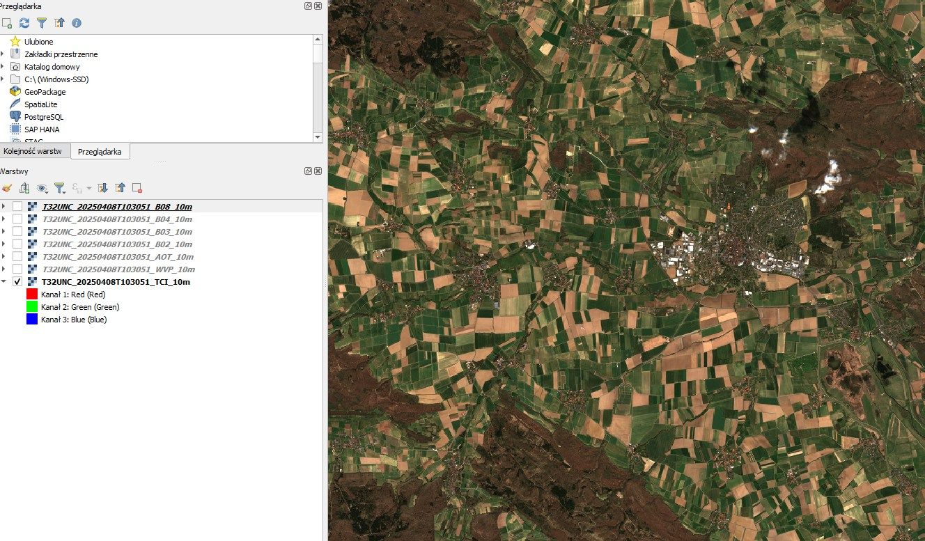
Add selected datasets to your cart and download them in GeoTIFF format, which is widely supported by GIS platforms like QGIS and ArcGIS.
Each dataset typically includes metadata files that describe the acquisition date, resolution, and spectral bands available.
Satellite Imagery sentinel 2 in QGIS
What Happens After Downloading GeoTIFF Files?
Once you’ve downloaded GeoTIFF files from Copernicus Browser:
File Structure: The GeoTIFF files contain raw satellite imagery divided into spectral bands (e.g., visible light, near-infrared, short-wave infrared). These bands must be processed individually or combined based on your analysis needs.
Software Requirements: To open GeoTIFF files, you’ll need GIS software such as QGIS or ArcGIS. These tools allow you to visualize, analyze, and manipulate satellite data using raster processing techniques.
Manual Processing: Users must apply formulas (e.g., NDVI or NDWI) to calculate remote sensing indices manually. This requires knowledge of spectral band combinations and GIS workflows.
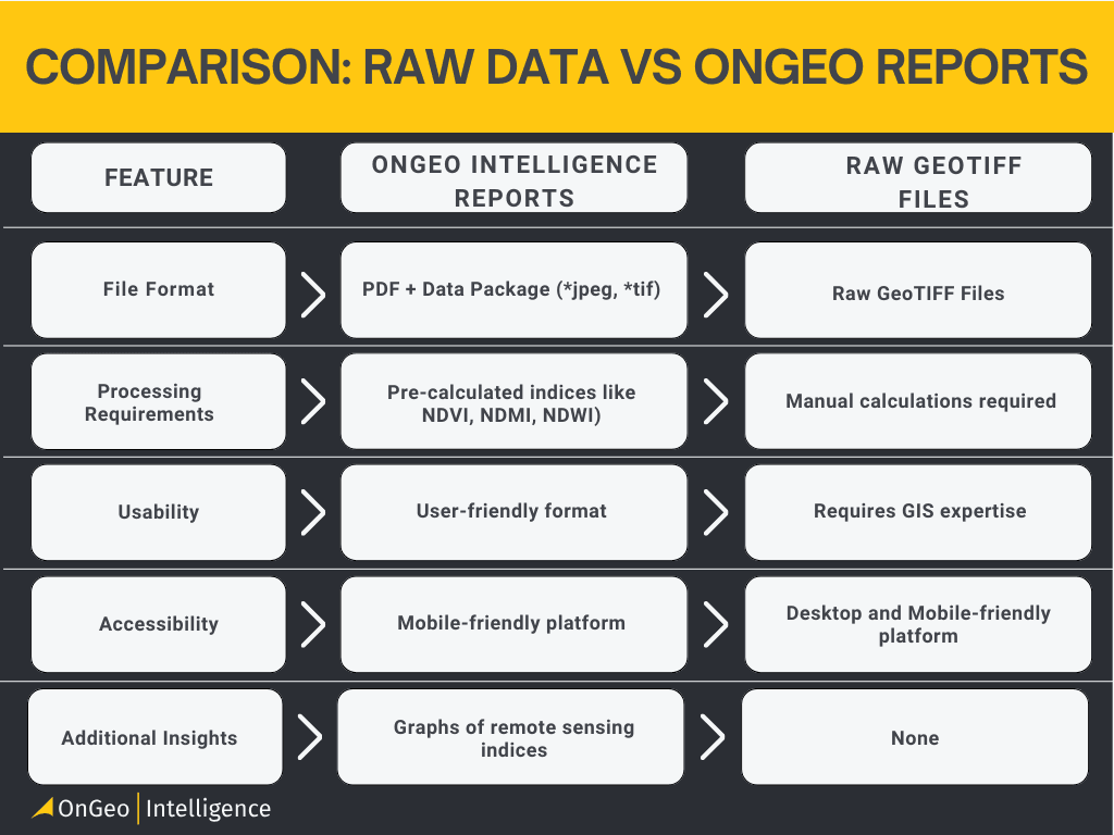
While GeoTIFF files offer flexibility for advanced users, the manual processing involved can be challenging for those unfamiliar with GIS tools or remote sensing techniques.
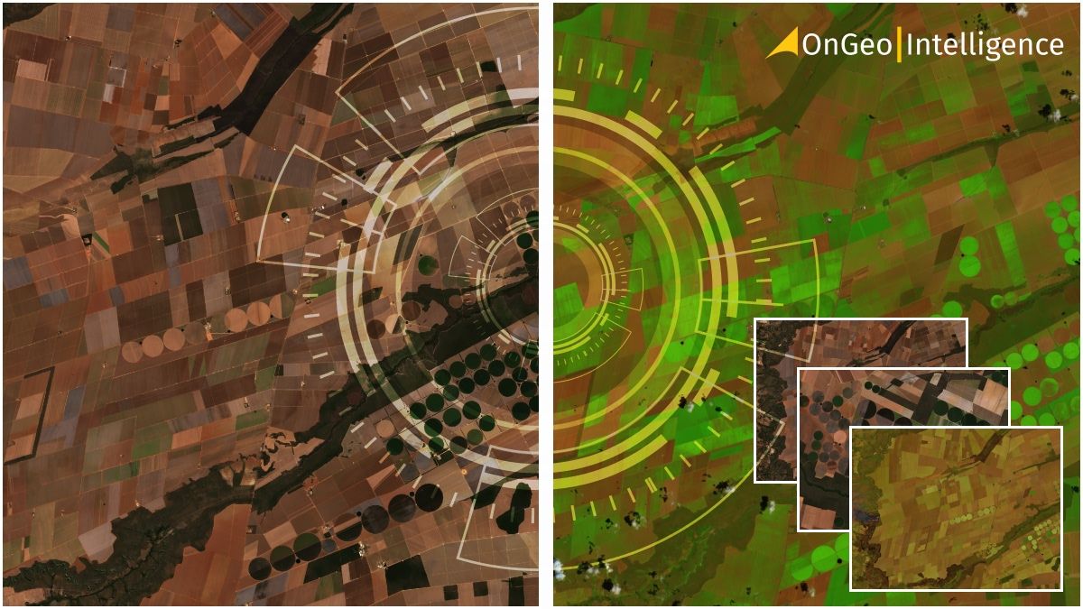
Accessing Ready-to-Use Reports via OnGeo Intelligence
For users seeking a simpler solution, OnGeo Intelligence Satellite Imagery Reports provide Sentinel imagery in an accessible format without requiring manual processing. These reports are ideal for GIS projects of all scales and include additional features that enhance usability.
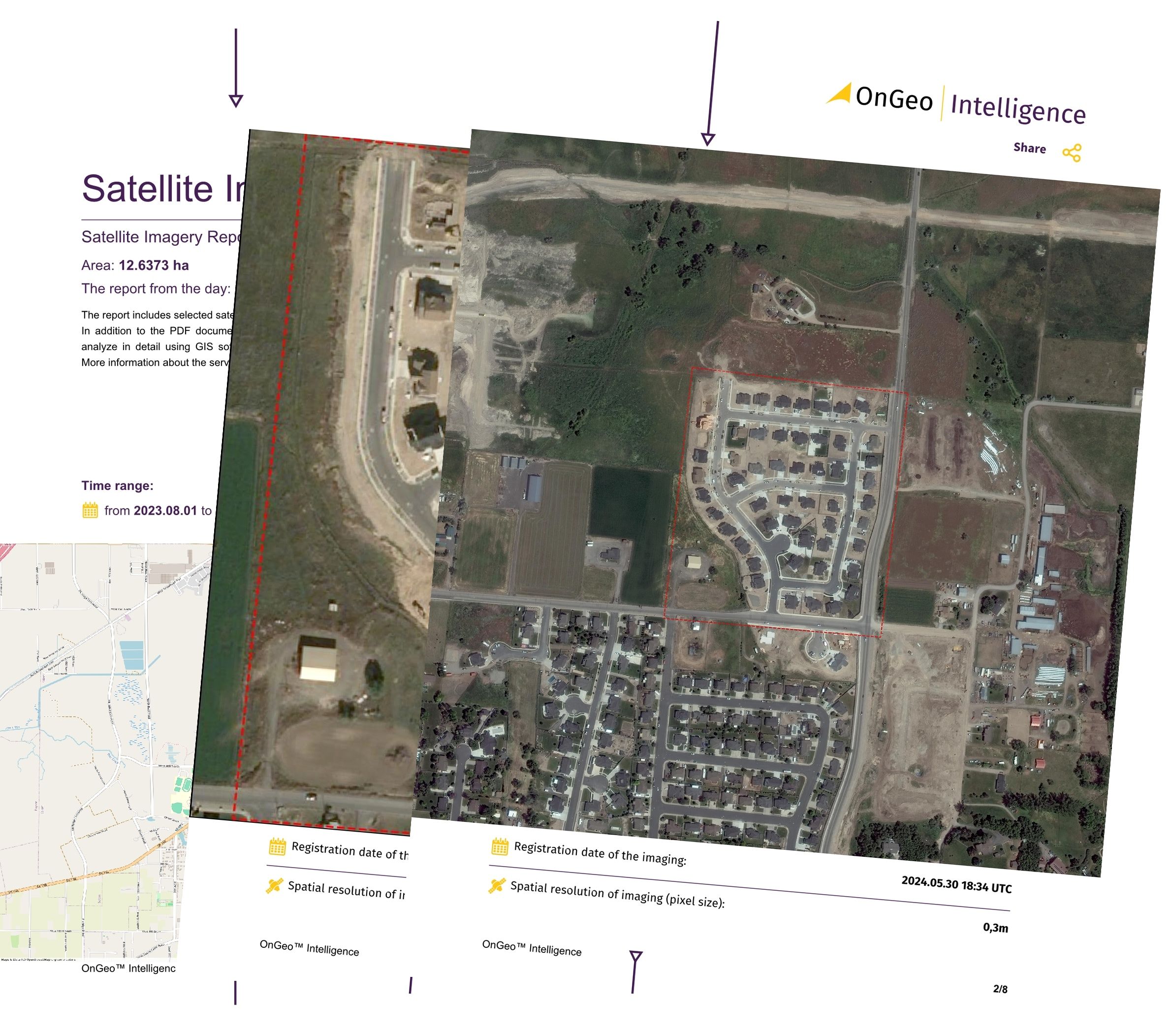
Satellite Imagery Satellite Report OnGeo Intelligence example
Key Benefits of OnGeo Intelligence Reports:
Free Access with Code "ongeo100": Generate reports featuring 10-meter resolution images enhanced to 2.5 meters at no cost during this promotion period.
Comprehensive Data Package: Includes visible bands along with near-infrared (NIR) and short-wave infrared (SWIR) channels for advanced spatial analysis in GIS software.
Remote Sensing Indices: A dedicated PDF report provides graphs illustrating changes in NDVI (Normalized Difference Vegetation Index), NDWI (Normalized Difference Water Index), and NDMI (Normalized Difference Moisture Index) over time.
User-Friendly Format: Receive organized PDF files with chronological scenes and additional insights tailored to your selected area.
Mobile-Friendly Platform: Order reports directly from your smartphone—no need for specialized software.
To see what an OnGeo report looks like, check out this Sample Report.
How to Generate a Free Report Using OnGeo Intelligence
Step by step report OnGeo Intelligence
Using the Satellite Imagery Report service is simple and accessible for everyone:
Select location and time period Pinpoint the area you want to analyze on an interactive map and specify the date range.
Search archives The platform automatically locates satellite images available for your selected area and period.
Add images to your cart Browse through the results and add your preferred scenes to your cart – all from your smartphone or desktop device.
Enter code ongeo100 at checkout Apply the code during checkout to unlock free access to your report with 10 m resolution images enhanced using AI technology to 2.5 m per pixel- providing a sharper image and better distinction of smaller objects than standard 10m imagery.
Receive your report via email Low-resolution reports are delivered within minutes, while high-resolution reports are available within 48 hours.
For step-by-step guidance, watch this Instructional Video
Why Choose OnGeo Intelligence Over Copernicus Browser?
While platforms like Copernicus Browser provide raw datasets in GeoTIFF format, processing these files requires technical expertise and additional software tools. In contrast, OnGeo Intelligence simplifies access by delivering actionable insights in a ready-to-use format:
Conclusion: Choose Your Ideal Method
Whether you prefer downloading datasets from platforms like Copernicus Browser or opting for ready-to-use reports from OnGeo Intelligence, accessing free satellite data has never been easier.
For those seeking simplicity and actionable insights without technical hurdles, OnGeo Intelligence offers a seamless solution with its Satellite Imagery Report service—perfect for GIS projects of all scales.
Don’t miss this opportunity—use code "ongeo100" today and experience how easy it is to integrate satellite imagery into your workflow!
We use cookies to run our website, analyze your use of our services, manage your online preferences & personalize ad content. By accepting our cookies, you'll get relevant content and social media features, personalized ads, and an enhanced browsing experience. To manage your choices, click "Cookie Settings." Necessary cookies are required for the core website functionality and cannot be rejected. For more information, see our Cookie Policy.
About cookies on this site
Cookies used on the site are categorized. Below you can allow or deny some or all of them, except for Necessary Cookies which are required to provide core website functionality. When categories that have been previously allowed are disabled, all cookies assigned to that category will be removed from your browser.
Some cookies are required to provide core functionality. The website won't function properly without these cookies and they are enabled by default and cannot be disabled.
Preference cookies enables the web site to remember information to customize how the web site looks or behaves for each user. This may include storing selected currency, region, language or color theme.
Analytical cookies help us improve our website by collecting and reporting information on its usage.
Marketing cookies are used to track visitors across websites to allow publishers to display relevant and engaging advertisements. By enabling marketing cookies, you grant permission for personalized advertising across various platforms.
The cookies in this category have not yet been categorized and the purpose may be unknown at this time.