High-Quality Satellite Map of Istanbul: Free Download
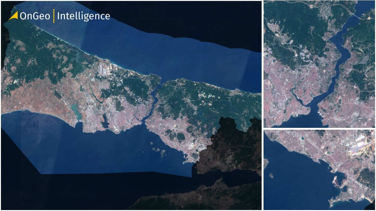
Istanbul is a city where continents meet — a unique blend of Europe and Asia, history and modernity, land and sea. Now, you can experience Istanbul from above with our satellite map, created using up-to-date 2024 imagery from Sentinel-2. This map is free to download, ready for printing, and ideal for anyone who needs accurate geographic insight into one of the world’s most iconic cities.
Download High Quality Satellite Map of Istanbul
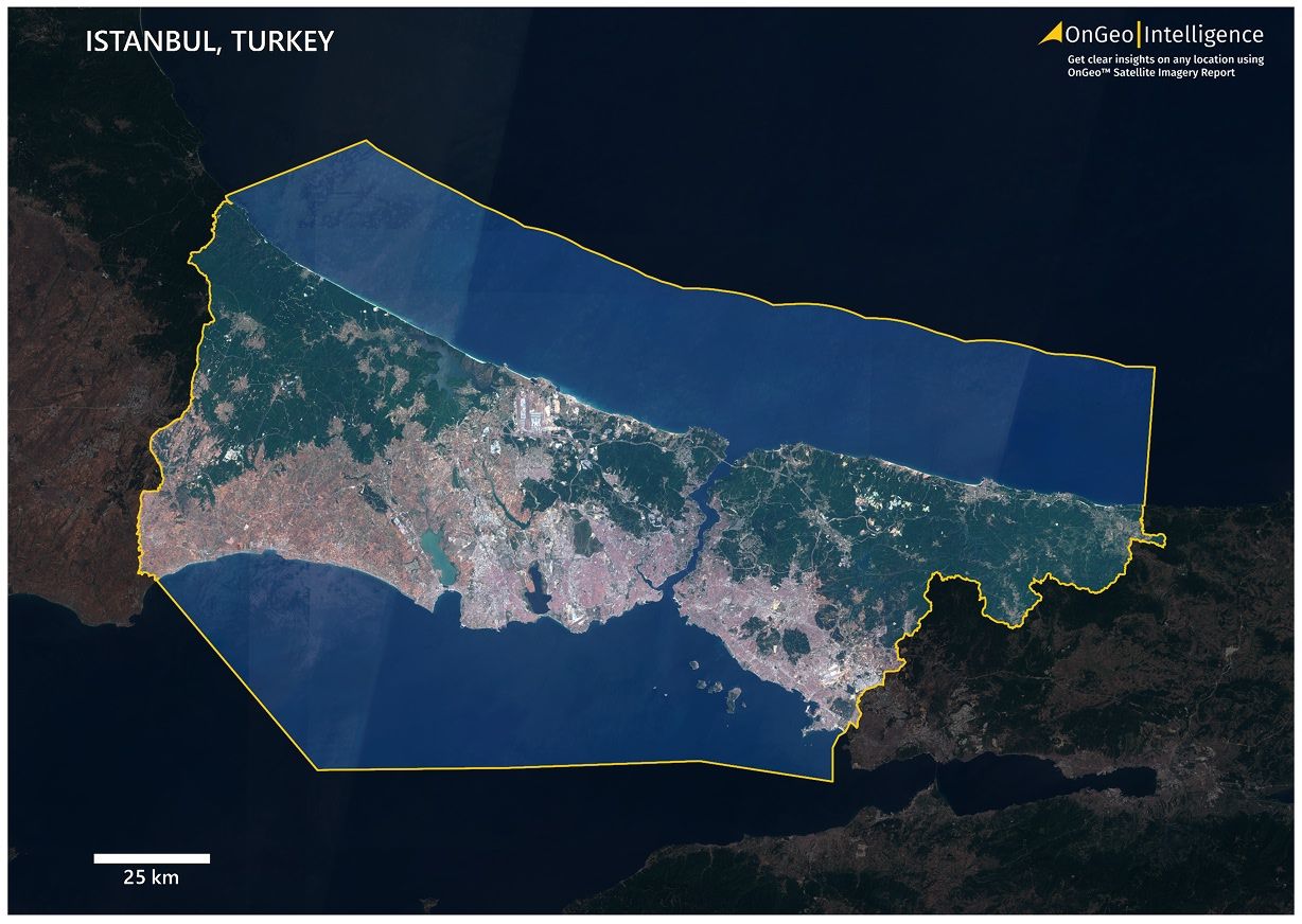
We’ve prepared a professional-quality satellite map of Istanbul in a convenient A3 PDF format. It shows the entire metropolitan area in natural color and includes key geographic and infrastructural details.
📥 [Download High Quality Satellite Map of Istanbul – PDF, 17.9 MB]
Istabul Satellite Map Thumbnail Low Quality
What the Satellite Map of Istanbul Contains
This printable map gives you a precise and visually clear view of Istanbul and its surrounding environment, including:
The full extent of the urban area and built-up zones
Major roadways, bridges, and railway infrastructure
The Bosphorus Strait, Golden Horn, and other water bodies
Forests, green zones, and industrial regions
City boundary highlighted in yellow
Darkened outer region to increase contrast and focus
A visible scale bar and map title (Istanbul, Turkey)
Satellite Map of Istanbul – Tailored to Your Needs
Looking for a satellite map of Istanbul in another format, scale, or with custom boundaries?
📧 Get in touch: contact@ongeo-intelligence.com
We create personalized satellite maps for professionals and institutions worldwide.
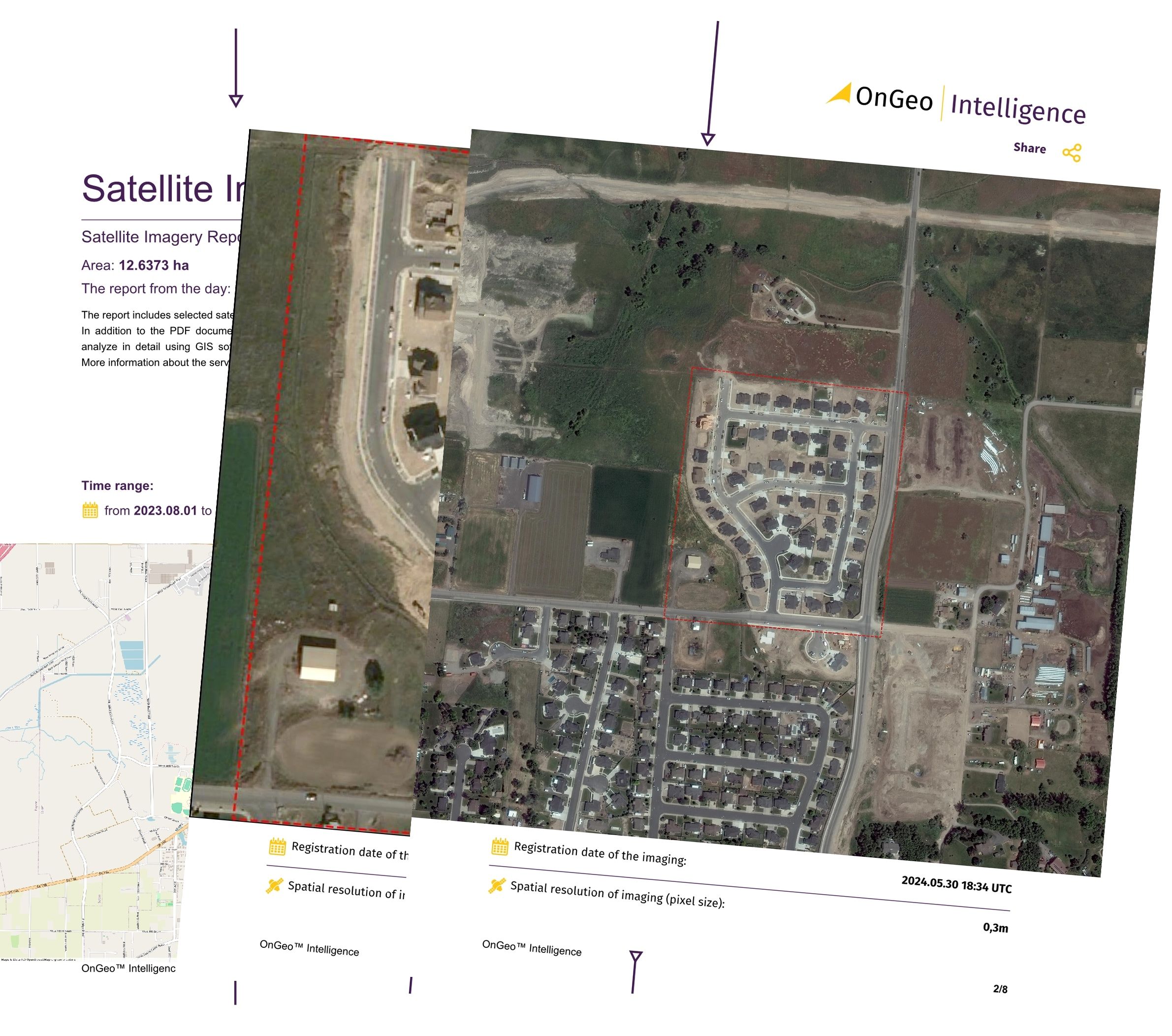
OnGeo Satellite Imagery Report – Instant Map of Your Property
Looking for recent satellite imagery of a specific location or property?
With the OnGeo Satellite Imagery Report, you can instantly generate custom high-resolution satellite maps of any area in just a few clicks — no registration required.
🛰 Key Features:
Access very high-resolution imagery instantly
Delivered in PDF format — perfect for sharing and printing
No login or software needed — works on your phone or PC
Ideal for real estate, agriculture, insurance, environment, and more
Who Created the Map and How It Was Made
The satellite map of Istanbul was developed by OnGeo Intelligence, a team of experts in geospatial data processing and remote sensing. Using high-resolution RGB imagery from the Sentinel-2 satellite, we processed the data into a visual product that balances geographic precision with readability.
Satellite maps are indispensable tools in:
Urban planning and development
Environmental monitoring
Real estate and tourism
Education and research
Our mission is to make these tools accessible, accurate, and visually compelling for everyone.
How to Use the Satellite Map of Istanbul
This map is free for both personal and professional use. It can be used in:
🎓Educational and academic work
🌳Environmental and urban studies
🏤Real estate and location analysis
📝Presentations and reports
📣Creative and promotional materials
🔎Personal research and exploration
You may modify and publish the map freely, with only two conditions:
⚠️Do not remove the OnGeo Intelligence logo or map branding
📝If shared publicly, include attribution: Source: OnGeo-Intelligence.com
Explore More City Maps Soon
This Istanbul map is part of our growing global series. Upcoming cities include Ankara, Dubai, Rome, and many more.
📌 Stay updated at OnGeo-Intelligence.com
Related articles
- Download the Satellite Map of Mexico City – Free Printable PDF
- Download the Satellite Map of New York City – Free Printable PDF
- How to Get a Current Satellite Map of My Property
- Essential Tips for Interpreting Satellite Imagery Like a Pro
- Free Satellite Imagery Providers: Compare and Choose the Best Option