From Maxar to Vantor: A New Era in Satellite Earth Observation and Geospatial Intelligence
The retirement of the Maxar brand marks a significant shift in the satellite Earth Observation landscape. With Vantor emerging as a standalone geospatial intelligence company, the industry sees a sharper focus on integrated, AI-powered solutions and real-time spatial awareness.
Maxar's Legacy in Earth Observation
For years, Maxar was one of the most recognizable names in the satellite Earth Observation (EO) sector, known for its high-resolution imagery and strong presence in both government and commercial markets. But as of October 2025, the Maxar name has officially been retired, giving way to two specialized entities: Vantor, focusing on end-to-end geospatial intelligence, and Lanteris, dedicated to satellite manufacturing and space infrastructure.
This strategic rebranding follows Maxar’s 2023 acquisition by private equity firm Advent International in a 6.4 billion dollar deal. Then the company’s operations were split in two. The newest move reflects a broader trend in the EO market: value is increasingly derived not from raw satellite imagery but from the ability to deliver real-time, AI-powered intelligence across multiple domains.
Vantor: A New Geospatial Intelligence Leader
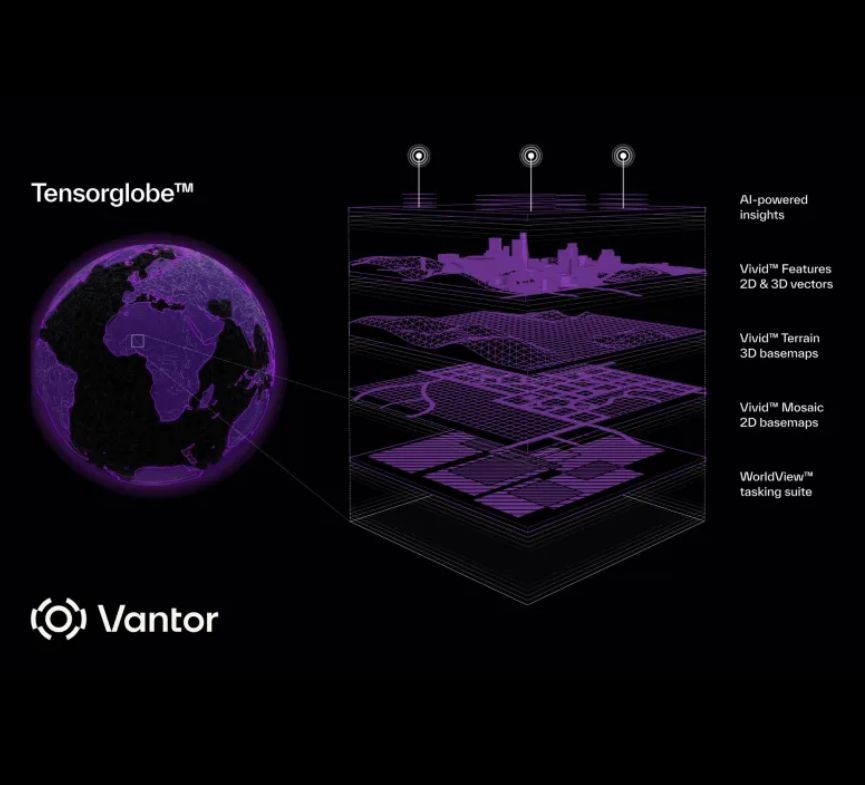
Formerly known as Maxar Intelligence, Vantor now positions itself as a next-generation spatial intelligence provider, offering full-spectrum EO solutions that go beyond traditional imagery. At the core of this transformation is Tensorglobe, the company’s flagship AI-powered platform that fuses sensor data from satellites, aerial assets and ground systems into a unified, continuously updated 3D model of the Earth.
Tensorglobe consists of three main components: Coretex, which manages satellite tasking and collection planning; Forge, which fuses multisource data into a detailed digital twin of the globe; and Nexus, which delivers secure access and analytics for decision-makers.
Tensorglobe: The Core of Vantor’s Innovation
This approach reflects the changing needs of modern defense and commercial operators who require multi-domain awareness, not just static snapshots. By integrating Earth observation data with advanced analytics and autonomy-ready infrastructure, Vantor supports applications such as threat monitoring, navigation without GPS and command and control for military operations.
Vantor continues to operate the WorldView satellite constellation, including the recently launched WorldView Legion satellites, while also partnering with external providers like Umbra and Satellogic to build a virtual, heterogeneous EO network. Customers include U.S. defense and intelligence agencies, commercial partners and international governments seeking sovereign surveillance capabilities.
Lanteris: Powering Vantor’s Satellite Capabilities
Lanteris, the other half of Maxar’s legacy, plays a critical role in enabling Vantor’s operations by focusing on cutting-edge satellite manufacturing and advanced space infrastructure. Lanteris designs and builds the next-generation WorldView Legion satellites, which provide Vantor with high-resolution imagery and enhanced revisit rates for near real-time monitoring. By leveraging Lanteris’ expertise in satellite technology, Vantor ensures a steady supply of state-of-the-art spacecraft tailored to its geospatial intelligence needs. Lanteris also pioneers innovations in satellite modularity and scalability, supporting Vantor’s vision of a flexible, heterogeneous EO network that integrates data from multiple sources for comprehensive global coverage.
Vantor’s Historical Roots
The heritage of Vantor traces back to DigitalGlobe, one of the pioneers of commercial high-resolution EO, later acquired by Maxar in 2017. The Vantor brand reflects a pivot away from a pure imagery provider to a platform-based company enabling autonomous systems, real-time situational awareness and decision-grade intelligence at scale.
Despite the corporate transition, existing contracts, satellite tasking capabilities and core services remain uninterrupted. What changes is the company’s focus - from delivering pixels to delivering actionable insights.
Vantor’s emergence as a specialized EO and spatial intelligence player highlights several key trends: the increasing availability of satellite imagery is pushing companies to focus on value-added services; AI, data fusion and 3D modeling are becoming core differentiators; and government clients, especially in defense and intelligence, increasingly demand integrated, end-to-end solutions that connect data across space, air and ground.
The Future of Earth Observation
As the satellite EO market continues to evolve, Vantor’s model may serve as a blueprint for the future, where intelligence, not imagery, drives value.
If you're working with satellite data - whether in defense, environmental monitoring, infrastructure or autonomy - the Vantor rebrand is more than just a name change. It's a signal that the future of Earth Observation lies in intelligent systems, not static pixels.