
Why Metadata Is Essential in Satellite Earth Observation
In satellite Earth Observation, data is more than pixels. The real value lies in metadata - the information that describes when, where, how and in what circumstances the image was taken. The metadata makes satellite images meaningful, allowing for reliable analysis, time-series comparisons and integration across platforms and sensors. Understanding dataset metadata is crucial for extracting valuable insights from Earth Observation data.
What is metadata in EO?
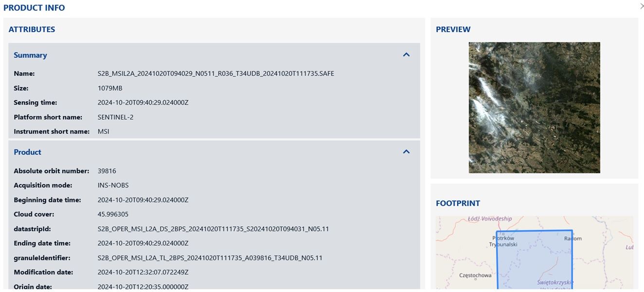
Metadata is the structured information that accompanies every satellite image. It includes various metadata fields such as the time of acquisition, satellite and sensor name, image resolution, solar angles, cloud cover, geolocation accuracy, spectral bands and calibration constants. Without these dataset properties, an image is just a picture - not geospatial data. Different metadata types serve various purposes in Earth Observation analysis.
Why metadata matters?
Accurate Geolocation The metadata ensures that each pixel is accurately geolocated. Metadata fields like image corner coordinates, the projection system and accuracy indicators such as CE90 (Circular Error 90%) and RMSE (Root Mean Square Error), used in Maxar products, are crucial when aligning satellite data with maps, vector layers or other imagery. This spatial information is essential for precise mapping and analysis.
Temporal Context The acquisition timestamp in a metadata file allows analysts to compare images over time. In platforms like Plex-Earth Timeviews, this enables visual tracking of changes across specific areas and projects, making time-based EO applications possible. The metadata query capabilities of such platforms facilitate efficient temporal analysis.
Sun and Sensor Geometry Metadata includes solar angles (sun elevation and azimuth) and viewing geometry (off-nadir angle). These values affect shadowing, brightness and reflectance, and are required for accurate atmospheric correction, especially when analyzing vegetation or urban areas. Understanding these dataset properties is crucial for accurate interpretation of satellite imagery.
Scene Quality and Cloud Cover Both Airbus and Maxar metadata files include cloud cover percentage. This allows users to automatically filter out cloudy or low-quality scenes through metadata query, which saves processing time and ensures cleaner datasets for further analysis. The metadata helps in selecting the most suitable images for a given application.
Spectral and Radiometric Calibration For physical analysis - such as calculating NDVI or measuring surface reflectance - raw digital numbers must be converted into radiance or reflectance. Source metadata from satellites like WorldView-3 includes absolute calibration factors and effective bandwidths per spectral band, which are essential for that conversion. Without these pixel values have no physical meaning.
A typical WorldView-3 metadata file includes for example:
• Acquisition time
• Sun azimuth and elevation
• Sensor name and resolution (GSD)
• Spectral band names and wavelengths
• Calibration factors per band
• Geolocation accuracy (CE90, RMSE)
• Cloud cover percentage
This metadata enables precise mapping, scientific measurements and integration with data from other sources, such as Sentinel-2 or drone surveys. The metadata paths in these files allow easy access to specific information needed for various analyses.
Metadata is the backbone of modern EO workflows. It provides transparency and allows users to trace every image back to its source conditions. Whether you're monitoring forests, tracking urban growth, or analyzing post-disaster areas, reliable metadata documents ensure the data you use is scientifically sound and spatially correct.
Practical Applications of Metadata in EO
Beyond technical accuracy, metadata directly impacts how Earth Observation data is applied across industries. In agriculture, dataset metadata enables precise crop monitoring by ensuring vegetation indices are calibrated and comparable over time. In urban planning, geolocation accuracy and temporal context support tracking of infrastructure development and land use change. In disaster response, cloud cover information and acquisition timestamps allow rapid selection of the clearest, most recent imagery for decision-making.
Even in climate research, spectral and radiometric calibration factors are crucial for long-term environmental monitoring. The open data cube concept, which relies heavily on well-structured metadata, has revolutionized the way we handle and analyze large volumes of Earth Observation data. ODC metadata and EO3 metadata standards have been developed to ensure interoperability and ease of use across different platforms and applications.
Without metadata, these applications would lack the reliability and scientific rigor required for actionable insights. The datacube metadata approach allows for efficient storage, retrieval, and analysis of vast amounts of satellite imagery, making it possible to process and interpret Earth Observation data at unprecedented scales.
In conclusion, metadata is not just an add-on to satellite imagery; it is an integral part of the Earth Observation ecosystem. From ensuring accurate geolocation to enabling complex time-series analyses, the metadata plays a crucial role in extracting meaningful insights from satellite data. As Earth Observation technologies continue to advance, the importance of comprehensive and standardized metadata will only grow, further cementing its place as an essential component in understanding and monitoring our planet.
Related articles
- From Space to Shore: How Earth Observation Satellites Help Monitor Water Quality
- Airbus Satellite Imagery for Earth Observation
- What Is Temporal Resolution in Earth Observation?
- How Satellite Imagery Works: From Space to Your Screen
- Understanding DEM, DTM and DSM in Satellite Earth Observation
- Satellite Imagery: Definition and Applications in 2026