🌍 Capture the world at 100% OFF! Use code ongeo100on 10 meters satellite image resolutions – limited time only! Higher resolution satellite images remain subject to payment.
🌍 Capture the world at 100% OFF! Use code ongeo100on 10 meters satellite image resolutions – limited time only! Higher resolution satellite images remain subject to payment.
The Power of Satellite Stereo Imagery
2025-03-14
(Article updated:
2025-03-14
)
~ 4 min
Modern Earth observation is being transformed by innovative technologies, and one of the most groundbreaking is satellite stereo imagery. This technique enables the creation of 3D models of our planet, unlocking new opportunities in urban planning, environmental protection, and the energy sector. But how does it work, and what are its key benefits? Let’s explore!
High-Quality Satellite Imagery, Hassle-Free
Explore any location on Earth with precision. Order a detailed Satellite Imagery Report—no sign-ups, no contracts. Delivered in a clear PDF for instant insights.
What Is Satellite Stereo Imaging and How Does It Work?
In the ever-evolving field of Earth Observation, one technology has stood out as a game-changer: satellite stereo imagery. By capturing images of the same location from different angles, this technique enables the creation of three-dimensional models of the Earth's surface, unlocking valuable insights for industries ranging from urban planning to environmental conservation. As satellites orbit above us, they provide more than just static pictures – they offer a dynamic, layered perspective that reshapes how we understand our planet.
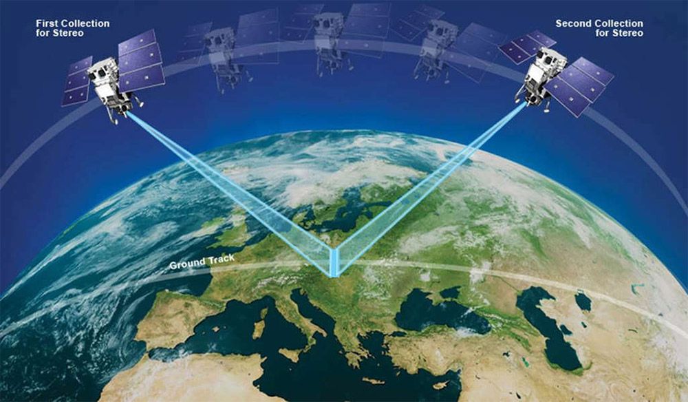
Types of Stereo Imaging: In-Track, Cross-Track, and Tri-Stereo
Unlike traditional satellite imagery, which captures flat, two-dimensional views, stereo imagery allows for depth perception. This is achieved through multiple acquisition methods.
In-track stereo imaging involves a single satellite taking two images within seconds of each other, ensuring minimal changes in lighting and environmental conditions.
Cross-track stereo imaging, on the other hand, captures images from different satellite passes, providing flexibility but introducing potential discrepancies due to time differences.
Tri-stereo imaging, enhances the process by adding a near-vertical shot, improving detail and reducing occlusions, particularly in complex terrains such as mountains and dense urban environments.
In-track stereo collection mode. The sensor collects two shots (45-90 seconds apart) of the same location by adjusting its camera. Source: Maxar.
Creating Digital Elevation Models (DEMs) with Stereo Imagery
One of the primary applications of stereo satellite imagery is the generation of Digital Elevation Models (DEMs), which serve as 3D representations of the Earth's surface. DEMs are indispensable for topographic mapping, flood modeling and infrastructure development, allowing planners and engineers to make informed decisions. For example, in disaster-prone areas, accurate elevation data helps predict flood zones and optimize emergency response strategies. Similarly, in urban development, stereo imagery aids in the precise measurement of building heights, ensuring compliance with zoning regulations and facilitating smart city planning.
How Stereo Technology Supports Forestry and Agriculture
Beyond infrastructure, stereo imagery is revolutionizing vegetation management. Forestry experts use it to estimate tree heights and biomass, a critical factor in assessing carbon storage and monitoring deforestation. By analyzing the structure and density of vegetation, conservationists can better track changes in ecosystems and implement sustainable land-use policies. In agriculture, stereo data supports precision farming by evaluating crop growth and detecting variations in terrain that affect irrigation and soil erosion.
Stereo Imaging in Mining and the Energy Sector
The mining and energy sectors also benefit immensely from this technology. Extracting minerals or constructing energy infrastructure requires precise terrain assessments. With stereo imagery, geologists and engineers can identify potential excavation sites, assess slope stability, and minimize environmental impact. Renewable energy projects, such as wind and solar farms, use elevation models derived from stereo data to optimize placement and efficiency, ensuring maximum exposure to natural resources.
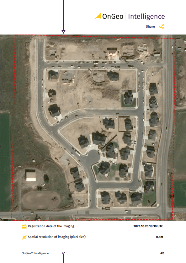
Sample Satellite Imagery Report
At OnGeo Intelligence, we offer fast and easy access to high-resolution satellite imagery reports, available globally. Whether for monitoring your property, supporting legal proceedings, or other applications, our service delivers precise satellite data quickly.
Key features include:
Global Reach: Request imagery from anywhere on Earth.
No Hassle: No account needed—simply select your area of interest.
High-Resolution Data: Get detailed imagery perfect for various uses.
PDF Format: Receive easy-to-read reports in minutes.
Experience quick, reliable satellite imagery reports today on OnGeo-Intelligence.com—no long-term commitments, just the data you need.
The Future of 3D Imaging: Advancements and Emerging Applications
From cityscapes to remote wilderness, satellite stereo imagery offers a detailed, three-dimensional view of our world. Its applications continue to expand, influencing industries, governments and researchers alike. As advancements in satellite technology drive higher-resolution and more frequent stereo captures, the potential for 3D Earth observation will only grow. Whether mapping the tallest skyscrapers, monitoring forests, or planning sustainable infrastructure, this powerful tool is redefining how we see and interact with our planet.
We use cookies to run our website, analyze your use of our services, manage your online preferences & personalize ad content. By accepting our cookies, you'll get relevant content and social media features, personalized ads, and an enhanced browsing experience. To manage your choices, click "Cookie Settings." Necessary cookies are required for the core website functionality and cannot be rejected. For more information, see our Cookie Policy.
About cookies on this site
Cookies used on the site are categorized. Below you can allow or deny some or all of them, except for Necessary Cookies which are required to provide core website functionality. When categories that have been previously allowed are disabled, all cookies assigned to that category will be removed from your browser.
Some cookies are required to provide core functionality. The website won't function properly without these cookies and they are enabled by default and cannot be disabled.
Preference cookies enables the web site to remember information to customize how the web site looks or behaves for each user. This may include storing selected currency, region, language or color theme.
Analytical cookies help us improve our website by collecting and reporting information on its usage.
Marketing cookies are used to track visitors across websites to allow publishers to display relevant and engaging advertisements. By enabling marketing cookies, you grant permission for personalized advertising across various platforms.
The cookies in this category have not yet been categorized and the purpose may be unknown at this time.