
The best satellite imagery providers: a comparison guide
Satellite imagery is vital in many fields, but choosing from numerous providers to get the right data can be complex. This guide covers leading commercial and free satellite data sources, then shows you a simpler way to get the insights you need.
Commercial satellite imagery providers: precision and power
When your project demands the highest level of detail, the most current imagery, or specific collection parameters, commercial satellite imagery providers are the go-to. These companies operate sophisticated constellations offering very high-resolution (VHR) data (often down to 0.3m) and tasking capabilities (ordering new image acquisitions).
Maxar Technologies
- Known for: WorldView Legion, World View-1, -2, -3 and GeoEye satellite constellations.
- Access: Typically through resellers, direct enterprise contracts, or integrated platforms.
- Capabilities: Offers some of the highest resolution commercially available imagery (down to 30cm/0.3m). Extensive archive and advanced geospatial intelligence solutions.
- Website: https://www.maxar.com/
Airbus Defence and Space (Intelligence)
- Known for: Pléiades, Pléiades Neo, SPOT, and Vision-1 satellite families.
- Access: Direct sales, partner networks, and online platforms.
- Capabilities: Provides a wide range of resolutions, from very high (Pléiades Neo at 30cm/0.3m) to medium. A leader in Earth observation, Airbus is strong in tasking capabilities and rapid data delivery.
- Website: https://space-solutions.airbus.com/
Planet (formerly Planet Labs)
- Known for: Its extensive Planet constellation of satellites, including the numerous of Dove (daily global coverage, ~3-5m resolution), SkySat satellites (taskable, <1m resolution) and the newer Pelican constellation (aiming for even higher resolution tasking capabilities).
- Access: Subscription-based services, APIs, and platforms.
- Capabilities: Unique for its daily global scan, offering unprecedented monitoring frequency. SkySat constellation provides high-resolution tasking.
- Website: https://www.planet.com/
BlackSky
- Known for: High-revisit imaging and real-time geospatial intelligence.
- Access: Through direct sales and platform access for subscribers.
- Capabilities: Operates a constellation of small satellites designed for frequent monitoring, often achieving multiple revisits per day over key areas. Offers imagery, analytics, and AI-driven insights with resolutions around 1 meter.
- Website: https://www.blacksky.com/
These providers offer incredible data, but accessing and purchasing imagery directly can involve navigating different portals, minimum order sizes, and complex licensing.
When you access imagery from operator platforms, it's often delivered 'as-is,' so you'll find a wide range in quality – some images might be completely cloudy, while others are perfectly clear. This means that many of the images you find might not actually be fit for your intended use.
It's important to assess the quality of an image before you download or order it, to save on costs and ensure your analysis isn't based on poor data.
Free satellite image sources: accessible worldwide information
For a wide array of uses, particularly those involving large geographic extents or needing historical data where extreme detail isn't paramount, freely available satellite imagery is an incredibly useful asset. Government-backed initiatives have opened up enormous archives of Earth observation data to the public.
Landsat Program (NASA/USGS)
Provides a continuous record of Earth observation spanning several decades, with imagery at a medium resolution (mostly 30m, with some 15m bands).
Copernicus Programme (European Union/ESA)
Offers data from its Sentinel satellite missions, with Sentinel-2 being especially popular for multispectral land observation (10m-60m resolution) and Sentinel-1 for radar imagery.
These are excellent satellite data sources for broad-scale environmental oversight, agricultural pattern analysis, and tracking land cover evolution.
While the data itself is free, using these sources often involves downloading large files, processing them with specialized GIS applications, and possessing the technical expertise to derive meaningful information.
The difficulty: managing multiple suppliers and platforms
Whether you require high-resolution imagery for its sharpness or free data for its widespread coverage, the conventional method often involves:
- Knowing which supplier holds the most suitable data for your specific requirements and area.
- Interacting with numerous websites, data access points, and ordering procedures.
- Comparing various pricing structures, licensing agreements, and data delivery formats.
- Often needing GIS software and the skills to process and interpret raw data.
This can be a lengthy and complex undertaking, particularly if you're not a dedicated geospatial professional.
Ongeo Intelligence: your streamlined path to satellite imagery
What if you didn't need to be an authority on all satellite imagery providers or become proficient in complex software to obtain the insights you're after?
This is the problem OnGeo Intelligence solves. Forget digging through multiple websites or needing special software. We find the satellite images you need (from commercial and free sources)
OnGeo Intelligence Satellite Imagery Report is:
- Simple PDF reports: Get clear, AI-enhanced images, ready to view on your computer or phone.
- Options to fit your needs:
- Try it FREE: Get your first 10m resolution report (AI-sharpened to 2.5m) at no cost with code ongeo100.
- Need more detail? Easily order high-resolution images (down to 0.3m).
- Sentinel-2 data included: Want to dig deeper? You also get the raw, georeferenced data (like GeoTIFFs with different bands) for your GIS software.
- Straightforward & clear: No confusing contracts or subscriptions for on-demand reports.
In essence, OnGeo Intelligence handles the complex task of navigating satellite imagery providers and data formats, delivering practical insights to you in an easy-to-use format. You don't need to master all the providers or become a GIS guru to benefit from what satellite imagery offers.
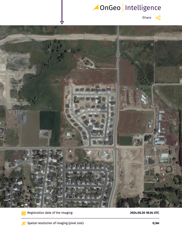
Sample Satellite Imagery Report from OnGeo Intelligence
Conclusion: obtain the satellite insights you require, without the hassle.
The realm of satellite imagery providers presents vast opportunities. While direct engagement with various satellite data sources, both commercial and public, is an option, it often involves considerable complexity.
OnGeo Intelligence refines this process, making it straightforward to check image availability from numerous suppliers and acquire what you need – be it a quick-look PDF summary or detailed high-resolution data complete with source files.