Download the Satellite Map of Rio de Janeiro – Free Printable PDF
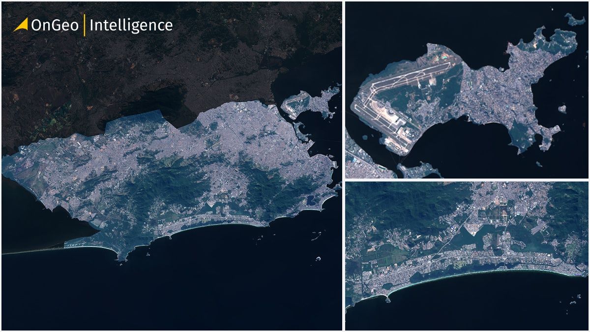
Rio de Janeiro, one of the world’s most iconic cities, is famous for its coastline, mountains, and vibrant urban life. Now you can see the entire city from above — thanks to a free downloadable satellite map prepared by OnGeo Intelligence. Using high-resolution Sentinel-2 imagery, this printable PDF map offers a clear, natural-color view of Rio’s complex geography.
Download a High-Quality Satellite Map of Rio de Janeiro – PDF
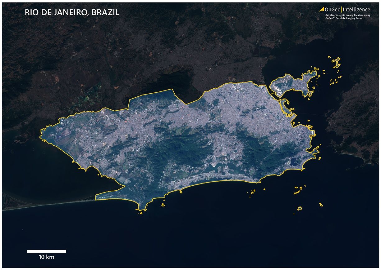
This printable map shows the full area of Rio de Janeiro with sharp detail and natural coloring. Designed using 2024 satellite data, it is available in A3 PDF format — perfect for personal, educational, or professional use.
📥[Download Satellite Map of Rio de Janeiro (PDF, 19.7 MB)]
Format: A3 PDF
File Size: 19.7 MB
Year: 2024
Features: Yellow city boundary, darkened background for contrast, scale bar, OnGeo Intelligence branding
Rio de Janeiro Satellite Map Thumbnail Low Quality
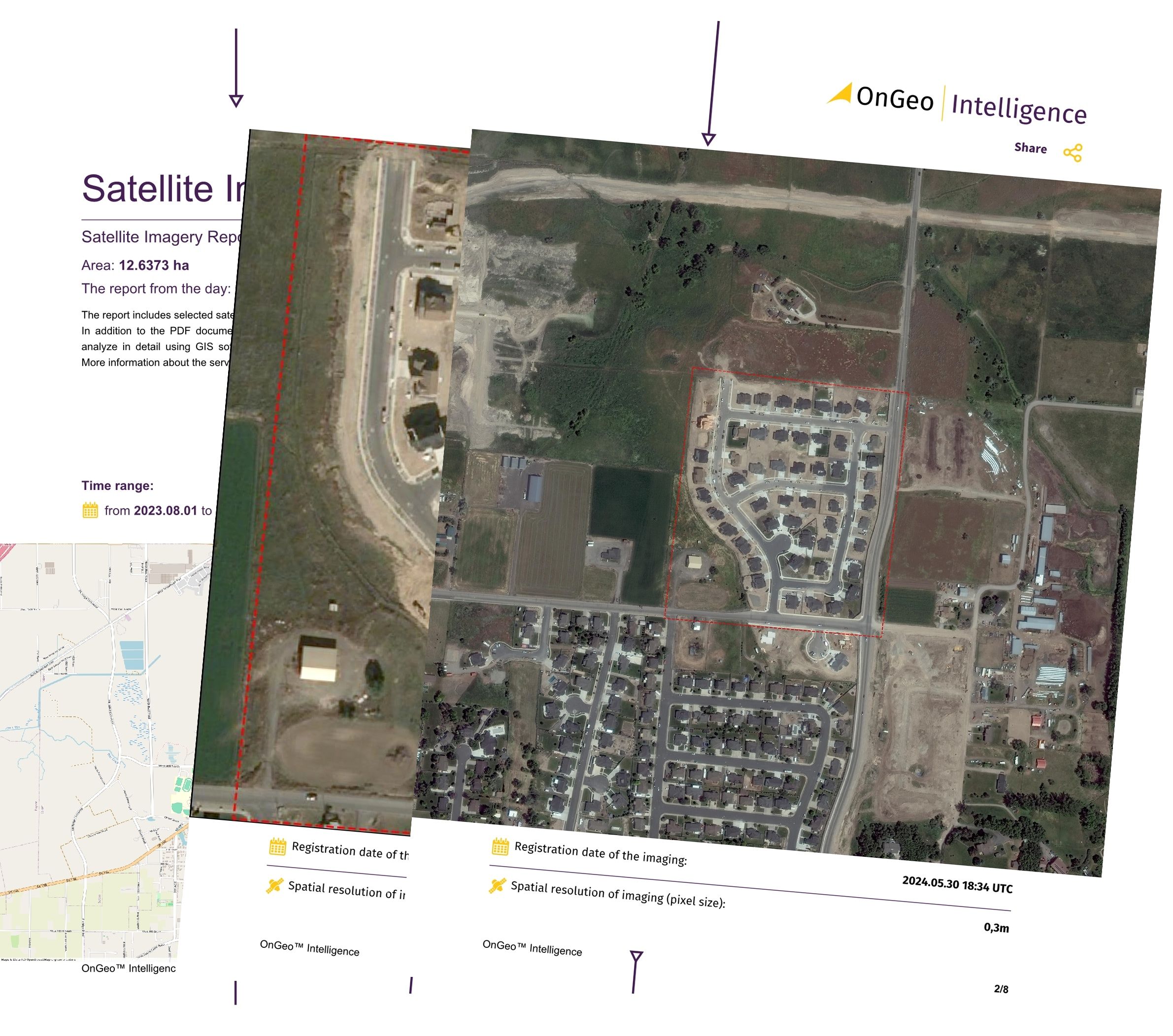
OnGeo Satellite Imagery Report – Instant Map of Your Property
Need satellite imagery of a specific property, parcel, or zone in Brazil or anywhere else?
With the OnGeo Satellite Imagery Report, you can generate a custom satellite map in seconds — no login required.
🛰 Highlights:
Very high-resolution satellite images
Fast, mobile-friendly PDF access
Order directly from your phone or desktop
Ideal for landowners, architects, investors, and planners
Explore OnGeo Intelligence:
What the Satellite Map of Rio de Janeiro Contains
This satellite map delivers a detailed visual of Rio’s natural and urban structure, including:
Urban zones, neighborhoods, and industrial areas
Famous coastlines including Copacabana and Ipanema
Sugarloaf Mountain, Corcovado, and Tijuca Forest areas
Bridges, highways, and major transportation corridors
Lagoa Rodrigo de Freitas and Guanabara Bay
Green areas and rocky hills surrounding the city
Yellow-marked city boundary
A darkened outer region for clarity and contrast
Title: Rio de Janeiro, Brazil
Scale bar in the bottom-left
Satellite Map of Rio de Janeiro – Tailored to Your Needs
Need this map with a different scale, format, or a focused area (e.g., only southern zone, favelas, or coastal districts)?
📧 Contact us at: contact@ongeo-intelligence.com
We provide custom satellite maps tailored to any specifications.
Who Created the Map and How It Was Made
This map was produced by the OnGeo Intelligence team — specialists in remote sensing, geospatial analytics, and digital cartography.
We used Sentinel-2 RGB imagery from 2024 and processed it using professional GIS tools to enhance clarity, color balance, and geographic accuracy. The final product is optimized for both on-screen display and printing.
Satellite cartography is widely used in:
Urban planning
Land use monitoring
Coastal zone management
Academic and environmental research
Public presentations and reports
How to Use the Map
You are welcome to use and print this map for:
🎓Personal, educational, or research purposes
📝Reports, presentations, and publications (please credit: “Source: OnGeo Intelligence”)
🏤Urban planning, real estate, or environmental projects
⚠️You may modify the map for your own use, but please retain attribution to OnGeo Intelligence.
Explore More City Maps Soon
Rio de Janeiro is part of our growing library of free downloadable city satellite maps. Upcoming locations include São Paulo, Brasília, Lima, Bogotá, and more.
📌 Visit OnGeo-Intelligence.com regularly for updates or follow us on social media.
Related articles
- Download the Satellite Map of Buenos Aires – Free Printable PDF
- Download the Satellite Map of São Paulo – Free Printable PDF
- How to Get a Current Satellite Map of My Property
- Download the Satellite Map of Mexico City – Free Printable PDF
- Download the Satellite Map of New York City – Free Printable PDF