How To Choose The Satellite Imagery For Your Needs?
Choosing the right satellite imagery can feel like navigating a complex landscape, especially with so many options available. This guide will help you understand the key factors to consider – from resolution and area coverage to spectral bands and even licensing – so you can confidently choose satellite imagery that perfectly fits your project's requirements.
Choose the Right Satellite Imagery: A Practical Guide for Your Project
Satellite imagery offers a powerful perspective on our world, but its effective use begins with selecting the right type of data. The process of defining an order for satellite-derived products, especially for institutional use, can be complex, involving technical, legal, and procedural aspects.
1. Define Your Goal: What Do You Want to Monitor or Achieve?
This is the foundational step. Before diving into technical specifications, clearly articulate what you aim to accomplish. Are you:
- Monitoring changes on a specific property over several years?
- Assessing the health of crops during a growing season?
- Tracking the progress of a large construction project?
- Identifying areas affected by a natural disaster like a flood or wildfire?
- Conducting environmental research on deforestation or water body changes?
Your objective will heavily influence all subsequent choices when you choose satellite imagery. For complex projects, this often involves collaboration between various specialists, as the required knowledge may exceed individual capabilities. The supplier and the end-user must work together to achieve the goal.
2. Determine Your Area of Interest (AOI) and Coverage Needs
How large an area do you need to cover? Is it a single small plot, a city, a county, or an entire region?
- Precision is Key: The area of interest must be defined very precisely, ideally using a GIS vector file (like a Shapefile or KML). This avoids ambiguity, especially in formal procurement.
Did You Know?
In the OnGeo Intelligence platform, the process of defining the area of interest has been simplified to the maximum. Users don't need to prepare complex vector files. Instead, they can easily use an intuitive drawing tool directly on the interactive map within our order form to precisely mark the selected area.
- Quantitative Requirements: Define the surface area to be covered and, if applicable, the frequency of data delivery for these units.
3. Consider Temporal Aspects: Dates and Update Frequency
- Date Range: Specify the period for which you need imagery. Do you need historical data, the most recent available image, or ongoing monitoring? Archives from some satellites go back decades.
- Phenological Period (If Relevant): For agricultural or forestry applications, you might need imagery from a specific phenological stage (e.g., leafless period for better ground visibility).
- Update Frequency (Revisit Time): How often do you need new images? For rapidly changing phenomena (e.g., disaster response, active construction), a high revisit rate is crucial. For long-term change detection, less frequent updates might suffice. Be clear about the delivery interval if regular updates are needed.
4. Spatial Resolution: How Much Detail Do You Need?
Spatial resolution refers to the size of a single pixel on the ground. This is one of the most critical factors influencing both usability and cost.
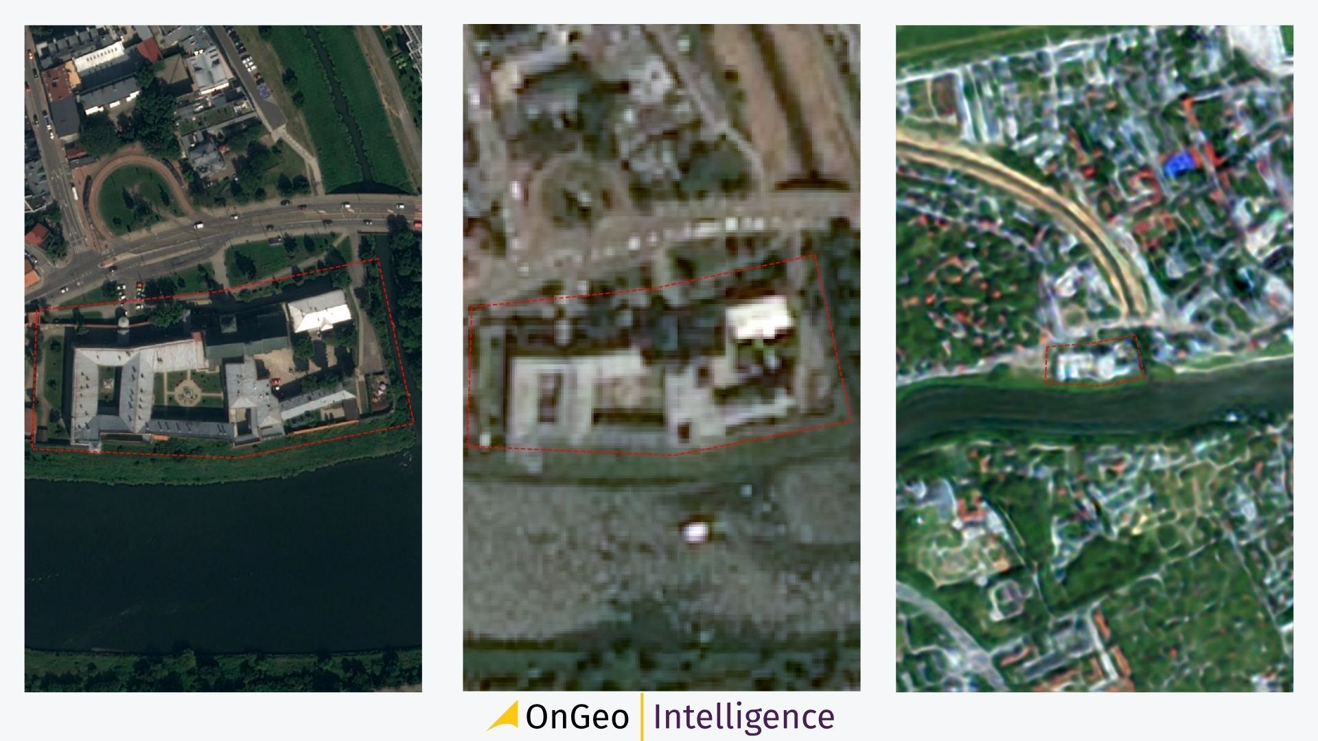
- Very High Resolution (VHR: e.g., 0.3m to 2m): Allows identification of small objects like individual cars, trees, building outlines, or fence lines. Essential for detailed urban analysis, construction monitoring, precise property boundary verification, and legal evidence.
- High Resolution (HR: e.g., 2m to 5m): Good for identifying groups of buildings, road networks, or distinct agricultural fields.
- Medium Resolution (MR: e.g., 10m to 30m): Suitable for large-area land cover mapping, regional vegetation health monitoring (like Sentinel-2 at 10m), or tracking large-scale environmental changes.
- Low Resolution (LR: >30m): Used for global weather patterns or oceanographic studies.
You can now choose satellite imagery and order low-resolution satellite imagery report for free, using the code "ongeo100".
Very high-resolution images (up to 0.3 m) are also available as a paid option.
5. Spectral Resolution: What "Colors" Do You Need to See?
Satellites can "see" beyond the visible light spectrum. Different materials reflect and absorb light differently across various wavelengths.
- Panchromatic (PAN): A single grayscale band, often offering the highest spatial resolution. Excellent for discerning shapes and structures.
- Multispectral (MS): Captures data in several spectral bands (e.g., red, green, blue, near-infrared - NIR, short-wave infrared - SWIR). Essential for:
- Vegetation Analysis: Creating indices like NDVI (Normalized Difference Vegetation Index) to assess plant health.
- Water Body Delineation: Identifying water presence.
- Soil Moisture Assessment: Using indices like NDMI (Normalized Difference Moisture Index).
- Land Cover Classification: Distinguishing between different surface types.
- Hyperspectral: Captures data in many, very narrow spectral bands, providing highly detailed spectral information. Used for very specialized research.
6. Other Technical Considerations (Often for Advanced Users/Procurement):
- Maximum Cloud Cover: Specify the acceptable percentage of cloud obstruction in the imagery.
- Maximum Sensor Off-Nadir Angle: The angle at which the satellite sensor views the target. Higher off-nadir angles can introduce distortions but increase collection opportunities.
- Minimum Sun Elevation Angle: Affects shadows and illumination. More critical in high-latitude regions or for specific terrain analyses.
7. Licensing and Usage Rights
This is a crucial, often overlooked aspect, especially in institutional or commercial settings.
- Operator Licenses: Satellite operators provide their data based on their own license agreements. These are generally non-negotiable.
- Permitted Use: The intended use of the data must fall within the scope of exploitation areas covered by the operator's license. Ensure your intended use (e.g., internal analysis, public display, derivative product creation) is permitted.
- Procurement: When acquiring data (e.g., via public tender), the requested usage rights cannot exceed those granted by the satellite operator's license.
Choosing satellite imagery involves understanding your project's goals and matching them with the appropriate data characteristics – from resolution and spectral bands to timing and licensing. While the technical details can be intricate, defining your needs clearly is the most important first step. For many users, platforms that simplify the selection, processing, and delivery of satellite data, like OnGeo Intelligence, can provide a much more accessible path to valuable Earth observation insights.