🌍 Capture the world at 100% OFF! Use code ongeo100on 10 meters satellite image resolutions – limited time only! Higher resolution satellite images remain subject to payment.
🌍 Capture the world at 100% OFF! Use code ongeo100on 10 meters satellite image resolutions – limited time only! Higher resolution satellite images remain subject to payment.
How Often Do satelites Take Pictures? Satellite Imagery Frequency
2025-03-04
(Article updated:
2025-03-04
)
~ 6 min
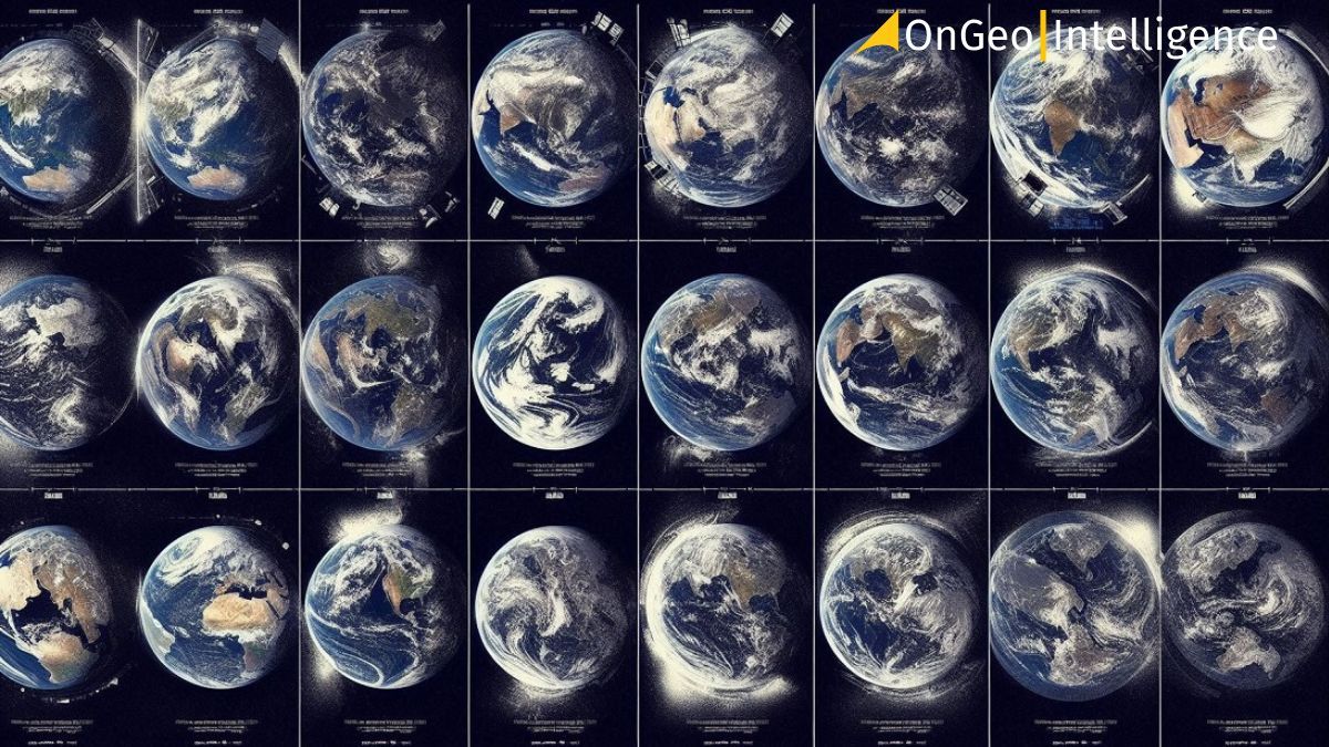
Satellites orbiting Earth capture fascinating images, but how often?
This leads us to the topic of satellite imagery frequency: Do they photograph Earth continuously, or on a schedule?
This article explores the nuances of image frequency, differences between public/commercial options, and major data providers.
High-Quality Satellite Imagery, Hassle-Free
Explore any location on Earth with precision. Order a detailed Satellite Imagery Report—no sign-ups, no contracts. Delivered in a clear PDF for instant insights.
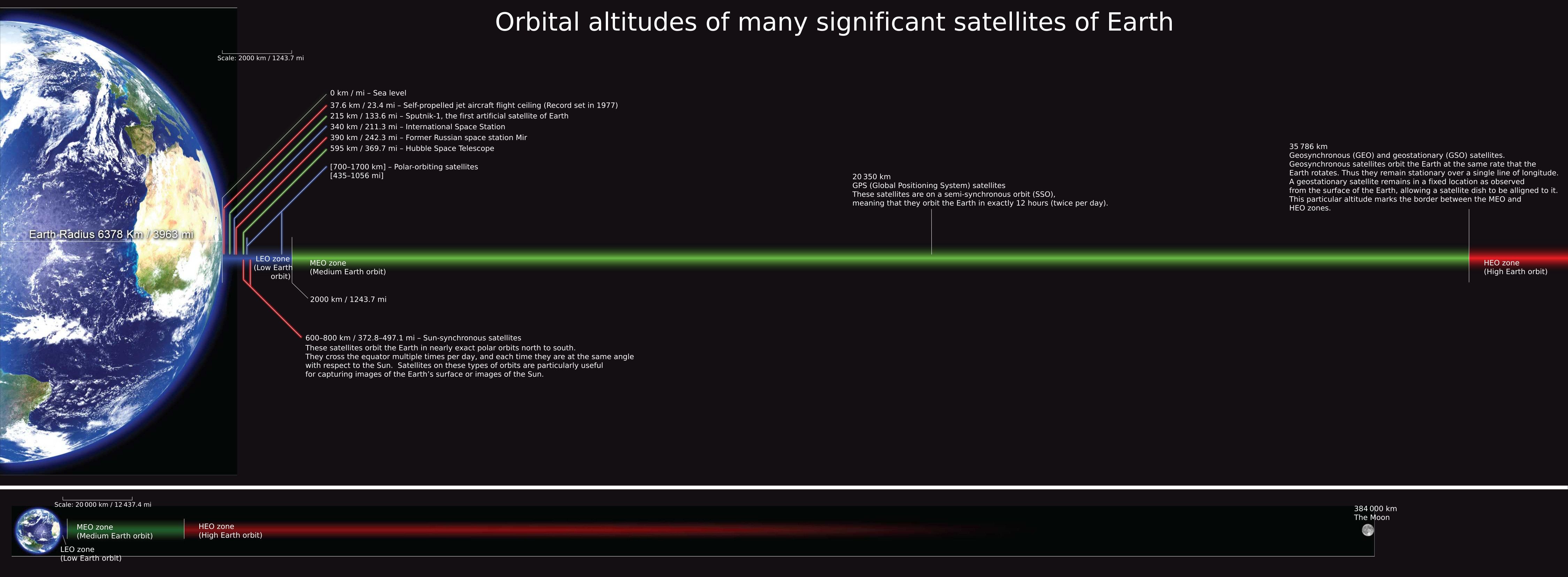
Satellite imagery frequency is determined by several factors, including the satellite's orbit, design, and mission objectives. Civilian Earth observation satellites typically operate in low Earth orbit (LEO) at altitudes ranging from 100 to 2,000 km, most often a few hundred kilometers.
The majority travel along polar orbits, usually heliocentric, enabling them to cover the entire planet’s surface. These satellites orbit Earth with a period of approximately 90-100 minutes, moving at speeds between 6.9 and 7.8 km/s.
Orbital altitudes of many significant satellites of Earth, by Mark Mercer - Own work
Landsat 8
According to the official Landsat program website, this satellite images the entire Earth every 16 days. In collaboration with Landsat 9, this revisit time shortens to 8 days for a given area.
Sentinel-2
The Copernicus mission, with two satellites (2A and 2B), offers a revisit time of 5 days, and for some applications, even 3 days when accounting for camera tilt angles (off-nadir).
SPOT 6 and 7
These Airbus satellites cover up to 6 million km² daily—more than the entire EU’s surface area—delivering images at a 1.5-meter resolution.
Planet Dove
Planet’s constellation of over 430 minisatellites photographs all of Earth’s land surface daily, with a resolution of 3-5 meters.
Meteosat-8
Geostationary satellites, positioned in GEO (36,000 km above the equator), capture images every 15 minutes, though these are primarily meteorological data, with an orbital speed of 3.08 km/s.
During a single orbit lasting 1-3 hours, Earth rotates, allowing the satellite to image different surface sections in narrow strips.
After a few or several days, the satellite revisits the same area—hence the concept of temporal resolution, or revisit time.
Atmospheric conditions and other challenges
The fact that a satellite takes a picture doesn’t guarantee it will be usable. Optical satellites like Landsat or SPOT are sensitive to cloud cover, which can render images worthless. In contrast, radar satellites (SAR), such as TerraSAR-X or ICEYE (with 38+ satellites), can “see” through clouds, but their imaging frequency depends on mission goals or specific orders.
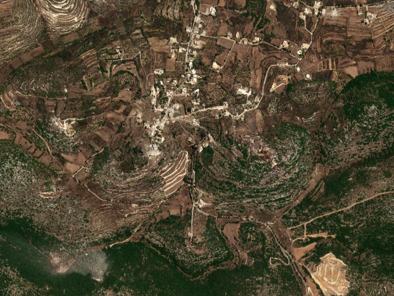
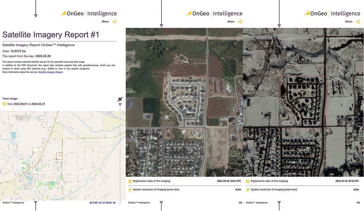
Cloudy versus cloud-free 0.3m resolution satellite imagery from a Satellite Imagery Report OnGeo™ Intelligence
Tiltable camera systems (off-nadir) enhance flexibility by reducing revisit times, though the angle can affect image quality.
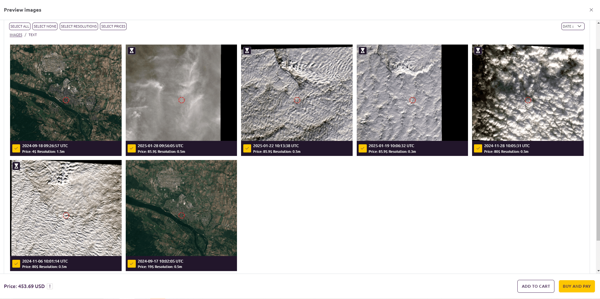
With Satellite Imagery Report OnGeo™ Intelligence, you can preview available satellite imagery before committing to a purchase, ensuring you only pay for cloud-free scenes. This enables you to reject images with clouds, optimizing your investment.
Available Imagery Preview in OnGeo Intelligence: Visualize Satellite Imagery Frequency Before You Order
Commercial Satellites – Satellite Imagery Frequency
Public satellites like Landsat and Sentinel operate on transparent schedules, however, commercial satellites offer flexibility regarding satellite imagery frequency. Companies like Maxar, Airbus, and Planet offer images captured either on client request or at the operator's discretion.
Maxar: With 8 optical satellites (e.g., WorldView-3, 30 cm resolution), images are often taken “on demand,” with frequency dictated by client priorities.
Airbus Pléiades: The Pléiades 1A and 1B satellites (0.5 m resolution, 20 km scene width) offer daily revisits to any location on Earth, though their standard cycle is 26 days without specific tasking.
Planet: With over 430 active optical satellites, it scans Earth daily, but not every image is saved—a business decision.
Find out:
Commercial operators often build data archives for later sale, raising the question: are images saved if no one orders them? They likely capture them regularly, but the data is curated based on demand.
Who Has The Most Data? A Provider Overview
Analysis of provider websites and available sources reveals that not all disclose details about imaging frequency:
USGS EarthExplorer: Free Landsat data (every 8-16 days) and other public missions.
Copernicus Data Space: The ESA portal provides Sentinel data—7 satellites (5 optical, 2 radar), with Sentinel-1 offering broad applications.
Planet: With 430+ optical satellites and 6 petabytes of archives, it’s the leader in daily coverage.
Maxar MGP Pro: 8 satellites (WorldView, GeoEye-1), delivering high-resolution imagery, though more selective than daily.
Airbus OneAtlas: 6 satellites (4 optical: Pléiades, SPOT; 2 radar: TerraSAR-X, PAZ), offering daily revisits on demand.
ICEYE: 38+ radar satellites, perfect for weather-independent monitoring.
SpaceWill: 15 satellites (12 optical, 3 radar), lesser-known but growing.
Planet excels in volume and frequency, Maxar and Airbus lead in quality (VHR), while public sources like USGS provide free access.
We use cookies to run our website, analyze your use of our services, manage your online preferences & personalize ad content. By accepting our cookies, you'll get relevant content and social media features, personalized ads, and an enhanced browsing experience. To manage your choices, click "Cookie Settings." Necessary cookies are required for the core website functionality and cannot be rejected. For more information, see our Cookie Policy.
About cookies on this site
Cookies used on the site are categorized. Below you can allow or deny some or all of them, except for Necessary Cookies which are required to provide core website functionality. When categories that have been previously allowed are disabled, all cookies assigned to that category will be removed from your browser.
Some cookies are required to provide core functionality. The website won't function properly without these cookies and they are enabled by default and cannot be disabled.
Preference cookies enables the web site to remember information to customize how the web site looks or behaves for each user. This may include storing selected currency, region, language or color theme.
Analytical cookies help us improve our website by collecting and reporting information on its usage.
Marketing cookies are used to track visitors across websites to allow publishers to display relevant and engaging advertisements. By enabling marketing cookies, you grant permission for personalized advertising across various platforms.
The cookies in this category have not yet been categorized and the purpose may be unknown at this time.