🌍 Capture the world at 100% OFF! Use code ongeo100on 10 meters satellite image resolutions – limited time only! Higher resolution satellite images remain subject to payment.
🌍 Capture the world at 100% OFF! Use code ongeo100on 10 meters satellite image resolutions – limited time only! Higher resolution satellite images remain subject to payment.
Maxar Technologies: Cutting-edge satellite imagery and innovative geospatial solutions
2024-10-08
(Article updated:
2024-11-28
)
~ 4 min
For decades, Maxar Technologies (formerly DigitalGlobe) has been a leader in delivering cutting-edge geospatial intelligence, providing unparalleled satellite imagery services to government, defense, and commercial sectors. Maxar's high-resolution data is trusted by industries including energy, mobility, telecommunications, and many more. Their advanced Earth Observation (EO) satellite fleet offers high-precision imagery, supporting critical decision-making processes across the globe.
High-Quality Satellite Imagery, Hassle-Free
Explore any location on Earth with precision. Order a detailed Satellite Imagery Report—no sign-ups, no contracts. Delivered in a clear PDF for instant insights.
Maxar operates a fleetof high-performance satellites that deliver imagery essential for intelligence, mapping, and monitoring applications worldwide. Here are the key operational satellites:
Resolution: 31 cm panchromatic, 1.24 m multispectral, 3.7 m SWIR
GeoEye-1 (Launched 2008)
Capabilities: High-resolution imagery with superior positional accuracy
Resolution: 41 cm panchromatic, 1.65 m multispectral
Archived satellites and historical imagery
Maxar’s archive provides access to decades of historical imagery from retired satellites, including:
QuickBird (2001-2015): Offered panchromatic imagery at 60 cm resolution and multispectral at 2.4 m. Its extensive dataset is a valuable resource for historical analysis.
IKONOS (1999-2015): First commercial satellite offering high-resolution imagery, with 82 cm panchromatic and 3.2 m multispectral.
WorldView-4 (2016-2019): Similar to WorldView-3 but with a shorter operational lifespan, delivering 31 cm panchromatic and 1.24 m multispectral images.
WorldView Legion – The next generation
Maxar is developing its newWorldView Legionconstellation, which will significantly boost revisit times and enhance monitoring capabilities. Four out of six satellites have already been launched, enabling up to 15 daily revisits over highly populated areas. The satellites are expected to offer 31 cm panchromatic and 1.24 m multispectral resolution, making them ideal for high-frequency monitoring and analysis.
At OnGeo Intelligence, we offer fast and easy access to high-resolution satellite imagery reports, available globally. Whether for monitoring your property, supporting legal proceedings, or other applications, our service delivers precise satellite data quickly.
Key features include:
Global Reach: Request imagery from anywhere on Earth.
No Hassle: No account needed—simply select your area of interest.
High-Resolution Data: Get detailed imagery perfect for various uses.
PDF Format: Receive easy-to-read reports in minutes.
Experience quick, reliable satellite imagery reports today on OnGeo-Intelligence.com—no long-term commitments, just the data you need.
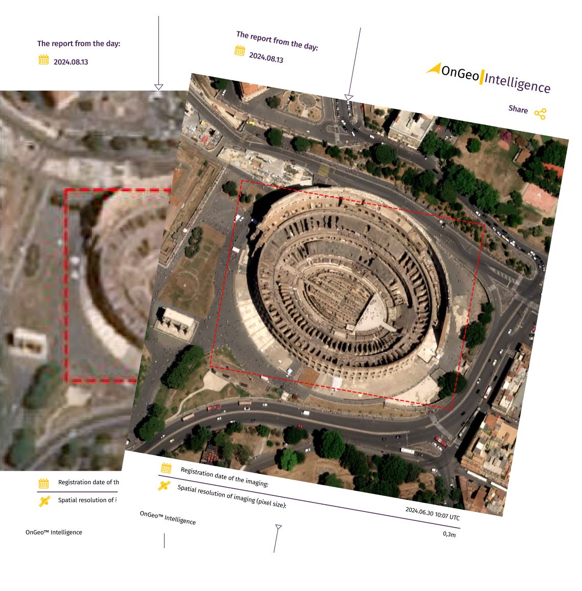
Maxar's optical imagery is distinguished by its exceptional resolution and multi-spectral capabilities, offering highly detailed and accurate Earth Observation data. The panchromatic imagery boasts a resolution of up to 30 cm, making it ideal for detailed mapping and precise monitoring applications.
The multispectral imagery, with resolutions ranging from 1.2 m to 1.85 m, enhances analysis across a variety of sectors, including agriculture, environmental monitoring, and urban planning. The multi-spectral bands typically cover 8 wavelengths across visible and near-infraredspectrums, allowing for diverse analysis of vegetation, water bodies, and urban features. In addition, Maxar provides short-wave infrared (SWIR)imagery, which adds another 8 spectral bands, enabling users to identify materials, detect minerals and uncover features that standard visible light cannot capture.
Maxar’s imagery allows for the identification and analysis of small objects and subtle changes over time. Products include analytic and stereo imagery, which enable 3D terrain analysis, change detection and feature extraction. Additionally, the imagery’s global coverage, high accuracy and consistency support a wide array of applications, from urban planning and disaster response to defense, agriculture and natural resource exploration. This makes Maxar's optical imagery a reliable and comprehensive tool for diverse geospatial needs.
Comprehensive services for diverse users
Maxar offers a range of advanced geospatial solutions that cater to different industries and needs:
Elevation Data: High-accuracy terrain models for geospatial analysis.
Mosaic & Basemap: Provides seamless, high-quality imagery mosaics and base maps for global coverage and easy integration.
Change Detection & Monitoring: Real-time insights for defense, urban planning, and natural resource management.
AI & Machine Learning: Automated feature extraction and object detection through advanced algorithms.
Vivid: A global basemap providing consistent, high-quality imagery for mapping and analysis.
SecureWatch: Cloud-based access to Maxar's satellite imagery and analytical tools for real-time monitoring and decision-making.
Crow’s Nest Maritime: Monitoring vessels and coastal areas with real-time change detection.
SecureWatch Analytics: On-demand analytics, such as change detection and object identification, enabling situational awareness and enhanced decision-making.
We use cookies to run our website, analyze your use of our services, manage your online preferences & personalize ad content. By accepting our cookies, you'll get relevant content and social media features, personalized ads, and an enhanced browsing experience. To manage your choices, click "Cookie Settings." Necessary cookies are required for the core website functionality and cannot be rejected. For more information, see our Cookie Policy.
About cookies on this site
Cookies used on the site are categorized. Below you can allow or deny some or all of them, except for Necessary Cookies which are required to provide core website functionality. When categories that have been previously allowed are disabled, all cookies assigned to that category will be removed from your browser.
Some cookies are required to provide core functionality. The website won't function properly without these cookies and they are enabled by default and cannot be disabled.
Preference cookies enables the web site to remember information to customize how the web site looks or behaves for each user. This may include storing selected currency, region, language or color theme.
Analytical cookies help us improve our website by collecting and reporting information on its usage.
Marketing cookies are used to track visitors across websites to allow publishers to display relevant and engaging advertisements. By enabling marketing cookies, you grant permission for personalized advertising across various platforms.
The cookies in this category have not yet been categorized and the purpose may be unknown at this time.