🌍 Capture the world at 100% OFF! Use code ongeo100on 10 meters satellite image resolutions – limited time only! Higher resolution satellite images remain subject to payment.
🌍 Capture the world at 100% OFF! Use code ongeo100on 10 meters satellite image resolutions – limited time only! Higher resolution satellite images remain subject to payment.
Satellite Imagery Report - generate it yourself
2024-04-15
(Article updated:
2024-11-29
)
~ 4 min
Do you need information about changes on your plot or do you want to monitor how the development of a selected area has changed over the past few months? Download the OnGeo™ Intelligence Satellite Imagery Report! By generating the report from the comfort of your own home, you can determine the property boundaries, locate newly built structures, or obtain the best documentation for legal and inheritance proceedings.
High-Quality Satellite Imagery, Hassle-Free
Explore any location on Earth with precision. Order a detailed Satellite Imagery Report—no sign-ups, no contracts. Delivered in a clear PDF for instant insights.
Thanks to OnGeo™ Intelligence, anyone with internet access can easily and quickly access advanced satellite technology. What was once reserved for industry professionals is now a source of basic terrain information for all of us.
What is the OnGeo™ Intelligence Satellite Imagery Report?
The OnGeo™ Intelligence Satellite Imagery Report is a document containing intelligently selected satellite scenes, showing your land or selected area in a chronological and organized manner.
You will receive reliable information that clearly shows any changes on your property, helping you better understand or prove what has happened during the period covered by the report. The satellite images will also indicate any problem areas, such as areas affected by drought, periodic wetlands, or erosion-prone areas, and this information could be crucial in taking action to mitigate the effects of these phenomena. Keep in mind that in the era of the need for documentation of events, satellite images are the most reliable source of information.
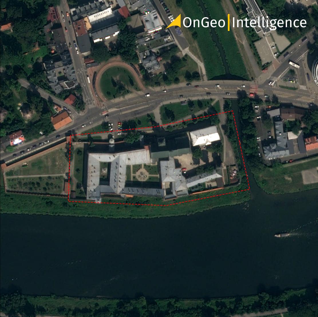
Pic. 1. Satellite imaging of the plot with a resolution of < 1.0 m
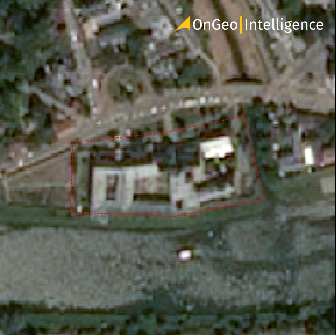
Pic. 2. Satellite imaging of the plot with a resolution of 1.0 m - 2.0 m
The data retrieval process takes only a few minutes, for low-resolution scenes and up to a maximum of 48 hours for high-resolution data. The data you ordered will appear in your email inbox as a user-friendly PDF document, chronologically organizing the satellite scenes and presenting changes in spectral characteristics of the area. The report includes a package of data with original and enhanced satellite data. Below you will find detailed instructions on how to generate the Satellite Imagery Report.
What is the Satellite Imagery Report useful for?
Satellite images taken at short intervals allow you to track the recent history of your land. You will not only learn how the land use has changed but also:
Estimate the construction time of buildings on the land or find out when they were damaged or renovated;
Check the phenomena occurring on the plot, such as crop growth or tree cutting, which is important in determining the production process on the plot;
Check the boundaries of the actual use of the property, which is particularly useful when monitoring the process of property violations;
Verify any damages on the selected area caused by biological or meteorological factors, such as natural disasters; Obtain evidence for the insurer in case of a legal dispute;
Track changes on your agricultural land, which will allow you to detect problems with crops, such as drought damage or crop diseases, early on;
Have a tool to determine the date of harvest based on a simple analysis of plant growth and changes in spectral characteristics of the cultivation area;
Monitor remotely what is happening on your property, even if you are on the other side of the world;
If you are a journalist, you can obtain press material documenting crisis events.
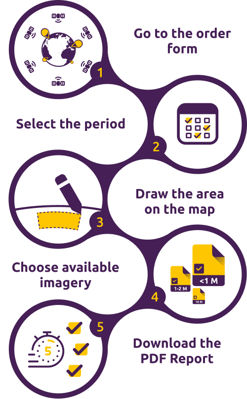
How to generate the Satellite Imagery Report?
Creating a Report with satellite images on OnGeo™ Intelligence is straightforward and involves just a few steps:
However, if you want to thoroughly analyze the changes that have occurred on the plot, you can also open the original satellite data and their enhanced version using artificial intelligence methods. These data have geolocation and can be imported into GIS software (e.g. the free QGIS package) to display the specific area of the Earth's surface they represent. You can analyze these data in conjunction with other geographic data, such as property boundaries. The GIS software allows you to adjust the view scale of the data to better examine the details visible in the satellite image.
We use cookies to run our website, analyze your use of our services, manage your online preferences & personalize ad content. By accepting our cookies, you'll get relevant content and social media features, personalized ads, and an enhanced browsing experience. To manage your choices, click "Cookie Settings." Necessary cookies are required for the core website functionality and cannot be rejected. For more information, see our Cookie Policy.
About cookies on this site
Cookies used on the site are categorized. Below you can allow or deny some or all of them, except for Necessary Cookies which are required to provide core website functionality. When categories that have been previously allowed are disabled, all cookies assigned to that category will be removed from your browser.
Some cookies are required to provide core functionality. The website won't function properly without these cookies and they are enabled by default and cannot be disabled.
Preference cookies enables the web site to remember information to customize how the web site looks or behaves for each user. This may include storing selected currency, region, language or color theme.
Analytical cookies help us improve our website by collecting and reporting information on its usage.
Marketing cookies are used to track visitors across websites to allow publishers to display relevant and engaging advertisements. By enabling marketing cookies, you grant permission for personalized advertising across various platforms.
The cookies in this category have not yet been categorized and the purpose may be unknown at this time.