Etna's Eruption Seen from Space: What Satellite Images Reveal
Etna's Eruption from Above
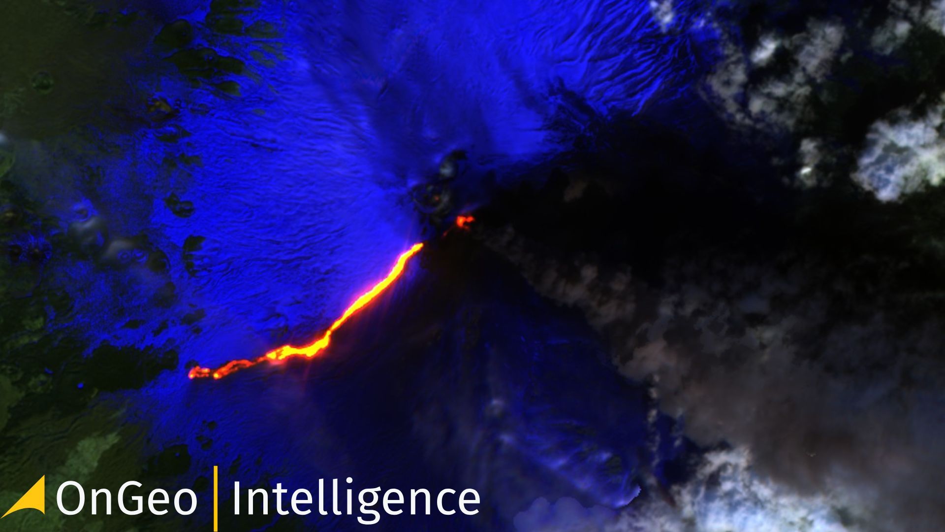
On the night of February 16-17, 2025, Mount Etna, Europe’s most active volcano, erupted once again, offering a spectacular yet concerning display of nature’s power. Satellite images captured this dramatic event, providing a unique perspective on the scale and impact of the eruption.
A Fiery Spectacle Seen from Space
Satellite monitoring has become an essential tool in tracking volcanic activity. The latest high-resolution satellite imagery clearly shows the lava flows, ash clouds, and thermal anomalies associated with the eruption. Thanks to real-time data, scientists and emergency services can analyze and predict the volcano’s behavior, helping to mitigate potential risks.
The Power of Satellite Technology in Disaster Monitoring
Satellite technology plays a crucial role in observing and understanding natural disasters. It allows for:
- Real-time tracking of eruptions – Continuous updates provide authorities with vital information.
- Monitoring ash dispersion – Aviation safety depends on precise data about ash cloud movement.
- Assessing environmental damage – Comparing satellite images before and after the eruption helps evaluate the destruction and long-term impact.
What Do the Latest Satellite Images Show?
The eruption of Etna was captured using advanced satellite imaging systems. The photos reveal:
- Massive lava flows moving down the slopes of the volcano.
- Dense ash clouds reaching high into the atmosphere, posing a risk to air travel.
- Thermal hotspots indicating intense volcanic activity beneath the surface.
How Can You Access and Analyze Satellite Images?
With modern technology, satellite imagery is more accessible than ever. Platforms specializing in geospatial intelligence offer tools for analyzing changes in landscapes, monitoring natural disasters, and assessing risks.
Whether you are a researcher, journalist, or simply curious about Earth’s dynamic processes, these images provide invaluable insights.
Etna’s latest eruption serves as a powerful reminder of nature’s force. Thanks to satellite technology, we can observe, analyze, and respond to such events more effectively than ever before.
If you want to explore satellite imagery and understand environmental changes, check out our services and stay informed about the latest developments.
Also read:
More information about the Satellite Imagery Report
Related articles
- High Resolution Satellite Imagery: Best Quality Sources
- Earth Observation: How Satellite Views of Your House Are Now at Your Fingertips
- Real-Time Satellite Imagery
- Satellite Imagery Archives: How to Access Historical Satellite Images
- Maxar Restores Ukraine’s Access to Satellite Imagery
- South Korea Wildfires: Satellite Images Reveal the Damage
- Landslide in Blatten, Switzerland: A Satellite Imagery Analysis