Legalisation of unauthorised buildings using satellite images
Unauthorized construction poses significant challenges for property owners. These structures, built without required permits, can lead to hefty fines, demolition orders, or legal disputes. However, legalizing such constructions is possible, and satellite imagery has emerged as a powerful tool to streamline this process. OnGeo Intelligence provides high-resolution satellite imagery that can serve as critical evidence in legalisation of unauthorised buildings using satellite images. In this article, we explore how OnGeo Intelligence’s satellite imagery can be leveraged for legalization, highlight real-world examples, and demonstrate why investing in these reports is a smart choice for property owners and investors.
The Challenge of Unauthorized Construction
Unauthorized buildings create multifaceted problems for governments, municipalities, and landowners:
Public Safety Risks: Structures built without permits often fail to meet safety standards, endangering residents and neighboring communities.
Urban Planning Disruption: Illegal constructions interfere with city layouts, complicating infrastructure development and resource allocation.
Economic Impacts: In countries with high property taxes, unauthorized buildings enable tax evasion, reducing municipal revenue.
Land Expropriation: Some builders illegally construct on private or public land, aiming to legalize their actions later, which undermines property rights.
Inefficient Monitoring: Traditional monitoring systems rely heavily on human oversight, which is time-consuming, costly, and prone to delays.
These challenges are particularly acute in countries with underdeveloped legislative and enforcement systems, where identifying illegal constructions early remains complex and resource-intensive.
The Solution: Satellite Imagery and AI-Powered Detection
OnGeo Intelligence revolutionizes the legalisation of unauthorised buildings using satellite images by providing easy access to high-resolution satellite imagery without the need for account registration. Users can quickly obtain satellite images through the platform’s intuitive interface by selecting a specific area of interest and instantly accessing up-to-date, high-quality imagery. This streamlined process eliminates barriers, enabling municipalities, landowners, and government agencies to monitor construction activities efficiently. OnGeo Intelligence automates the identification of illegal activities, significantly reducing the need for on-site inspections and easing the financial burden on municipalities. Early detection of unauthorized constructions also minimizes costs associated with demolition or retroactive legalization, ensuring timely compliance and safer urban environments.
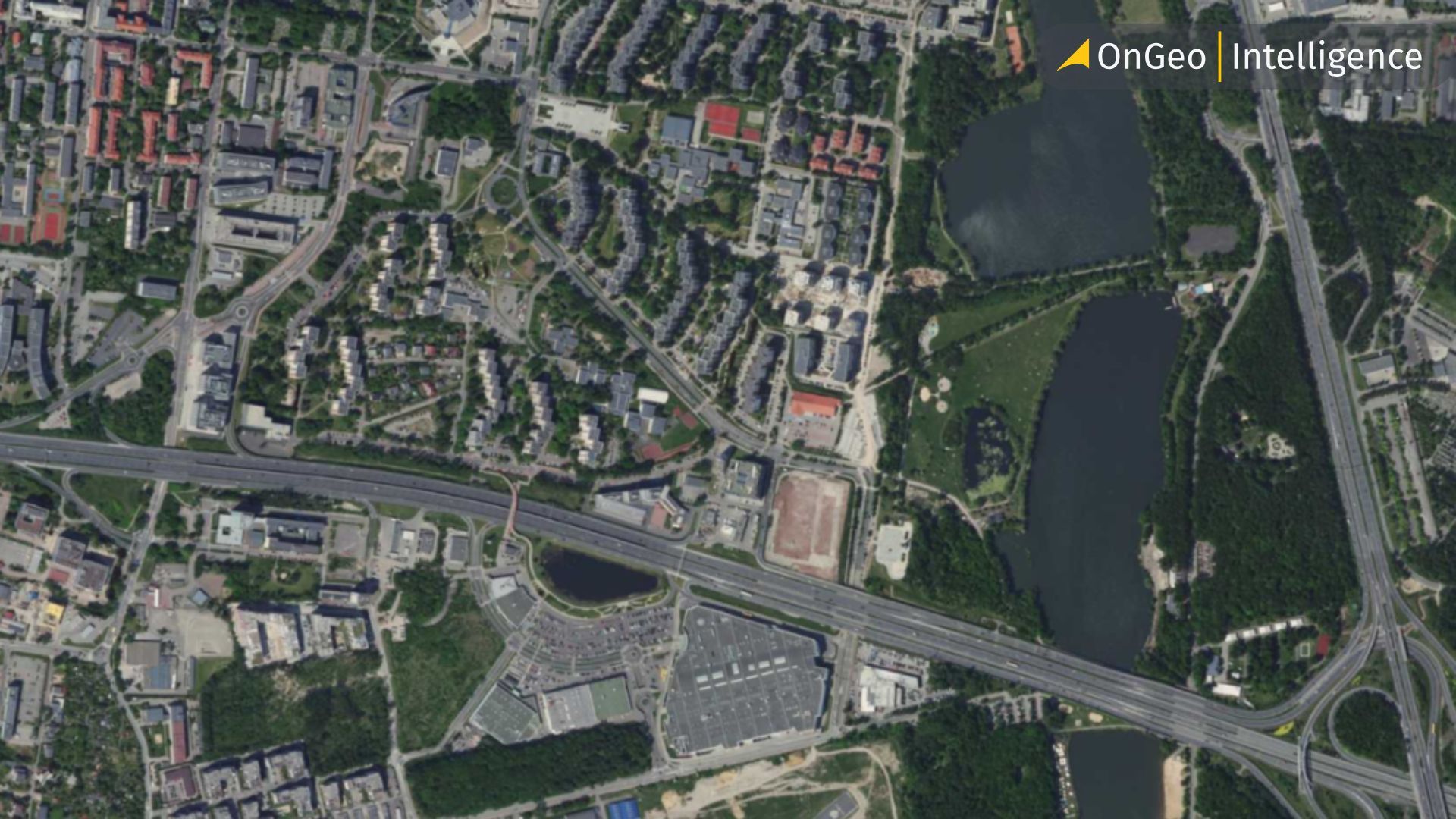
The Role of Satellite Imagery in Legalization
Satellite imagery provides a bird's-eye view of land developments over time. By analyzing chronological images, stakeholders can:
Identify Unauthorized Structures: Detect changes in land use or new constructions that lack official records.
Establish Construction Timelines: Determine when a structure was built, aiding in the legalization process.
Support Legal Documentation: Provide visual evidence for administrative or legal proceedings.
How Satellite Imagery Supports Legalization of unauthorised buildings: The Process
Legalisation of unauthorised buildings using satellite images involves several steps, and satellite imagery from OnGeo Intelligence can play a pivotal role at each stage:
Proving the Structure’s Age: OnGeo’s archival imagery can confirm the structure’s existence at a specific point in time, supporting claims about its age.
Verifying Compliance with Zoning Laws: Authorities require evidence that the structure aligns with local spatial planning regulations. OnGeo’s high-resolution images allow for detailed analysis of the building’s location, size, and surrounding land use, ensuring compliance with zoning requirements.
Documenting Changes Over Time: Satellite imagery can show how a property has evolved, helping to identify unauthorized modifications or expansions. This is particularly useful for complex cases involving partial samowola.
Supporting Technical Assessments: During legalization, an expert must assess the building’s safety and compliance with technical standards. Georeferenced Sentinel-2 imagery can complement geodetic surveys and technical reports, providing a comprehensive view of the site.
Evidence in Disputes: In legal or administrative disputes, such as those involving neighbors or insurance claims, OnGeo’s timestamped imagery serves as indisputable evidence of the structure’s history and condition.
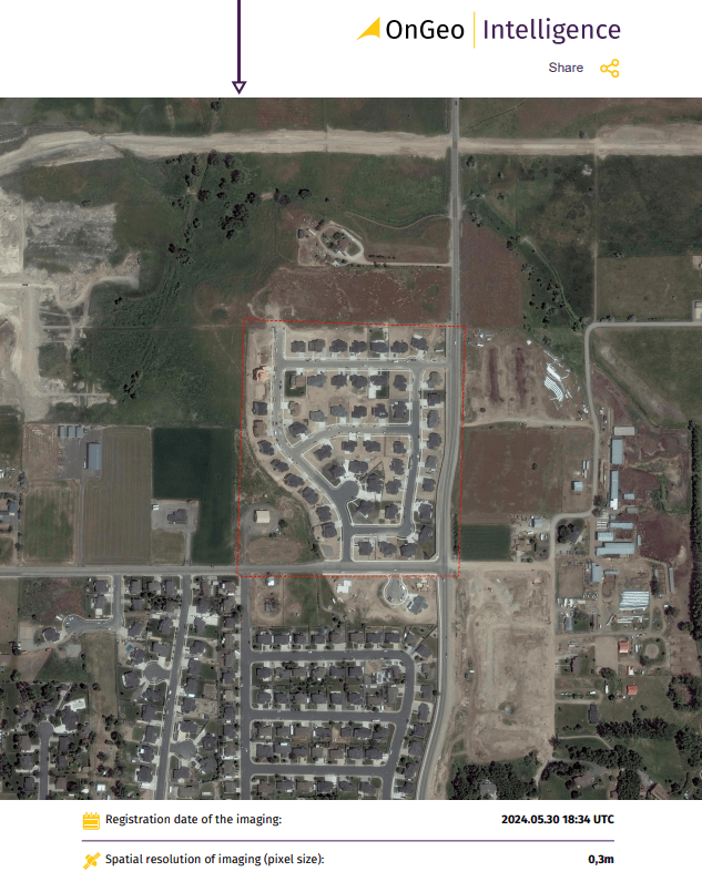
The process is simple: select a location and date range on OnGeo Intelligence platform, order the report, and receive a professional PDF document via email. This streamlined approach eliminates the need for time-consuming searches through public archives or costly on-site surveys.
Real-World Examples of Success with OnGeo Intelligence
Case Study 1: Rural Home Legalization
A homeowner sought to legalize a small house built in the 1990s without a permit. The simplified legalization process required proof that the house was over 20 years old. The owner ordered an OnGeo Intelligence Satellite Imagery Report, which provided clear images from 2001 showing the house in its current form. Combined with a technical expertise confirming the structure’s safety, the imagery convinced the local nadzór budowlany (building supervision authority) to approve the legalization without additional costs. The homeowner avoided a potential fine and secured the property’s legal status, increasing its market value.
Case Study 2: Commercial Warehouse
A business owner faced a tax audit that flagged an unregistered warehouse expansion from 2005. To avoid penalties and legalize the structure, the owner used OnGeo’s high-resolution imagery to document the expansion’s timeline. The report, showing the warehouse’s footprint in 2006, was submitted alongside a geodetic survey and zoning compliance certificate. The authorities accepted the evidence, and the legalization was completed under the standard procedure, saving the business from a costly demolition order.
Case Study 3: Dispute Resolution
A property developer was embroiled in a dispute with a neighbor claiming that a garage was built illegally on their land. The developer ordered an OnGeo report with imagery, proving the garage existed before the neighbor purchased the adjacent plot. The timestamped, georeferenced images resolved the dispute in court, saving the developer from litigation costs and preserving the property’s value.
These examples illustrate how OnGeo Intelligence’s satellite imagery can turn complex legalization cases into manageable processes, delivering tangible financial and legal benefits.
Why Choose OnGeo Intelligence for Legalization?
OnGeo Intelligence specializes in delivering high-resolution satellite imagery and comprehensive reports that are tailored for various applications, including legal and administrative processes. Here’s why their service stands out for legalisation of unauthorised buildings using satellite images:
High-Resolution Imagery: OnGeo provides images with resolutions as fine as 30 cm per pixel, allowing for detailed visualization of structures, boundaries, and land use changes. Images with 10-meter resolution can be enhanced to 2.5 meters using AI, improving clarity for legal documentation.
Rapid Delivery: Reports for low-resolution imagery are generated in as little as 5 minutes, while high-resolution data is available within 48 hours. This speed is crucial for meeting tight legal deadlines.
Georeferenced Data: The imagery comes with georeferencing, enabling precise spatial analysis in GIS software, which is often required by authorities to verify compliance with zoning plans.
User-Friendly Format: Reports are delivered as easy-to-read PDFs, complete with timestamps and natural-color (RGB) visuals, making them accessible for property owners, lawyers, and officials alike.
Historical Data Access: OnGeo’s archives allow users to retrieve imagery from specific dates, critical for proving a structure’s age in simplified legalization cases.
By investing in an OnGeo Intelligence Satellite Imagery Report, property owners can obtain professional documentation that strengthens their case, potentially saving thousands in fines or demolition costs.
Addressing Global Challenges
The issue of unauthorized construction is not confined to developing nations. Even in countries with robust regulations, tax evasion and illegal extensions are prevalent. OnGeo Intelligence’s platform is versatile, addressing:
High-Tax Regions: Identifying properties underreporting square footage to evade taxes.
Rapidly Urbanizing Areas: Monitoring sprawling cities where manual oversight is impractical.
Legally Complex Environments: Supporting enforcement in regions with weak regulatory frameworks.
Conclusion
The legalisation of unauthorised buildings using satellite images is a critical step toward safer, more sustainable cities. OnGeo Intelligence’s satellite imagery platform offers a powerful, automated solution to detect illegal constructions, ensure tax compliance, and protect land rights. By combining high-resolution imagery, AI-driven analysis, and real-time notifications, this technology empowers municipalities and landowners to address the challenges of urbanization head-on. As cities continue to grow, tools like OnGeo Intelligence will be essential for fostering compliance, safety, and harmony in urban environments.