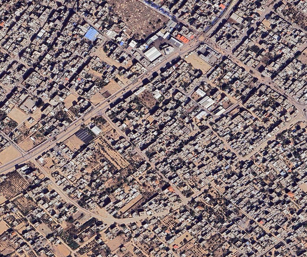
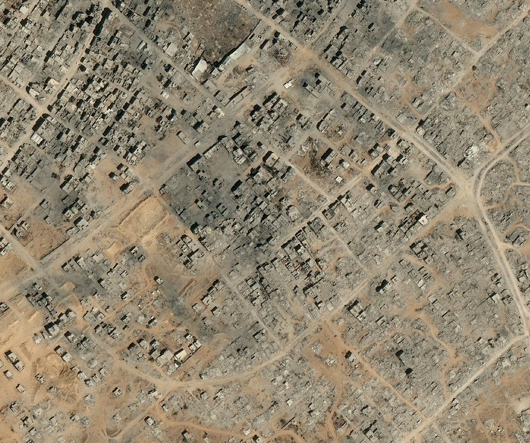
Satellite Images Reveal Devastating Before-After Views of Gaza City
High-resolution satellite data documents the systematic demolition of Gaza City's urban infrastructure across multiple districts. Analysis of orbital imagery confirms at least 50 multistory buildings have been destroyed during recent military operations, while broader assessment indicates more than 1,800 structures sustained damage or complete destruction within weeks.
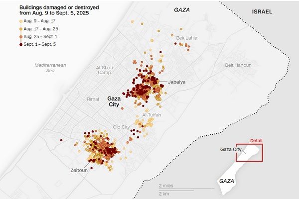
Neighborhood-level satellite analysis reveals concentrated destruction patterns. Zeitoun district experienced particularly severe damage, with over 1,500 residential and commercial buildings reduced to debris fields since early August. Adjacent Sabra district recorded similar devastation—more than 1,000 structures demolished following the August 6 military escalation. These orbital monitoring systems capture both infrastructure loss and demographic displacement, tracking a population that numbered nearly one million residents during summer months.
Current evacuation data shows approximately 400,000 Palestinians relocated under military directives, yet satellite-verified population density suggests 500,000 people remain within northern Gaza territories. The imagery provides quantifiable metrics for understanding both physical destruction and civilian displacement across affected urban zones.
Israel flattens Gaza City neighborhoods with military force
Military operations across Gaza City have targeted high-rise infrastructure, with approximately 50 buildings demolished within a 48-hour period. Defense Minister Israel Katz characterized the campaign as striking with an "iron fist" against designated terrorist infrastructure. Combined air and ground operations have systematically cleared entire residential blocks through coordinated strikes and mechanical demolition.
Prime Minister Netanyahu described current operations as "only the introduction" to expanded ground campaigns. Military reports indicate 20 tower blocks were demolished across Gaza City during the preceding two-week period. The destruction pattern extends beyond targeted strikes, with residential zones bearing the primary impact of large-scale clearance operations.
Dense urban districts have sustained concentrated damage across multiple neighborhoods:
- Zeitoun district recorded complete destruction of over 1,500 residential structures
- Tuffah, Shejaia, and Sheikh al-Radwan areas experienced systematic clearance operations
- Southern city sectors show extensive damage patterns detectable through aerial monitoring
Ground forces have deployed both precision airstrikes and heavy machinery—including excavators and bulldozers—for systematic block-level demolitions. While military officials cite infrastructure targeting objectives, civilian facilities have sustained significant impact. UNRWA documented strikes on 10 agency buildings within four days, including seven schools and two medical clinics that housed thousands of displaced civilians.
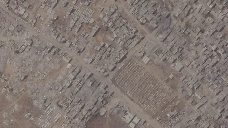
Satellite images before (left) and after (right) the destruction following Israeli insurgency in the Gaza Strip. Location: Khan Yunis, Gaza.
Satellite images reveal before-and-after devastation in key districts
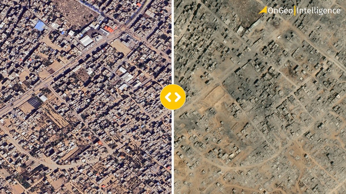
Temporal analysis using satellite imagery demonstrates complete urban transformation between July 17 and August 25, 2023, with entire Gaza City neighborhoods converted to barren terrain. While Zeitoun district's destruction was previously documented, comparative imagery now shows the methodical demolition process—16 excavators positioned at Israel's Zeitoun military base by August 25 indicate systematic clearing operations.
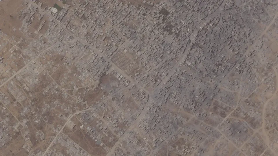
Gaza City's Zeitoun neighborhood is seen on August 9 (left), with its buildings largely intact, and on September 5, (right) when they are largely wiped out. Planet Labs PBC/cnn.com
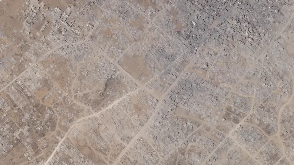
The destruction pattern extends across multiple districts. Tuffah and Shujaiyya neighborhoods, which maintained intact urban density through mid-July, appear completely leveled in subsequent satellite passes. Al-Saftawi neighborhood demonstrates similar devastation, with multi-story residential complexes and commercial buildings documented as demolished structures.
Jabalia refugee camp presents the most dramatic transformation. This settlement, which housed over 110,000 registered residents, has become virtually unrecognizable through orbital monitoring. Palestinian municipal data indicates approximately 50,000 housing units were bulldozed across this northern Gaza sector. Residents returning to these areas report finding "only rubble where his home had stood," while others describe walking "in the streets as if we are seeing them for the first time".
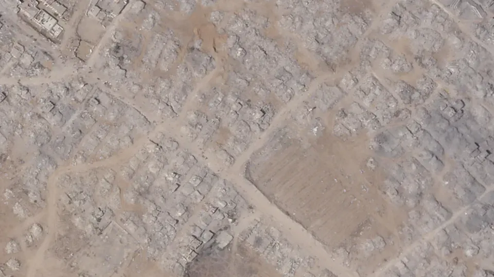
Tent camps can be seen southeast of Gaza City on August 9 (left). In an image taken September 5 (right) they are no longer visible. Planet Labs PBC/cnn.com
Comprehensive imagery analysis conducted by CUNY Graduate Center and Oregon State University researchers estimates nearly 60% of Gaza's total building stock sustained damage. Gaza City recorded the highest concentration of structural destruction across all monitored areas.
Mass displacement worsens humanitarian crisis in Gaza Strip
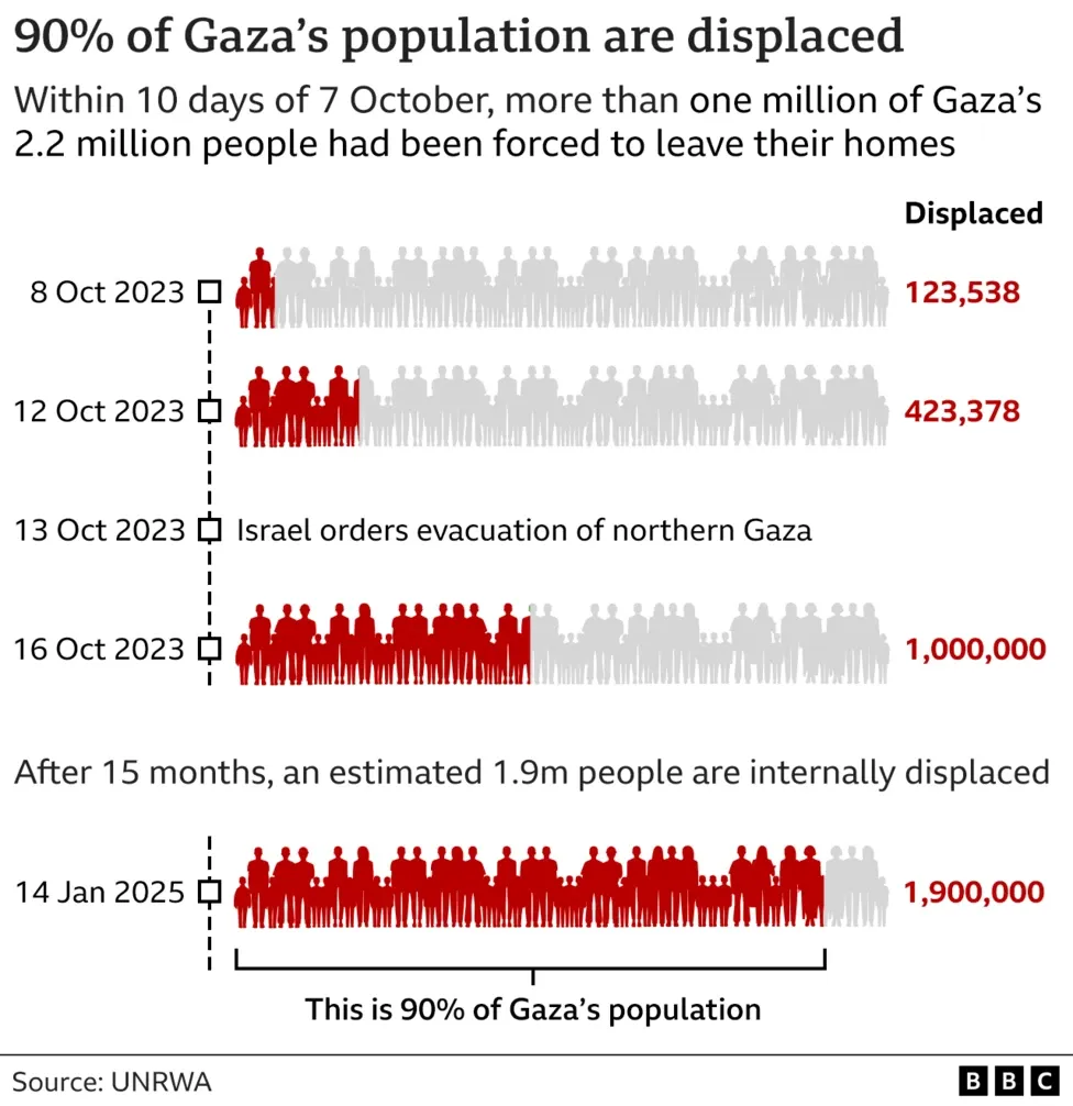
Population displacement metrics indicate 90% of Gaza's 2.1 million residents have been forced from their homes, with multiple relocations documented for individual families. Satellite monitoring throughout September 2025 tracked the rapid emptying of temporary settlements across Gaza City as evacuation directives expanded. Sheik Radwan neighborhood demonstrated this pattern—tent encampments visible in early September imagery had vanished entirely by month's end.
Displacement frequency data reveals severe mobility stress on affected populations. Since March, tracking systems recorded over 762,500 individual displacement events, averaging nine relocations per family unit. Healthcare personnel face particular challenges, as one medical worker explained: "I don't want to leave my patients, the little children whose bodies are too frail to deal with yet another displacement".
Territory designated as safe zones has contracted to 12% of Gaza's total area. Israeli evacuation protocols direct displaced populations toward southern humanitarian corridors, yet aid organizations report these zones lack essential infrastructure—adequate shelter, food distribution networks, water systems, or medical facilities. Demographic analysis shows children represent nearly half of all displaced individuals, with orphan population estimates reaching 17,000.
Medical system capacity has reached critical failure points. Hospitals report treating over 20,000 children for acute malnutrition as resource shortages intensify. The psychological impact compounds physical hardships, captured in one resident's assessment: "We are dead and still breathing".
Conclusion
Satellite monitoring technology provides quantifiable documentation of urban infrastructure destruction across Gaza City. These orbital datasets establish baseline measurements for damage assessment, tracking structural loss from functioning neighborhoods to cleared zones. The imagery serves dual analytical purposes: immediate damage quantification and long-term urban planning data for potential reconstruction efforts.
Gaza City's transformation from a high-density urban center to demolished districts demonstrates satellite surveillance capabilities in conflict documentation. The orbital record preserves spatial data that ground-based reporting cannot capture—comprehensive area coverage, temporal comparisons, and precise geographic coordinates for each affected zone. This technical documentation becomes essential for humanitarian organizations planning resource allocation and aid distribution strategies.
The satellite analysis reveals systematic patterns of destruction that extend beyond isolated incidents. Block-by-block demolition sequences, equipment deployment tracking, and population displacement monitoring provide objective metrics for understanding conflict impact on civilian infrastructure. These datasets support evidence-based decision-making for international humanitarian response and urban recovery planning.
Remote sensing technology continues monitoring ongoing changes, providing real-time updates on population movements, infrastructure status, and accessibility conditions. The accumulated satellite archive creates a permanent record of urban transformation, supporting both immediate humanitarian needs and future reconstruction requirements. This technical capability ensures documentation remains available regardless of ground access limitations or reporting constraints.
Related articles
- Satellite imagery of Gaza reveals the massive scale of destruction
- Lebanon Bombing: Satellite Images Reveals Scale of Destruction
- Using Satellite Imagery As Evidence In Judicial Proceedings
- Fighting modern slavery from space: How satellite data is shaping a new era of human rights protection
- War in Sudan: How Satellite Imagery Reveals Hidden Atrocities
- Satellite Imagery Reveals M23’s Environmental Destruction in Eastern DRC