Satellite Imagery Reveals M23’s Environmental Destruction in Eastern DRC
In recent months, newly released satellite imagery from eastern DRC has been revealing a troubling pattern. Large stretches of forest in North Kivu are disappearing at a speed that is hard to ignore. Much of this degradation is happening in areas controlled or heavily influenced by the M23 militia, where ground access is extremely limited and independent reporting is nearly impossible.
While the broader conflict has been widely covered, its environmental impact receives far less attention. Yet satellite images clearly show deforestation, charcoal production, makeshift roads and expanding extraction zones deep inside militia-held territory.
What’s happening in the forests of eastern DRC isn’t just a side effect of war - it’s part of how armed groups survive and finance their operations. Thanks to modern satellite technology, the scale and pace of this destruction can finally be tracked, measured and documented with a level of detail that wasn’t possible before.
This article outlines what satellite imagery reveals, why these findings matter, and how remote sensing has become an essential tool for understanding the hidden environmental dimensions of the war in DRC.
Historical Context: Who M23 Is and Why the Kivus Matter
M23 (March 23 Movement) emerged in 2012 in North Kivu, eastern Democratic Republic of Congo. Formed largely by soldiers who defected from the national army, the group seized key towns and strategic territory before being pushed back in 2013. After years of relative inactivity, M23 returned in 2021 with far greater strength, launching a new offensive that has displaced hundreds of thousands of civilians and reshaped control across the region.
The Kivu provinces - North and South Kivu - are some of Africa’s most resource-rich and environmentally sensitive regions. They host dense tropical forests, volcanic terrain, endangered wildlife habitats, fertile farmland and valuable mineral deposits. Control over land here has always been linked to political power and economic survival.
Much of this territory is remote, heavily forested or unsafe due to ongoing fighting. Independent observers rarely gain access, making satellite imagery one of the only reliable ways to understand what is happening on the ground - from troop movements to village destruction and environmental losses.
As M23 has expanded its influence, satellite data shows growing evidence of deforestation, charcoal production and land-use change in and around areas under its control. Historical imagery makes it possible to compare landscapes before and after the militia’s resurgence, revealing patterns that would otherwise remain hidden.
Key Factors Driving the Conflict in Eastern DRC
Competition Over Natural Resources
Kivu’s mineral wealth (gold, coltan, cassiterite), fertile land and dense forests make it a target for armed groups. These resources become sources of revenue - through mining, charcoal production, taxation or control of trade routes. This constant competition fuels both violence and environmental destruction.
Ethnic and Political Tensions
Longstanding disputes over land, identity and political representation repeatedly trigger conflict. These tensions provide fertile ground for militias to recruit members and expand their influence.
Weak State Presence
Large parts of eastern DRC suffer from minimal government presence. Armed groups often impose their own systems of taxation, resource management and security. As a result, deforestation and resource exploitation occur with virtually no oversight.
What Satellite Imagery Reveals in M23-Controlled Areas
Despite the challenges of on-the-ground reporting, satellite imagery offers an independent and objective view of what is happening in territories influenced by M23. Over the past two years, analysts and humanitarian groups have relied on high-resolution imagery from Sentinel-2, Airbus and Vantor to monitor environmental change across the Kivus.
The results are consistent - and increasingly alarming.
Rapid Decline of Forest Cover
Time-series analysis shows accelerated deforestation in areas recently taken over by M23. Common indicators include:
expanding clearings along ridges and forest edges,
new footpaths and vehicle tracks through protected areas,
a patchwork pattern typical of charcoal production sites.
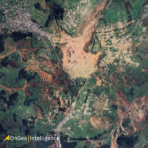
In Masisi, Rutshuru and Nyiragongo, forest loss often appears within weeks of territorial shifts, suggesting organized extraction rather than small-scale local use.
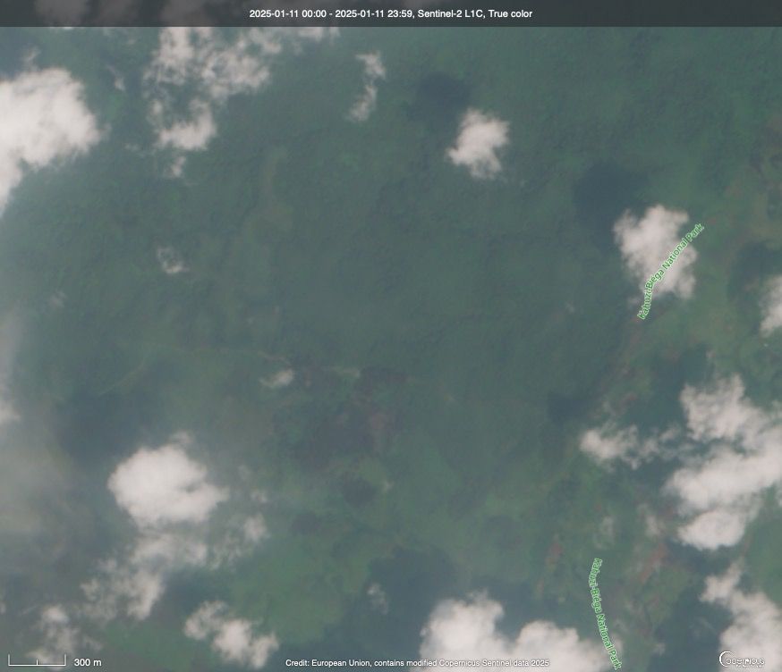
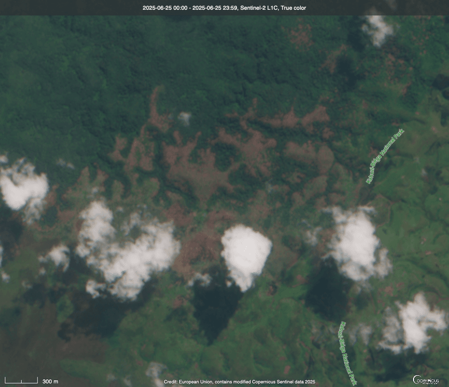
Photo Credits: Before Forest in Kahuzi-Biega National Park near Kasopo village, Kabare territory, on Jan. 11, 2025. After Satellite image of forest loss on June 25, 2025. Image credit: European Union, contains modified Copernicus Sentinel data 2025. Source: mongabay.com
Charcoal Production Hotspots
Satellite images reveal clusters of dark circular burn pits - signatures of charcoal kilns - multiplying in protected forests such as Virunga National Park.
Imagery helps map:
new kiln locations,
transport routes,
expanding illicit trade corridors.
These patterns align with long-standing reports that charcoal taxation is a key revenue stream for M23.
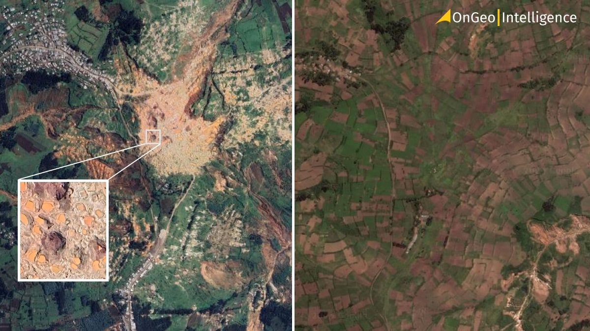
Mine de Rubaya before and afrer satellite image. In 2009, Rubaya appears to be largely pastoral, with only minor mining sites. But by 2021, illegal mining activity has expanded drastically. Source: google earth.
New Military Positions and Makeshift Camps
High-resolution images show newly constructed camps on hilltops, often carved into previously forested slopes. Visible features include:
defensive trenches,
tents and semi-permanent shelters,
widened roads for vehicle access.
These camps frequently appear next to freshly cleared forest, where trees are removed for firewood, defensive lines or improved visibility.
Abandoned Villages and Displacement Trails
Satellite imagery also highlights the human impact of the conflict:
entire villages emptied,
burned or destroyed houses,
broad vegetation scars marking displacement routes carved by thousands fleeing on foot.
These signatures match areas of recent fighting or militia advances.
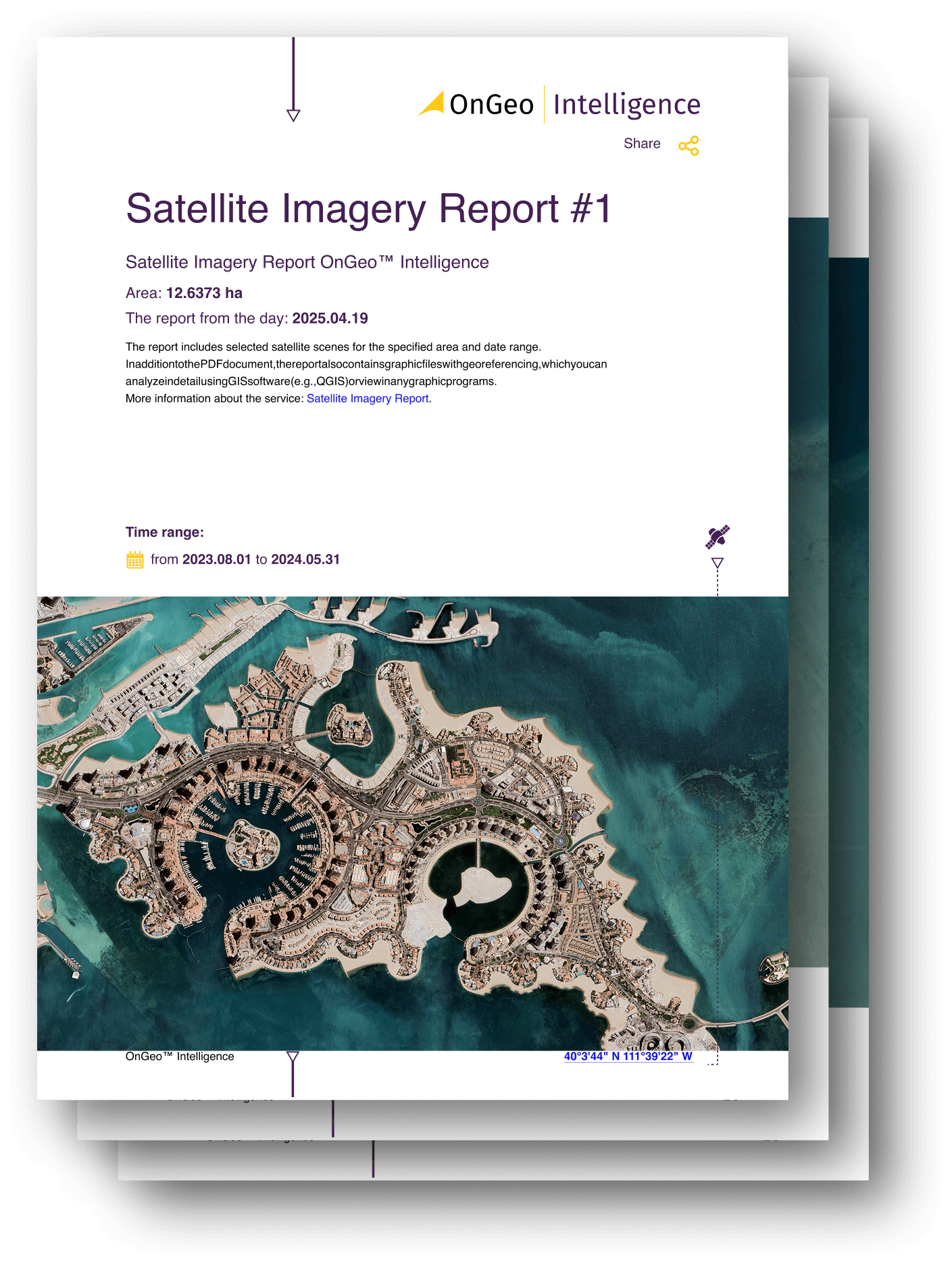
Get a Free Satellite Imagery from OnGeo Intelligence
Satellite imagery on OnGeo Intelligence is a service that provides high-resolution satellite images and reports for any location on Earth, without requiring a subscription.
Using the Satellite Imagery Report service is simple and accessible for everyone:
- Select location and time period
Pinpoint the area you want to analyze on an interactive map and specify the date range. - Search archives
The platform automatically locates satellite images available for your selected area and period. - Add images to your cart
Browse through the results and add your preferred scenes to your cart – all from your smartphone or desktop device. - Enter code ongeo100 at checkout
Apply the code during checkout to unlock free access to your report with 10 m resolution images enhanced using AI technology to 2.5 m per pixel.
High-resolution satellite images remain a paid service. - Receive your report via email
Low-resolution reports are delivered within minutes, while high-resolution reports are available within 48 hours.
How Analysts Verify and Interpret These Findings
Interpreting conflict-related environmental changes requires more than comparing before-and-after images. Analysts combine technical methods with contextual data to ensure reliability.
Time-Series Analysis
By examining imagery captured over weeks, months or years, analysts distinguish between:
natural seasonal changes,
conflict-driven disturbances.
Tools such as OnGeo Intelligence, Google Earth Engine, SentinelHub EO Browser and NASA help pinpoint when deforestation or burning started.
Spectral Indices
Using multispectral data from Sentinel-2 and Landsat, analysts apply indices such as:
NDVI - vegetation stress,
NBR - burned areas,
NDMI - vegetation moisture.
Sharp declines in these indicators often point to deforestation, charcoal activity or land degradation linked to armed groups.
Cross-Checking With High-Resolution Imagery
Once hotspots are identified using medium-resolution data, analysts verify them with commercial imagery from Maxar or Airbus. This confirms whether observed changes match:
charcoal kilns,
trenches,
abandoned structures,
vehicle routes.
Geographic Correlation With Conflict Reports
To avoid misinterpretation, satellite observations are cross-referenced with:
local news,
UN reports,
humanitarian assessments,
eyewitness testimonies,
verified videos.
When multiple independent sources align, confidence in the findings increases.
How OnGeo Intelligence Fits Into This Work
Satellite-based investigations - whether focused on conflict, environmental degradation or humanitarian risks - depend on accessible data, clear visual tools and efficient workflows. This is where OnGeo naturally fits into the process. We provides imagery from numerous missions, allowing analysts to quickly view: Sentinel-2 and high-resolution commercial imagery when detailed verification is needed.
OnGeo hosts processed maps, annotated imagery and analysis layers - a dependable archive for: journalists, humanitarian organizations, researchers documenting environmental crimes. This ensures deforestation events, burned villages or forced displacement routes remain accessible and verifiable.
Final Thoughts
The forests of eastern DRC are more than dense vegetation - they support communities, shelter wildlife and serve as vital carbon sinks. The ongoing M23 conflict is both a humanitarian crisis and an environmental emergency, as militia activity accelerates deforestation, illegal logging and habitat destruction.
Satellite imagery brings visibility to issues that would otherwise stay hidden. High-resolution images and time-series maps reveal the true scale of environmental damage in near real-time, helping organizations respond more effectively and advocate for accountability.
Related articles
- War in Sudan: How Satellite Imagery Reveals Hidden Atrocities
- Lebanon Bombing: Satellite Images Reveals Scale of Destruction
- Israeli Strikes on Natanz: A Satellite Imagery Analysis
- Amazon Deforestation: What Satellite Reports Reveal
- The Atlantic Forest Deforestation: South America's Silent Drama Seen from Space
- Biebrza National Park Fire: Destruction & Recovery Efforts
- How to Acquire Free Satellite Imagery for Your Investigations
- Satellite Forest Monitoring from Space: Global Tree Mapping with Satellite Earth Observation