🌍 Capture the world at 100% OFF! Use code ongeo100on 10 meters satellite image resolutions – limited time only! Higher resolution satellite images remain subject to payment.
🌍 Capture the world at 100% OFF! Use code ongeo100on 10 meters satellite image resolutions – limited time only! Higher resolution satellite images remain subject to payment.
Investment Planning from a Bird's Eye View: Land Analysis Using Satellite Imagery
2025-02-07
(Article updated:
2025-02-07
)
~ 5 min
Investment planning is a process that requires a comprehensive approach and in-depth land analysis. Traditional methods, such as site visits or geotechnical surveys, are time-consuming and costly. In the era of modern technology, satellite images are playing an increasingly significant role, allowing for a fast, accurate, and broad perspective of a given area. Thanks to them, investors can avoid potential risks, optimize costs, and plan their projects more effectively.
High-Quality Satellite Imagery, Hassle-Free
Explore any location on Earth with precision. Order a detailed Satellite Imagery Report—no sign-ups, no contracts. Delivered in a clear PDF for instant insights.
Satellite images are pictures of the Earth's surface captured by satellites equipped with advanced sensors. There are three main types of images:
Optical images – capture the visible light spectrum, offering a realistic representation of the terrain. They are commonly used in urban planning, agriculture, and environmental monitoring.
Multispectral data – covers infrared and other wavelengths, enabling the analysis of vegetation health, soil quality, moisture levels, and environmental pollution.
Radar images (SAR – Synthetic Aperture Radar) – allow terrain analysis regardless of weather conditions and time of day. They are useful for monitoring ground deformations, detecting landslides, and assessing infrastructure stability.
Modern satellites provide high-resolution images (up to 30 cm per pixel), ensuring precise detail representation and enabling accurate land analyses.
Benefits of Using Satellite Images in Investments
Accuracy and Time Savings - Thanks to advanced satellite imaging technologies, it is possible to quickly and precisely determine land conditions without the need for costly site visits. Investors can swiftly obtain key information about soil structure, existing infrastructure, and environmental changes.
Risk Reduction in Investments - Satellite image analysis allows for early detection of potential risks such as land waterlogging, landslide threats, or the absence of essential infrastructure. This helps avoid poor decisions and unforeseen expenses
Optimizing Investment Location - Detailed analysis of sunlight exposure, infrastructure accessibility, and terrain shape allows investors to select the best location for their projects, which can contribute to increased profitability.
Practical Applications of Satellite Images in Investments
Analysis of Land Accessibility and Infrastructure - Satellite images make it easy to assess a plot's location relative to roads, power grids, water supply networks, and rail lines. This information is crucial for developers planning residential areas, logistics centers, or industrial facilities.
Assessment of Geological and Hydrological Risks - Elevation models generated from satellite images help identify geological hazards such as landslides or flood-prone areas. This is especially important when planning investments in mountainous or lowland regions where groundwater level changes may occur.
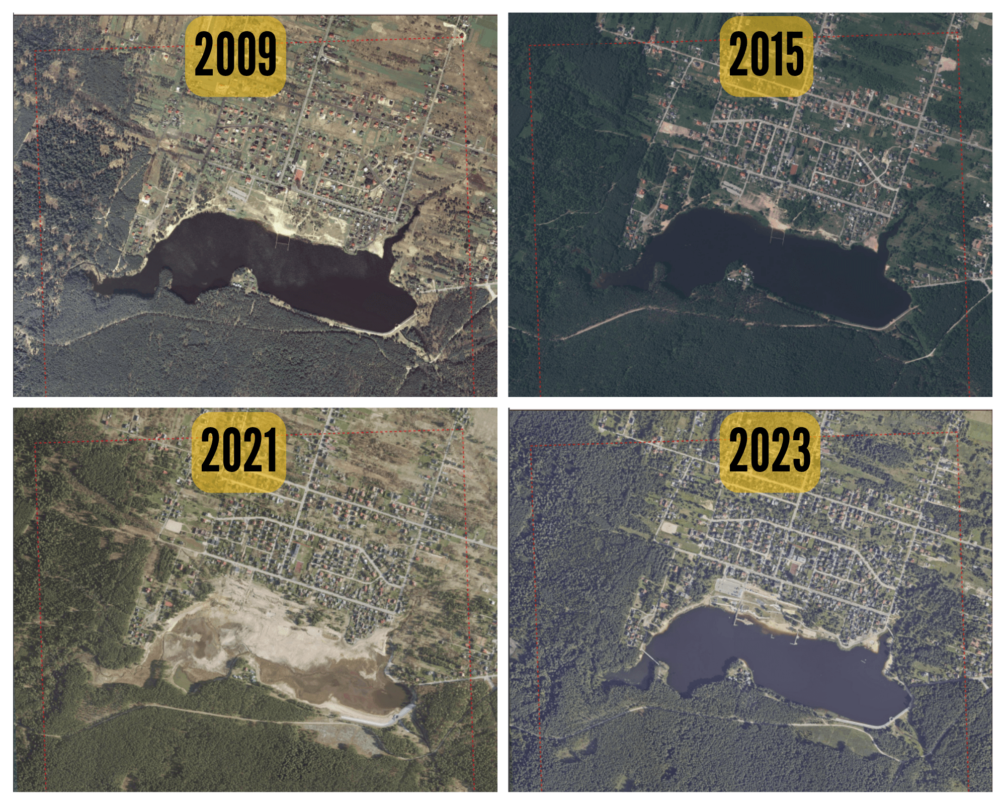
Tracking Land Use Changes - Analyzing historical images helps determine how a particular area has changed over time, allowing for the prediction of future land development and avoiding problematic areas.
Changes in the Lubianka Reservoir in Starachowice over the years (2009–2023) captured in satellite images. This type of data analysis allows for monitoring the impact of environmental and investment changes on the area.
Identifying Environmental Hazards - Multispectral images help detect soil contamination, groundwater level changes, and other factors that may impact investment profitability.
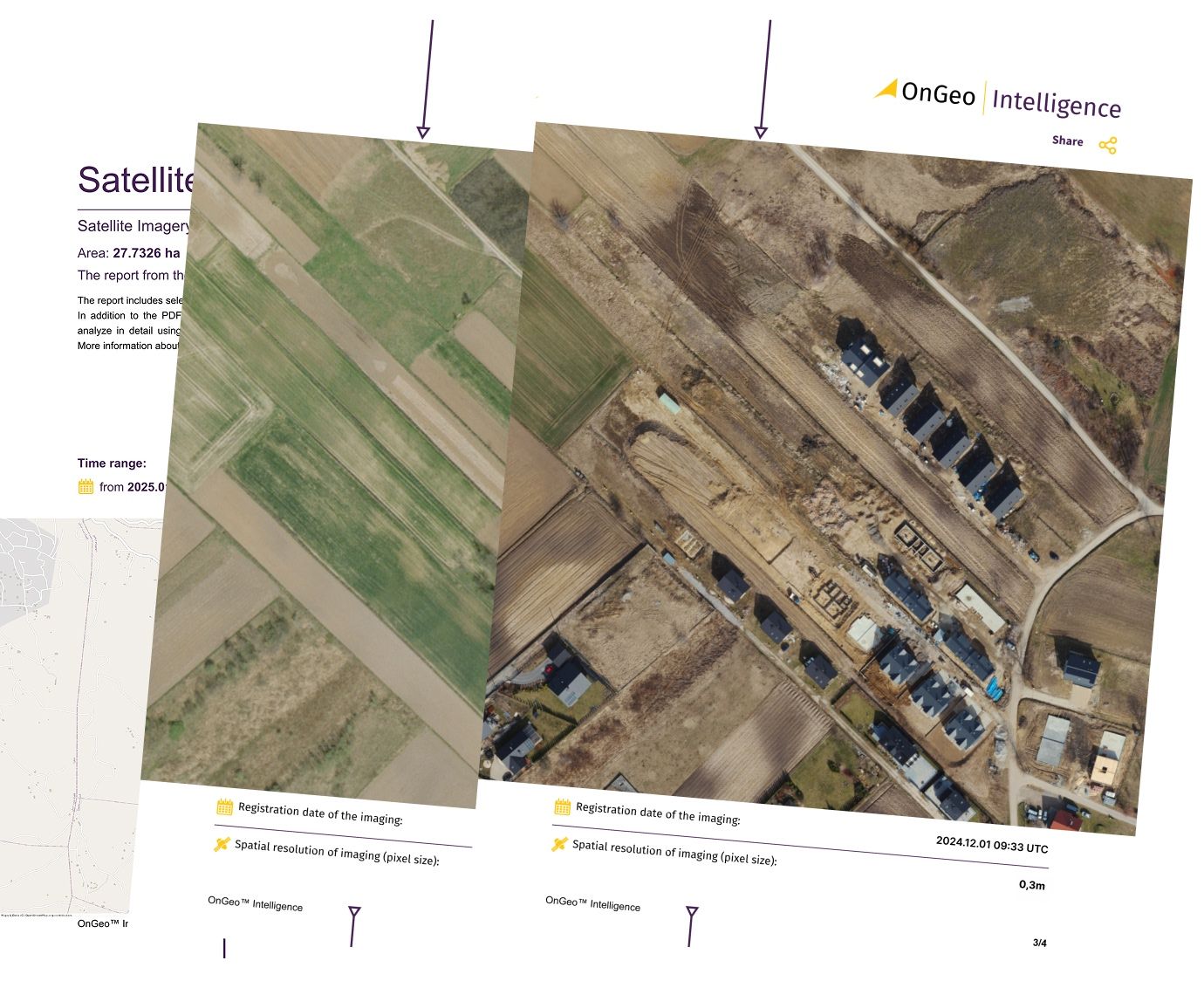
Monitoring Construction Progress - Satellite images allow for real-time assessment of investment progress. They enable tracking construction site changes, ensuring deadlines are met, and quickly identifying potential delays or issues.
Modern Technologies Supporting Satellite Analysis
Artificial Intelligence and Machine Learning - Modern algorithms enable automatic interpretation of satellite images, speeding up large-scale data analysis and increasing result accuracy. AI is particularly useful for monitoring infrastructure changes and predicting natural hazards.
Real-Time Data Access - Thanks to modern satellites, image updates can occur several times a day, allowing for real-time monitoring of dynamically changing areas.
Integration with GIS and Big Data - Combining satellite data with Geographic Information Systems (GIS) allows for even more precise analyses and the creation of advanced predictive models.
Commercialization of Satellite Technology - Companies like SpaceX and Planet Labs significantly reduce the cost of accessing satellite images, making this technology available not only to governments and large corporations but also to medium and small investors.
OnGeo Intelligence – A Comprehensive Investment Analysis Tool
With the OnGeo Intelligence platform, investors can leverage modern satellite analysis technologies to make informed business decisions. Our solutions provide:
• Fast and precise investment site assessment • Risk minimization by identifying geological and environmental threats • Utilization of historical data to predict spatial changes • Integration with other GIS tools and Big Data analyses
Want to learn more? Visit our website and see how OnGeo Intelligence can support your investments!
Satellite technologies are revolutionizing the way investments are planned. Precise land analysis, quick data access, and advanced artificial intelligence algorithms allow for risk minimization and cost optimization. OnGeo Intelligence is a solution that combines modern technologies with a practical investment approach, giving users a competitive advantage in the dynamically evolving world of real estate and infrastructure.
We use cookies to run our website, analyze your use of our services, manage your online preferences & personalize ad content. By accepting our cookies, you'll get relevant content and social media features, personalized ads, and an enhanced browsing experience. To manage your choices, click "Cookie Settings." Necessary cookies are required for the core website functionality and cannot be rejected. For more information, see our Cookie Policy.
About cookies on this site
Cookies used on the site are categorized. Below you can allow or deny some or all of them, except for Necessary Cookies which are required to provide core website functionality. When categories that have been previously allowed are disabled, all cookies assigned to that category will be removed from your browser.
Some cookies are required to provide core functionality. The website won't function properly without these cookies and they are enabled by default and cannot be disabled.
Preference cookies enables the web site to remember information to customize how the web site looks or behaves for each user. This may include storing selected currency, region, language or color theme.
Analytical cookies help us improve our website by collecting and reporting information on its usage.
Marketing cookies are used to track visitors across websites to allow publishers to display relevant and engaging advertisements. By enabling marketing cookies, you grant permission for personalized advertising across various platforms.
The cookies in this category have not yet been categorized and the purpose may be unknown at this time.