🌍 Capture the world at 100% OFF! Use code ongeo100on 10 meters satellite image resolutions – limited time only! Higher resolution satellite images remain subject to payment.
🌍 Capture the world at 100% OFF! Use code ongeo100on 10 meters satellite image resolutions – limited time only! Higher resolution satellite images remain subject to payment.
Tracking Urban Changes with Satellite Imagery: How Change Detection Reveals City Transformations
2025-02-14
(Article updated:
2025-02-14
)
~ 6 min
Cities all over the world are constantly changing - new buildings are being built, roads are being modernized, and green areas are unfortunately very often disappearing from previously established boundaries. In Poland, urban development is particularly dynamic, and tracking these changes plays a key role for urban planners, developers, but also residents. Thanks to modern satellite technology, we can monitor the transformation of urban space in virtually real time.
High-Quality Satellite Imagery, Hassle-Free
Explore any location on Earth with precision. Order a detailed Satellite Imagery Report—no sign-ups, no contracts. Delivered in a clear PDF for instant insights.
Change detection - what is it and how does it work?
Change detection is a technology that allows the comparison of satellite images taken at different times to detect changes in land use. By analyzing satellite images, it is possible to, among other things:
Track the development of new housing developments and road infrastructure.
Analyze changes in green spaces and recreational areas.
Monitor the effects of natural disasters such as floods and droughts.
Evaluate environmental pollution and the impact of urbanization on the urban climate.
Modern remote sensing systems use advanced image analysis algorithms that automatically detect changes based on high-resolution satellite images. Such solutions are becoming an essential component for cities planning for sustainable development and for companies involved in spatial analysis for new developments, urban planning, or monitoring changes in development.
Satellite observation of the Earth's surface makes it possible to study and analyze urban changes in many different ways. Satellites are enabling effective “tracking” such as infrastructure development, but also ecological and demographic changes.
Satellite images of cities have various applications, including:
Monitoring development: By comparing satellite images from different years, it is possible to determine the rate of development in cities and suburban areas. This allows you to assess where more money is needed to operate public transportation or improve access to public services, such as schools or government offices.
Analysis of urban greenery: Satellite images help track changes in parks and green spaces. It can be determined whether the city is nurturing the development of recreational space or, on the contrary, green areas are being degraded in favor of space for new development.
Evaluation of construction projects: The construction of new housing estates, office buildings or industrial facilities can be monitored based on satellite images. City managers and investors can check the compliance of project developments with zoning plans.
Tracking climate change: Satellites make it possible to assess the impact of infrastructure use on the urban climate, for example by analyzing so-called urban heat islands, areas with higher temperatures compared to rural areas.
Flood risk management: Analysis of historical satellite imagery makes it possible to assess how water levels in rivers and reservoirs are changing and which areas are most vulnerable to flooding.
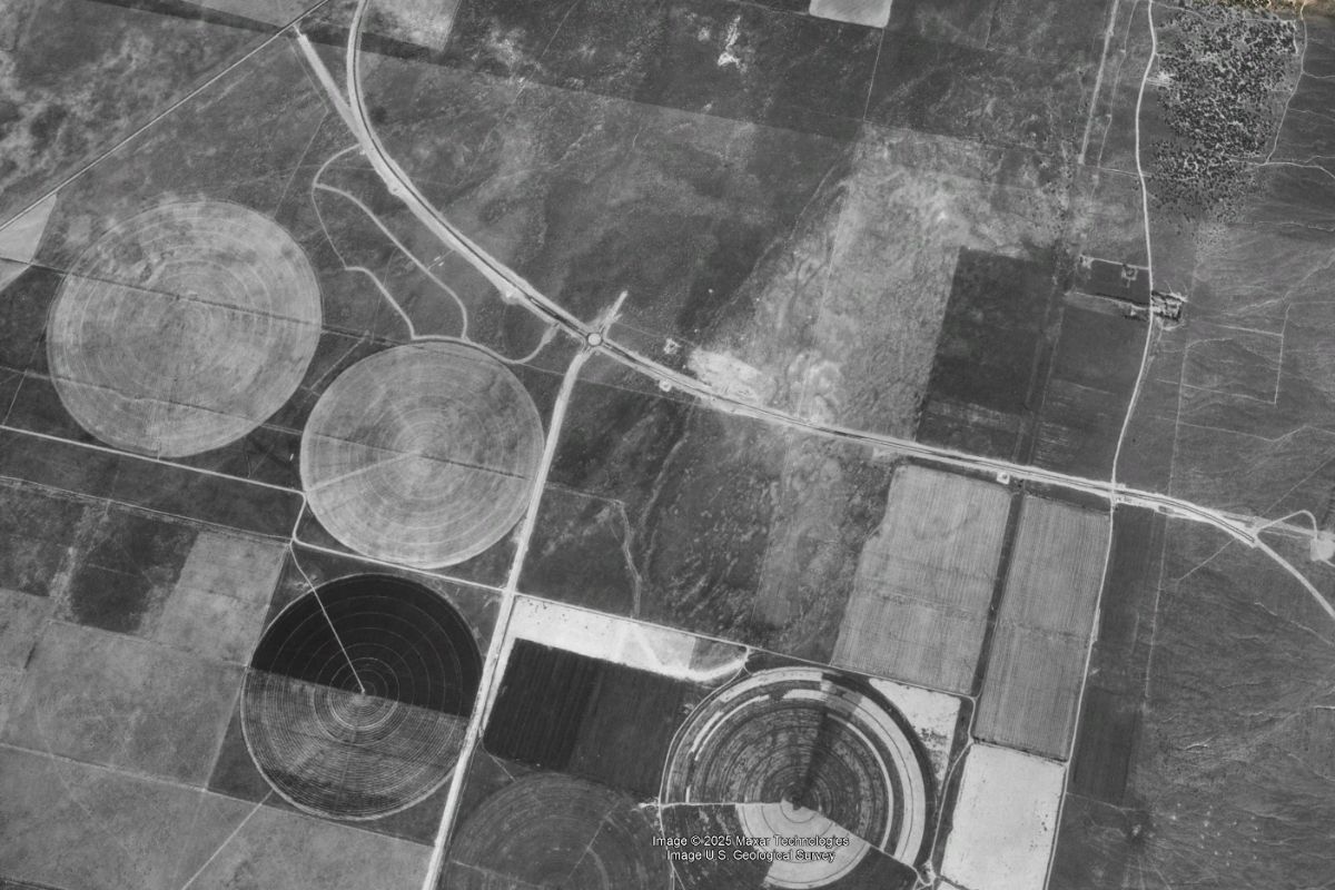
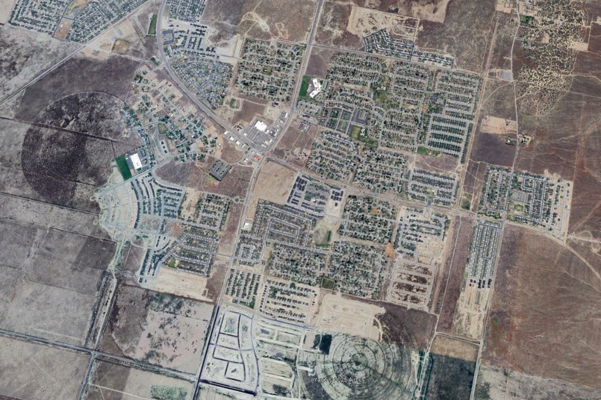
Urbanization of suburbs– green areas replaced by new developments:
Use of high-resolution satellite imagery
The use of high-resolution satellite imagery plays a key role in monitoring and managing urban development. Below are some applications of this technology, supported by concrete examples:
Identification of illegal construction: With the analysis of satellite imagery, it is possible to detect unauthorized construction projects, which is particularly important in the context of compliance with urban planning regulations
Urban planning: Investors use detailed satellite imagery to design new neighborhoods and assess existing infrastructure. Land cover analysis available on the OnGeo.pl Geoportal enables rapid generation of terrain reports to support planning processes.
Traffic optimization: Analysis of satellite imagery helps identify traffic congestion and develop new transportation solutions. For example, a study published in the journal Transportation Research Part C: Emerging Technologies found that the use of satellite imagery can significantly improve traffic management in cities.
Monitoring industries and economic zones: Satellite images make it possible to track the development of industrial zones and assess their environmental impact. OnGeo Intelligence reports provide satellite data for any location, which is useful for monitoring industrial activity.
Environmental Protection: Detailed satellite imagery allows monitoring of forest clearcuts and the effects of human activity on the natural environments of cities.
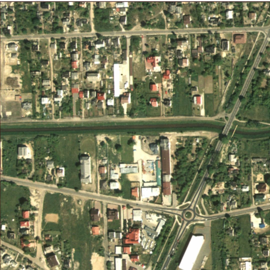
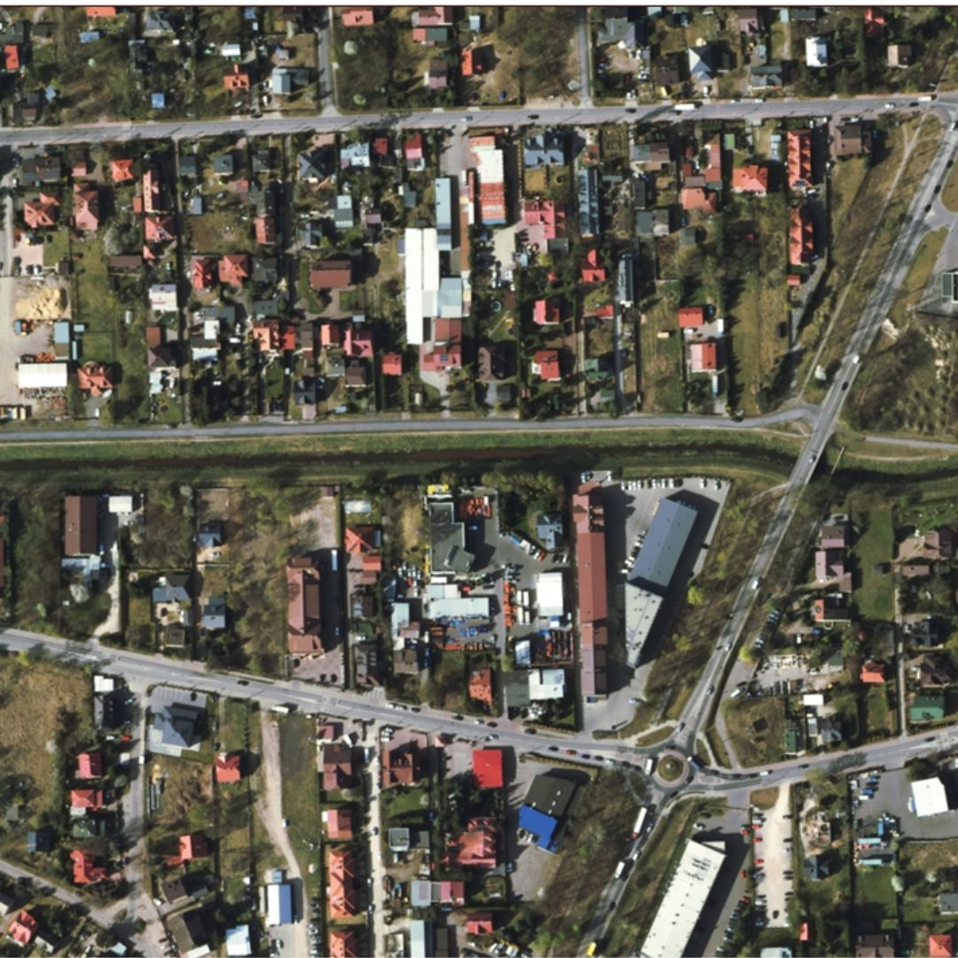
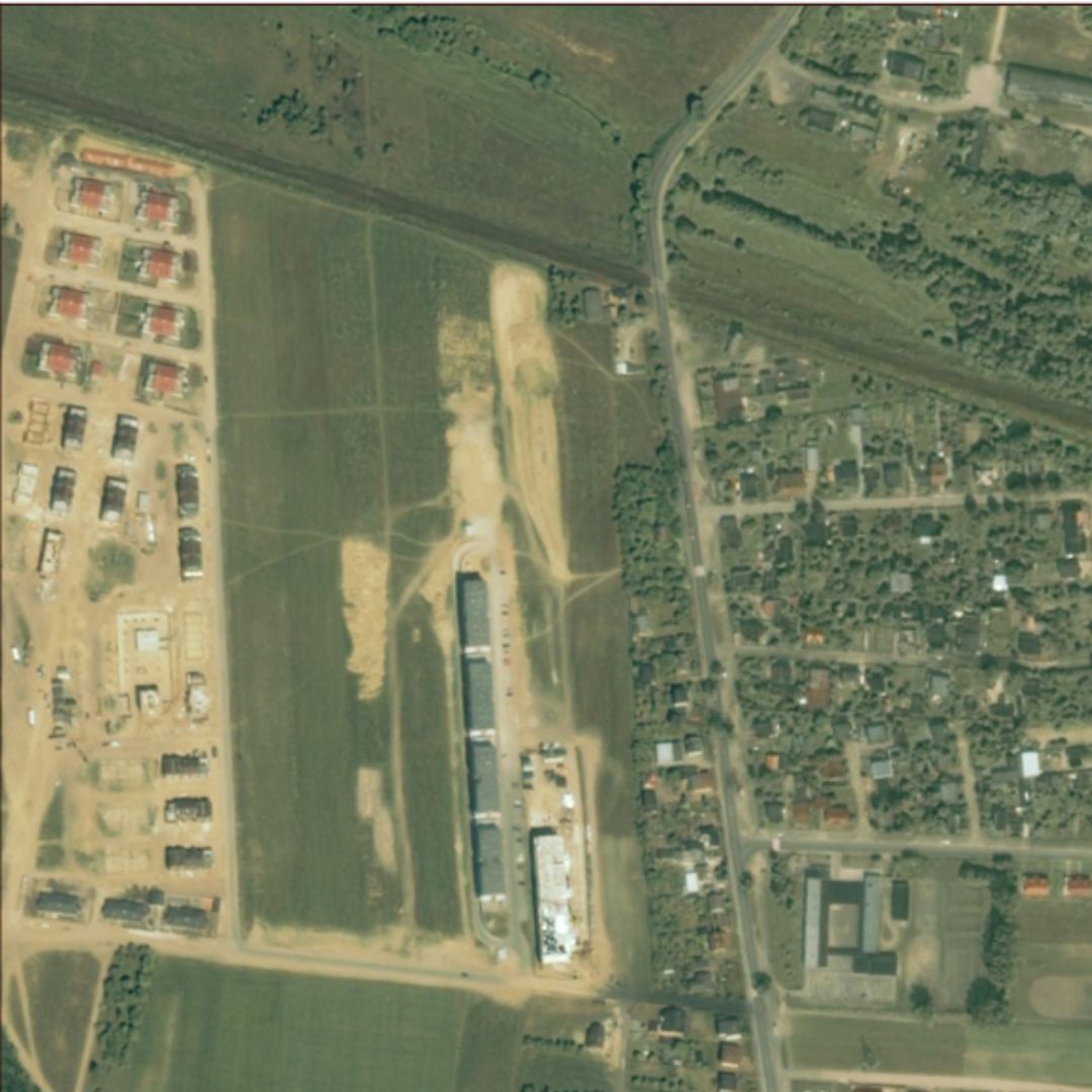
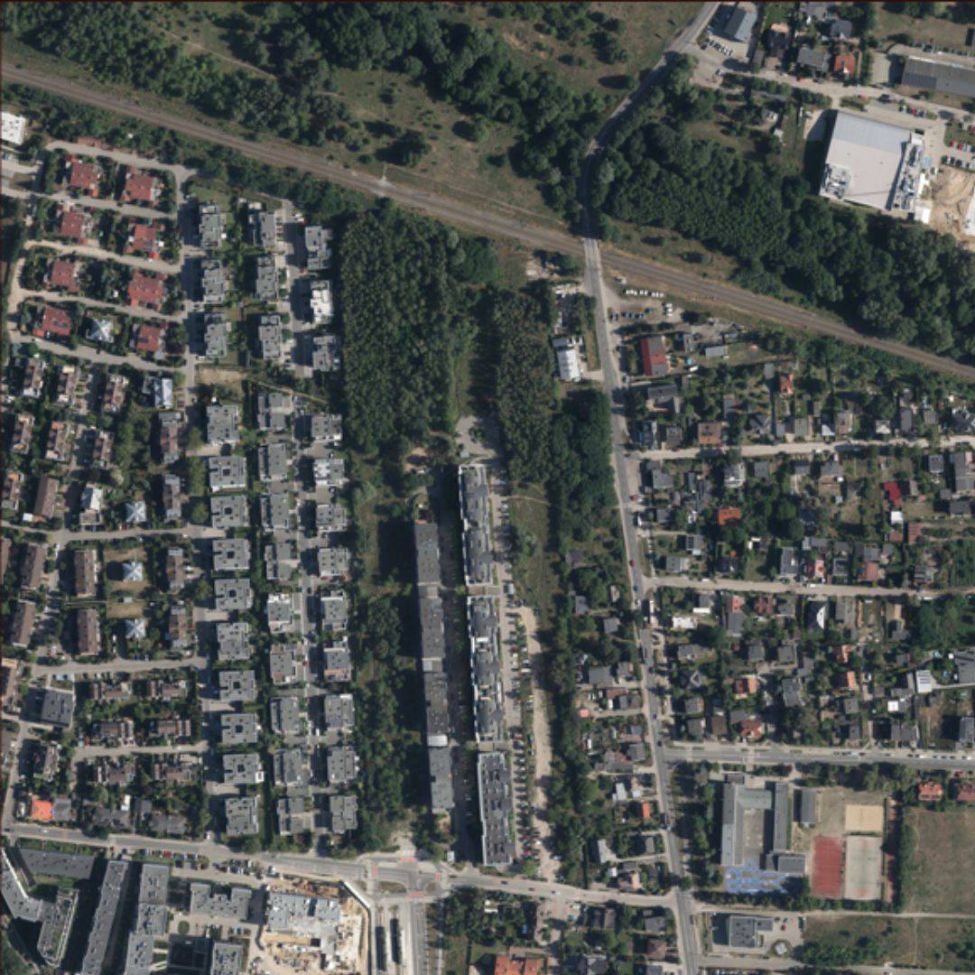
Urban Changes in Poland – Comparison of Satellite Images
Below is a comparison of satellite images of Poland from 2001 and 2024, showing dynamic changes in development and green areas:
Analyzing these two satellite images reveals significant spatial transformations. In 2001, this area was largely undeveloped, dominated by fields and a few single-family housing estates. Over more than two decades, the landscape has changed dramatically.
New residential complexes, expanded road infrastructure, and the extension of the tram line are among the key changes visible in the most recent image. The intensification of urban development has led to a significant increase in density, reflecting the city's rapid growth. At the same time, some patches of greenery have remained despite the expansion of urbanization.
By analyzing satellite images, it is possible to closely monitor such changes and assess their impact on the environment and residents' quality of life.
Thanks to satellite technology, we can better understand how Polish cities are changing and what factors are influencing their development. The OnGeo Intelligence platform combines reliable data from a variety of sources to offer reports from satellite imagery that simplify urban decision-making processes.
Want to learn more? Check out how satellite technology can help you analyze changes in your city!
Why Choose OnGeo Intelligence?
High-resolution imagery for precise analysis.
Reliable and verifiable data suitable for court use.
Comprehensive historical archives to support long-term investigations.
We use cookies to run our website, analyze your use of our services, manage your online preferences & personalize ad content. By accepting our cookies, you'll get relevant content and social media features, personalized ads, and an enhanced browsing experience. To manage your choices, click "Cookie Settings." Necessary cookies are required for the core website functionality and cannot be rejected. For more information, see our Cookie Policy.
About cookies on this site
Cookies used on the site are categorized. Below you can allow or deny some or all of them, except for Necessary Cookies which are required to provide core website functionality. When categories that have been previously allowed are disabled, all cookies assigned to that category will be removed from your browser.
Some cookies are required to provide core functionality. The website won't function properly without these cookies and they are enabled by default and cannot be disabled.
Preference cookies enables the web site to remember information to customize how the web site looks or behaves for each user. This may include storing selected currency, region, language or color theme.
Analytical cookies help us improve our website by collecting and reporting information on its usage.
Marketing cookies are used to track visitors across websites to allow publishers to display relevant and engaging advertisements. By enabling marketing cookies, you grant permission for personalized advertising across various platforms.
The cookies in this category have not yet been categorized and the purpose may be unknown at this time.