🌍 Capture the world at 100% OFF! Use code ongeo100on 10 meters satellite image resolutions – limited time only! Higher resolution satellite images remain subject to payment.
🌍 Capture the world at 100% OFF! Use code ongeo100on 10 meters satellite image resolutions – limited time only! Higher resolution satellite images remain subject to payment.
Pansharpening: The Secret to Sharper, More Detailed Satellite Images
2025-02-14
(Article updated:
2025-02-14
)
~ 4 min
Remote sensing has revolutionized how we monitor and analyze our planet. Yet, one fundamental limitation persists: the trade-off between spatial and spectral resolution. High-resolution satellite images often lack rich spectral detail, while multispectral images offer color depth but at lower resolution. Get to know pansharpening – a game-changing image fusion technique that combines the best of both worlds.
In this article, we’ll explore what pansharpening is, its history, why it’s crucial for GIS applications, the potential pitfalls and what the future holds for this innovative approach.
High-Quality Satellite Imagery, Hassle-Free
Explore any location on Earth with precision. Order a detailed Satellite Imagery Report—no sign-ups, no contracts. Delivered in a clear PDF for instant insights.
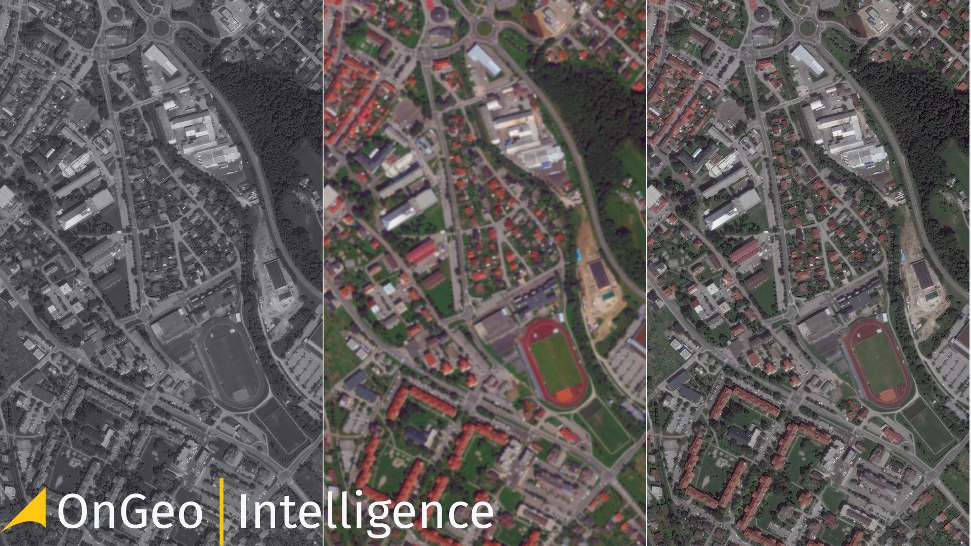
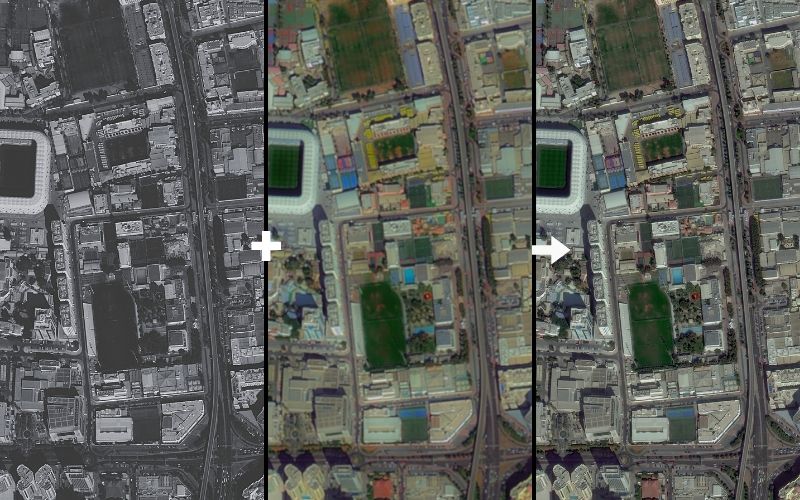
Pansharpening (short for panchromatic sharpening) is an image fusion technique used in remote sensing. It enhances the resolution of multispectral images by merging them with high-resolution panchromatic (grayscale) images. The result? A single, visually rich image that retains both high spatial detail and spectral accuracy.
Most Earth Observation satellites, such as Landsat, SPOT andWorldView, capture both panchromatic and multispectral images. The panchromatic band, which covers a broad range of wavelengths, provides finer spatial resolution, while multispectral bands capture the color information. Pansharpening fuses these two data sources to create a more detailed and informative image.
A brief history of pansharpening
The concept of pansharpening dates back to the 1970s and 1980s when satellites began capturing both panchromatic and multispectral imagery. Early image fusion techniques were developed to enhance spatial details while maintaining spectral accuracy. By the end of 1990s, methods such as the IHS transform and Brovey transformation gained traction, allowing researchers to merge images more effectively. Today, with the advent of machine learning and advanced image processing algorithms, pansharpening techniques have become even more sophisticated, providing higher-quality results with minimal spectral distortion.
Example image fusion and pansharpening
Why is pansharpening essential?
Satellite sensors face an inherent trade-off between spatial and spectral resolution due to technological constraints. A sensor can either:
Capture more spectral information across multiple bands (multispectral imagery) at a lower resolution, or
Focus on a smaller area and obtain higher resolution details in grayscale (panchromatic imagery).
Pansharpening bridges this gap by combining the sharpness of panchromatic images with the color depth of multispectral bands. This makes it an indispensable tool for: Urban Planning – Identifying buildings, roads, and infrastructure with greater clarity. Agriculture – Monitoring crop health and optimizing irrigation strategies. Environmental Monitoring – Tracking deforestation, water resource changes and pollution. Disaster Management – Assessing damage after natural disasters like hurricanes, floods and wildfires. Military & Intelligence – Improving reconnaissance and surveillance operations.
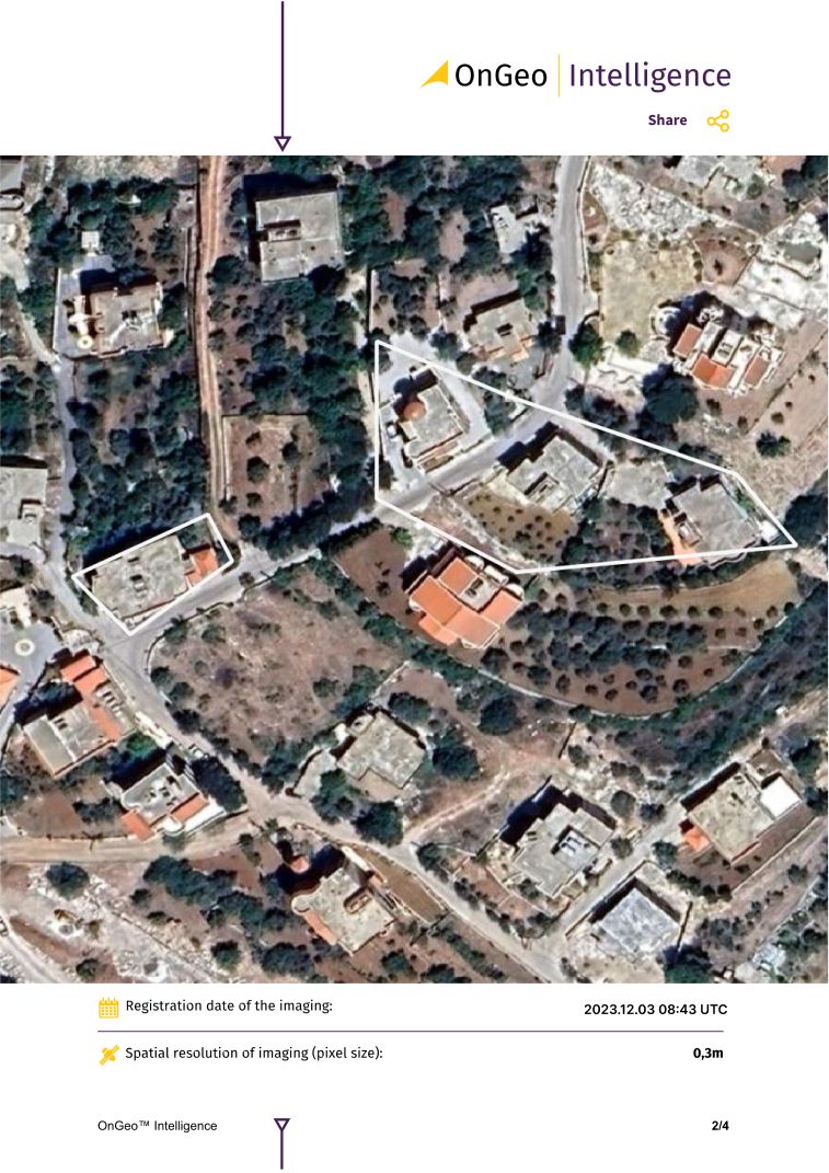
At OnGeo Intelligence, we offer fast and easy access to high-resolution satellite imagery reports, available globally. Whether for monitoring your property, supporting legal proceedings, or other applications, our service delivers precise satellite data quickly.
Key features include:
Global Reach: Request imagery from anywhere on Earth.
No Hassle: No account needed—simply select your area of interest.
High-Resolution Data: Get detailed imagery perfect for various uses.
PDF Format: Receive easy-to-read reports in minutes.
Experience quick, reliable satellite imagery reports today on OnGeo-Intelligence.com—no long-term commitments, just the data you need.
While pansharpening significantly enhances image quality, it is not without its challenges. Here are some key factors to consider:
Spectral Distortion – Some pansharpening methods can alter the original spectral characteristics, leading to inaccuracies in vegetation indices like NDVI (used in agricultural and environmental studies).
Mismatched Data – The panchromatic and multispectral images must be properly aligned; otherwise, artifacts and blurring can occur.
Choice of Algorithm – Different pansharpening methods produce varying results. Some prioritize visual appeal, while others focus on maintaining spectral integrity. Choosing the right algorithm depends on the intended application.
Computational Demands – High-resolution imagery requires significant processing power, especially when handling large datasets for GIS applications.
The future of pansharpening
As remote sensing technology advances, so too does the field of pansharpening. Emerging trends include:
Machine Learning & AI – Deep learning models are being trained to refine pansharpening results, reducing spectral distortions while preserving detail.
Super-Resolution Techniques –AI-powered deep lerning tools are able to increase the spatial resolution of multispectral bands to a level even higher than available within the panchromatic band.
Cloud-Based Processing – Platforms like for instance Google Earth Engine enable large-scale pansharpening, making high-quality imagery more accessible and cost-effective.
Better Sensor Technology – Future satellites may integrate improved multispectral sensors, reducing the need for pansharpening altogether.
To sum up
Pansharpening has transformed the way we interpret satellite imagery, providing a powerful tool for industries ranging from agriculture to urban planning. While it comes with challenges, ongoing advancements in AI and remote sensing will continue to refine this technique, ensuring even more accurate and insightful geospatial analysis.
We use cookies to run our website, analyze your use of our services, manage your online preferences & personalize ad content. By accepting our cookies, you'll get relevant content and social media features, personalized ads, and an enhanced browsing experience. To manage your choices, click "Cookie Settings." Necessary cookies are required for the core website functionality and cannot be rejected. For more information, see our Cookie Policy.
About cookies on this site
Cookies used on the site are categorized. Below you can allow or deny some or all of them, except for Necessary Cookies which are required to provide core website functionality. When categories that have been previously allowed are disabled, all cookies assigned to that category will be removed from your browser.
Some cookies are required to provide core functionality. The website won't function properly without these cookies and they are enabled by default and cannot be disabled.
Preference cookies enables the web site to remember information to customize how the web site looks or behaves for each user. This may include storing selected currency, region, language or color theme.
Analytical cookies help us improve our website by collecting and reporting information on its usage.
Marketing cookies are used to track visitors across websites to allow publishers to display relevant and engaging advertisements. By enabling marketing cookies, you grant permission for personalized advertising across various platforms.
The cookies in this category have not yet been categorized and the purpose may be unknown at this time.