From Space to Shore: How Earth Observation Satellites Help Monitor Water Quality
Satellite data is transforming the way we understand and protect freshwater and coastal ecosystems. From chlorophyll tracking in UK rivers to advanced geoportals in Poland, here’s how remote sensing brings clarity to our most vital resource.
Satellites Transforming Water Quality Monitoring
Monitoring water quality has traditionally been a laborious and localized proces – sampling from boats, transporting vials to labs, and analyzing results days or weeks later. Yet in recent years, Earth Observation (EO) satellites have brought a new paradigm to hydrological science, enabling researchers, public agencies and industries to monitor vast water systems in near real-time. Whether it’s chlorophyll surges in British rivers, turbidity in Italian lakes, or sediment plumes off Australian shores, satellites are now essential tools in understanding aquatic health. This article explores a selection of well-documented, operational examples of satellite data applications – especially using platforms like PlanetScope, Pléiades Neo and Sentinel-2 – to monitor water environments around the world, including some close to home in Poland.
Tracking Pollution from Space: Case Studies from the UK, Italy and Australia
One of the most illustrative examples of satellite-supported environmental research comes from the UK, where a study using Sentinel-2 data through the EO Browser and the Ulyssys Water Quality Viewer revealed high chlorophyll-a concentrations in rivers Thames and Severn. Chlorophyll-a, an indicator of phytoplankton biomass, often spikes in response to elevated nutrient levels – frequently linked to untreated sewage discharge. In this case, chlorophyll concentrations were observed increasing downstream of major sewage pumping stations, showing a strong spatial correlation. While these observations were not a substitute for direct chemical measurements, they provided a cost-effective way to assess pollution trends and raise public awareness.
Eyes in the Sky: How Satellites Revolutionize Aquatic Health Monitoring
A different approach was taken in Italy by the company Waterjade, whose WatQEO project demonstrated how Earth Observation could be used to estimate water quality in inland lakes, including Lake Garda. Using Sentinel-3 and Sentinel-1 data, combined with Copernicus Climate Data Store (C3S) and AI-powered modeling, WatQEO monitored variables like turbidity, chlorophyll and cyanobacteria concentration. The platform allowed users to visualize the status of the lake on demand and compare EO-based estimations against in-situ observations. Notably, it offered water utilities a scalable method to identify algal blooms and assess water suitability for treatment, without the need for high-frequency manual testing.
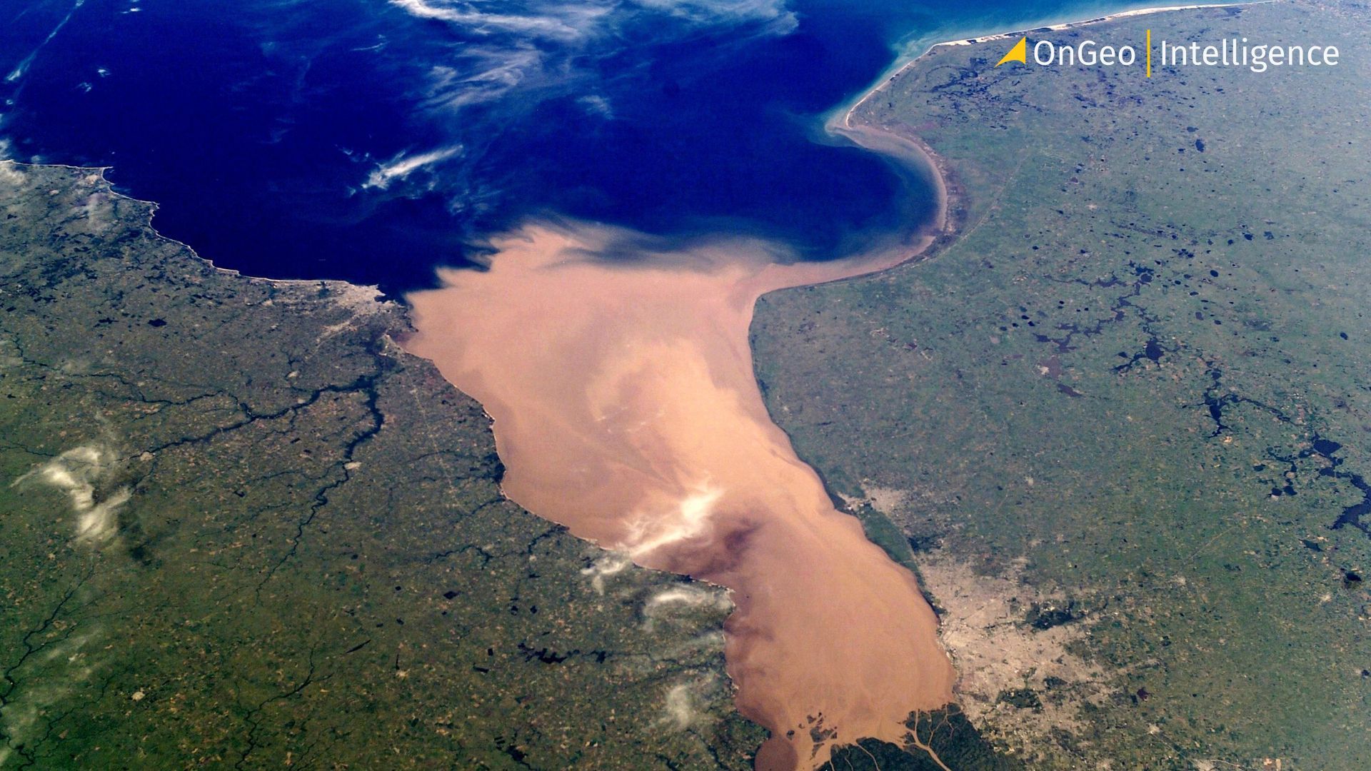
Sediment in the Sea: Australia’s 20-Year Coastal Water Data Cube
Beyond Western Europe, a powerful case study was carried out by CSIRO and the New South Wales Department of Planning and Environment in Australia. There, researchers developed a data cube integrating two decades of satellite observations – including Copernicus Sentinel-2 and other multisensor data – to analyze coastal water quality and sediment transport off the mouth of the Clarence River. The study revealed a steady decrease in euphotic depth – the upper layer of water where sunlight can penetrate to support photosynthesis – which has been shrinking by approximately 30 cm per year. The culprit? An increasing load of suspended sediments and dissolved organic matter entering the sea after extreme rainfall events and changing land use upstream. By analyzing the imagery before and after such events, scientists could pinpoint sediment plumes extending up to 30 km into the Tasman Sea. These insights have informed both conservation strategies and coastal planning. The findings are closely aligned with the goals of Copernicus Marine Service, which provides essential monitoring of marine environments.
Also read:
Smart Monitoring in Central Europe: Poland’s EO Geoportal
Closer to Central Europe, a cutting-edge project is underway in Poland to create a national geoportal for inland water monitoring. This initiative leverages Sentinel-2 imagery, processed using open-source Python libraries like Rasterio and GDAL, to detect parameters such as turbidity and chlorophyll concentration in rivers and lakes. Data is processed shortly after acquisition on CREODIAS, stored in Amazon S3 and visualized through a custom Web Map Service (MapServer/Mapbender). The goal? Provide public and scientific communities with an accessible, map-based tool for tracking water quality trends – especially in areas where field measurements are lacking due to budget or logistics constraints. The portal aims not only to enhance monitoring but also to drive civic engagement around environmental issues affecting Polish waters.
High-Resolution Satellites in Action: From Crisis Response to Wetland Mapping
High-resolution commercial satellite constellations are increasingly contributing to water-related Earth Observation. PlanetScope, known for its frequent revisit capabilities, has been instrumental in crisis response – notably providing detailed imagery during the severe flooding of the Kabul River in Pakistan. Similarly, Airbus’s Pléiades Neo constellation, offering sub-meter spatial resolution, is well-suited for monitoring small-scale water bodies, including narrow rivers, lakes and wetlands. While these satellites are often employed in urban development or land management, their spatial precision opens up opportunities for hydrological assessments – such as delineating water bodies, detecting illegal encroachments, or supporting post-disaster evaluation. Though not yet widely used for biochemical indicators like chlorophyll or turbidity, their very high-resolution optical data complements other EO missions in detailed surface monitoring.
Supporting Sustainable Development: EO in Marine Construction Projects
An entirely different yet complementary use case is the monitoring of suspended sediment concentrations during large-scale marine construction projects. In Western Australia, the Wheatstone LNG development leveraged both archived satellite data (dating back to 2000) and ongoing satellite observations to evaluate sediment plumes caused by dredging activities. By comparing baseline turbidity levels with current conditions during construction, environmental managers were able to quantify potential impacts and optimize dredging operations. This approach helped reduce environmental disturbance and supported compliance with regulatory requirements, offering a cost-effective method to assess and mitigate risks to nearby marine ecosystems.
Toward a Hybrid Future: The Promise and Limits of Satellite Water Monitoring
All these cases highlight a fundamental advantage of satellite-based water monitoring: scalability. A sensor in orbit can observe hundreds of kilometers of coast or river basin in a single overpass – something no boat or drone fleet can match. Additionally, multi-temporal satellite imagery allows long-term environmental trends to be established, offering insight not just into current conditions, but how they’re evolving under pressure from climate change, land use shifts and industrialization.
Of course, satellite-based monitoring is not without limitations. Cloud cover can obscure optical data, especially in temperate zones. Water quality parameters inferred from remote sensing – like chlorophyll or turbidity – are proxies, not direct chemical concentrations. Therefore, they are most powerful when combined with in-situ observations or models that calibrate and validate the remote sensing data. Nevertheless, when it comes to achieving comprehensive, affordable and consistent water monitoring at scale, EO remains a cornerstone.
From sewage tracing in British rivers to multi-sensor sediment analysis off Australian coasts and AI-enhanced water quality dashboards in Poland and Italy, it’s clear that satellites are no longer just watching Earth – they’re helping us protect it. As new missions continue to launch and remote sensing analytics evolve, the next wave of water monitoring tools promises even greater precision, insight, and impact.
Related articles
- Unlocking the Landscape: What Is Land Use/Land Cover (LULC) and Why Maxar’s BaseVue Is a Game-Changer
- Download the Satellite Map of Los Angeles – Free Printable PDF
- Test Our Satellite Data with a Free Satellite Imagery Report
- Spectral Bands: A Guide to Popular Index Formulas
- Monitoring air quality from space: Sentinel-4 Satellite Delivers First Data on NO2, SO2, and Ozone Levels in Europe