
Sentinel-6B Launched: New Climate Sentinel Takes Orbit to Track Accelerating Sea-Level Rise
Vandenberg Space Force Base, California - 17 November 2025 - The Copernicus Sentinel-6B satellite, the latest guardian of Earth’s oceans, was successfully launched aboard a SpaceX Falcon 9 rocket, ensuring uninterrupted high-precision monitoring of global sea-level rise through at least 2030.
Lift-off occurred at 21:21 PST (06:21 CET on 18 November) from Vandenberg Space Force Base. Just under one hour later, at 07:54 CET, ESA’s European Space Operations Centre in Darmstadt, Germany, received the first signal from the satellite via the Inuvik ground station in Canada, confirming that Sentinel-6B is alive, healthy, and beginning its mission.
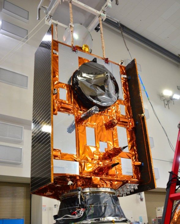
The Copernicus Sentinel-6B satellite
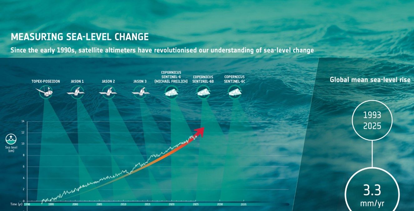
Built by Airbus as the identical twin of Sentinel-6 Michael Freilich (launched in November 2020 and also known as Sentinel-6A), Sentinel-6B carries the world’s most advanced radar altimeter to continue the climate-quality sea-surface height record that began in 1992 with TOPEX/Poseidon and the Jason series.
Why Sentinel-6B Matters Now More Than Ever
Global mean sea level is currently rising at 4.5-5 mm per year - a rate that has roughly doubled since the 1990s - threatening coastal cities, island nations, and ecosystems worldwide. The uninterrupted 40+ year data record that Sentinel-6B will help extend is considered the gold standard for climate science and is essential for:
- Accurate long-term sea-level rise projections
- Improved storm-surge and coastal flood warnings
- Better understanding ocean circulation and heat uptake
- Supporting adaptation strategies for millions living in vulnerable areas
- Validating and calibrating climate models used in IPCC reports
For the first 12-18 months, Sentinel-6B will fly in tandem with its still-operational predecessor Sentinel-6 Michael Freilich, just 30 seconds apart on the same orbit. This formation flying will deliver the most accurate sea-level measurements ever achieved, with global accuracy better than 1 cm for long-term trends.
Technical Highlights of Sentinel-6B
- Mass: ≈ 1.3 tonnes (some sources cite 1.5 tonnes including adapter)
- Orbit: Non-sun-synchronous, 1336 km altitude, 66° inclination - allowing observations at different times of day to capture tidal cycles and diurnal variations
- Primary instrument: Poseidon-4 radar altimeter (high-precision Ku/C-band) delivering centimetre-level sea-surface height measurements
- Secondary payload: Advanced Microwave Radiometer for Climate (AMR-C) supplied by NASA/JPL to correct for atmospheric water vapour delay
- Additional data: Significant wave height, wind speed over oceans, vertical profiles of atmospheric temperature and humidity
Sentinel-6B is placed on the historic reference orbit used since TOPEX/Poseidon, making it the official reference mission for global mean sea-level calculations.
International Partnership at Its Best
Although part of the European Union’s Copernicus programme, Sentinel-6 is a flagship example of transatlantic cooperation:
- European Commission – programme owner
- ESA – mission development and early operations
- EUMETSAT – long-term operations and data processing
- NASA/JPL – instruments, launch services, ground segment support
- NOAA – operational use and data distribution
- CNES – contributions to Poseidon altimeter
ESA’s Director of Earth Observation Programmes, Simonetta Cheli
“This achievement demonstrates what can be accomplished when international agencies and industries work together toward a shared goal. Sentinel-6B will ensure we continue to collect the high-precision data needed to understand our changing climate and protect coastal communities worldwide.”
Next Steps
Sentinel-6B is currently in its Launch and Early Orbit Phase (LEOP) under ESA control of ESA in Darmstadt. After commissioning (expected to take about six months), operations will transfer to EUMETSAT in late 2026. The first science data are anticipated in early 2026, with full operational data flow by mid-2026.
All Sentinel-6 data are provided free and open access worldwide through Copernicus services, supporting scientists, policymakers, maritime industries, and disaster-response agencies.
With Sentinel-6B now safely in orbit, the world gains another vital sentinel watching over our rising seas – exactly when we need it most.
Related articles
- Sentinel-1D Set for Launch Aboard Ariane 6 on November 4 to Strengthen Europe’s EO Capabilities
- From Maxar to Vantor: A New Era in Satellite Earth Observation and Geospatial Intelligence
- Satellite and Remote Sensing Terms You Should Know
- What is GEOINT? The Power and Limits of Geospatial Intelligence in the Modern World