
Satellite and Remote Sensing Terms You Should Know
Satellites and remote-sensing technologies are quietly transforming how we understand our planet - from monitoring forests and crops to mapping urban growth and autonomous system navigation. But if you’re new to this world, the specialised language can feel like a barrier. This glossary cuts through the complexity, explaining key terms and concepts in plain language so you can confidently follow geospatial, AI and Earth-observation conversations.
Key Terms to Know
1. Earth Observation (EO)
The collection of information about Earth’s physical, chemical and biological systems using satellites, aircraft or drones. EO data powers applications like agriculture optimisation, climate monitoring, disaster response and smart-city planning.
2. Remote Sensing
The science of obtaining information about objects or areas from a distance - typically via sensors on satellites or aircraft. These sensors detect reflected or emitted electromagnetic energy (visible, infrared, microwave) from Earth’s surface.
3. Landsat Program
The world’s longest-running Earth-observation satellite mission (since 1972, by NASA & US Geological Survey). Landsat satellites provide multispectral imagery at ~30-metre resolution every ~16 days, allowing long-term monitoring of land cover, vegetation, deforestation, etc.
4. Sentinel Satellites
A series of Earth-observation missions by the European Space Agency under the Copernicus Programme.
- Sentinel-1: Radar (SAR) – weather-independent imaging.
- Sentinel-2: Multispectral optical imagery – vegetation, land use.
- Sentinel-3: Ocean & land monitoring.
- Sentinel-5P: Atmosphere and air-quality monitoring.
Free and open for many users, making them essential in modern geospatial workflows.
5. Synthetic Aperture Radar (SAR)
A radar-imaging system that emits microwave pulses and measures the return. Because SAR works through clouds and at night, it’s invaluable for flood mapping, infrastructure change detection, terrain deformation and many disaster-use cases.
6. NDVI (Normalized Difference Vegetation Index)
A widely used vegetation health index derived from the red and near-infrared (NIR) bands of satellite imagery:
Values range from −1 to +1; higher values generally indicate healthier and denser vegetation. Commonly derived from Landsat, Sentinel-2, MODIS, etc.
7. MODIS (Moderate Resolution Imaging Spectroradiometer)
A sensor aboard NASA’s Terra and Aqua satellites capturing 36 spectral bands at ~250 m to 1 km resolution. Used for large-scale environmental monitoring — vegetation, ocean-colour, aerosols and climate trends.
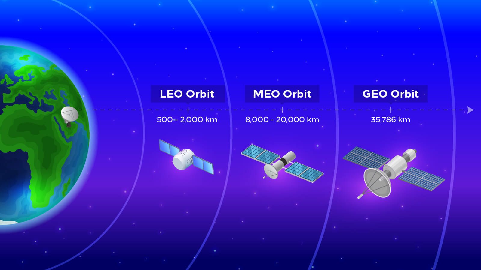
8. LEO (Low Earth Orbit)
Satellites orbiting between ~200 km and ~2,000 km above Earth. They complete orbits in ~90-120 minutes and are widely used for imaging, communications and Earth observation constellations (e.g., PlanetScope, Starlink, OneWeb).
9. GEO (Geostationary Orbit)
Satellites that orbit ~36,000 km above the Earth’s equator and appear fixed relative to the surface. Common for weather satellites, communications and broadcast services due to their continuous view of the same region.
10. Sun-Synchronous Orbit (SSO)
A near-polar orbit that passes over the same area of Earth at the same local solar time each day. Ensures consistent lighting conditions in imagery, which is crucial for time-series analysis and change detection.
11. Drone (UAV) Imagery
Unmanned Aerial Vehicles (drones) capture high-resolution, on-demand imagery at local scale. These imagery sources complement satellite data by offering detailed and flexible coverage for specific sites - in agriculture, construction or inspection use-cases.
12. Areal Imagery
Imagery taken from aircraft, balloons or other airborne platforms (lower altitude than satellites). These provide very high spatial resolution - often used in city planning, mapping or environmental surveys.
13. Resolution
A critical term in remote sensing:
- Spatial resolution: size of one pixel on the ground (e.g., 10 m, 30 m, 0.5 m).
- Spectral resolution: number and width of spectral bands captured by the sensor.
- Temporal resolution: how often a sensor revisits a given area.
- Radiometric resolution: the sensor’s ability to discriminate small differences in energy.
14. Spectral Bands
Specific ranges of the electromagnetic spectrum that sensors capture (e.g., blue, red, NIR, SWIR). Combining bands allows analysts to identify features or conditions invisible to the human eye (e.g., stressed vegetation, water-stress, soil moisture).
15. Image Stacking (Band or “Mock Stacking”)
The process of combining multiple spectral bands or multiple scenes (images) into a single composite image for analysis. For example, stacking Sentinel-2 bands (B4, B3, B2, plus B8) to create a multiband image that enables NDVI calculation. Temporal stacking (combining images over time) also helps generate cloud-free mosaics or track change.
16. Ground Station
A facility on Earth that communicates with satellites - receiving data (downlink) and sending commands or data (uplink). Ground stations are foundational to getting raw satellite data and transforming it into usable imagery or datasets.
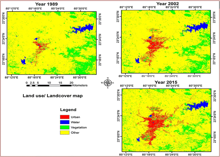
17. Temporal Analysis
Analyzing imagery from multiple dates to detect change - such as vegetation growth cycles, urban expansion, deforestation or post-disaster recovery.
18. Open Data Platforms
Platforms that provide free or open access to satellite/remote-sensing data:
- USGS EarthExplorer (for Landsat).
- Copernicus Open Access Hub (for Sentinel).
- NASA Earthdata (for MODIS and many others).
- Google Earth Engine (cloud-based large-scale analysis).
19. Footprint
The ground-area covered by a satellite image (in one pass). A larger footprint means more area covered but potentially less detail; a smaller footprint means higher detail but less area.
20. Calibration and Validation (Cal/Val)
Processes ensuring satellite sensors and imagery products are accurate and reliable. Calibration adjusts for sensor drift or atmospheric influences; validation involves comparing satellite data with field observations or reference datasets.
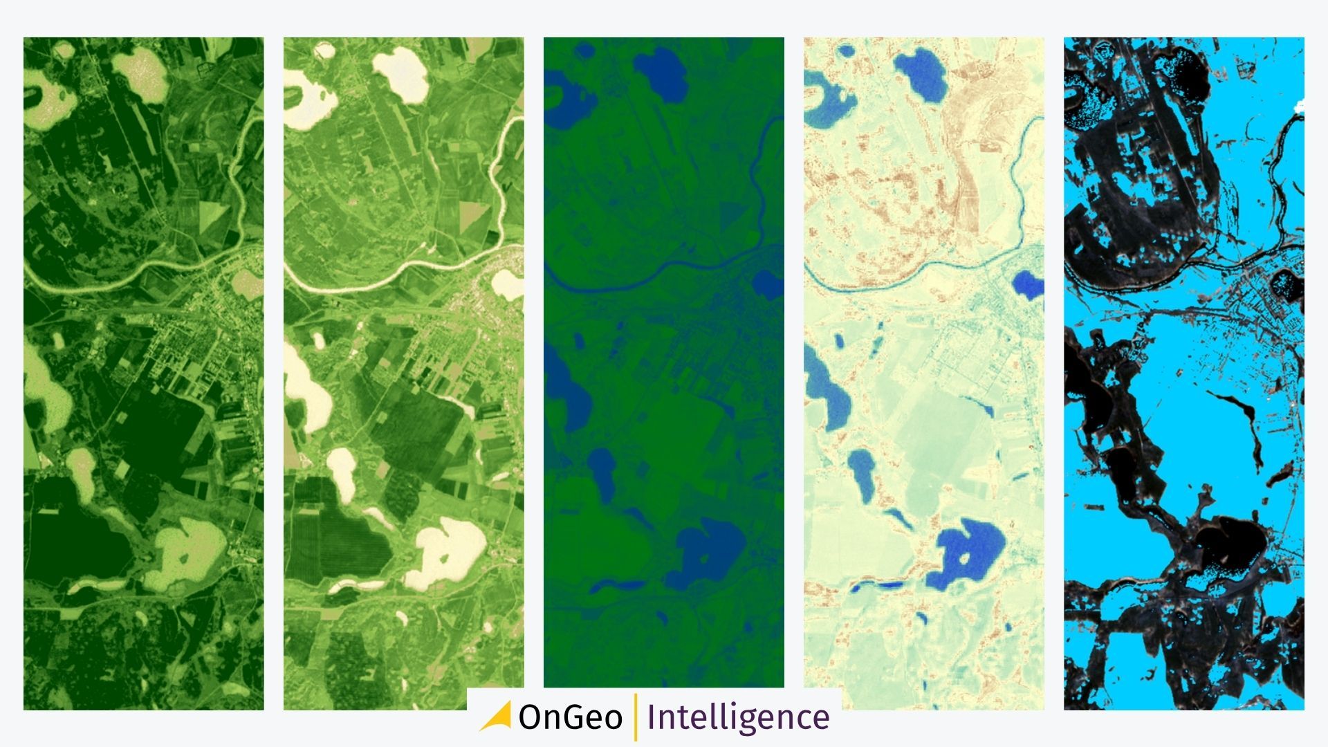
Spotlight: OnGeo Intelligence & Location Intelligence
OnGeo Intelligence is a global platform demonstrating how satellite imagery and location intelligence can be made accessible and actionable for everyone - from businesses to individuals. Their mission is simple: make satellite data usable, affordable, and fast to obtain.
Through their platform, users can select any location and time period, instantly browse available satellite archives, and order high-resolution imagery or reports. Depending on resolution and processing, results are typically delivered within minutes or up to 48 hours.
What sets OnGeo apart is its focus on clarity, speed, and transparency. Their imagery ranges from medium to ultra-high-resolution (down to ~0.3 m) and often includes AI-enhanced options for sharper detail and object detection. OnGeo provides both PDF report formats and raw data packages, enabling flexible use across industries.
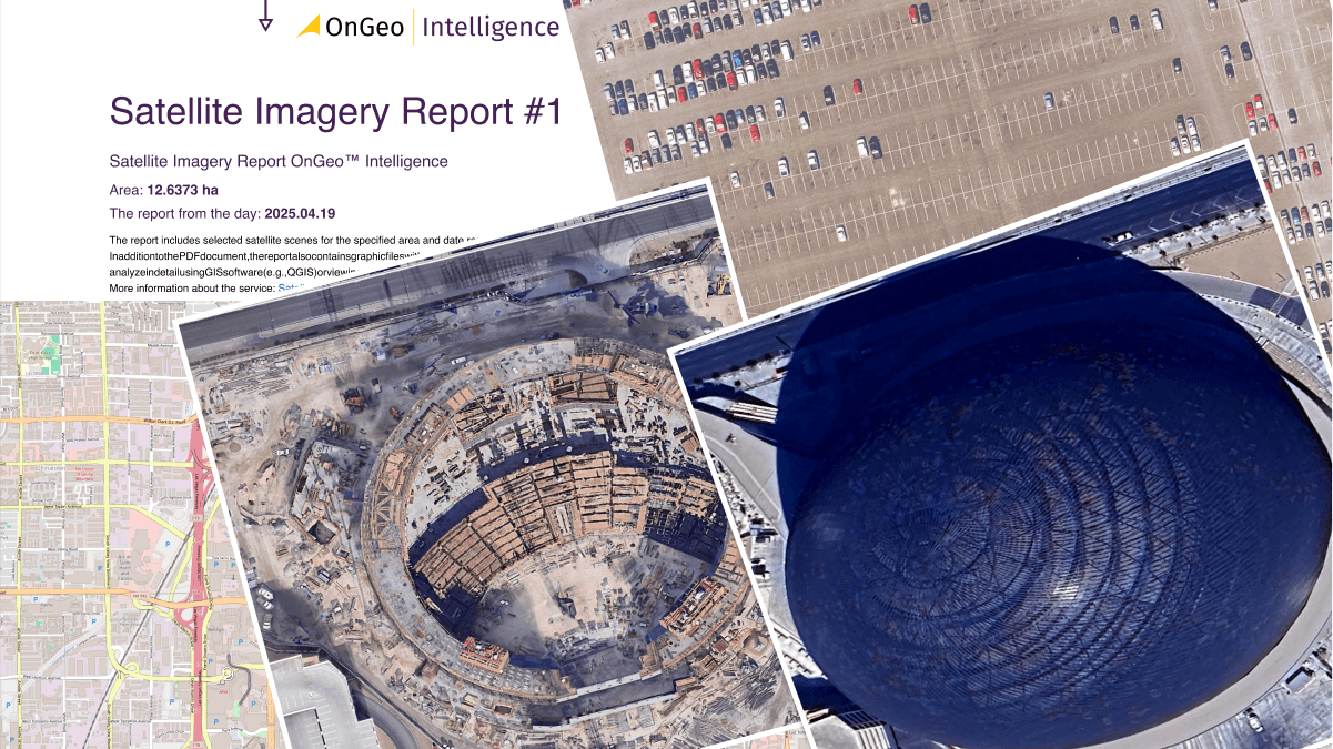
See sample Satellite Imagery Report
Use Cases Include:
- Environmental monitoring - tracking deforestation, pollution, or ecosystem changes.
- Agriculture - vegetation health analysis and field boundary mapping.
- Real-estate & legal - verifying property conditions, encroachments, and land-use changes.
- Disaster response - assessing flood, fire, or earthquake damage for rapid intervention.
Final Thoughts
The world of satellite imagery and remote sensing can seem technical at first, but platforms like OnGeo Intelligence prove that access and simplicity are possible. By bringing satellite insights closer to the end user, they are helping democratize Earth observation - transforming it from niche science into an everyday decision-making tool.
As you explore the terms in this glossary - from SAR and NDVI to mock stacking and LEO orbits - remember that each concept is part of a much bigger picture: a growing global ecosystem where space-based data fuels environmental awareness, business intelligence, and sustainable growth.
Satellite data is no longer about who can capture the most pixels - it’s about who can translate those pixels into understanding. And that’s exactly where platforms like OnGeo Intelligence are leading the way.