Unlocking the Past: How to Search for Historical Satellite Imagery
In an era where understanding change is key to informed decision-making, historical satellite imagery offers a powerful window into the evolution of our planet. From tracking urban expansion to monitoring environmental shifts, these archived images reveal patterns invisible to the naked eye. OnGeo Intelligence, simplifies this process with its user-friendly Satellite Imagery Report service. No technical expertise or subscriptions required - just point, search, and uncover the data you need. In this guide, we'll walk through how to leverage OnGeo's archives to hunt for past satellite photos, focusing on the search mechanics, available dates and resolutions, and real-world examples of tracking temporal changes.
Why Dive into Historical Satellite Archives?
Satellite imagery isn't just for the present; it's a time machine for landscapes. OnGeo Intelligence draws from vast global archives, including commercial and open-source constellations like Sentinel-2, to deliver cloud-free scenes from years past. Whether you're a farmer assessing crop history, an urban planner mapping development, or an environmentalist studying deforestation, these reports help you visualize "before and after" scenarios. The platform's strength lies in its accessibility: results arrive via email in minutes for low-res previews, with high-res details in under 48 hours, all packaged in a simple PDF.
Step-by-Step: Mastering the Search Process on OnGeo Intelligence
OnGeo's search engine is designed for efficiency, letting you query archives in real-time without endless scrolling. Here's how it works, emphasizing the discovery phase where you preview dates, resolutions, and image quality before committing.
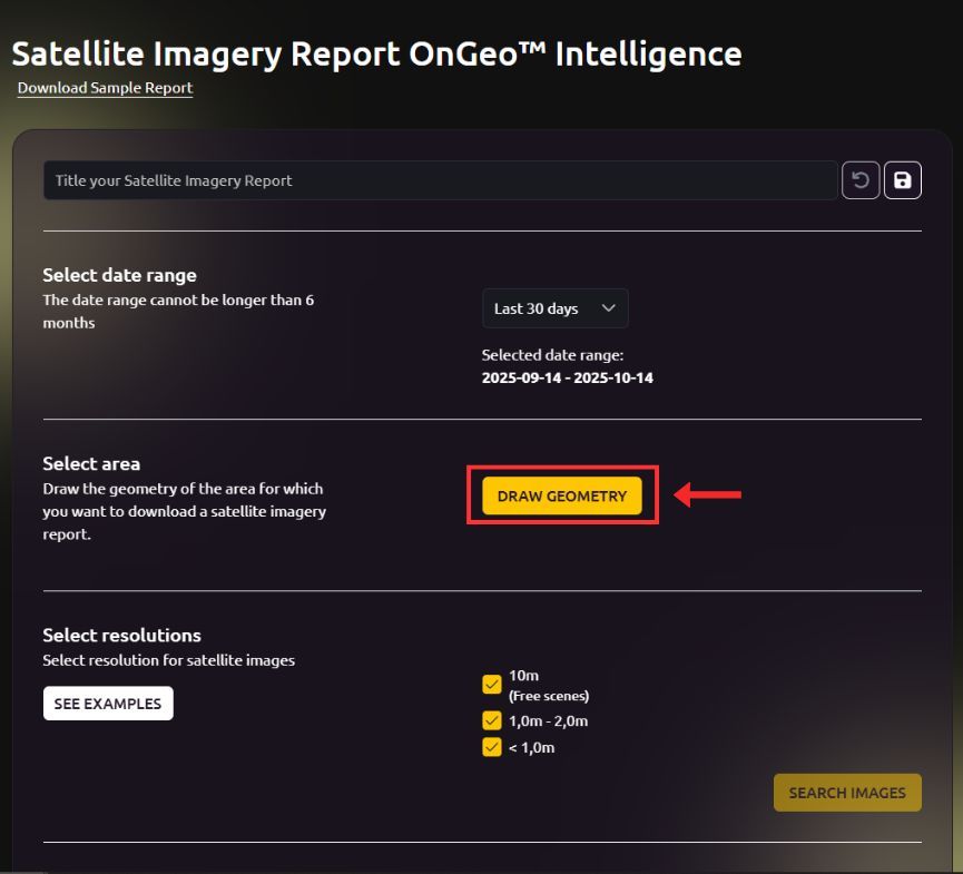
1. Define Your Query: Location and Time Period
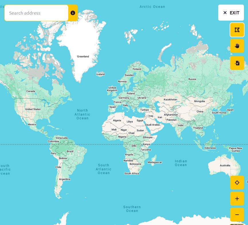
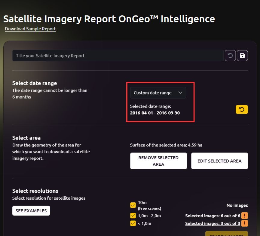
Start by pinpointing your area of interest on the interactive map. Zoom in on a specific plot of land, city, or region - OnGeo covers virtually the entire globe, from remote Madagascar bays to bustling Dubai skylines. Next, select your desired time frame. This could be a single date, a range (e.g., 2015–2020 for pre- and post-construction views), or even multi-year spans to spot seasonal or long-term trends.
The magic happens here: As you input these parameters, OnGeo instantly scans satellite archives. Within seconds, it generates a curated list of available cloudless images, filtered to match your criteria. No more guessing - the platform tells you upfront what's out there.
2. Explore Search Results: Dates, Resolutions, and Previews
This is where OnGeo shines in transparency. The results page displays of viable images, complete with metadata to help you evaluate options without ordering blindly.
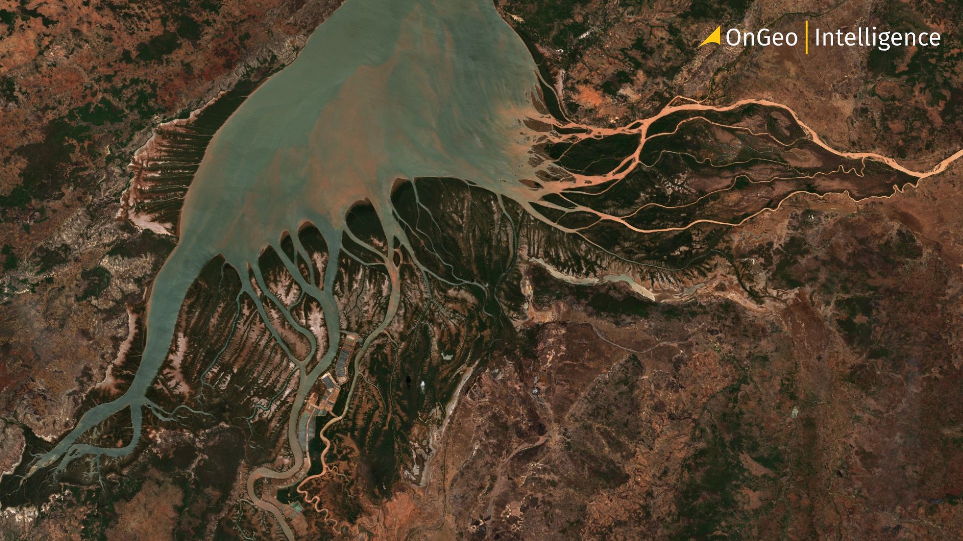
Available Dates: Images are timestamped precisely, often down to the day. For instance, searching a coastal site in Mahajamba Bay, Madagascar, might reveal captures 2023, 2024 and 2025 - spaced just right to track sediment buildup or waterway shifts over years. Gaps appear naturally if no cloud-free shots exist (e.g., during monsoon seasons), but OnGeo's algorithm prioritizes the closest matches, suggesting alternatives like nearby dates or adjacent orbits.
Resolutions and What They Reveal: Resolution dictates detail level, and OnGeo labels each result clearly so you can match it to your needs. Previews let you zoom in and assess visually - crucial for spotting if an image suits your analysis.
Each preview thumbnail is interactive: Hover to check cloud cover (aim for under 10% for clarity), off-nadir angles (straighter overhead shots are sharper), and even AI-enhanced previews that upscale lower-res images for better edge definition. If a date's resolution doesn't cut it - say, 10m won't show a new warehouse - you can refine your search for higher options or extend the date range.
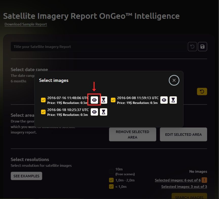
OnGeo Intelligence: Browse and Select Imagery. 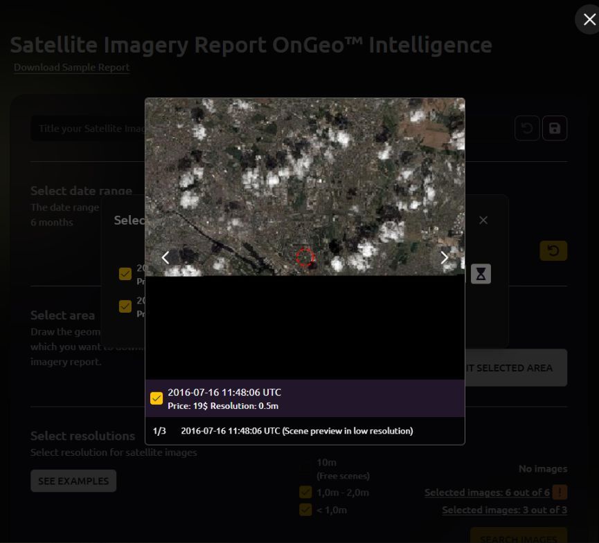
OnGeo Intelligence: Use the preview
3. Select, Order, and Receive
Once you've vetted the list, pick your top images (up to a bundle for multi-temporal views). Hit order, and voilà - your email pings in minutes with a low-res PDF preview. High-res follows within 48 hours, including:
- Chronologically sorted RGB (natural color) scenes.
- Indices like NDVI (vegetation health), NDWI (water detection), and NDMI (moisture) for quantitative change analysis.
- Optional ZIP of georeferenced Sentinel-2 files for deeper dives in tools like QGIS.
Pro tip: Always use the preview diligently - OnGeo buys images on-demand, so no refunds for overlooked clouds, but their filters minimize surprises.
Try it for free today Satellite Imagery!
Ready to experience the power of satellite data for yourself? We’re inviting you to test the waters with a free Satellite Imagery Report featuring 10-meter resolution imagery. Simply use the discount code ongeo100 at checkout. Please note that while this introductory offer lets you explore satellite data at no cost, high-resolution images (up to 0.3 m) remain part of our premium offering.
Tracking Changes Over Time: Real-World Examples
OnGeo's archives excel at temporal storytelling. Let's apply the search to two scenarios:
- Environmental Monitoring: Query a forested peninsula (e.g., an island with infrastructure) from 2010–2025 at 2m resolution. Results might show 2012 (dense canopy), 2018 (logging scars), and 2024 (regrowth). Side-by-side PDFs reveal erosion patterns or invasive species spread, with NDVI overlays quantifying green loss - vital for conservation reports.
- Urban Development Verification: For the Hudson Yards NYC area, search 2002–2025 at 0.3m VHR. Available dates cluster around construction milestones. Previews confirm clarity: high-res details builds and new roads. This verifies permit compliance or tracks illegal builds, all in a mobile-friendly PDF.
These examples highlight how OnGeo turns raw data into actionable insights, whether for quick verifications or long-term studies.
Why OnGeo Intelligence Stands Out for Historical Searches
Beyond the intuitive search, OnGeo offers global reach from diverse sources (Sentinel-2 for free archives), AI sharpening for hazy old shots, and zero barriers - no sign-ups, just instant access via phone or browser. It's empowering for non-experts while scalable for pros.
Ready to rewind the clock on your landscape? Head to OnGeo Intelligence and start your first search today. With archives spanning decades, the past is just a few clicks away - empowering decisions that shape the future.