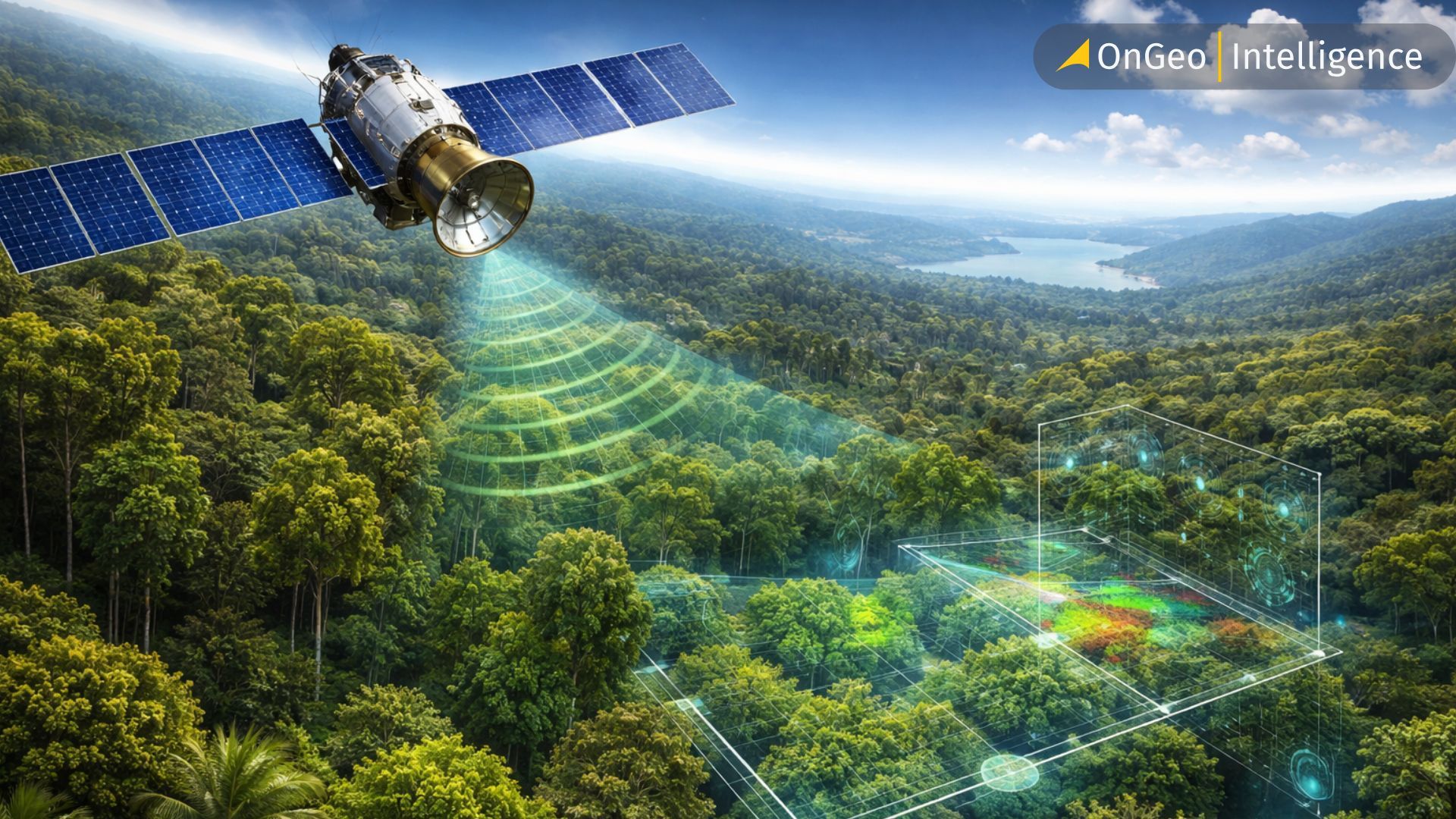
Satellite Forest Monitoring from Space: Global Tree Mapping with Satellite Earth Observation
The world’s trees are much more than just a backdrop for our landscapes; they are the fundamental pillars of our planet's survival, acting as carbon sinks, biodiversity havens and climate regulators. For decades, understanding exactly how many trees we have and where they are located was a Herculean task, often involving researchers physically trekking through dense jungles or counting trunks by hand in urban parks. Today, we are witnessing a paradigm shift as we move from the forest floor to the edge of space, enabled by satellite earth observation and advanced satellite imagery.
Satellite Earth Observation for Global Tree Mapping and Forest Monitoring
Satellite Earth Observation (EO) has transformed from a niche scientific tool into a global monitoring powerhouse, allowing us to map the Earth’s green canopy with a level of detail that was once the stuff of science fiction. By leveraging a sophisticated array of optical sensors, radar technology and the burgeoning power of artificial intelligence, we are finally gaining a truly comprehensive view of our terrestrial ecosystems.
This blog post explores the complex world of satellite-based tree mapping and satellite forest monitoring, the synergy of different data sources and how cutting-edge technology is helping us protect our most precious natural resources.
Optical Satellite Imagery for Tree Mapping and Long-Term Forest Monitoring
At the heart of modern tree mapping lies optical and optoelectronic satellite imagery, which capture the sunlight reflected off the Earth's surface across different wavelengths. When we talk about these data, the most critical factor to consider is spatial resolution - the size of the smallest detail a satellite can "see." For broad, national, or global assessments, medium-resolution data from programs like Landsat or Sentinel-2 are the gold standard.
Landsat, with its thirty-meter resolution, provides an invaluable historical archive stretching back to the 1970s, making it the perfect tool for tracking how forests have changed over decades. However, thirty meters is often too "blurry" to see individual trees. This is where Sentinel-2 shines; with its ten-meter resolution and specialized spectral bands designed to detect vegetation health, often called the "red edge," it provides a much sharper picture of forest density and vitality. For specialized applications like urban planning or monitoring small-scale plantations, we turn to high-resolution sensors like WorldView or PlanetScope. These satellites provide ultra-high-resolution satellite imagery,, allowing us to map individual tree crowns in a crowded city or support detailed satellite forest monitoring in agroforestry systems.
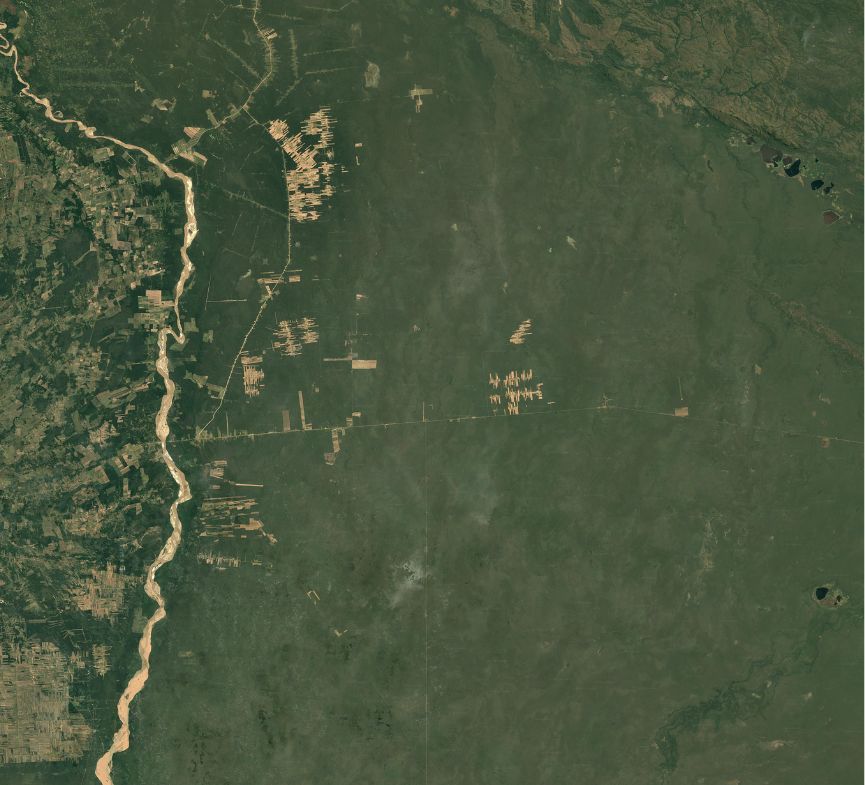
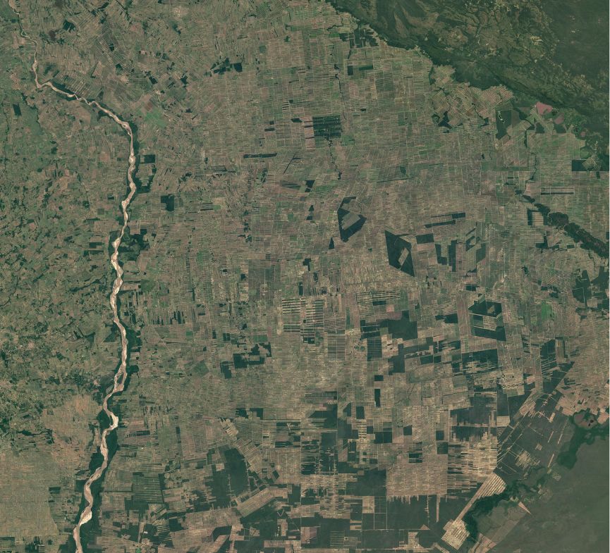
Satellite Forest Monitoring of Deforestation in the Bolivian Amazon
Satellite Earth Observation data clearly shows the rapid loss of forest cover in the Bolivian Amazon. Time-series imagery reveals how dense tropical forests are being transformed into fragmented landscapes, with serious consequences for biodiversity, indigenous communities and the global carbon cycle. This example highlights the critical role of satellite forest monitoring and satellite earth observation in understanding and responding to deforestation at scale.
All-Weather Satellite Forest Monitoring Using SAR and Radar Imagery
While optical data are incredibly powerful, they have one major weakness: they cannot see through clouds. In tropical regions, where tree cover is most critical, persistent cloud cover can hide the ground for months at a time. This is where the concept of data fusion becomes a game-changer.
By supplementing optical satellite imagery with Synthetic Aperture Radar (SAR) data, such as that provided by the Sentinel-1 or ALOS PALSAR missions, we can effectively "pierce" the clouds. Radar works by sending its own microwave signals to the ground and measuring the echo that bounces back. Because these signals are not affected by weather or light conditions, radar provides a consistent stream of information regardless of the season. But the true magic happens when we combine the two.
Optical data give us the "color" and "health" of the leaves, while radar provides structural information about the "skeleton" of the forest - the density of the branches and the volume of the biomass. This fusion creates a multidimensional map that is far more accurate than anything a single sensor could produce alone, allowing us to distinguish between a dense natural forest and a young palm oil plantation that might look similar from a simple color photograph.
Satellite Earth Observation in Practice: National-Scale Tree Mapping in Mexico
The practical impact of this technology is best seen through real-world applications, such as the work being done in Mexico. The Mexican landscape is incredibly diverse, ranging from lush tropical rainforests in the south to arid and fragmented dry forests in the north. This diversity makes consistent, up-to-date mapping challenging, especially where tree cover is heterogeneous or mixed with other land uses. To address this, researchers have leveraged Sentinel-2 optical imagery combined with local secondary data.
This approach allowed the team to produce high-resolution land cover maps, including a 2018 baseline for the national Greenhouse Gas (GHG) inventory and a specialized 10-meter Tree Cover Density layer from 2020. This density layer can be thresholded, meaning users can convert it into “tree/no-tree” products aligned with specific monitoring or reporting definitions. Today, these satellite earth observation-derived layers are being delivered in usable formats to support Mexico’s national tree mapping and forest monitoring workflows. By improving planning, reporting and the operational uptake of satellite data within national institutions and climate-finance-related programs, this level of detail supports more robust tracking of environmental progress and related commitments.
The Mexican Caribbean from Above
AI-Powered Satellite Imagery and Earth Observation for Accurate Tree Mapping
Despite having vast amounts of satellite imagery and Earth Observation data, the sheer volume of information coming from space is overwhelming for human analysts. This is where Artificial Intelligence (AI) and Machine Learning become indispensable. AI acts as a "force multiplier," processing millions of pixels in seconds to identify patterns that the human eye might miss. One of the biggest challenges in remote sensing is the "mixed pixel" problem, when a single pixel contains a bit of tree, a bit of soil, and perhaps a bit of grass.
Advanced AI algorithms, such as Convolutional Neural Networks (CNNs), are specifically designed to solve this by analyzing the spatial context of pixels, essentially learning what a "tree pattern" looks like from above. Furthermore, we are now entering the era of Generative AI (GenAI) and Explainable AI (XAI) in Earth Observation. GenAI can be used to "fill in the gaps" left by clouds by simulating what the missing ground data likely looks like based on historical patterns. Meanwhile, XAI helps scientists understand why an algorithm classified a certain area as a forest, ensuring that the results are not just accurate, but also transparent and trustworthy for policymakers.
The Future of Satellite Forest Monitoring: Near-Real-Time Tree Mapping from Space
The future of tree mapping and satellite forest monitoring is not just about having better cameras in space, but about intelligently combining satellite imagery, radar data and AI. We are moving toward "virtual constellations" where data from different international satellite missions are harmonized into a single, seamless stream of information. This allows for near-real-time monitoring, where a forest manager could receive an alert on their phone the moment a new patch of trees is cleared or a fire starts. The combination of high-resolution optical data, all-weather radar and sophisticated AI models is turning the dream of a "live" map of the world’s trees into a reality. As these tools become more accessible and simpler to use, they empower not just scientists, but also local communities and governments to take active roles in land management.
Related articles
- Satellite Imagery Reveals M23’s Environmental Destruction in Eastern DRC
- Monitoring air quality from space: Sentinel-4 Satellite Delivers First Data on NO2, SO2, and Ozone Levels in Europe
- Unlocking the Past: How to Search for Historical Satellite Imagery
- The Atlantic Forest Deforestation: South America's Silent Drama Seen from Space
- How to Obtain Satellite Imagery of Your Plot? OnGeo Intelligence Guide
- From Space to Shore: How Earth Observation Satellites Help Monitor Water Quality