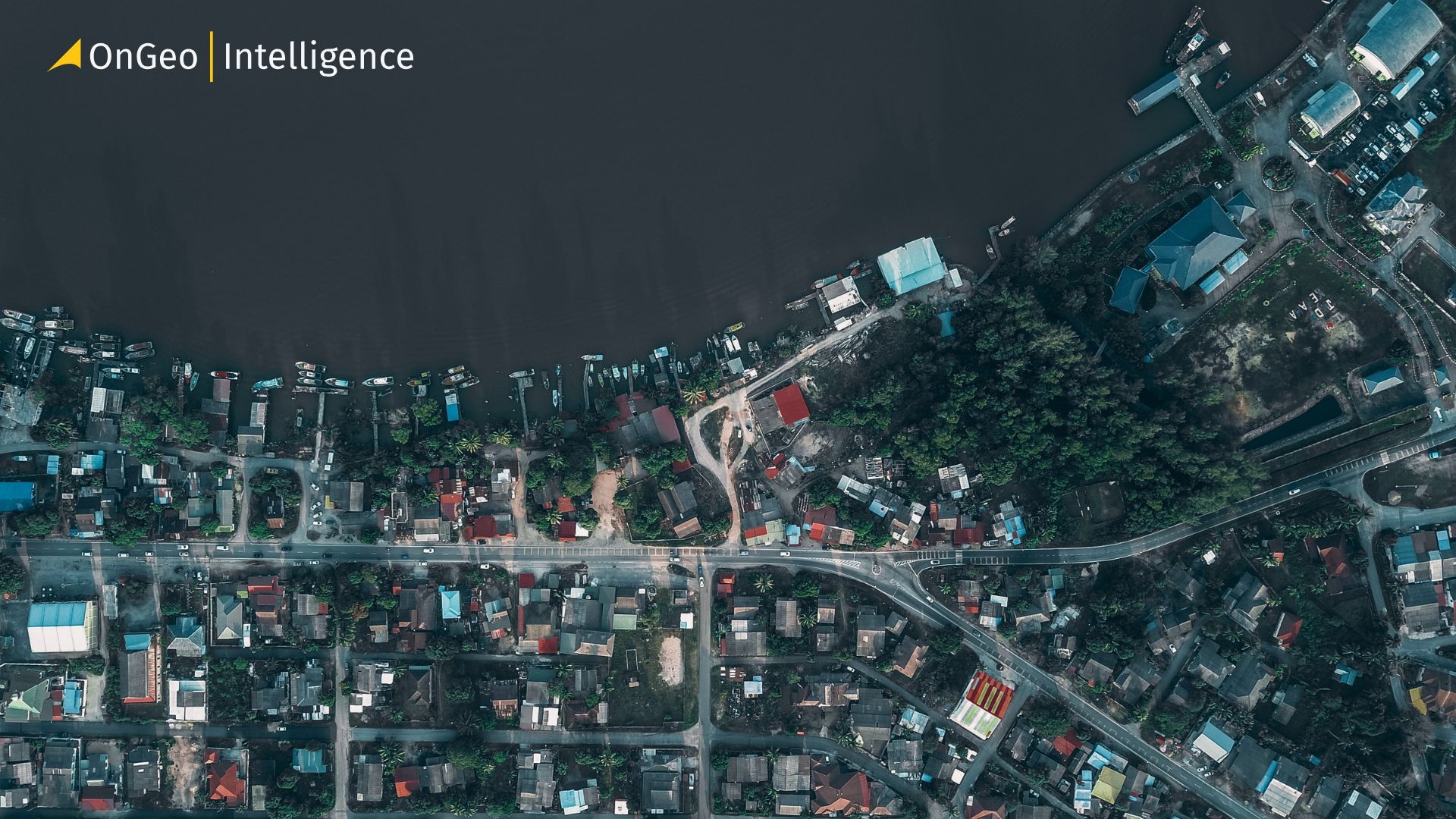
Urban Planning with High-Resolution Imagery
As cities evolve, urban planners need reliable and up-to-date data to support informed decision-making. High-resolution satellite imagery provides a faster and more cost-effective alternative to traditional surveys, offering a comprehensive view of urban environments. By analyzing satellite data, planners can monitor land use, track development, assess infrastructure needs, and improve environmental resilience. This technology supports smarter, more sustainable, and climate-adaptive urban planning.
How Satellite Imagery Supports Urban Planning
Satellite imagery provides urban planners with a comprehensive, up-to-date view of cities that is difficult to achieve through ground-based surveys alone. By capturing consistent imagery across large areas, satellites allow planners to analyze how cities grow, change, and function over time.
High-resolution images help identify land-use patterns such as residential expansion, commercial development, industrial zones, and green spaces. This visibility supports better zoning decisions and helps ensure that development aligns with planning regulations.
Satellite data also enables time-series analysis, allowing planners to compare historical and recent images to track urban expansion, densification, and infrastructure development. These insights support long-term planning, infrastructure investment decisions, and sustainable city growth strategies.
Beyond physical development, high-resolution satellite imagery is a cornerstone for enhancing urban equity and public health. By overlaying socioeconomic data with spatial imagery, planners can identify "service deserts" neighborhoods lacking adequate access to parks, grocery stores, or public transit.
This allows for a more surgical approach to resource allocation, ensuring that marginalized areas receive the infrastructure upgrades they need most. When cities visualize these disparities from a "bird's-eye view," it becomes much easier to design interventions that foster social cohesion and improve the quality of life for every resident, regardless of their zip code.
Assessing Urban Expansion and Land Use
Satellite imagery allows urban planners to monitor how cities expand and how land is being used across metropolitan areas. High-resolution images make it possible to distinguish between residential, commercial, industrial, and mixed-use developments, providing a clear picture of urban structure.
By comparing imagery over time, planners can identify patterns such as urban sprawl, densification, and infill development. This helps cities manage growth more effectively, ensuring that expansion aligns with zoning regulations and long-term development plans.
Satellite data is also valuable for detecting informal or unplanned settlements and monitoring land-use changes in rapidly growing areas. These insights support proactive planning decisions, helping authorities balance development needs with infrastructure capacity and environmental considerations.
Moreover, the granularity of high-resolution imagery is a game-changer for protecting urban biodiversity and managing the "urban-rural fringe." As cities push outward, satellite data acts as a digital boundary, allowing planners to monitor encroachment into protected wetlands, forests, or agricultural belts in real-time.
By utilizing Automated Change Detection (ACD) algorithms, municipalities can receive instant alerts when unauthorized clearing or construction begins in sensitive zones. This level of oversight ensures that urban expansion doesn't come at the cost of essential ecosystem services, helping cities maintain a "green lung" that regulates local climates and preserves natural habitats amidst ongoing densification.
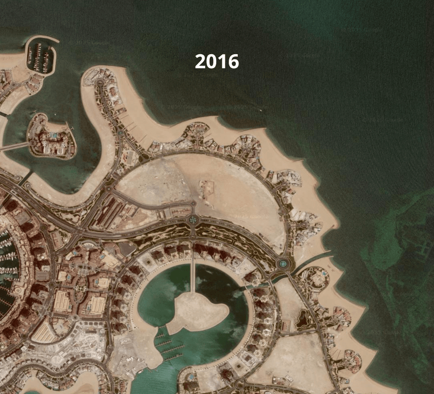
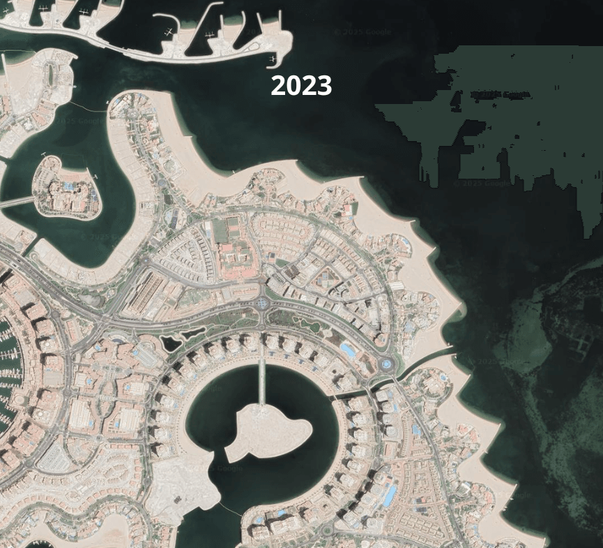
From 2016 to 2023: Doha Medina Centre Transformed
Environmental and Green Space Monitoring
Satellite imagery supports urban planners in monitoring environmental conditions and green spaces within cities. High-resolution data makes it possible to map parks, urban forests, wetlands, and other natural areas, helping planners understand how green infrastructure is distributed across urban environments.
Time-series satellite imagery allows cities to track changes in vegetation cover, identify loss of green spaces due to development, and evaluate the effectiveness of urban greening initiatives. These insights are essential for managing urban heat islands, improving air quality, and supporting climate resilience.
By integrating environmental monitoring into urban planning workflows, satellite data helps cities balance development with sustainability goals, ensuring healthier and more livable urban spaces for growing populations.
Building on this integration, satellite monitoring also provides a critical lens for environmental justice and social equity. In many metropolitan areas, the distribution of green space is historically uneven, often leaving lower-income neighborhoods with higher proportions of heat-retaining concrete and fewer natural cooling zones.
By utilizing Normalized Difference Vegetation Index (NDVI) data, planners can pinpoint "nature-deprived" sectors and prioritize them for new park developments or tree-planting programs. This data-driven approach ensures that the benefits of green infrastructure such as reduced energy costs, better mental health outcomes, and flood mitigation are accessible to all residents, transforming satellite imagery from a simple mapping tool into a powerful instrument for social and ecological advocacy.
Risk Assessment and Resilience Planning
Satellite imagery is a cornerstone of modern disaster risk reduction (DRR), allowing planners to move beyond historical guesswork toward predictive modeling. By integrating high-resolution topographic data with hydrological models, cities can simulate flood inundation scenarios with exceptional precision, identifying exactly which blocks or critical facilities such as hospitals and power substations are at risk. This spatial intelligence enables the design of "sponge city" infrastructure, where green roofs and bioswales are strategically placed based on analyzed runoff patterns.
Satellite imagery is a cornerstone of modern disaster risk reduction (DRR), allowing planners to move beyond historical guesswork toward predictive modeling. By integrating high-resolution topographic data with hydrological models, cities can simulate flood inundation scenarios with exceptional precision, identifying exactly which blocks or critical facilities such as hospitals and power substations are at risk. This spatial intelligence enables the design of "sponge city" infrastructure, where green roofs and bioswales are strategically placed based on analyzed runoff patterns.
Proactive Resilience Strategies
- Urban Heat Island (UHI) Mitigation: Thermal infrared sensors identify "hot spots" where lack of vegetation and heat-absorbing materials drive up local temperatures. Planners use this to prioritize "cool pavement" initiatives and tree-planting programs.
- Seismic and Subsidence Monitoring: Using Interferometric Synthetic Aperture Radar (InSAR), planners can detect millimeter-scale shifts in the earth's surface, flagging potential structural risks to bridges, tunnels, and skyscrapers before visible cracks appear.
- Coastal Protection: For seaside metropolises, satellite data tracks erosion rates and sea-level rise, informing the construction of sea walls or the restoration of protective mangroves.
How OnGeo Intelligence Supports Urban Planning Workflows
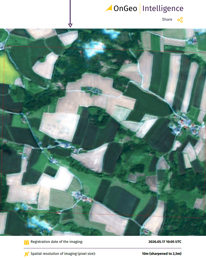
OnGeo Intelligence helps urban planners access high-resolution satellite imagery and spatial data for faster, data-driven decision-making. The platform enables users to analyze current and historical imagery, monitor land use and infrastructure changes, and compare urban development over time.
With easy-to-use visual tools and shared geospatial insights, OnGeo Intelligence improves collaboration between planners, policymakers, and stakeholders. It also supports sustainable urban development by helping identify environmental risks such as flood-prone areas, heat islands, and green space loss early in the planning process.
With the exclusive code ongeo100, you can generate professional free satellite imagery reports, including graphs showing changes in NDVI, NDMI, and NDWI values.
Follow these simple steps to generate your free report:
- Visit OnGeo Intelligence
- Use the interactive map on the order form to select your area of interest and specify your desired date range.
- Browse the available scenes (the platform checks multiple sources). Add desired 10m resolution scenes to your cart.
- Apply code ongeo100 during checkout.
- Receive your Satellite Imagery Report via email in minutes!
Why This Matters for Growing Cities
As cities expand, planning decisions become more complex and the cost of getting them wrong increases. Rapid urban growth can strain infrastructure, reduce green spaces, and create long-term environmental and social challenges if not carefully managed.
Satellite imagery gives city planners a reliable, up-to-date view of how urban areas are changing in reality not just on paper. By understanding where and how cities are growing, planners can make better decisions around zoning, transportation, housing density, and environmental protection. This leads to more resilient, efficient, and livable cities that are better prepared for future growth.
The adoption of satellite-based planning fosters transparency and public trust in urban governance. When city officials can present clear, visual evidence of land-use changes such as the depletion of a local watershed or the success of a new transit corridor it bridges the communication gap between technical experts and the general public. This democratized data allows citizens to better understand the rationale behind complex zoning shifts or tax allocations, turning urban planning into a more collaborative process. By grounding policy in objective, visible reality, cities can minimize political friction and ensure that long-term sustainability goals remain on track even as local administrations change.
Related articles
- Satellite Imagery for Agriculture: Crop Monitoring Guide
- Detection of Illegal Construction in Satellite Images
- Essential Tips for Interpreting Satellite Imagery Like a Pro
- Earth Observation: How Satellite Views of Your House Are Now at Your Fingertips
- Investment Planning from a Bird's Eye View: Land Analysis Using Satellite Imagery
- Detecting Unregistered Properties with AI & Satellite Imagery