Amazon Deforestation: What Satellite Reports Reveal
Amazon - the green lungs of the planet in critical conditionAmazonia is the planet's largest and most diverse forest, and its existence affects the Earth's climate situation. The vegetation of the Amazon forest absorbs billions of tons of CO₂ and is home to countless animal species. Despite its invaluable ecological value, more square kilometers of forest are being degraded every year. The scale of deforestation in the Amazon is best illustrated by satellite images that show degraded areas.
Satellites as a tool of truth - how do we depict deforestation in the Amazon?
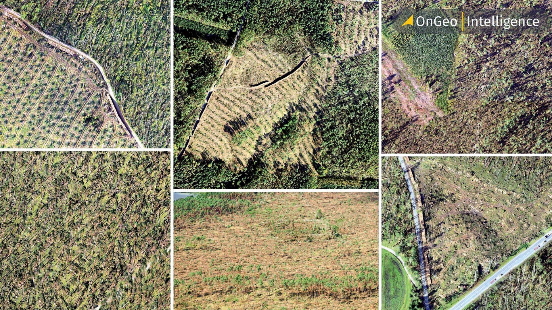
At OnGeo Intelligence, we analyze and provide satellite reports showing environmental changes with high accuracy. For Amazon rainforest areas, it is possible to compare “before and after” images - taken at intervals that the user can freely select.
Through the use of remote sensing indices, such as the Normalized Difference Vegetation Index (NDVI), we can measure changes in vegetation condition and accurately pinpoint areas at risk or already degraded.
Deforestation in numbers and satellite images
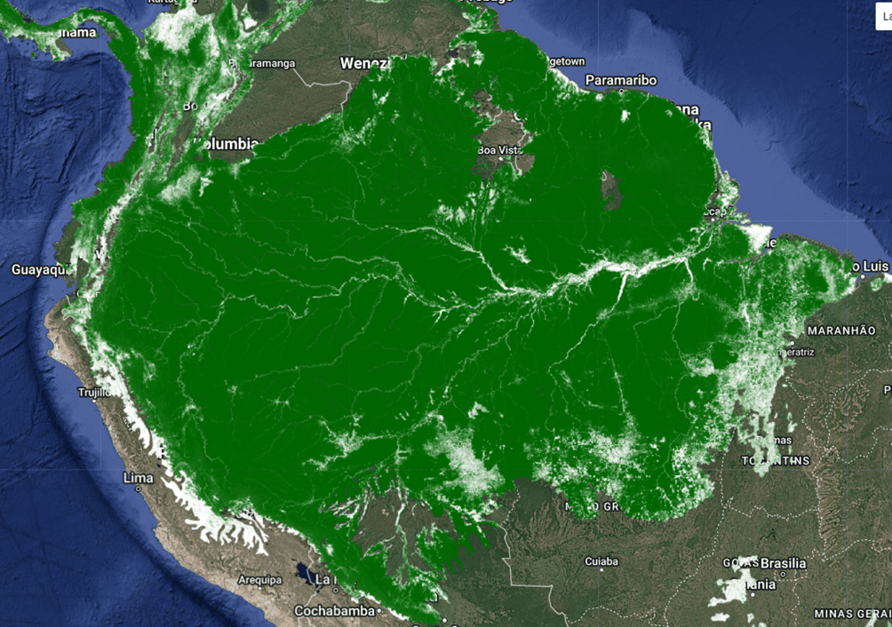
Amazonia is the world's largest rainforest, covering some 5.5 million square kilometers and stretching across nine South American countries - more than 60% of which are in Brazilian territory. It is the so-called “green lung of the Earth,” responsible for storing huge amounts of carbon dioxide and maintaining global water cycles. Based on satellite images from 2000, a set of WWF Ecoregions 2017 (RESOLVE) was created, and forest cover was visualized using data from Hansen Global Forest Change.
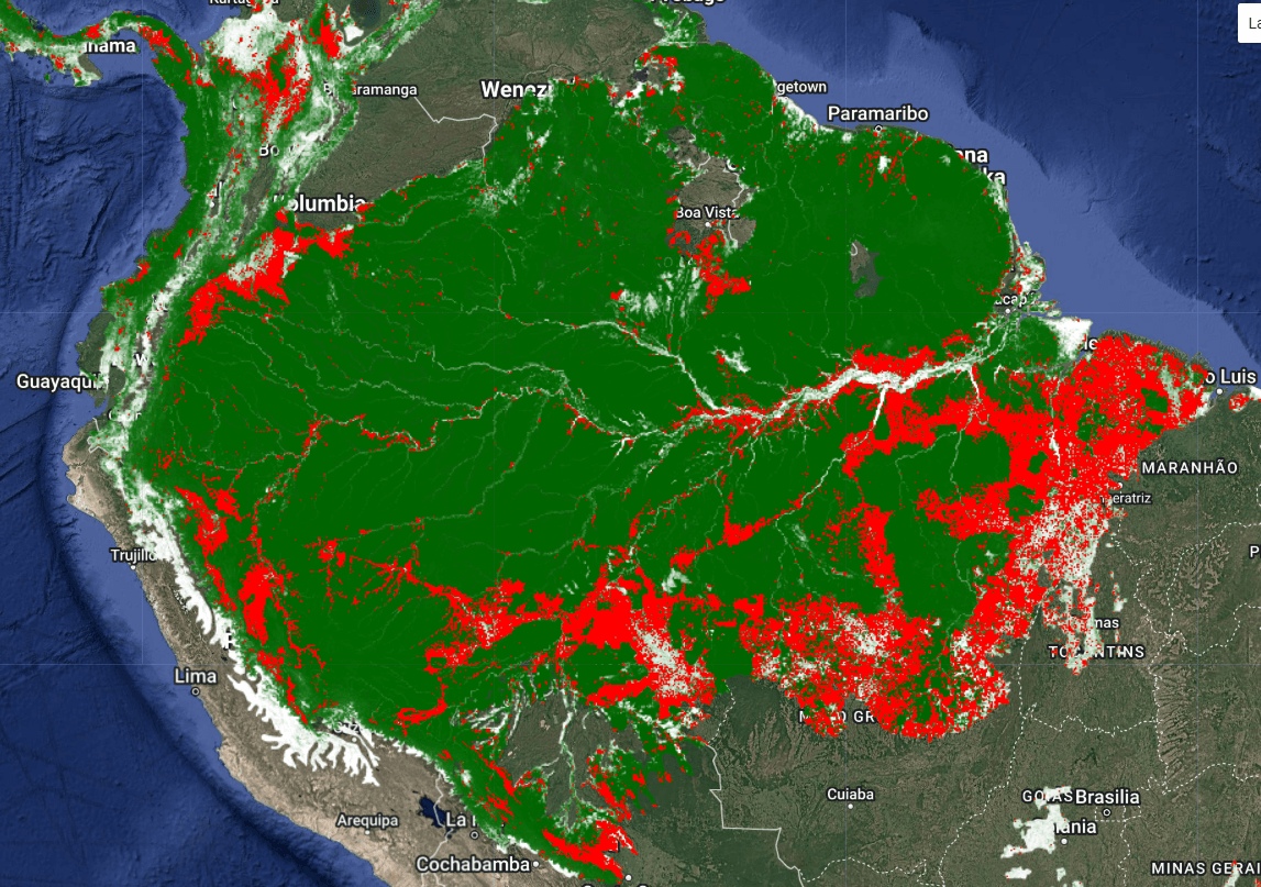
According to the Instituto Nacional de Pesquisas Espaciais, the Brazilian portion of the Amazon forest has lost more than 430,000 km² of forest cover since 2000 - more than the area of Germany. The entire Amazon region (all countries combined) has lost up to 850,000 km², or about 17% of its total forest cover, since the beginning of the century.
The image below shows the areas of forest (in green) and where degradation has occurred from 2001 to 2022 (in red). The data, as before, comes from the Hansen Global Forest Change set, which records changes in forest cover each year based on Landsat satellite data.
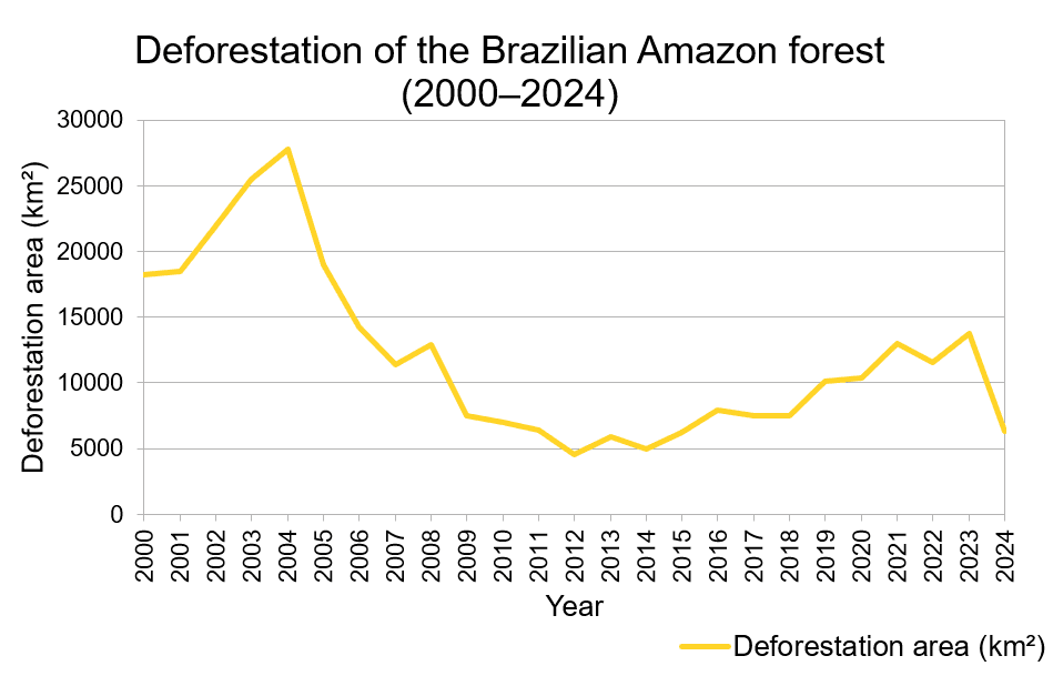
Deforestation trends have their deviations from the norm, but the overall trend remains alarming. The highest level of forest degradation, was recorded in 2004, when as much as 27,772 km² were cleared in just one year. Although subsequent years have brought improvements, we still see a lack of cessation of logging.
Examples of rainforest deforestation
Analyzing satellite images taken by the Landsat 5 satellite in 2001 and images from the Landstat 8 satellite in 2024 for selected regions of the Amazon, including the Brazilian state of Rondônia, specifically the area around Porto Velho, as well as the Mato Grosso area, which is one of Brazil's main agricultural areas, a dramatic decline in forest cover has been identified.
Based on data from Global Forest Watch, it is fair to say that Porto Velho, the capital of Rondônia state, is one of the most deforested places in the Amazon region. Between 2001 and 2024, the municipality lost some 1,09 million hectares of forest cover - a significant portion of the total forest loss in the state of Rondônia.
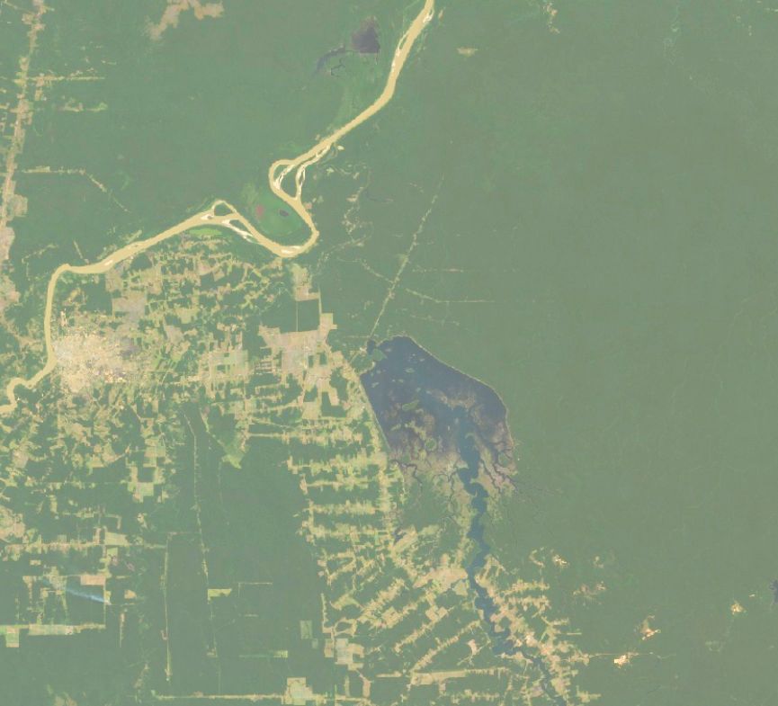
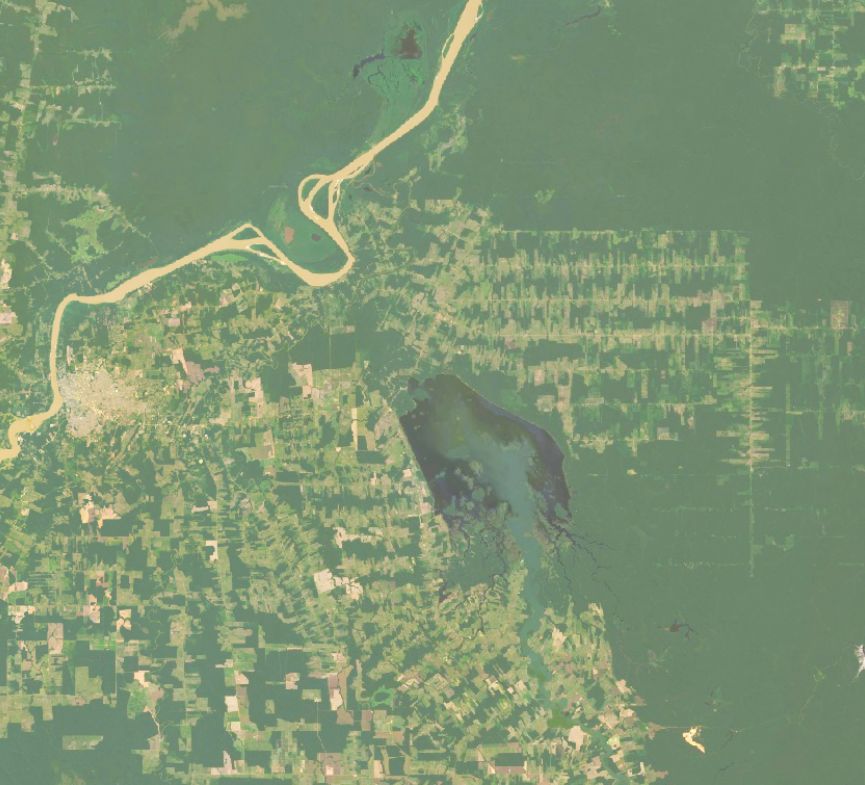
Satellite comparison of forest cover - a slice of the state of Rondônia from 2001 to 2024.
The Mato Grosso area, between 2001 and 2024, lost about 14,2 million hectares of forest, a 25% decrease compared to the state in 2000. This environmental degradation contributed about 6,48 gigatons of CO₂ equivalent emissions.
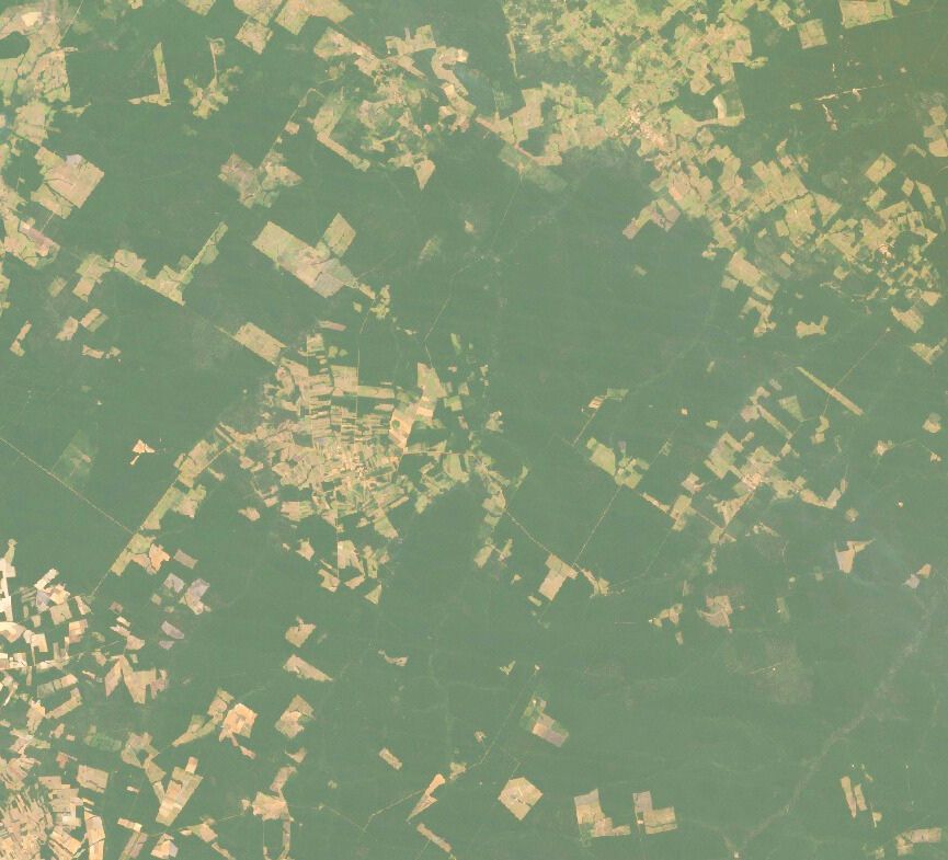
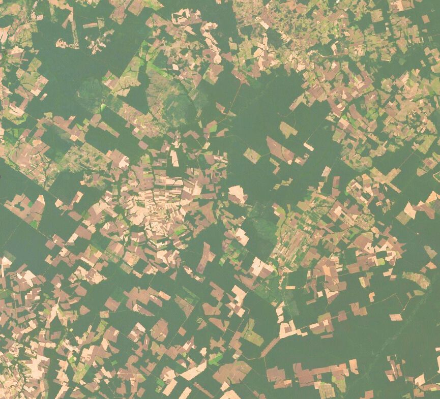
Satellite comparison of forest cover -fragment of Mato Grosso region from 2001-2024
What is accelerating deforestation in the Amazon?
Analyses of the Amazon forest area have distinguished the main factors responsible for forest degradation:
- Expansion of commodity agriculture - mainly soybeans and cattle.
- Illegal logging - often masked as “development.”
- Mining and extractive industries - exploration of deposits opens up new areas.
- Infrastructure - new roads, transmission lines and development.
Deforestation of the Amazon forest is not just an environmental problem - it is a picture of a global economic system that treats nature as a resource to be consumed quickly.
Green Deal vs. green hypocrisy?
In Europe, the Green Deal is being introduced, whose demands ban the production of plastics, enforce reductions in gas emissions and promote sustainable development. At the same time, tropical forests are being cut down on a massive scale in South America. Do local efforts make sense without global coordination?
The article does not question the legitimacy of the European Union's actions, but it does point out a paradox: is climate policy really effective action, or rather political branding? Satellite data show unequivocally - nature does not recognize national borders or social beliefs.
In our world, single actions are not enough. CO₂ emissions, deforestation, climate change are problems that do not span national borders and are visible everywhere. Satellite images are proof that environmental action is not enough. We need global, thoughtful and realistic decisions.
Satellites don't lie, satellites illustrate
Our technologies, satellite data, image analysis algorithms, and geospatial tools offer hard evidence of irreversible changes in the ecological environment. At OnGeo Intelligence, we believe that the future of environmental policy must be based not on declarations, but on data. And these clearly show that it is time to act together, across national borders.
The Bolivian Amazon is disappearing — and satellite imagery proves it
A powerful visual testimony to this crisis is presented in the stellite imagery. Reveals how vast areas of forest have been lost over the years, as satellite data captures the stark contrast between once-dense jungles and now-barren landscapes. The consequences go far beyond environmental degradation—they directly impact indigenous communities, wildlife, and the planet’s ability to regulate carbon. This film underscores a sobering truth: protecting the Amazon is not just about saving trees, but preserving life on Earth. 🌎
See what the satellite sees
If you want to learn more about how technology can reveal environmental changes, check out our Satellite Imagery Report. The data we provide can support:
- investment planning,
- environmental protection,
- administrative proceedings,
- as well as your personal knowledge of a world that is changing.
🛰️ OnGeo Intelligence - we see what others don't notice.
From space. With precision. With the planet in mind.
Related articles
- How to Find & Order Satellite Images with Ongeo Intelligence?
- A List of Earth Observation Satellites & Optical Parameters
- A Guide to Maxar’s Persistent Change Monitoring (PCM)
- Why Accuracy Matters in High-Resolution Satellite Imagery
- The Atlantic Forest Deforestation: South America's Silent Drama Seen from Space
- Satellite Forest Monitoring from Space: Global Tree Mapping with Satellite Earth Observation