Satellite Imagery Pricing: A Comprehensive Guide to Costs and Value
Determining the cost of satellite imagery is a crucial step in planning for projects across industries, from agriculture and urban planning to environmental monitoring and market intelligence. Unlike standardized products, the price of a satellite image is not a fixed figure. Instead, it is a variable cost calculated based on a range of technical specifications and acquisition parameters.
This guide provides a detailed analysis of satellite imagery pricing, breaking down the primary cost drivers and examining the offerings of key commercial providers. It also contrasts these commercial options with high-value, free satellite imagery sources to provide a complete market overview.
Key Factors That Determine Satellite Imagery Pricing
Several core variables directly influence the final cost of satellite imagery. A clear understanding of these factors is essential for accurately budgeting and procuring the right data for a given application.
1. Spatial Resolution: The Primary Cost Driver
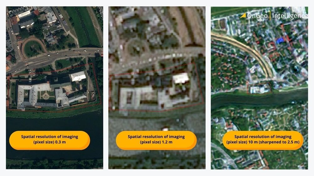
Spatial resolution defines the level of detail in an image and is the most significant factor impacting satellite imagery pricing. A higher resolution means more detail but also a significantly higher cost.
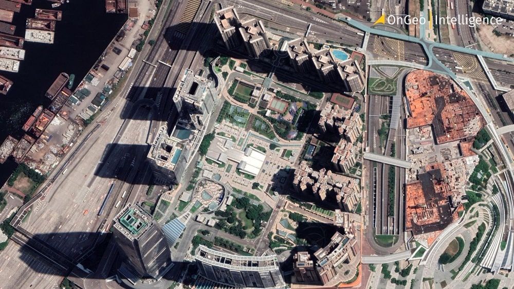
- Very High Resolution (VHR - 0.3m to 2m): While more expensive, VHR imagery is essential for identifying specific details. At this level, it is possible to see individual objects like buildings, vehicles, road infrastructure, construction progress, or precise property boundaries. For the highest precision, resolutions of 0.5m or 0.3m are recommended. This level of detail is critical for verification, site monitoring, and detailed asset management.
- Medium-to-Low Resolution (e.g., 10m Sentinel-2): This resolution is excellent for analyzing large areas and observing widespread phenomena. It is perfectly suited for monitoring large agricultural fields, forests, or general land cover changes over a region. However, it is not possible to see details like individual cars or small buildings at this resolution.
2. Data Vintage: Archive vs. New Tasking
The age and acquisition method of an image create a major price differential.
- Archive Imagery: These are existing images stored in a provider’s digital library. Because the cost of satellite operation has already been absorbed, archive data is the most cost-effective option.
- New Tasking: This involves commissioning a satellite operator to capture a new image over a specific Area of Interest (AOI). This service is priced at a premium as it requires allocating satellite resources for a specific collection.
3. Area of Interest (AOI) and the Minimum Order Quantity (MOQ) Challenge
A significant barrier in direct procurement is the Minimum Order Quantity (MOQ) enforced by most global providers. This is the smallest area a client can purchase, often set at 25 km² for archive imagery and 100 km² or more for new tasking.
This policy makes acquiring data for a small area - such as a single construction site, property, or farm - prohibitively expensive, as the user must pay for a large scene they do not need.
Overcoming Market Barriers with Specialized Services
The challenge of large MOQs and the technical complexity of data processing have created a need for services that bridge the gap between global operators and end-users. These services make professional satellite data accessible and affordable for projects of any scale.
A key example of this innovative approach is the Satellite Imagery Report from Ongeo Intelligence. What sets this service apart is not just the ability to purchase data on a micro-scale, but also an incredibly simple and transparent pricing process.
The Ongeo Intelligence Process for Satellite Imagery Pricing
A user can instantly check the cost of an image in a few intuitive steps. Without needing to log in, you can simply visit the site, draw your area of interest on the map, and define a time period. The system automatically searches available archives and presents the results as image thumbnails, complete with key information: acquisition date, resolution, and the price.
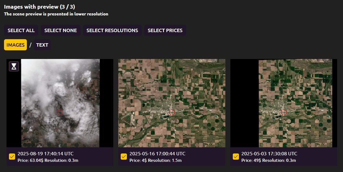
This solution is exceptionally convenient and allows for immediate pricing without complex quote requests to operators like Maxar, Airbus or Planet.
A unique feature of this service is its ability to provide high-resolution imagery on a micro-scale. This completely eliminates the MOQ barrier, allowing users to order a report for a small, specific area without having to purchase a vast 25 km² or 100 km² scene.
This model provides several distinct advantages
- Affordability: Users pay only for the small area they need, making VHR data accessible for tasks like verifying property lines or monitoring a single building.
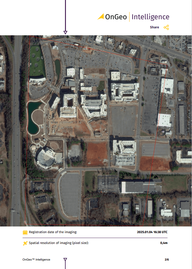
- Simplicity: It removes the technical burden of processing large, complex datasets. Instead of raw data files requiring advanced GIS software, the user receives a user-friendly, analysis-ready report.
- Speed and Convenience: The entire process is streamlined. Users bypass the lengthy quoting and procurement procedures with global operators and can receive their high-resolution report quickly, accessible even on a mobile device.
Furthermore, platforms like Ongeo Intelligence often integrate different data types, offering 10m resolution imagery completely free with a discount code, which is ideal for preliminary analysis before investing in VHR data.
Commercial Satellite Imagery Prices: A Market Analysis
For users who do need to purchase large areas directly, analysis of the market and industry reports like the pricing guide from Geoawesome helps establish reliable price ranges.
Very High Resolution (VHR) Providers: Maxar and Airbus
Maxar Technologies (WorldView) and Airbus Defence and Space (Pléiades) are leaders in the VHR market.
- VHR Archive Imagery (<1m): Pricing generally falls within the $15 to $30 per km² range.
- VHR New Tasking (<1m): Standard tasking orders typically start from $40 to $60 per km², rising for priority requests.
Satellite Imagery Pricing Summary Table
| Resolution Category | Data Type | Typical Price Range (per km²) | Common MOQ |
| VHR (<1m) | Archive | $15 - $30 | 25 km² |
| VHR (<1m) | New Tasking | $40 - $100+ | 100 km² |
Free Satellite Imagery: High-Value Open-Source Alternatives
For many large-scale applications, commercial satellite imagery is not necessary. As detailed in this guide to free satellite imagery sources, government-funded programs provide immense value.
- Copernicus Programme (Sentinel-2): Offers 10m resolution data with a high revisit rate, perfect for monitoring agriculture and land use change.
- Landsat Program (NASA/USGS): Provides 30m resolution data essential for long-term environmental analysis.
Conclusion: A Strategic Approach to Acquiring Satellite Imagery
The cost of satellite imagery is directly tied to its technical specifications. While direct procurement of VHR data involves high costs and large minimum areas, the market has evolved. Specialized services like OnGeo Intelligence now offer a transformative solution by enabling the purchase of micro-scale, high-resolution imagery in a simple, affordable, and ready-to-use format. By matching the right data source - be it a specialized report, a direct VHR purchase, or free open-source data - to the specific needs of a project, users can maximize value and achieve their goals efficiently.