From space tech to your smartphone: the rise of satellite photos for everyone
From the perspective of a satellite technology expert, we are currently witnessing one of the most fascinating trends in the history of the geospatial industry: a quiet revolution in data access. What was for decades the domain of governments, the military, and scientific corporations is now becoming a publicly accessible tool. We are talking about the fundamental democratization of satellite imagery, a phenomenon driven not only by technological progress but by the growing awareness and specific needs of millions of people worldwide. This is the story of how satellite photos for everyone became a reality, from NASA Earth Observatory initiatives to commercial satellite imagery providers.
A market driven by new demand: the numbers don't lie
To understand the scale of the ongoing shift in satellite data usage, it helps to examine growth trends across the satellite industry as a whole. Both the satellite communications sector and the Earth Observation market are experiencing rapid expansion, fueled not only by traditional big players but increasingly by individual users and smaller organizations. Below, two key perspectives illustrate this evolution.
Growth in satellite communications and imagery markets
According to a recent report by MarketsandMarkets, the satellite communication sector alone was valued at approximately USD 14.9 billion in 2023 and is projected to more than double to USD 33.2 billion by 2029. This boom reflects not just advancements in technology but also increasing global reliance on satellite-based services.
Similarly, the Earth Observation (EO) satellite imagery market is forecasted for robust growth. While defense, agriculture, and environmental monitoring remain major drivers, an emerging and vital force behind this surge is the expanding demand from “long tail” users — individuals, small businesses, lawyers, property managers, and citizen scientists. This broadening user base fuels the push for accessible satellite imagery and analytics, transforming EO data into a tool for everyone.
The democratization of satellite data access: insights from copernicus CDSE
This democratization is vividly illustrated by the Copernicus Data Space Ecosystem (CDSE), as highlighted in the Copernicus Data Space Ecosystem Annual Report 2023 - an open European platform providing free and easy access to satellite imagery from the Sentinel constellation.
Did you know?
In 2023 alone, CDSE saw its active user base soar past 85,000 registered individuals, with numbers surpassing 140,000 by early 2024.
Notably, a significant share of these users are private citizens and small organizations leveraging satellite data for everyday, non-commercial purposes.
Advanced tools such as Sentinel Hub and openEO empower even non-expert users to effortlessly browse, analyze, and download satellite images - often available within just a few hours after capture.
Did you know?
In 2023, Sentinel Hub processed over 150 million user requests, covering imagery equivalent to 80 times the Earth’s landmass.
The practical impact is clear: satellite imagery is no longer confined to governments or large corporations. Increasingly, ordinary people use it to gather evidence for legal disputes, support insurance claims, monitor environmental changes, and oversee local developments - marking a paradigm shift in how Earth Observation data is consumed and valued.
More than a fence dispute: the broadening spectrum of everyday use
Initially, consumer-level applications were limited to simple property line disputes. Today, we are seeing a much broader and more creative use of satellite data, illustrated by real-life stories that showcase the power of historical satellite imagery and real-time satellite imagery.
Preventive real estate analysis
Imagine a family who found their dream plot of land in a picturesque area. Before signing the contract, they ordered a historical satellite report. The analysis of photos from the last five years revealed that during the spring thaws, the access road turned into a quagmire, and a nearby stream regularly overflowed, flooding part of the property. This knowledge, gained from satellite photos for everyone, allowed them to avoid a costly mistake.
Fighting environmental damage
Residents of a small town had long suspected that a local industrial plant was illegally discharging wastewater into the river. A group of residents ordered a series of satellite images. Analysis in the infrared spectrum (NIR channels) clearly showed a plume of pollution and the progressive die-off of vegetation along the bank. The report, bearing specific dates, became overwhelming evidence and forced the institutions to intervene.
Verifying extreme weather damage
A homeowner insured his house, including newly installed solar panels. Two months later, a massive hailstorm damaged the installation. The insurer tried to argue that the damage might have pre-existed. The owner presented a high-resolution satellite photo taken just a week before the storm, showing the pristine panels. This ended the discussion and expedited the insurance payout.
It is precisely such practical applications that are making satellite photos for everyone more than just a novelty; they are becoming a useful tool, with both free satellite imagery and commercial options available.
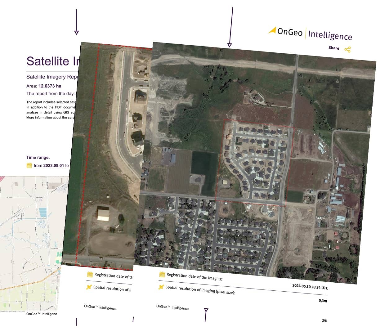
Satellite Imagery Report by OnGeo Intelligence
In response to growing demand, solutions are emerging that make satellite photos accessible for everyone. An example is the Satellite Imagery Report from OnGeo Intelligence.
This platform was created with the average user in mind.
A customer points to an area on a map, selects a date range, and receives a clear PDF report, ready to be opened on any device. It is services like these that are driving the revolution in the accessibility of space data.
Satellite photos vs. other methods – what makes them stand out?
The popularity of data from orbit stems from its unique features compared to traditional methods. This includes the ability to access free satellite maps and download satellite imagery for various purposes.
- Credibility: Unlike a phone photo, a satellite image has a hard, unalterable timestamp, which makes it incredibly reliable.
- Objectivity: A satellite is an impartial observer. It has no stake in the matter; it simply records facts, giving it an edge over subjective witness testimonies.
- Access to the past: This is its greatest strength! The ability to go back in time and check the history of a site is a feature no other popular tool offers, making historical satellite imagery invaluable.
A realistic perspective: the strengths and limitations of an eye in the sky
As an expert, I must emphasize that satellite imagery, despite its power, is not a universal solution. Its effective use depends on understanding both its strengths and its limitations, whether you're using free satellite data or paid services.
The pros and cons – the whole truth about satellite images
Advantages:
✅ Objectivity and credibility: Data from orbit is taken very seriously by institutions.
✅ Archival access: The ability to perform historical analysis is a key advantage.
✅ Cost-effectiveness: It is often a cheaper solution than hiring experts, especially with free satellite imagery options available.
Disadvantages:
❌ Resolution: Satellite images won't show a crack in a window but are perfect for revealing larger-scale changes (buildings, forests).
❌ Weather: Thick clouds on a crucial day can render an image useless.
❌ Frequency: Satellites don’t photograph every square meter of Earth daily, which can lead to gaps in the archive.
The voice from the market: an evolution in customer needs
This trend is clearly visible in the data from companies offering access to imagery. As Geospatial Product Engineer at OnGeo Intelligence notes:
Geospatial Product Engineer at OnGeo Intelligence
We are observing a fascinating evolution. Few years ago, an individual client would order a report mainly out of curiosity. Today, 8 out of 10 such inquiries have a specific business or legal purpose. Clients come with a ready problem: a court dispute, an insurance claim, an investment verification. They are no longer just buying a picture. They are buying a date, a piece of evidence, an objective record of fact. This clear shift from 'nice-to-have' to 'must-have' is the most important trend shaping the consumer geospatial services market today, making satellite photos for everyone a tangible reality.
A barrier to entry? Not anymore.
This growing wave of demand could have crashed against a wall of technical complexity if not for platforms like OnGeo Intelligence. They play a key role in this revolution by abstracting away complicated data formats (like GeoTIFF) and analysis. By providing the client with a ready-made, readable PDF report, they make advanced technology as easy to use as a banking app. These satellite imagery platforms are making remote sensing data more accessible than ever before.
The democratization of satellite data is a process that has already happened. We are now entering an era of its widespread, conscious use. It is no longer a question of "if," but "how" this technology will change further aspects of our daily lives, cementing the age of satellite photos for everyone. From open data sources to commercial satellite imagery, the future of Earth observation is bright and accessible.
Related articles
- Aerial photos as evidence in the case
- How to Download Free Sentinel Data: A Step-by-Step Guide
- How to Acquire Free Satellite Imagery for Your Investigations
- How Free Satellite Imagery Can Help Farmers Optimize Crop Management
- Free Maxar Imagery: Take Part in the OnGeo Promotion and Get Very High Resolution Satellite Images for Free