Vantor/Maxar vs Planet Labs: High-Resolution Imagery Comparison
In the modern geospatial stack, satellite imagery is no longer just a visualization layer it is becoming a core data primitive. From AI-driven analytics to real-time monitoring systems, the quality and cadence of imagery now directly shape what can be built.
Two companies sit at the center of this shift: Maxar Technologies and Planet Labs.
At first glance, they appear to offer the same thing images of the Earth from space. But under the hood, they represent two fundamentally different approaches to observing the planet. Maxar pushes the limits of spatial resolution, capturing highly detailed snapshots of specific locations. Planet Labs takes the opposite route, scanning the entire Earth daily to build a continuously updating record of change.
The Core Difference: Precision vs Persistence
At the heart of the comparison between Maxar Technologies and Planet Labs is a fundamental design choice: precision versus persistence.
Maxar is built around precision. Its satellite systems are optimized to capture extremely high-resolution imagery of targeted locations. The goal is clarity seeing the finest possible details on the Earth’s surface at a given moment. This makes Maxar’s data particularly valuable when the question is “what exactly is happening here?”
Planet Labs, by contrast, is built around persistence. Its constellation is designed to image the Earth continuously, capturing the same locations again and again with high frequency. The emphasis is not on extreme detail, but on temporal depth creating a living, breathing record of change over time. Here, the dominant question becomes “how is this changing?”
This distinction shapes everything:
- Data architecture (tasked vs continuous capture)
- Analytical workflows (inspection vs monitoring)
- Product design (precision APIs vs time-series datasets)
In practical terms:
- Maxar gives you clarity in space
- Planet gives you continuity in time
Neither approach is inherently superior they are optimized for different layers of understanding. And increasingly, the most powerful geospatial systems are those that recognize this and build around both.
Image Resolution: The Detail Gap
When it comes to raw image clarity, the gap between Maxar Technologies and Planet Labs is significant and it defines how their data can be used.
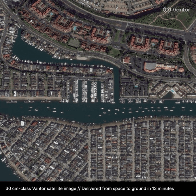
Maxar operates at the high end of commercial satellite imaging, with resolutions reaching ~30 cm per pixel. At this level, imagery moves beyond general observation into object-level intelligence. You can distinguish individual vehicles, building structures, road markings, and fine infrastructure details. This is the kind of resolution required for precision mapping, defense analysis, and detailed urban modeling.
Planet Labs, in contrast, typically provides imagery in the ~3–5 meter resolution range through its SuperDove satellites. While this may seem coarse by comparison, it serves a different purpose. At this scale, the focus shifts from individual objects to broader spatial patterns crop health, deforestation, flood extent, urban expansion, and land-use change.
The difference is not just technical it’s functional:
- Maxar enables you to zoom in and inspect
- Planet Labs enables you to zoom out and understand patterns
This creates a clear boundary in application design:
- If your use case depends on identifying specific objects or fine-grained features, high-resolution imagery is non-negotiable.
- If your focus is on trends, anomalies, or large-scale changes, slightly lower resolution is often sufficient and far more scalable.
In reality, this “detail gap” is less of a limitation and more of a specialization. Each resolution tier unlocks a different layer of insight, and knowing which layer you need is what separates a working geospatial product from an over-engineered one.
Revisit Frequency: The Time Advantage
If resolution defines how clearly you see the world, revisit frequency defines how often you see it and this is where Planet Labs establishes a decisive edge over Maxar Technologies.
Planet Labs operates one of the largest constellations of Earth observation satellites, enabling it to image nearly the entire Earth’s landmass every day. This creates a continuously updating visual record effectively a time-series dataset of the planet.
Vantor Satellite Constellation: The World’s Most Advanced High-Resolution Imaging Network
Vantor/Maxar, by contrast, relies on a more selective imaging model. Its satellites are often tasked to capture specific locations, meaning revisit times depend on priority, scheduling, and orbital constraints. While Maxar can revisit areas relatively quickly when needed, it does not provide the same level of continuous, global coverage.
This difference fundamentally changes how data is used.
With Planet, the question becomes:
“What changed between yesterday and today?”
With Maxar, the question is more often:
“What does this location look like right now, in the highest possible detail?”
The advantage of high revisit frequency becomes especially clear in dynamic scenarios:
- Agriculture → tracking crop health over time
- Disaster response → monitoring floods, fires, or storm impact
- Environmental change → deforestation, water levels, land degradation
- Supply chains → activity patterns at ports, mines, or infrastructure sites
In these contexts, temporal resolution can be more valuable than spatial resolution. A slightly lower-quality image captured every day is often more actionable than a perfect image captured once.
This is the core of Planet’s time advantage:
it transforms satellite imagery from a static asset into a continuous signal.
And for modern AI systems and geospatial applications, signals especially consistent, high-frequency ones are where real intelligence begins to emerge.
Coverage vs Tasking
Beyond resolution and revisit frequency, another critical distinction between Maxar Technologies and Planet Labs lies in how the data is actually collected: coverage vs tasking.
Maxar operates primarily on a tasking model. This means imagery is captured based on specific requests you define a location, time window, and priority, and the satellite is directed to acquire that scene. The result is highly intentional data collection, optimized for precision use cases.
Planet Labs takes a fundamentally different approach. Its satellites follow a continuous coverage model, scanning large portions of the Earth systematically without needing individual requests. The data already exists by the time you need it, forming a vast archive of regularly updated imagery.
Analysis-Ready PlanetScope (ARPS)
Accelerate your analytical workflows with pre-processed, harmonized satellite imagery.
This difference has deep implications for how systems are built:
- Maxar (Tasking Model)
On-demand, location-specific capture
Higher cost per scene
Best for targeted analysis and validation
Workflow resembles a query → capture → analyze pipeline
Planet Labs (Coverage Model)
Always-on, global data collection
Immediate access to historical imagery
Best for monitoring and time-series analysis
Workflow resembles a stream → filter → analyze pipeline
From a developer’s perspective, this is not just about data it’s about latency and availability.
With Maxar, there is a delay between identifying a need and acquiring the data.
With Planet, the data is already there, enabling near real-time analysis.
This makes Planet particularly powerful for building automated systems, where pipelines depend on consistent data ingestion. Meanwhile, Maxar fits naturally into workflows that require high-confidence verification at critical moments.
In essence:
- Tasking is intentional and precise
- Coverage is continuous and scalable
Understanding this distinction is key when designing geospatial APIs, analytics pipelines, or AI models because it determines whether your system reacts to the world, or continuously watches it.
Cost and Accessibility
Cost and accessibility are where the differences between Maxar Technologies and Planet Labs become especially practicalshaping who can build, experiment, and scale with their data.
Maxar’s model, centered around high-resolution and tasked imagery, naturally comes at a premium. You are paying not just for data, but for precision, control, and exclusivity. This makes it a strong fit for governments, enterprise clients, and high-stakes use cases where detail is critical and budgets are less constrained.
Planet Labs, on the other hand, is designed for scale and accessibility. Its continuous imaging approach allows it to distribute costs across a much broader dataset, making its imagery more approachable for startups, researchers, and developers. Combined with easier access to historical data, this lowers the barrier to entry significantly.
But the real difference isn’t just price it’s how each platform fits into a workflow:
- Maxar
- Higher cost per request
- More friction in acquisition (tasking, approvals, prioritization)
- Best suited for targeted, high-value insights
- Planet Labs
- More predictable, scalable pricing
- Immediate access to large volumes of data
- Best suited for continuous analysis and experimentation
For builders especially those developing APIs, AI models, or geospatial products this distinction matters. Lower-cost, readily available data enables iteration, which is essential in early-stage development.
In many cases, Planet becomes the default data layer for building, while Maxar is introduced later as a premium layer for validation or high-resolution insights.
Where OnGeo Fits: The Intelligence Layer Above Imagery
Comparing Maxar and Planet highlights a key distinction in the geospatial market: both companies are fundamentally imagery providers. Maxar competes on ultra-high-resolution data, while Planet focuses on frequent global coverage. In both cases, the product is still raw or lightly processed imagery.
OnGeo Intelligence operates at a different layer of the stack. Rather than competing in data capture, it sits above imagery providers and turns satellite data into usable intelligence. Its value is not in offering better imagery, but in abstracting provider complexity, combining multiple data sources, and delivering signals that developers and businesses can act on directly.
This is the core difference: Maxar and Planet provide pixels. OnGeo Intelligence provides outcomes. Instead of requesting satellite imagery for a location, users can ask to detect change, monitor activity, or flag anomalies. That shift from raw data access to actionable intelligence is where OnGeo Intelligence creates value.
Learn more about: Satellite Imagery Report
Conclusion: Maxar vs Planet Labs Which Satellite Imagery Provider Is Right for Your Project?
| Feature | Maxar | Planet Labs |
|---|---|---|
| Resolution | ⭐⭐⭐⭐⭐ (~30 cm) | ⭐⭐⭐ (~3–5 m) |
| Daily Coverage | Limited | Global Daily |
| Historical Archive | Moderate | Extensive |
| Best For | Inspection, Mapping, Defense | Monitoring, Agriculture, Environment |
| Tasking | Yes | Mostly No |
| Time-Series Analysis | Limited | Excellent |
| Cost | Higher | More Scalable |
Choosing between Maxar and Planet Labs depends on your specific use case. Maxar delivers ultra-high-resolution imagery for detailed analysis, while Planet Labs excels at daily global monitoring and time-series insights. In many geospatial applications, the best results come from combining both approaches using Planet to detect changes and Maxar to investigate them in detail. As the industry evolves, the greatest value increasingly comes from platforms that transform satellite imagery into actionable intelligence rather than simply providing raw data.