Satellite Imagery for Disaster Response and Recovery
Natural disasters such as floods, earthquakes, wildfires, and hurricanes can affect large areas within a short period of time, making rapid assessment difficult using ground-based methods alone. In the immediate aftermath of a disaster, decision-makers need accurate information to understand the extent of damage and prioritize response efforts.
Satellite imagery provides a reliable way to observe affected regions from space, offering wide-area coverage and consistent data even when access on the ground is limited. By capturing conditions before and after an event, satellite data supports damage assessment, emergency response planning, and long-term recovery monitoring.
This article explains how satellite imagery is used in disaster response and recovery, and why Earth observation has become an essential component of modern disaster management.
How Satellite Imagery Supports Disaster Response
Satellite imagery plays a critical role in disaster response by providing rapid, large-scale visibility of affected areas. When ground access is limited or unsafe, satellite data offers an immediate overview that helps responders understand the situation and act quickly.
One of the main advantages of satellite imagery is its ability to cover vast regions in a single observation. This allows emergency teams to assess the extent of a disaster, identify heavily impacted zones, and prioritize areas that require urgent assistance.
Satellite data supports disaster response by enabling:
- Rapid assessment of affected areas
- Identification of damaged infrastructure and blocked access routes
- Monitoring of ongoing hazards such as flooding or wildfires
- Support for coordination between response agencies
Different types of satellites contribute depending on conditions. Optical imagery provides detailed visual information in clear weather, while radar satellites can capture data through clouds, smoke, and darkness making them especially valuable during active disaster events.
By delivering timely and objective information, satellite imagery helps improve situational awareness and supports more effective disaster response efforts.
Rapid Damage Assessment After Disasters
Rapid damage assessment is one of the most important applications of satellite imagery following a disaster. In the hours and days after an event, responders need to understand the scale and severity of damage in order to allocate resources effectively.
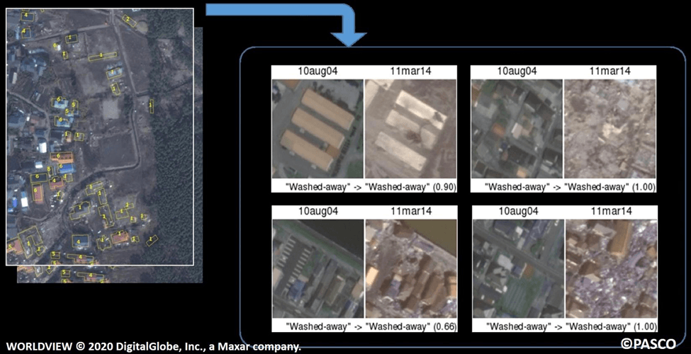
Satellite imagery enables analysts to quickly evaluate affected areas by comparing recent images with pre-disaster conditions. This allows for the identification of flooded zones, burned areas, collapsed structures, and damaged infrastructure without requiring immediate ground access.
Common rapid damage assessment use cases include:
- Mapping flood extent and water depth
- Identifying burned areas after wildfires
- Detecting structural damage to buildings and roads
- Assessing landslides and debris flows
Radar satellite data is particularly valuable during this phase, as it can capture images regardless of cloud cover, smoke, or low light conditions. This ensures that damage assessment can continue even when weather or environmental factors limit visibility.
By providing timely and objective damage insights, satellite imagery supports faster decision-making and more targeted disaster response efforts.
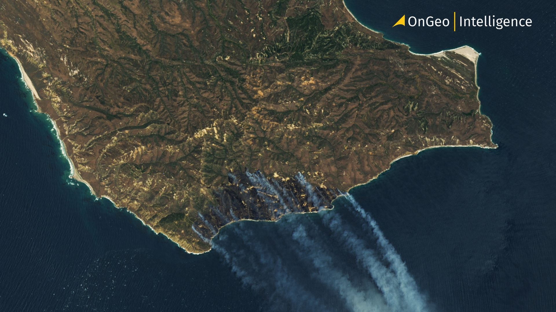
Santa Rosa Island Wildfire - Satellite Imagery, May 2026
Before-and-After Imagery for Impact Analysis
Before-and-after satellite imagery is a powerful tool for understanding the full impact of a disaster. By comparing images captured prior to an event with those taken afterward, analysts can clearly identify what has changed and quantify the extent of damage.
This comparative approach helps isolate disaster-related impacts from pre-existing conditions. It allows responders and decision-makers to distinguish between newly affected areas and long-standing infrastructure or environmental features.
Before-and-after imagery is commonly used to:
- Measure the spatial extent of damage
- Identify affected buildings, roads, and critical infrastructure
- Support prioritization of response and recovery efforts
- Provide visual evidence for reporting, insurance, and aid coordination
Time-series comparisons also reveal how conditions evolve in the days and weeks following a disaster, helping track ongoing risks such as secondary flooding, erosion, or fire spread.
By providing clear, time-stamped visual evidence, before-and-after satellite imagery supports more accurate impact analysis and improves transparency throughout disaster response and recovery processes.
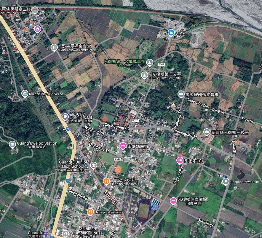
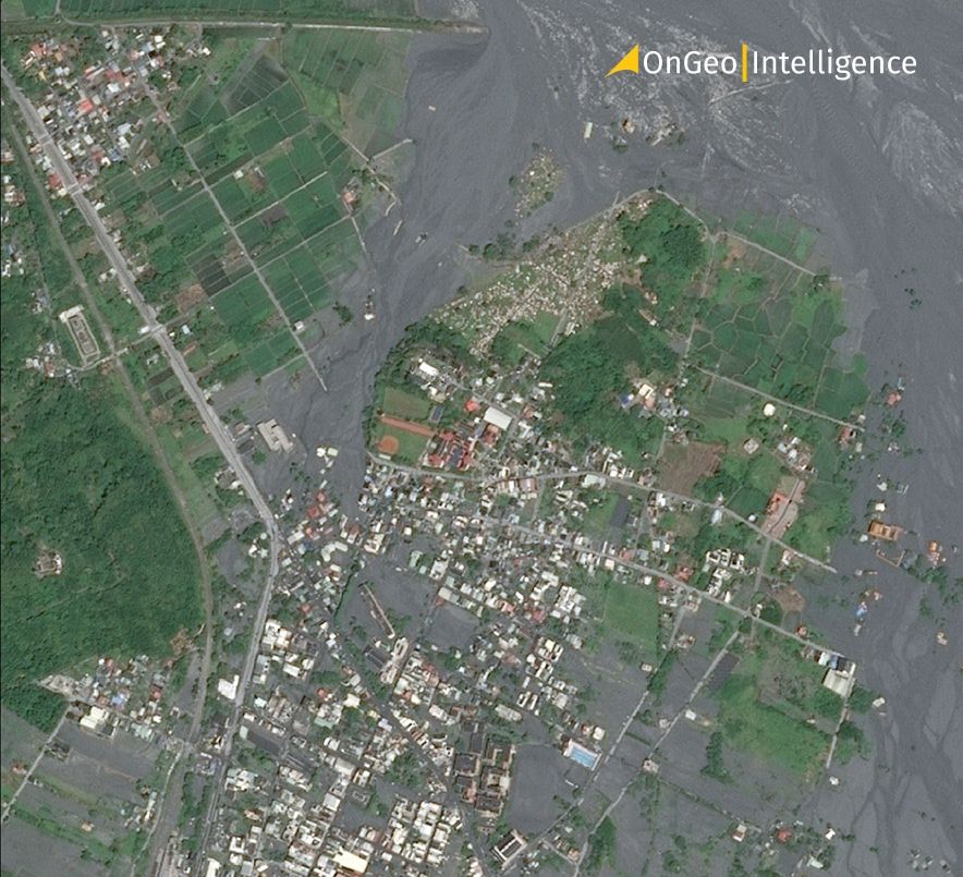
Super Typhoon Ragasa, Guangfu - before and after
Supporting Recovery and Reconstruction
Satellite imagery continues to play an important role beyond the immediate response phase, supporting recovery and reconstruction efforts in the weeks, months, and even years following a disaster.
During recovery, satellite data helps monitor rebuilding progress and identify areas where reconstruction may be delayed or uneven. By observing changes over time, stakeholders can assess whether infrastructure, housing, and essential services are being restored as planned.
Satellite imagery supports recovery and reconstruction by enabling:
- Monitoring of rebuilding and infrastructure repair
- Detection of temporary settlements or land-use changes
- Tracking environmental recovery or degradation
- Supporting accountability and progress reporting
Long-term satellite monitoring also helps identify recurring risks, such as repeated flooding or erosion, which can inform more resilient reconstruction planning.
By providing a consistent, objective view of recovery efforts, satellite imagery supports better coordination, transparency, and long-term resilience in post-disaster environments.
How OnGeo Intelligence Supports Disaster Response Workflows
Applying satellite imagery during disaster response often requires fast access to reliable data and the ability to compare conditions over time. OnGeo Intelligence helps streamline this process by making satellite imagery easier to obtain and analyze for specific locations.
Through OnGeo Intelligence, users can generate location-based satellite reports that support disaster response and recovery workflows. These reports provide access to recent and historical imagery, enabling quick before-and-after comparisons without the need for complex geospatial processing.
These capabilities are particularly useful for teams that need actionable insights quickly, such as emergency responders, planners, insurers, and humanitarian organizations.
By simplifying access to satellite data, OnGeo Intelligence helps integrate Earth observation into disaster response efforts more efficiently.
ORDER A SATELLITE IMAGERY REPORT
Satellite-Based Disaster Monitoring
Satellite imagery is an essential tool in disaster response and recovery. It helps authorities quickly assess floods, wildfires, earthquakes, hurricanes, landslides, volcanic eruptions, and tsunamis by providing accurate, wide-area observations of affected regions.
By comparing before-and-after images, responders can identify damaged infrastructure, blocked roads, flooded zones, and high-risk areas. This supports faster evacuation planning, resource allocation, and recovery coordination, especially in locations where ground access is limited.
Satellite-based monitoring also improves transparency and long-term planning by providing objective, time-stamped data for reporting and damage assessment. As climate-related disasters become more frequent, these technologies are increasingly important for improving preparedness and resilience.
Future advances in satellite technology, artificial intelligence, and platforms such as OnGeo Intelligence will enable near real-time monitoring and automated damage analysis. These innovations will help organizations respond more efficiently, reduce risks, and support smarter recovery efforts worldwide.
Related articles
- Satellite photos as evidence in the case
- LA wildfires: Satellite images expose the scale of destruction
- Lebanon Bombing: Satellite Images Reveals Scale of Destruction
- Earth Observation: How Satellite Views of Your House Are Now at Your Fingertips
- Water Resource Management via Satellite Monitoring
- How to Acquire Free Satellite Imagery for Your Investigations