Understanding DEM, DTM and DSM in Satellite Earth Observation
Digital Elevation Models (DEMs) play a central role in modern Earth Observation (EO) and remote sensing applications. These models provide a 3D representation of the Earth's surface and are essential in a wide range of fields such as urban planning, hydrology, agriculture, forestry and environmental monitoring. However the term DEM is not always used consistently across scientific literature and geospatial industries. This article aims to clarify what DEM, DTM and DSM actually mean and how satellite data helps generate them.
Introduction to DEM, DTM and DSM in Earth Observation
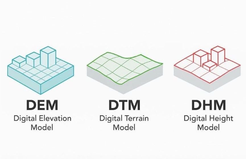
The most important thing to understand is that DEM should be treated as a general category of elevation data. It is a broader term that can refer to both DTM (Digital Terrain Model) and DSM (Digital Surface Model). This distinction is essential when working with elevation datasets because each model serves different purposes and is derived in different ways. In some countries and institutions, DEM is used synonymously with DTM, but for clarity and precision it is better to consider DEM as an umbrella term encompassing both.
DSMs are particularly useful in applications that require knowledge of the actual surface visible from above. For example DSMs are used in:
Line-of-sight analysis for telecommunications
Solar potential assessments
Urban planning and visibility studies
Forest canopy analysis
Disaster risk assessments in built environments, including modeling debris flow, wildfire spread, and visibility from surveillance points
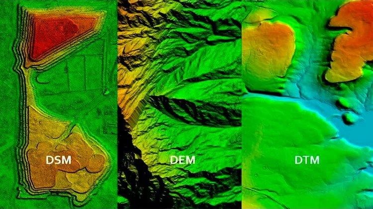
Key Differences Between DSM and DTM
A Digital Surface Model (DSM) represents the elevation of the Earth's surface including all natural and man-made features. That means it captures the tops of buildings, trees and other structures. DSMs are particularly useful in applications that require knowledge of the actual surface visible from above. For example DSMs are used in line-of-sight analysis for telecommunications, solar potential assessments, urban planning and visibility studies. Since DSM includes vegetation and buildings it is also critical in forest canopy analysis and disaster risk assessments in built environments. Emergency planners use DSMs to model debris flow, wildfire spread and visibility from surveillance points.
In contrast a Digital Terrain Model (DTM) represents the elevation of the bare ground surface with all vegetation and built structures removed. This is the model of the actual terrain or topography. DTM is indispensable for hydrological modeling such as flood risk mapping, watershed delineation and soil erosion studies. It is also used in infrastructure design, geological analysis and archaeological research where understanding the raw terrain is crucial. In agriculture, DTMs help analyze slope and aspect to optimize land management. In renewable energy, DTMs support wind farm site selection and landscape impact assessments.
The distinction between DEM, DTM and DSM is not always applied consistently. In some practices DEM refers specifically to bare-earth models while in others it refers to any elevation model regardless of what features it includes. This can create confusion so it is important to always verify what the term refers to in each context.
Specialized Elevation Models: CHM and DHM
Beyond DSM and DTM there are also more specialized elevation products. One common example is the Canopy Height Model (CHM), which is typically calculated as the difference between DSM and DTM. CHMs are widely used in forestry to estimate tree height, canopy structure and above-ground biomass. These derivative models support monitoring of deforestation, carbon storage and biodiversity. In some contexts the term Digital Height Model (DHM) is also used, though its meaning can vary. It may refer to canopy height or other relative elevation models depending on the application, such as habitat suitability or landscape structure analysis.
Satellite and Aerial Data Sources for Elevation Models
Now where do we get the data to generate these models? The source depends on the required resolution and purpose.
Stereo imagery from optical satellites
One of the most common methods is stereo imagery from optical satellites, such as WorldView, Pleiades or SPOT. These satellites capture images from slightly different angles allowing software to reconstruct the 3D structure of the terrain. The advantage of satellite stereo is that it covers large areas and can be updated frequently. However, it may be less accurate in densely vegetated or urban areas.
SAR (Synthetic Aperture Radar)
Another major source is SAR (Synthetic Aperture Radar), for example from missions like SRTM and TanDEM-X. These systems use radar interferometry to capture elevation data even through cloud cover and at night, making them ideal for persistent-cloud regions such as the tropics. The SRTM mission, flown aboard the Space Shuttle in 2000, produced the first near-global Digital Surface Model (DSM). Initially, the data were released at 30-meter resolution for the United States and at 90-meter resolution for the rest of the world. A global 30-meter version was later released and remains widely used in global-scale studies.
LiDAR (Light Detection and Ranging)
LiDAR is another excellent source of elevation data known for its exceptional accuracy, particularly when collected from aircraft or unmanned aerial vehicles (UAVs). Airborne LiDAR is frequently used to produce high-resolution DTMs by filtering out returns from vegetation and structures, isolating the ground surface. Drones equipped with photogrammetric or LiDAR sensors are increasingly applied in localized mapping tasks such as construction monitoring, infrastructure planning and precision agriculture. In forestry, LiDAR is uniquely suited for generating both DTM and DSM from a single flight, enabling the creation of accurate canopy height models for biomass estimation and vegetation analysis.
Applications and Accessibility of Elevation Data
Thanks to growing open data initiatives and commercial satellite missions elevation data is now more accessible than ever. Users can find elevation products through global platforms that support geographic analysis and 3D modeling.
Elevation datasets are widely used in:
Geographic Information Systems (GIS)
Sustainable development projects
Disaster response and risk management
Scientific research
Conclusion: Choosing the Right Elevation Model
To sum up DEM is a high-level concept referring to digital representations of elevation. It includes both DSM and DTM each with its specific applications. DSM captures surface features while DTM shows the bare earth. Depending on your use case choosing the right elevation model and knowing its source is key to getting accurate results. With increasing availability of satellite data and cloud-based processing platforms creating up-to-date and high-resolution DEMs is becoming more accessible than ever before. The more we understand these models and how they are created the better we can use them for supporting sustainable development, disaster response and scientific research.
Related articles
- How Satellite Imagery Works: From Space to Your Screen
- What is GEOINT? The Power and Limits of Geospatial Intelligence in the Modern World
- What Is Satellite Imagery? A Complete Beginner’s Guide
- Satellite Imagery vs Aerial Photography: Key Differences Explained
- Satellite Imagery: Definition and Applications in 2026