Beyond the Blackout: What Satellites Reveal Behind Iran's Information Shield
When a state pulls the curtain of a digital blackout across its borders, the ground goes silent but the sky does not.
In moments of peak geopolitical friction, information inside Iran often enters a vacuum. Internet kill-switches, restricted media access, and tightly controlled state narratives can turn the country into a "black box" for journalists and policymakers. Yet, while fiber-optic cables can be severed and reporters sidelined, the steady gaze of commercial Earth-observation satellites remains unbroken.
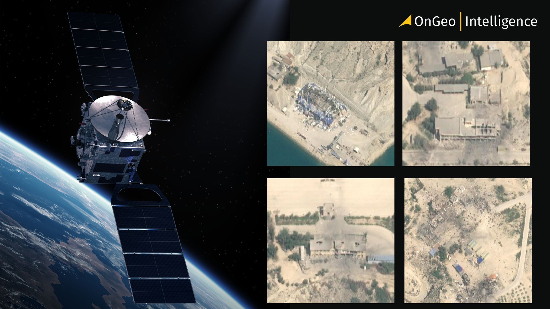
Satellite Imagery The Silent Witness
Modern satellite constellations from the high-revisit cadences of Planet Labs to the sub-meter precision of Maxar (Vantor) operate beyond the reach of terrestrial censorship. They provide a continuous, verifiable record of physical events. Even when official sources provide limited or contradictory information, orbital sensors continue to capture activity on the ground:
- Thermal signatures revealing the activation of underground facilities.
- Synthetic Aperture Radar (SAR) piercing through cloud cover to track the sudden mobilization of mobile missile launchers.
- High-resolution "after" shots that map the precise geometry of a strike’s impact.
Satellite Imagery as Geospatial Evidence
In this environment, satellite imagery does more than provide pictures; it provides forensic proof. Strategic adaptation is written directly onto the Iranian terrain visible in the fresh scarring of high-security perimeters, the expansion of fortified mountain sites, and the tell-tale scorch marks on concrete that verify a successful kinetic operation.
Looking beyond the blackout, we find a landscape where the physical world refuses to keep the secrets of the digital one. In the age of the "Information Shield," the most critical intelligence is no longer found on the wires, but in the pixels captured from 500 kilometers above.
Visualizing the Void: When High-Resolution Imagery Meets Strategic Silence
While state-run narratives often rely on the fog of war, the 0.3-meter resolution of modern commercial satellites acts as a high-powered lens that cuts through the haze. In the wake of the February 28 "Operation Epic Fury" strike, the digital blackout served a dual purpose: to manage domestic perception and to obscure the physical reality of the damage. However, you cannot hide a crater from a sun-synchronous orbit.
The Anatomy of a "Before and After" Analysis
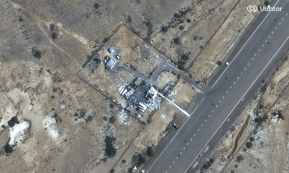
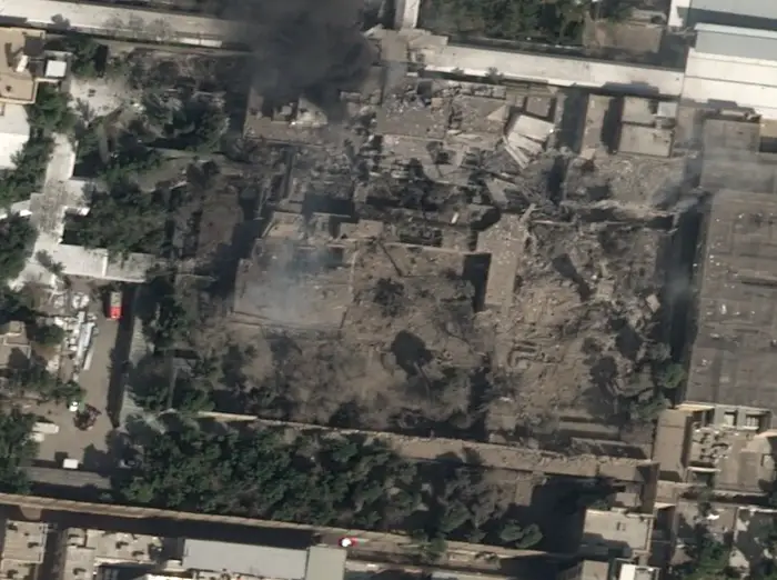
Satellite forensics rely on change detection algorithms software that highlights the exact pixels that have shifted between two points in time. When we look at the imagery of the Beit Rahbar (the Leader's House), the data tells a story that transcends official statements:
- Precision Entry: The "after" shots reveal a gaping hole localized in the central administrative wing, suggesting a surgical strike rather than carpet bombing.
- Logistical Echoes: In the hours following the strike, orbital passes captured a surge in emergency vehicle clusters and the rapid deployment of specialized security cordons physical markers of a high-value crisis.
- The Scorched Signature: Thermal sensors captured residual heat signatures from the site long after the initial blast, providing a "thermal fingerprint" of the munitions' impact.
From Imagery to Verification
In this context, the satellite is no longer just a camera; it is a geospatial notary. It provides an immutable record of structural failure and tactical success. By layering optical imagery with Synthetic Aperture Radar (SAR) which can "see" through the smoke of a fresh blast analysts can verify the success of a mission like Operation Epic Fury in real-time, even while the target remains under a total communications shroud.
The Information Blackout Strategy: Control Through Digital Silence
In the modern geopolitical arena, the first move in any crisis is rarely kinetic it is informational. When "Operation Epic Fury" unfolded on February 28, the immediate response followed a well-worn tactical playbook: the systematic severing of the "digital nervous system."
Such measures create an environment in which:
- Unverified reports and speculation spread rapidly.
- State media narratives face less immediate challenge.
- Independent verification of damage and casualties becomes difficult.
While these tactics can delay the global flow of information, they cannot prevent satellite observation from documenting physical events from orbit.
Satellite Data as an External Source of Verification
Satellite imagery provides an external, non‑state source of verification that is difficult to suppress. Sensors record measurable physical changes over time, producing datasets that can be revisited, reanalyzed, and cross‑referenced by multiple independent parties.
Commercial availability of this data has fundamentally changed the transparency of modern conflicts. Once imagery is captured, it becomes part of a distributed archive maintained by commercial providers and research institutions, limiting the ability of any single actor to suppress or alter the record.
Multi‑Spectral Observation: Seeing Beyond Visual Damage
Different satellite sensors contribute complementary perspectives:
- High‑resolution optical imagery reveals visible structural damage and surface disruption.
- Synthetic Aperture Radar (SAR) enables observation through smoke, clouds, and darkness.
- Thermal sensors help identify heat anomalies associated with fires, explosions, or underground activity.
Together, these layers provide a more complete understanding of events than any single data source could offer.
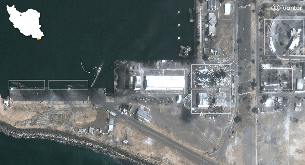
Case Study: Damage at the Beit Rahbar Compound
Satellite imagery captured in the days following the strike on the Beit Rahbar complex revealed significant structural damage to the central administrative wing. The pattern of destruction suggested the use of bunker‑penetrating munitions designed to target reinforced facilities.
Because official communication channels provided limited detail, this geospatial evidence played a central role in informing international assessments of the event and its potential political consequences.
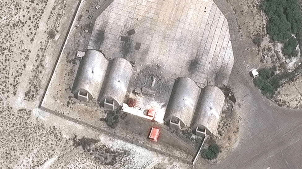
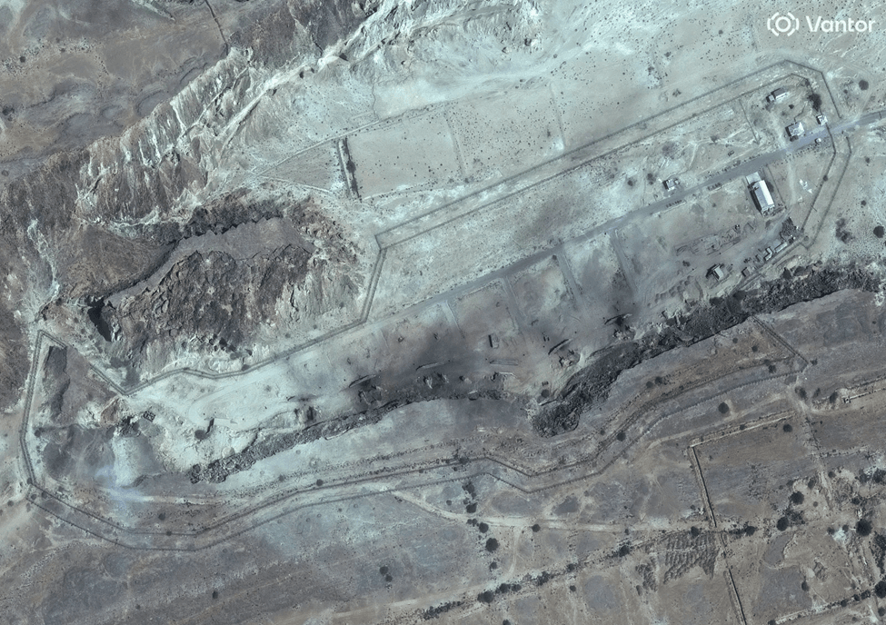
Strikes on Underground Missile Infrastructure
Satellite imagery also documented damage to underground missile tunnel networks in northwestern Iran near Tabriz. Collapsed tunnel entrances and impact craters were visible at surface access points, indicating that the strikes were intended to disable logistical pathways rather than destroy buried assets directly.
This approach effectively trapped equipment within hardened mountain facilities, limiting the immediate operational use of those missile systems.
How OnGeo Intelligence Applies in This Context
When access to information inside a country is restricted, satellite imagery becomes a key source of insight. Platforms such as OnGeo Intelligence provide centralized access to high-resolution imagery from multiple providers, allowing analysts to monitor locations, compare current and historical data, and detect changes over time. Time-series analysis and measurement tools help identify construction, damage, or operational shifts and quantify their scale. Although they do not replace on-the-ground reporting, such platforms offer a crucial supplementary perspective, ensuring that observable developments remain visible even when official information is limited.
Capture the world at 100% OFF! Use code ongeo100 on 10 meters satellite image resolutions – limited time only!
Higher resolution satellite images remain subject to payment.
The Limits of the Information Shield
Digital blackouts can slow the spread of information, but they cannot conceal large‑scale physical changes. Satellite imagery ensures that major structural damage, infrastructure disruption, and large troop movements remain observable to the outside world.
As commercial space capabilities continue to expand, the gap between attempts at information control and the availability of independent verification is likely to narrow further. In this environment, satellite data has become an essential component of modern conflict monitoring, providing a persistent and impartial view of events that unfold beyond the reach of traditional reporting.
Related articles
- Satellite Imagery Reveals Widespread Destruction Across the Middle East
- Why Metadata Is Essential in Satellite Earth Observation
- Satellite Images Reveal Devastating Before-After Views of Gaza City
- Lebanon Bombing: Satellite Images Reveals Scale of Destruction
- Satellite imagery of Gaza reveals the massive scale of destruction