
Satellite Imagery Reveals Widespread Destruction Across the Middle East
While diplomats argue in they lead the narratives, the truth is being captured in multi-spectral. As the war between Iran and Israel intensifies, the frontline has moved into the lens of commercial satellites. We no longer have to wonder if a strike was successful; we can count the burn scars and measure the debris fields from 300 miles up. From the precision-leveled blocks of Beirut to the thermal signatures of burning refineries in the Gulf, the footprint of this war is being mapped in near real-time. This is a breakdown of the visible evidence: what the pixels confirm, what the clouds are hiding, and what the latest imagery tells us about the cost of this regional explosion.
Strike Impact Patterns Visible From Orbit
High-resolution satellite imagery reveals distinct physical signatures left by recent strikes across multiple locations in the Middle East. From orbit, impact zones are identifiable through crater formations, blast discoloration, and structural fragmentation patterns that differ clearly from natural or accidental damage.
In open terrain, fresh craters appear as sharply defined circular or elliptical depressions surrounded by ejecta rings and burn scars. Their size and shape can provide clues about munition class and detonation type, though imagery alone cannot definitively identify the exact weapons used. In paved environments
From orbit, the patterns are unmistakable: precise, concentrated, and geographically dispersed across key nodes of infrastructure.
A Region Transformed: From Tehran to Dubai
The imagery reveals a multi-front footprint that stretches across thousands of miles.
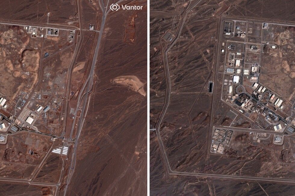
- In Iran: Images show the precise "surgical" nature of strikes on the Natanz nuclear facility and the IRGC command centers in Tehran.
- In the Gulf: We see the economic fallout in the form of smoke plumes over Jebel Ali Port and the charred remains of intercepted debris on the Palm Jumeirah, marking the first time these global tourism hubs have appeared in combat-related satellite data.
- In Lebanon: Imagery confirms the systematic leveling of entire blocks in Dahiyeh, alongside the rapid formation of a new "scorched earth" buffer zone along the Litani River.
The consequences of the war in Tehran: Dubai’s Skyline Under Siege
The ongoing conflict has hit the UAE with unprecedented force, marking a historic shift in regional security. Since the start of the joint US-Israeli "Operation Epic Fury" on February 28, 2026, the UAE has faced a barrage of hundreds of drones and missiles as part of Iran's retaliatory "Operation True Promise IV."
Here is a breakdown of the specific effects on the UAE as of March 5, 2026:
1. Direct Attacks & Infrastructure Damage
While the UAE's air defense systems have intercepted the vast majority of incoming threats, the volume of the assault has led to significant "leaks" and damage from falling debris:
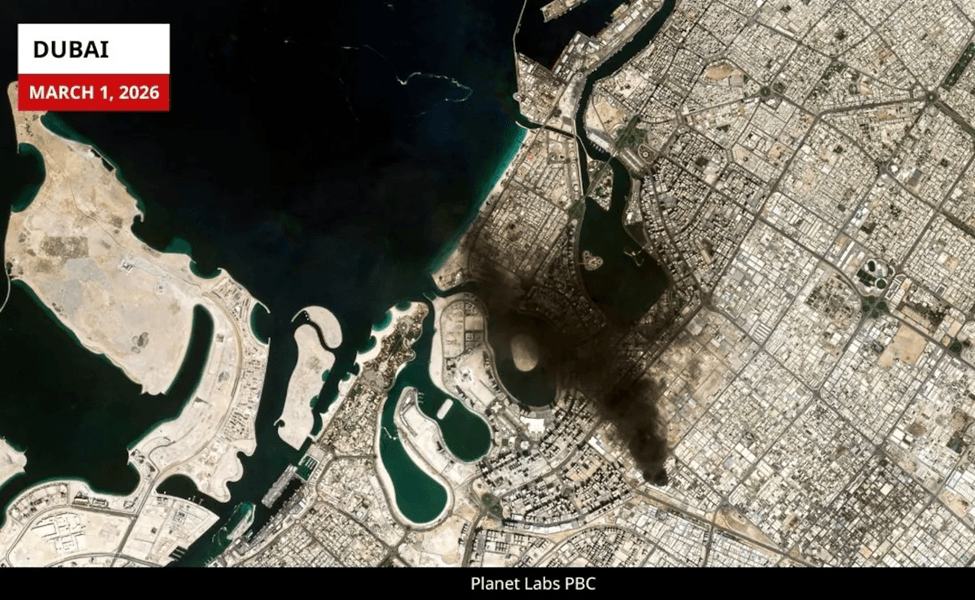
- Dubai International Airport (DXB): On March 1, Terminal 3 sustained damage from an air strike. All scheduled flights are currently suspended until at least March 7, leaving thousands of travelers stranded.
- The Palm Jumeirah & Burj Al Arab: A Shahed-type drone struck near the Fairmont The Palm, causing a major fire. Shrapnel and interception debris have also caused visible damage to the exterior of the Burj Al Arab.
- Industrial Hubs: Fires were reported at Jebel Ali Port and an oil depot in Fujairah following drone strikes and interceptions on March 4.
2. Economic and Logistics Paralysis
The UAE, which prides itself on being a global hub for business and tourism, has seen its "oasis of stability" reputation severely tested:
- Aviation: Both Emirates and Etihad have suspended nearly all commercial operations. The regional airspace is effectively a "no-fly zone" for civilian carriers.
- Energy Costs: Domestic fuel prices for March 2026 have already jumped (Super 98 is now Dh 2.59/litre) as markets factor in the "war tax" and the effective closure of the Strait of Hormuz.
- Business Operations: Major data centers, including an AWS facility, reported localized power issues and fire damage after being struck by objects during the aerial exchanges.
| Drones Launched | Missiles Launched | Economic Target | Civilian Hubs |
| ~500+ | ~150+ | Jebel Ali / Fujairah | DXB Airport / Palm Jumeirah |
Fuel and Fire: Satellite Evidence of Saudi Arabia’s Economic Scars
Saudi Arabia has moved from a position of wary neutrality to a state of high military alert. While the UAE bore the brunt of the initial retaliatory wave, the focus has shifted toward the Kingdom’s critical energy infrastructure.
Here is how the conflict is currently reshaping Saudi Arabia:
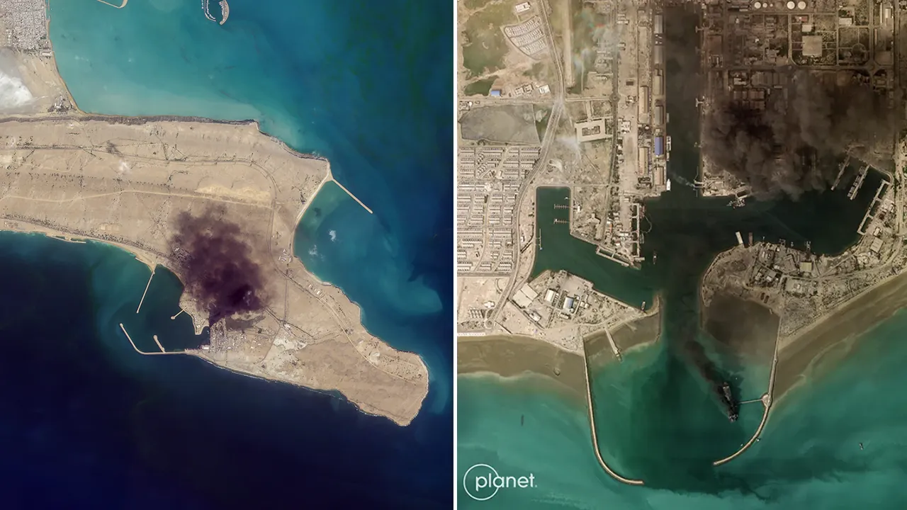
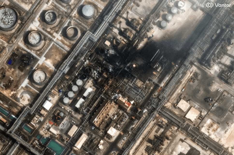
1. The Battle for Energy: Ras Tanura
On March 2, 2026, the "tacit bargain" of avoiding energy targets was shattered.
- The Attack: Two Iranian drones targeted the Ras Tanura refinery, the world’s largest oil stabilization plant.
- Satellite Evidence: High-resolution imagery confirmed smoke plumes rising from the facility. While the Saudi Ministry of Defense reported that the fire was quickly contained with "minor material damage," the psychological impact was immediate global oil prices surged by 8% within hours.
- The Response: Saudi Aramco has temporarily halted some Gulf-side operations, attempting to reroute crude exports via the East-West Pipeline to the Red Sea to bypass the now-blocked Strait of Hormuz.
2. Diplomatic Violations in Riyadh
The conflict reached the capital on March 2 with a direct strike on the diplomatic quarter.
- US Embassy Hit: Two Iranian drones struck the US Embassy compound in Riyadh, causing fires and minor structural damage.
- The Red Line: The Saudi Cabinet, chaired by Crown Prince Mohammed bin Salman, condemned the strike as a "flagrant violation of international law." The Kingdom has since authorized a "full military response" should further sovereignty violations occur.
3. The "Locked and Loaded" Stance
Unlike previous years of de-escalation, the Saudi military posture in 2026 is overtly aggressive:
- Air Defense Success: Major General Turki Al-Maliki confirmed that Saudi air defenses (Patriot and THAAD systems) intercepted eight drones and two cruise missiles targeting Riyadh and Al-Kharj on March 3 alone.
- US Cooperation: While the Kingdom maintains it did not allow its airspace to be used for the initial "Operation Epic Fury" strikes, it is now working in "total lockstep" with US CENTCOM for regional defense.
| Sector | Current Status | Notable Incident |
|---|---|---|
| Energy | Critical | Ras Tanura refinery hit; operations partially suspended. |
| Aviation | Disrupted | Major flight cancellations; Saudi airspace highly restricted. |
| Military | Active Defense | Intercepting daily drone swarms from the north and south. |
| Diplomacy | Severed | Embassy in Tehran closed; direct warnings of retaliation issued. |
Lebanon Under the Lens: The Visual Toll of 'Operation Lion’s Roar'
In Lebanon, the conflict has rapidly devolved into a high-intensity "second front" following Hezbollah’s entry into the war on March 2, 2026.
The Situation in Brief (as of March 5, 2026):
- Beirut Under Fire: Israeli "Operation Lion’s Roar" has targeted the Dahiyeh (southern suburbs) with waves of heavy airstrikes. Satellite images confirm the collapse of multiple residential and command buildings, with smoke plumes visible over the capital daily.
- Mass Displacement: In just 96 hours, over 83,000 people have been internally displaced. Schools in Beirut and central Lebanon are at capacity, serving as makeshift shelters.
- Casualties: The Lebanese Health Ministry reports at least 72 deaths and hundreds of injuries since Monday, with strikes expanding beyond traditional Hezbollah strongholds into areas like Hazmieh and Aramoun.
- Political Rupture: The Lebanese government, led by PM Nawaf Salam, has taken the historic step of condemning Hezbollah’s actions as "illegal," officially banning the group's military activities in an attempt to shield the state from total destruction.
Israel is operating at the epicenter of a multi-front regional war. While it is the primary aggressor in "Operation Roaring Lion" (targeting Iran and Lebanon), it is also facing its most significant domestic defense challenge in decades.
Focusing on Israel-Iran-Lebanon
1. The Home Front: Under a Missile Umbrella
Despite the "Iron Beam" laser systems and high-tier Arrow-3 interceptions, the sheer volume of Iran’s "Operation True Promise IV" has led to direct hits:
- The Tel Aviv Corridor: Satellite imagery from March 5 shows impact craters and shrapnel damage in the northern suburbs of Tel Aviv and the Herzliya business district. While casualties have been kept low due to an disciplined "bunker culture," the structural damage to high-end real estate is visible from space.
- Military Bases: Several Israeli Air Force (IAF) bases, including Nevatim and Hatzerim, have been targeted by Iranian "Ghadr" ballistic missiles. Satellite shots confirm damage to taxiways and hangars, though the IAF maintains its "operational tempo" remains at 100%.
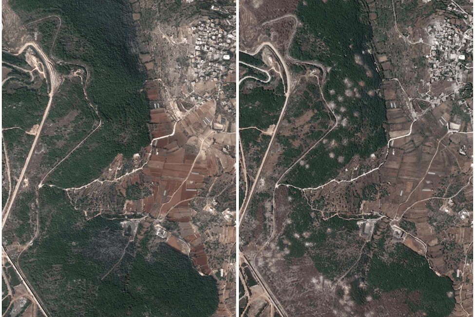
2. The Northern Front: The Lebanon Incursion
Israel’s ground war has officially crossed the border into Lebanon to neutralize Hezbollah’s launch sites:
- The "Dead Zone": High-resolution imagery shows a 10km-wide strip of scorched earth along the Blue Line. Over 55 Lebanese villages have been cleared of buildings used for missile storage, creating a stark visual "buffer" that didn't exist two weeks ago.
- Mobilization: Satellite data captures massive Israeli armored columns and artillery batteries staged in the Galilee, signaling that the ground incursion is likely to expand deeper into Lebanon toward the Litani River.
3. The Elimination of Iranian Leadership
Israel’s primary focus remains "elimination" the Iranian leadership.
- Intelligence Success: It was Israeli intelligence that geolocated Ayatollah Ali Khamenei on February 28, leading to the joint strike that killed him.
- Satellite Confirmation: Before-and-after photos of the Beit Rahbar (the Leader's House) in Tehran show a direct hit on the central administrative wing, a symbolic and strategic blow that has sent the Iranian regime into a tailspin.
Area | Status | Key Visual Detail |
Airspace | Contested/Active | Constant "thermal blooms" from interceptions over Tel Aviv/Haifa. |
Northern Border | Active Ground War | Massive IDF armored formations visible moving into Lebanon. |
Nuclear Sites | Offensive | IAF strikes confirmed at Natanz and Isfahan sites. |
Domestic Safety | High Alert | Millions in shelters; "Iron Beam" active for the first time in combat. |
How OnGeo Intelligence Fits Into the Analysis
In fast-moving regional conflicts, access and speed are everything. Satellite imagery is powerful but only if analysts can quickly locate, compare, and measure it. This is where OnGeo Intelligence becomes operationally relevant.
1. Rapid Access to High-Resolution Imagery
OnGeo Intelligence aggregates commercial satellite data into a searchable interface, allowing analysts to acquire imagery over specific strike zones without navigating multiple vendors. In a developing situation, the ability to task or retrieve recent captures quickly can determine how timely an assessment is.
2. Historical Archive for Before-and-After Comparison
Conflict analysis depends on baseline imagery. OnGeo Intelligence archive enables structured time-series comparison identifying what existed before a strike and quantifying what changed afterward. This supports:
- Crater measurement
- Building footprint comparison
- Runway damage assessment
- Infrastructure expansion or repair tracking
3. Structured Workflow for Intelligence Teams
For researchers, journalists, and policy analysts, workflow efficiency matters. OnGeo Intelligence reduces the friction between identifying an event and obtaining usable imagery, enabling structured reporting rather than reactive commentary.
Capture the world at 100% OFF! Use code ongeo100 on 10 meters satellite image resolutions – limited time only!
Higher resolution satellite images remain subject to payment.
Conclusion: What do satellite images of Iran, Israel and the Middle East say?
In a region shaped by rapidly evolving military exchanges and competing political narratives, satellite imagery provides one of the few consistent reference points. From airbase runway scarring to urban structural damage and industrial facility impacts, the physical footprint of recent strikes is visible from orbit.
What these images show is measurable change: craters where there were none, collapsed rooftops, scorched compounds, patched runways, and reinforced perimeters. What they do not show are motives, intentions, or the full human consequences of conflict. That distinction matters.
As tensions across the Middle East continue to unfold, the ability to compare imagery over time will be critical in determining whether events represent temporary escalation or a more sustained strategic shift. Time-series analysis, high-resolution data, and structured geospatial workflows allow observers to move beyond speculation and toward evidence-based assessment.
In modern conflict, information travels instantly but verification does not always keep pace. Satellite imagery narrows that gap. It anchors analysis in observable reality, offering a spatial record of destruction, adaptation, and resilience. And as long as the situation evolves, the view from space will remain one of the clearest lenses through which it can be understood.
Related articles
- Maxar and Satellogic Partner to Advance Geospatial Intelligence
- Essential Tips for Interpreting Satellite Imagery Like a Pro
- Satellite imagery of Gaza reveals the massive scale of destruction
- Satellite Images Reveal Devastating Before-After Views of Gaza City
- How Satellite Imagery Improves Crisis Management and Disaster Response
- War in Sudan: How Satellite Imagery Reveals Hidden Atrocities
- Maxar Restores Ukraine’s Access to Satellite Imagery
- Beyond the Blackout: What Satellites Reveal Behind Iran's Information Shield