Iran Satellite Imagery: Geopolitical Intelligence
The sky is no longer a secret and for Iran, that means every move is being watched.
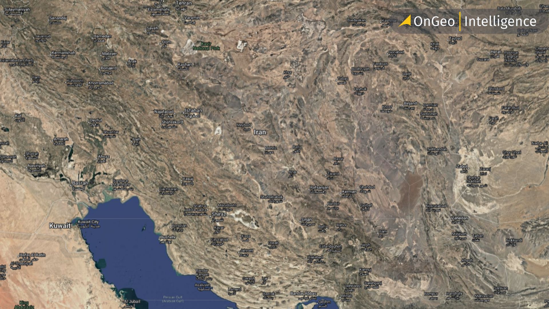
Once, only governments could spy from space. Now, commercial satellites beam back razor-sharp images for anyone willing to pay, turning the Middle East's most closely scrutinized nation into an open-air intelligence theater. From nuclear facilities and missile development sites to naval movements in the Persian Gulf, satellite imagery now plays a central role in understanding Tehran’s strategic posture.
High-resolution imagery, combined with open-source analysis, allows researchers, policymakers, and defense analysts to track infrastructure expansion, detect unusual activity, and assess regional security risks in near real time. This article explores what satellite data reveals about Iran’s military and strategic infrastructure and how modern geospatial platforms are transforming raw imagery into actionable intelligence.
Fortification and Reconstruction After Conflict
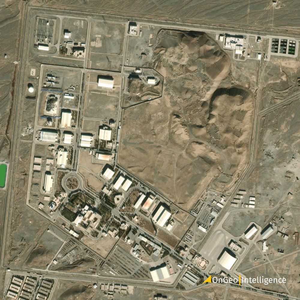
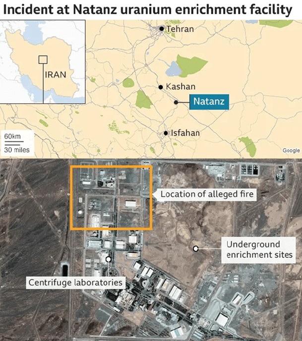
Satellite imagery helps track how strategic sites are rebuilt after strikes or sabotage. In Iran, high-resolution imagery data shows reconstruction at sensitive military and nuclear facilities, including reinforced structures, expanded security perimeters, and underground development at sites such as Natanz Nuclear Facility.
Analysts monitor excavation marks, new access roads, and tunnel expansions to assess shifts toward hardened or concealed infrastructure. By comparing historical and current imagery, they can measure the scale and speed of rebuilding. Rapid fortification often signals strategic importance and heightened threat awareness.
Monitoring Missile and Military Infrastructure
Satellite imagery plays a central role in assessing the scale, distribution, and evolution of Iran’s missile and military infrastructure. Unlike traditional intelligence gathering, space-based monitoring enables continuous, wide-area observation making it possible to detect both gradual expansion and sudden activity shifts.
Imagery analysis has focused on facilities linked to Iran’s ballistic missile program, including complexes near Khorramabad and Isfahan, where large storage compounds, launch support structures, and hardened shelters have been observed. Analysts typically examine patterns such as new warehouse construction, reinforced bunker entrances, and the extension of internal road networks each of which can indicate logistical scaling or operational readiness.
One key advantage of satellite monitoring is change detection. By comparing imagery over time, analysts can identify:
- Expansion of missile storage depots;
- Development of underground tunnel systems;
- Construction of new launch pads or test stands;
- Increased vehicle activity within secured perimeters.
In addition, airbases and air defense sites provide further context. Satellite data may reveal runway extensions, hardened aircraft shelters, radar installations, and surface-to-air missile placements. While imagery does not disclose internal capabilities, it offers measurable indicators of infrastructure growth and strategic positioning.
Naval infrastructure is equally important. Ports along the Persian Gulf are routinely observed for vessel movements, dock expansion, and new support facilities. Changes in dry dock size, pier reinforcement, or fleet composition provide clues about modernization efforts and force projection capacity.
Overall, satellite imagery transforms physical infrastructure into analyzable data. By mapping facilities, measuring expansion rates, and identifying new construction patterns, geospatial intelligence provides a structured view of military capability development grounded in observable evidence rather than speculation.
Nuclear Facility Concealment and Hardening
As international scrutiny of Iran’s nuclear program has intensified, satellite imagery has revealed a parallel trend: increased efforts toward concealment and structural hardening. These measures are designed to reduce vulnerability, limit visibility, and enhance survivability under potential strike scenarios.
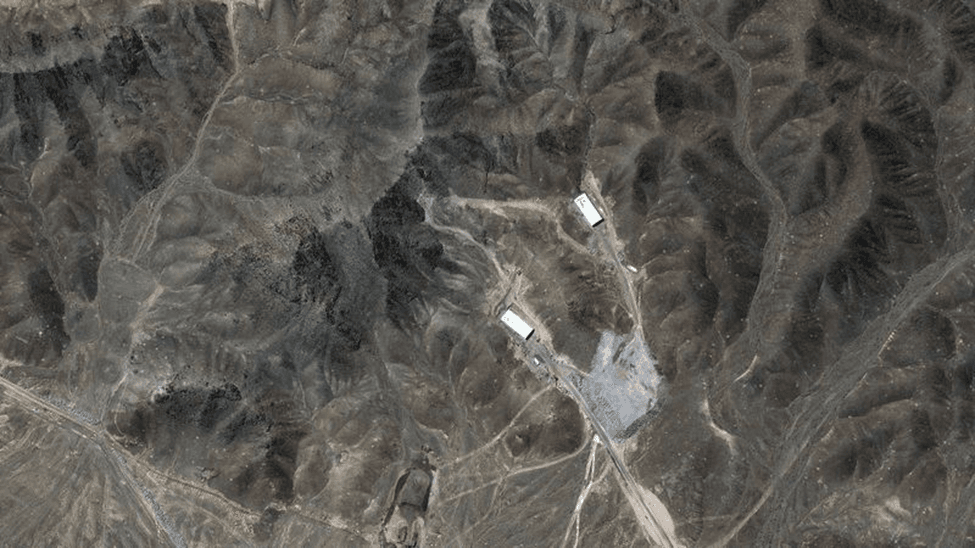
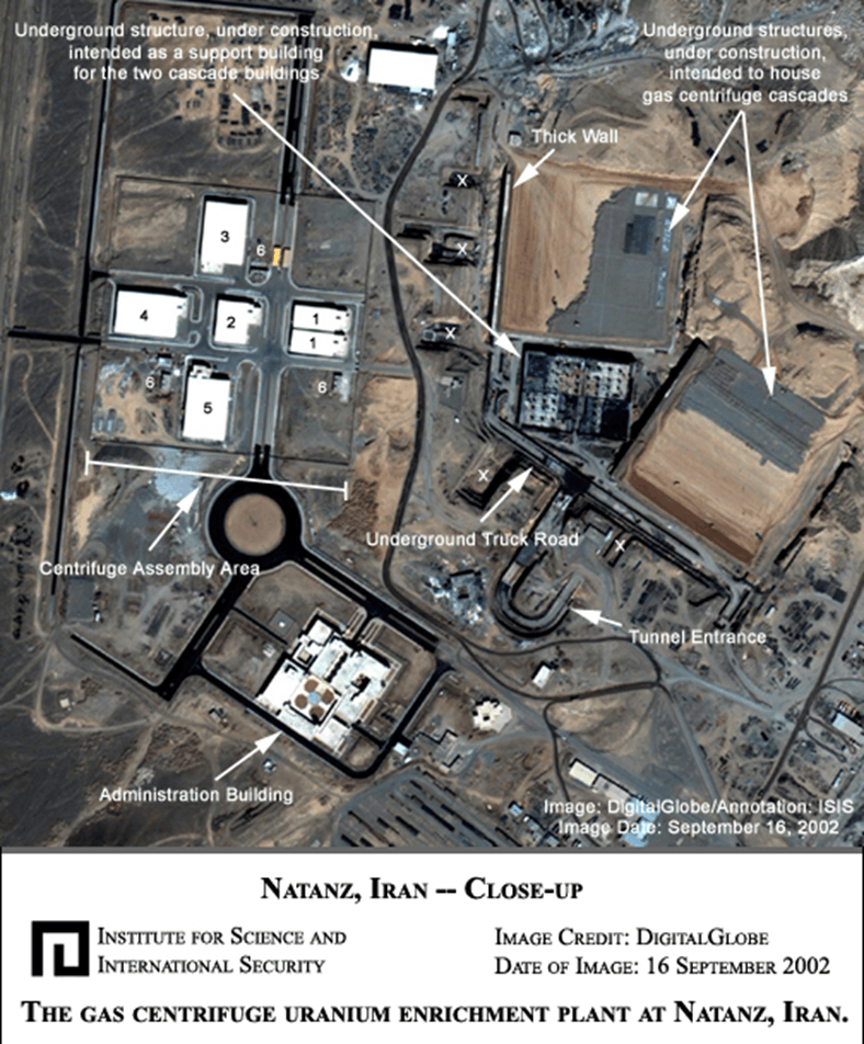
One of the most closely analyzed sites is Fordow Fuel Enrichment Plant. Built deep within a mountain, Fordow represents a clear example of hardened infrastructure. From space, analysts can observe tunnel entrances, reinforced portal structures, security perimeters, and support buildings while understanding that much of the facility’s operational footprint lies underground. Terrain analysis and shadow measurements help estimate tunnel depth and construction scale.
Similarly, continued observation of Natanz Nuclear Facility has shown patterns consistent with post-incident fortification. These include thicker roofing structures, reconfigured electrical substations, and the expansion of subterranean halls. Excavation scars, soil displacement, and the staging of heavy machinery often signal new underground construction even when internal activity remains concealed.
Concealment strategies visible via satellite imagery may include:
- Construction of facilities adjacent to natural terrain features;
- Use of camouflage netting or roofing materials that reduce spectral contrast;
- Dispersal of key assets across multiple smaller compounds;
- Expansion of buffer zones and layered perimeter defenses.
Multispectral and thermal imaging further enhance analysis. Changes in surface temperature patterns can indicate operational activity, while vegetation disturbance around tunnel systems may signal recent excavation.
Importantly, satellite imagery does not confirm intent or capability but it does document physical preparation. Patterns of concealment and hardening offer measurable indicators of strategic caution and defensive planning. In geopolitical analysis, these observable changes help contextualize diplomatic developments, inspections, and regional security dynamics.
Through consistent monitoring, satellite intelligence turns structural design choices into signals revealing how infrastructure itself reflects broader strategic calculations.
The Value of Time-Series and High-Resolution Data
Single images provide snapshots. Time-series and high-resolution imagery provide narratives.
In geopolitical intelligence, the true analytical edge comes from comparing imagery across weeks, months, and years. A lone satellite pass may show a completed structure but a structured time-series reveals how and when it was built, how quickly it expanded, and whether activity accelerated after specific political or military events.
For sites such as Natanz Nuclear Facility or Fordow Fuel Enrichment Plant, time-based analysis allows analysts to:
- Track excavation phases and tunneling progress
- Measure construction speed and workforce scaling
- Detect pauses that may correspond with negotiations or inspections
- Identify rapid fortification following reported incidents
High-resolution data enhances this further. Sub-meter imagery enables precise measurement of building dimensions, blast wall thickness, vehicle presence, and security layouts. Fine spatial detail allows for accurate object classification distinguishing between storage structures, administrative buildings, radar arrays, or hardened shelters.
Temporal stacking also improves confidence. Repeated observations reduce misinterpretation caused by shadows, seasonal vegetation, or temporary staging. When changes persist across multiple passes, they become structural signals rather than noise.
Beyond nuclear facilities, time-series analysis of missile depots, airbases, and naval ports transforms infrastructure into quantifiable metrics: expansion rates, construction density, perimeter growth, and logistics scaling. These measurable indicators support more grounded geopolitical assessments.
Ultimately, time and resolution are force multipliers in geospatial intelligence. They convert isolated images into evidence chains allowing analysts to move from “what is there” to “what is changing” and, more importantly, “what that change suggests.”
What Satellite Intelligence Does and Doesn’t Reveal
Satellite intelligence offers powerful visibility into physical infrastructure but it is not omniscient. Understanding its strengths and limits is essential for responsible geopolitical analysis.
What it reveals
Satellite imagery excels at documenting observable, physical change. It can show:
- Construction of new facilities or expansion of existing compounds;
- Excavation patterns suggesting underground development;
- Runway extensions, hardened shelters, and defensive perimeters;
- Vehicle concentrations and logistical staging areas.
For example, imagery of sites like Natanz Nuclear Facility or Fordow Fuel Enrichment Plant can confirm structural hardening, new tunneling, or facility enlargement. These are measurable, documentable changes grounded in physical evidence.
Similarly, monitoring airbases, missile complexes, and naval ports can reveal capacity growth and modernization trends. Satellite data transforms terrain and concrete into quantifiable indicators: square meters built, earth moved, shelters added, perimeters reinforced.
What it does not reveal
However, imagery cannot directly show:
- The internal status of enrichment cascades;
- Warhead design or weaponization progress;
- Command decisions or strategic intent;
- Operational readiness beyond visible preparation.
A reinforced bunker does not automatically indicate imminent action. A new structure does not confirm its function without corroborating intelligence. Imagery captures capability development in physical form but not doctrine, timelines, or political calculation.
The analytical balance
The real value lies in integration. Satellite intelligence becomes most powerful when combined with diplomatic reporting, inspection data, policy shifts, and regional security developments. It narrows uncertainty but rarely eliminates it.
For geopolitical intelligence platforms and for emerging AI-driven geospatial systems the responsibility is clear: distinguish between observation and inference. Satellite data provides evidence of infrastructure. Interpretation must remain disciplined, transparent, and proportionate to what is actually visible.
In an era of rapid information flow, that distinction is not a limitation it is credibility.
How OnGeo Intelligence Helps in the Mix
Satellite intelligence is only as powerful as the infrastructure that delivers, processes, and contextualizes it. This is where platforms like OnGeo Intelligence enter the equation bridging raw imagery and actionable geopolitical insight.
Capture the world at 100% OFF! Use code ongeo100 on 10 meters satellite image resolutions – limited time only!
Higher resolution satellite images remain subject to payment.
1. Access to Commercial High-Resolution Imagery
OnGeo Intelligence aggregates data from multiple commercial satellite providers, enabling analysts to access high-resolution optical imagery across regions of interest. Instead of negotiating with individual vendors, users can search, task, and acquire imagery through a centralized interface streamlining the workflow for monitoring sensitive facilities.
2. Time-Series Comparison Tools
For geopolitical monitoring whether assessing infrastructure near Natanz Nuclear Facility or tracking activity patterns at strategic ports temporal comparison is essential. OnGeo’s archive search and historical imagery access allow analysts to build structured timelines of construction, excavation, and fortification activity.
3. Workflow Efficiency for Intelligence Teams
For researchers, journalists, and security analysts, speed matters. OnGeo reduces friction in sourcing imagery, allowing teams to focus on interpretation rather than acquisition logistics. This is particularly valuable when monitoring rapidly evolving geopolitical events.
4. Integration Potential with AI Systems
As AI-driven geospatial pipelines mature, platforms like OnGeo provide structured imagery access that can feed into automated change detection, object classification, and anomaly detection models. The future of geopolitical intelligence lies in combining human analysis with machine-assisted pattern recognition.
Iran Satellite Images Final thoughts
In an age where strategic decisions are influenced by both observable infrastructure and political signaling, satellite imagery has become one of the most important tools for open-source intelligence. What was once hidden behind borders can now be monitored, measured, and analyzed from orbit. Whether tracking fortifications at Parchin or expansions at missile facilities near major cities, satellites provide a unique, consistent, and objective perspective.
As commercial and open-source satellite data becomes more detailed and accessible, geopolitical intelligence continues to evolve offering clearer insights into how nations build, defend, and adapt their strategic capabilities.
Related articles
- Lebanon Bombing: Satellite Images Reveals Scale of Destruction
- Essential Tips for Interpreting Satellite Imagery Like a Pro
- How Often Do satelites Take Pictures? Satellite Imagery Frequency
- How Satellite Imagery Improves Crisis Management and Disaster Response
- Where to Find Satellite Imagery from a Specific Period? Explore OnGeo Intelligence Archives!
- Satellite Images Reveal Devastating Before-After Views of Gaza City
- War in Sudan: How Satellite Imagery Reveals Hidden Atrocities
- Satellite imagery of Gaza reveals the massive scale of destruction
- Beyond the Blackout: What Satellites Reveal Behind Iran's Information Shield