
Landsat 10: The Next Generation of Earth Observation Arrives in 2031
For more than five decades, the Landsat program has delivered the longest continuous space-based record of Earth’s land surface. Jointly managed by NASA and the U.S. Geological Survey (USGS), the series has transformed how scientists, governments, businesses, and resource managers track environmental change. Landsat 10, scheduled for launch in 2031, will extend that legacy while introducing significant upgrades in spectral detail and spatial resolution.
This next mission under the Sustainable Land Imaging program is designed to maintain the gold-standard calibration and open-data access that define Landsat, while enabling more precise monitoring of water quality, agriculture, vegetation health, snow and ice, soils, and other critical parameters.

Continuity Meets Capability: Mission Overview
Landsat 10 continues the program’s core commitment: consistent, calibrated, free, and unrestricted medium-resolution imagery of the global landmass. Its primary objectives include:
- Collecting and archiving superspectral reflective and emissive data at 10-60 m resolution with seasonal global coverage for at least five years.
- Ensuring spectral, spatial, geometric, radiometric, and product-quality consistency with earlier Landsat missions.
- Supporting emerging user needs identified through community assessments.
- Distributing data products promptly and nondiscriminatorily.
The observatory will fly in a sun-synchronous orbit at 653 km altitude (slightly lower than Landsat 8 and 9), with an inclination of approximately 98 degrees. It will cross the equator at about 10:10 a.m. local time (±5 minutes) on descending passes and provide an 18-day revisit cycle. Scene size is planned at roughly 164 km × 168 km. A new Worldwide Reference System (WRS-3) with 265 orbital paths will organize acquisitions, accounting for the revised orbit geometry and supporting modern pixel-based analysis.
The mission design life is five years. Data volumes will increase substantially: approximately 900 scenes per day, generating an estimated 3.3 terabytes of Level-1 data daily for the USGS archive. This growth will further drive cloud-based processing and large-scale analysis tools already transforming Earth observation workflows.
Superspectral Imaging with LandIS
At the heart of Landsat 10 is the Landsat Instrument Suite (LandIS), a unified payload delivering 26 spectral bands more than double the 11 bands of Landsat 8 and 9. These include:
- 11 refined heritage Landsat bands for long-term continuity.
- Five bands matched to European Space Agency Sentinel-2 characteristics to improve data synergy and fusion.
- Ten new bands targeting emerging applications.
- Two dedicated aerosol and water-vapor bands for improved atmospheric correction without relying solely on external data.
- Five thermal infrared (TIR) bands for better surface temperature, emissivity, snow grain size, and mineral mapping.
Visible to shortwave infrared (VSWIR) bands span key atmospheric windows, selected with extensive user-community input. All bands will be acquired nearly simultaneously (within about 15 seconds per scene), minimizing illumination differences and improving cloud detection, surface reflectance, and products such as evapotranspiration.
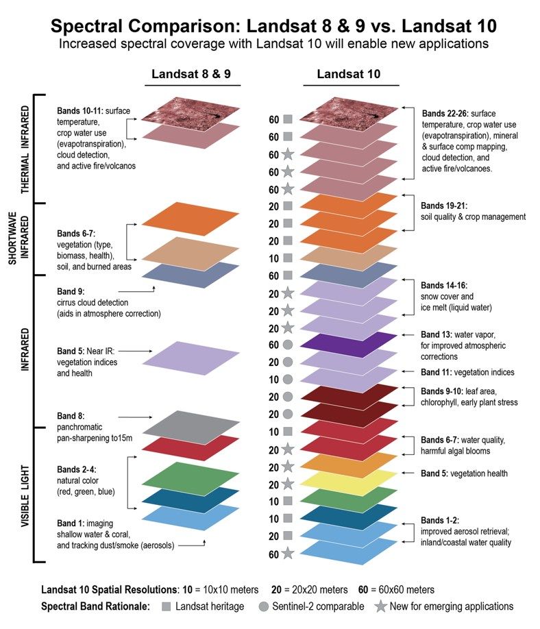
Notable new or enhanced measurements support:
- Harmful algal bloom detection and aquatic ecosystem health (including phycocyanin and chlorophyll indicators).
- Crop residue and non-photosynthetic vegetation mapping for agriculture and soil conservation.
- Vegetation stress, leaf-area index, and health assessment via red-edge and refined near-infrared bands.
- Snow grain size, liquid water content, and albedo for hydrology and cryosphere studies.
- Improved aerosol, water vapor, and cirrus detection for atmospheric correction.
This “superspectral” approach bridges traditional multispectral Landsat observations and higher-resolution hyperspectral systems, delivering greater spectral discrimination while preserving the radiometric stability required for multi-decadal trend analysis.
Finer Spatial Resolution for Greater Detail
Landsat 10 will deliver noticeably sharper imagery than its predecessors. Key resolutions include:
- 10 m ground sample distance for five foundational bands (Blue, Green, Red-2, broad NIR, and SWIR-1).
- 20 m for additional VSWIR bands.
- 60 m for atmospheric VSWIR and all TIR bands.
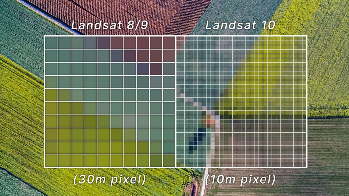
Compared with the 30 m pixels of Landsat 8 and 9, the 10 m bands will resolve smaller landscape features individual agricultural fields, streams, riparian corridors, woodlots, and urban elements with greater clarity. This improvement was informed by user needs surveys and is intended to harmonize more effectively with Sentinel-2 data for integrated analysis.
Geometric performance targets include sub-pixel band-to-band registration and geolocation accuracy better than 8 m after ground correction and terrain compensation for most observations. Radiometric requirements maintain continuity with Landsat 9 when aggregated to 30 m, with stringent absolute accuracy goals (less than 5% in radiance, less than 3% in reflectance for reflective bands, and 1% for TIR at typical Earth temperatures).
Revised section: Why Landsat 10 Matters for Science and Operations
The Landsat archive already underpins land-cover change detection, carbon accounting, drought and wildfire monitoring, water-quality assessment, precision agriculture, urban growth analysis, and climate-impact studies. Landsat 10 strengthens these applications through a combination of finer spatial resolution and expanded spectral coverage.
Here is a clear overview of the main operational and scientific gains:
Water quality & aquatic ecosystems
- New bands for phycocyanin, chlorophyll, and colored dissolved organic matter + refined coastal/aerosol bands.
- Earlier detection of harmful algal blooms, better monitoring of inland and coastal waters.
Agriculture & soils
- 10 m resolution + crop-residue and non-photosynthetic vegetation bands.
- More accurate mapping of tillage practices, residue cover, plant stress, and soil conditions.
Vegetation, forests & ecosystems
Enhanced red-edge and near-infrared bands.
Improved leaf-area index, chlorophyll content, and vegetation-stress indicators.
Snow, ice & hydrology
- Dedicated snow/ice and liquid-water bands + improved thermal measurements.
- Better characterization of snow grain size, albedo, and melt processes for water-resource forecasting
Geology & minerals
- Five thermal infrared bands.
- More reliable surface temperature and emissivity retrieval for mineral mapping.
Cross-mission analysis
- Sentinel-2 complementary bands + simultaneous multi-band acquisition.
- Easier data fusion and more consistent atmospheric correction.
Because Landsat data remain free and openly available, these advances will benefit researchers, commercial analytics providers, government agencies, and non-governmental organizations worldwide. The mission also reinforces Landsat’s role as the radiometric “gold standard” used to calibrate other public and commercial satellite systems.
By delivering superspectral measurements at improved spatial resolution while preserving multi-decadal continuity, Landsat 10 will give the next generation of scientists and decision-makers a sharper, more detailed view of environmental change.
Looking Ahead: Data Continuity in a Changing Earth Observation Landscape
Landsat 10 is not a radical departure but a carefully engineered evolution. It preserves the multi-decadal consistency that makes trend analysis possible while addressing modern requirements for finer detail and spectral specificity. Harmonization with Sentinel-2, advances in cloud computing, and growing use of analysis-ready data and machine learning will amplify its impact.
As the volume of Earth observation data continues to grow, the combination of free, high-quality, well-calibrated Landsat observations with commercial high-resolution and hyperspectral sources will remain powerful. Users of platforms that integrate multi-source satellite imagery whether for environmental monitoring, disaster response, agricultural intelligence, or infrastructure assessment will gain a more detailed and reliable view of change on Earth’s surface.
Landsat 10 is expected to begin operations in the early 2030s, extending a record that already spans more than half a century. By delivering superspectral measurements at improved spatial resolution while upholding the program’s standards of calibration, accessibility, and continuity, it will equip the next generation of scientists and decision-makers with the tools needed to understand and manage a rapidly changing planet.
Key sources for further reading
Official mission details are available from the USGS Landsat Missions page and NASA Science. Spectral band specifications, spatial resolution comparisons, and user-needs documentation provide additional technical depth for analysts planning future workflows.
This mission reinforces why Landsat remains foundational to geospatial intelligence: consistent, trusted measurements that turn decades of observation into actionable insight.
Related articles
- Sentinel-6B Launched: New Climate Sentinel Takes Orbit to Track Accelerating Sea-Level Rise
- Monitoring air quality from space: Sentinel-4 Satellite Delivers First Data on NO2, SO2, and Ozone Levels in Europe
- Sentinel-1D Set for Launch Aboard Ariane 6 on November 4 to Strengthen Europe’s EO Capabilities
- From Maxar to Vantor: A New Era in Satellite Earth Observation and Geospatial Intelligence
- Satellite and Remote Sensing Terms You Should Know