Understanding Satellite Image Resolution: Low vs High Resolution
You often hear about phone resolution when buying a new device - after battery life, it’s usually the first thing you consider. Similarly, the clarity of satellite images - whether they appear crisp and detailed or blurry and pixelated - comes down to one crucial factor: resolution.
In this article, we’ll explore what image resolution means, the types of resolution used in satellite imagery, and when to use each for your geospatial analysis.
What Is Satellite Image Resolution?
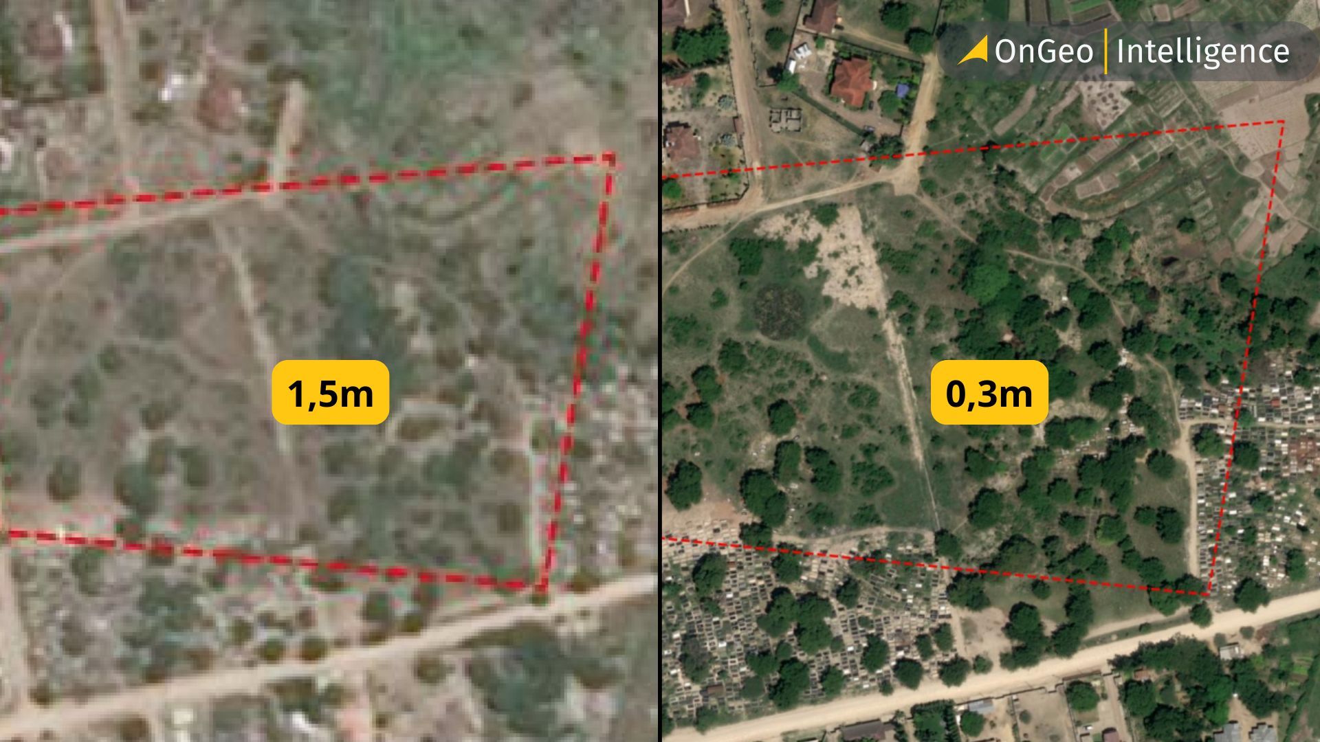
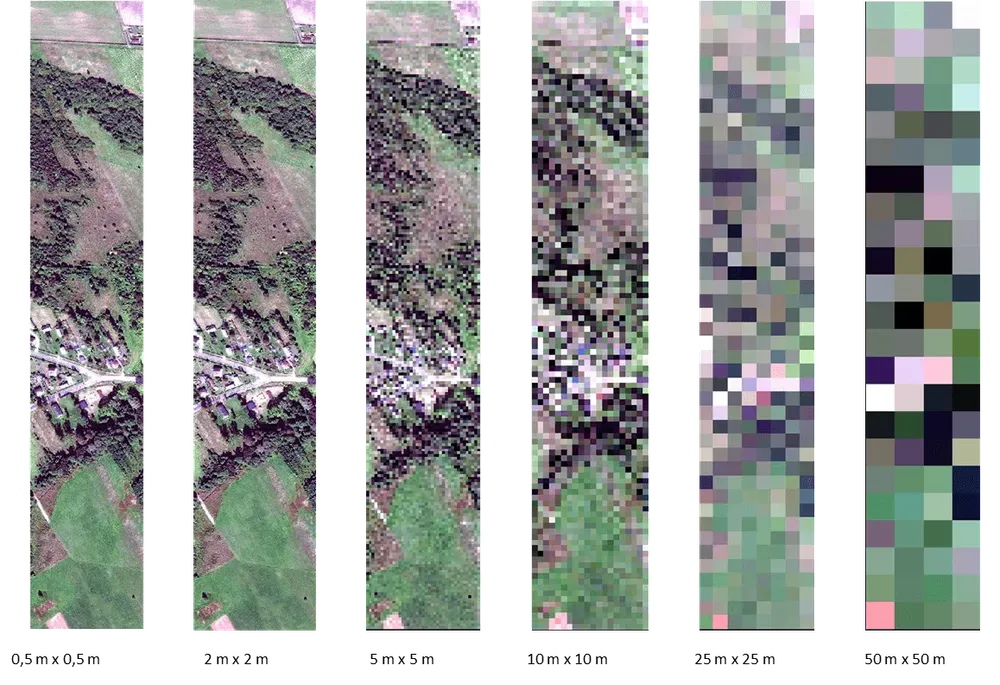
Satellite image resolution refers to the level of detail a satellite sensor can capture from Earth’s surface. It’s often described as the size of the smallest object that can be detected in an image.
For example, if a satellite image has a spatial resolution of 10 meters, each pixel represents an area of 10×10 meters on the ground. A 30-centimeter (0.3 m) image, on the other hand, captures much finer detail - you could distinguish cars, small buildings, or even narrow roads.
There are several types of resolution used in satellite imagery:
- Spatial Resolution – The size of one pixel on the ground (e.g., 10 m, 1 m, 30 cm).
- Spectral Resolution – The number and width of spectral bands the sensor can capture (e.g., visible, infrared, shortwave).
- Temporal Resolution – How often the satellite revisits the same location.
- Radiometric Resolution – The sensor’s ability to detect subtle differences in reflectance or brightness levels.
Together, these factors determine how useful an image is for specific applications - from regional monitoring to precision mapping.
Low vs High Resolution: What’s the Difference?
The main difference between low- and high-resolution satellite imagery lies in how much detail each image can reveal.
Low-resolution imagery (10-1000 m per pixel) is ideal for large-scale analysis - studying climate patterns, tracking deforestation, or monitoring global ocean temperatures. While the details are coarse, it offers a broader perspective of the Earth’s surface. Examples include MODIS (250 m) and Sentinel-3 (300 m).
High-resolution imagery (30 cm–5 m per pixel), on the other hand, provides a close-up view of specific locations. It’s used for urban mapping, infrastructure monitoring, disaster assessment, and military intelligence. Satellites like WorldView-3 (30 cm) or Pleiades Neo (50 cm) can identify vehicles, rooftops, and even small changes in land use.
Here’s a quick comparison:
| Feature: | Low Resolution | High Resolution |
| Pixel size: | 10-1000 m | 0.3-5 m |
| Coverage area: | Global | Regional Local / City level |
| Use case: | Environmental, agricultural, oceanic analysis | Urban planning, construction, defense |
| Data volume: | Small | Large |
| Example satellites: | MODIS, Sentinel-3 | Landsat, WorldView, Pleiades, SkySat |
Why Resolution Matters in Real-World Applications
Choosing the right satellite image resolution isn’t just a technical decision - it determines the accuracy, cost, and usefulness of your analysis.
In urban planning, for example, high-resolution imagery (below 1 meter) allows city planners to identify new roads, rooftops, and informal settlements with precision. Meanwhile, agricultural analysts often use medium-resolution imagery (5–30 meters) from satellites like Sentinel-2 or Landsat 8 to monitor crop health, soil moisture, and irrigation efficiency across entire regions.
In disaster management, resolution can make the difference between detecting a damaged building or missing it entirely. High-resolution imagery provides detailed visual evidence after events like earthquakes, floods, or airstrikes - supporting emergency response and damage assessment.
By contrast, low-resolution imagery plays a vital role in tracking global-scale phenomena like desertification, wildfire smoke movement, or ocean algal blooms-offering a macroscopic view that high-resolution satellites cannot efficiently capture.
In short, the right resolution depends on your goal:
• Global analysis → low or medium resolution
• Local monitoring → high or very-high resolution
Understanding this balance helps geospatial professionals choose the right datasets - saving both time and computational resources while improving accuracy.
How to Choose the Right Resolution for Your Project
Selecting the right satellite image resolution depends on what you want to see and what you need to measure. Higher resolution isn’t always better - it often comes at a higher cost and larger file size, while lower resolution can be more efficient for regional or long-term studies.
Here’s a quick guide to help you decide:
- Project Type: Global Climate Monitoring
- Recommended: 250 m – 1 km (Low)
- Example Satellites: MODIS, VIIRS
- Purpose / Use Case: Large-scale environmental trends, temperature, and cloud movement
- Project Type: Agriculture & Forestry
- Recommended: 5 – 30 m (Medium)
- Example Satellites: Landsat 8/9, Sentinel-2
- Purpose / Use Case: Crop health, vegetation indices (NDVI), deforestation tracking
- Project Type: Urban Mapping & Infrastructure
- Recommended: 0.3 – 5 m (High)
- Example Satellites: WorldView, Pleiades, PlanetScope
- Purpose / Use Case: Building footprints, road networks, land use
- Project Type: Disaster Response & Intelligence
- Recommended: <1 m (Very High)
- Example Satellites: Maxar, Airbus
- Purpose / Use Case: Damage assessment, conflict monitoring, search and rescue
- Project Type: Hydrology & Coastal Studies
- Recommended: 10 – 30 m (Medium)
- Example Satellites: Sentinel-2, Landsat
- Purpose / Use Case: Water quality, sediment plumes, flood mapping
Key Considerations:
- Budget: High-resolution commercial data can be costly, while free sources (Sentinel, Landsat) offer excellent medium-resolution coverage.
- Frequency: Some satellites provide daily coverage at low resolution but only weekly or monthly at high resolution.
- Processing Power: Higher resolution means larger datasets - ensure you have the tools or cloud platforms to handle them efficiently (e.g., Google Earth Engine or OnGeo tools).
Choosing wisely helps balance clarity, cost, and computation - ensuring your geospatial insights are both powerful and practical.
What People Often Get Wrong About Satellite Image Resolution
Despite its importance, satellite image resolution is one of the most misunderstood concepts in remote sensing. Here are a few common misconceptions to watch out for:
- Higher resolution doesn’t always mean better results
Many assume that the sharper the image, the more useful it is - but that’s not always true.
High-resolution data can be expensive, require larger storage, and take longer to process. For large-scale environmental studies, lower-resolution imagery can actually be more efficient and scientifically valid. - Confusing spatial resolution with image quality
A crisp-looking image doesn’t automatically mean it has high spatial resolution.
Cloud cover, atmospheric distortion, and lighting conditions can make a high-resolution image appear poor, while a medium-resolution image can still be scientifically valuable. - Overlooking temporal and spectral resolution
People often focus only on spatial detail, forgetting that the time frequency (how often a satellite revisits an area) and spectral bands (the wavelengths it captures) are equally important.
For example, Sentinel-2 may have lower spatial resolution than WorldView-3, but its spectral range and free access make it ideal for many environmental applications. - Using the wrong resolution for the wrong purpose
A common mistake is using high-resolution imagery for broad regional mapping or low-resolution imagery for city-scale planning.
Choosing the wrong resolution can waste both money and computational resources, while reducing the accuracy of your analysis.
OnGeo’s Role in Delivering Multi-Resolution Insights
At OnGeo Intelligence, satellite resolution isn’t just a technical metric - it’s the foundation for meaningful, actionable insight. The platform integrates imagery from multiple satellite sources, enabling users to access and analyze both high-resolution and low-resolution data in one place.
Whether you’re exploring a global environmental trend or zooming in to assess damage after a disaster, OnGeo provides the flexibility to switch between resolutions effortlessly.
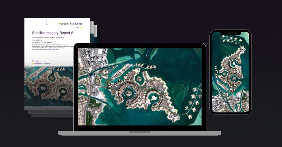
See sample Satellite Imagery Report
Read More Here: Satellite Imagery Report
Here’s how OnGeo adds value:
- Multi-Resolution Integration: Combines imagery from sensors like Sentinel-2, and WorldView, giving users the ability to view and compare scenes across scales.
- Automatic Updates: Continuously refreshes imagery to reflect the most recent data, ensuring users always have the latest view of changing landscapes.
- Analytics-Ready Data: Pre-processed imagery minimizes technical barriers, allowing professionals and analysts to focus on insights rather than data cleaning.
- AI-Driven Detection: OnGeo’s tools leverage machine learning to identify land use changes, infrastructure growth, or environmental degradation automatically.
By bridging the gap between raw satellite data and ready-to-use intelligence, OnGeo empowers decision-makers - from urban planners to researchers - to make informed choices, faster.
Summary: Understanding Satellite Image Resolution is Important
Understanding satellite image resolution is more than just knowing how sharp an image looks - it’s about knowing what kind of story the data can tell.
From monitoring crops and cities to tracking climate change, each level of resolution serves a unique purpose in helping us understand our planet.
In 2025 and beyond, as satellites become more advanced and accessible, the ability to choose the right resolution will be key for anyone working in geospatial intelligence, research, or environmental monitoring.
Platforms like OnGeo Intelligence make this process simpler - connecting users to the right data, at the right scale, for the right decision.
In the end, whether low or high, every image helps piece together the bigger picture of Earth - one pixel at a time.
Related articles
- How Satellite Imagery Works: From Space to Your Screen
- Satellite and Remote Sensing Terms You Should Know
- What Is Satellite Imagery? A Complete Beginner’s Guide
- Satellite Imagery vs Aerial Photography: Key Differences Explained
- Understanding DEM, DTM and DSM in Satellite Earth Observation
- How to Download High-Resolution Satellite Images