Liulan Reservoir and Dam & Yunbiao Reservoir: Two Critical Water Infrastructure Projects Hit by China's Devastating 2026 Floods
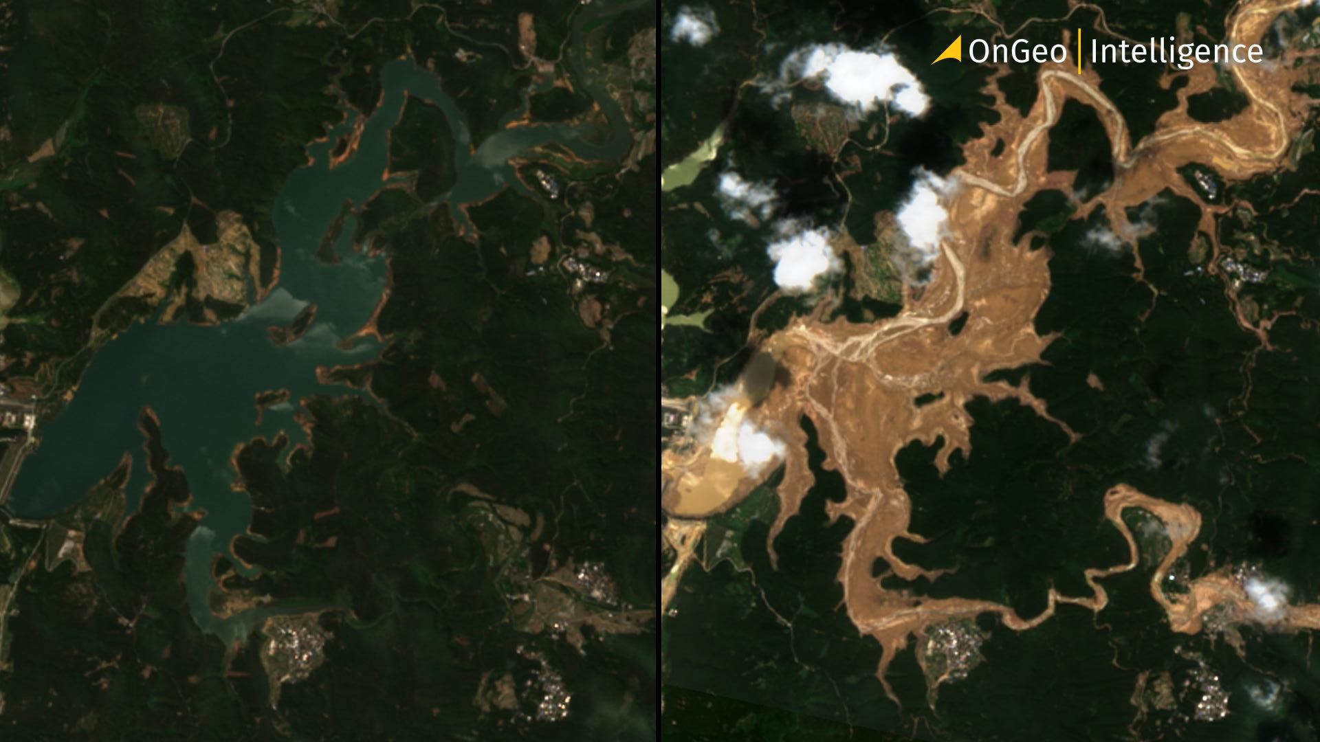
Liulan Reservoir and Dam & Yunbiao Reservoir failed dramatically on July 6, 2026, sending torrents of floodwater into downstream villages and contributing to one of the deadliest flood events in the region in recent memory.
The reservoirs of Liulan and Yunbiao have become the focus of national and international attention after unprecedented rainfall triggered by Typhoon Maysak caused one of the most serious water infrastructure emergencies in southern China in recent years. While the Liulan Reservoir Dam suffered a catastrophic breach that unleashed destructive floodwaters downstream, the nearby Yunbiao Reservoir also entered a state of emergency as authorities fought to prevent further disaster across Hengzhou City.

Liulan Reservoir and Dam & Yunbiao Reservoir
The two reservoirs are among the most important pieces of water infrastructure in Hengzhou, a county-level city administered by Nanning in the Guangxi Zhuang Autonomous Region. Built during China's large-scale water conservancy campaign of the late 1950s, both projects have supported agriculture, flood control and local economic development for decades. Their strategic importance became painfully clear in July 2026, when days of relentless rainfall overwhelmed rivers, reservoirs and drainage systems throughout the region, forcing tens of thousands of people from their homes.
Although the dramatic images of the Liulan Dam breach captured global attention, emergency managers were simultaneously dealing with dangerous conditions at Yunbiao Reservoir, making the event a broader regional water crisis rather than a single dam failure.
Liulan Reservoir: A Key Water Source for Hengzhou
Liulan Reservoir is located in Liulan Village, Xiaoyi Township, approximately 33 kilometers northeast of downtown Hengzhou City. The reservoir lies on the Yunbiao River, a tributary of the Yu River, and has served as one of the region's principal water management projects for more than six decades.
Over time, Liulan Reservoir evolved into a comprehensive water resource project. Besides supplying irrigation water for agricultural production, it became an important source of drinking water, supported fish farming, generated hydroelectric power and played a crucial role in controlling seasonal floods that regularly affect Guangxi Province.
Today, the reservoir serves 46 village committees and 136 natural villages across the townships of Xiaoyi, Yunbiao, Maling and Hengzhou. Around 170,000 residents depend directly or indirectly on the reservoir for their livelihoods, while its irrigation network supports approximately 15,730 hectares of farmland, making it one of the most important agricultural water sources in the region.
Dam breach during Typhoon Maysak
Extreme rainfall generated by Typhoon Maysak overwhelmed the reservoir in early July 2026. On 6 July, sections of the earth-rock dam failed, releasing massive floodwaters downstream. Entire villages were rapidly inundated.
Effects of flooding: destroyed roads, cut electricity, interrupted telecommunications, trapped residents on rooftops, buried homes beneath mud and debris.
Emergency authorities immediately raised Hengzhou's flood response to Level I, China's highest emergency level.
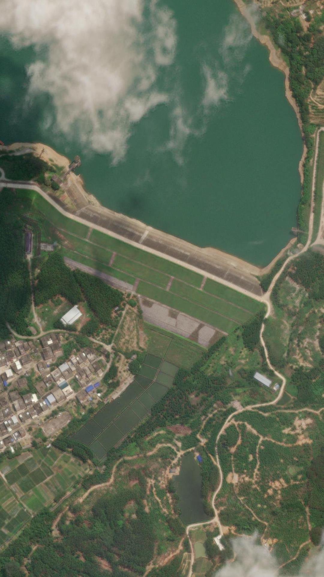
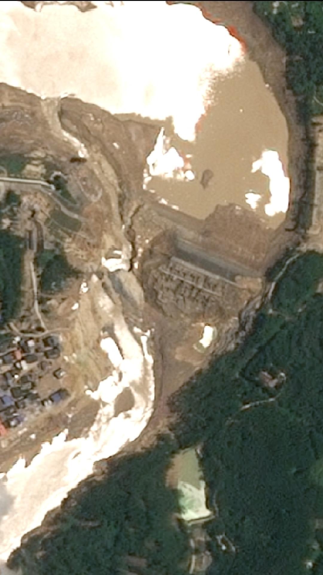
View the full satellite imagery report
Yunbiao Reservoir: Another Pillar of Regional Water Management
Only a short distance from Liulan lies the Yunbiao Reservoir, another medium-sized water storage project that has played a fundamental role in regional agriculture since the late 1950s.
Located in Shankou Village, Yunbiao Township, the reservoir was jointly constructed by the former Gui County and Heng County, reflecting the scale of cooperation required to develop irrigation infrastructure across the region during that period.
The project eventually included a 36-meter-high dam with a crest length of approximately 340 meters. Its water system was connected to an extensive irrigation network consisting of a 45-kilometer main canal and nearly 60 kilometers of branch canals, allowing water to reach farmland across multiple townships.
Although considerably smaller than Liulan Reservoir, it remains one of Hengzhou's most important irrigation projects, supplying water to tens of thousands of hectares of farmland.
Emergency Conditions at Yunbiao Reservoir
When Typhoon Maysak struck Guangxi, Yunbiao Reservoir also entered a dangerous phase.
Although it did not experience the catastrophic structural collapse seen at Liulan Reservoir, authorities reported emergency conditions caused by rapidly rising water levels and exceptional inflows.
Officials warned of overtopping risks and initiated emergency flood-control procedures designed to reduce pressure on the reservoir. At the same time, downstream residents were ordered to prepare for possible evacuation as emergency planners assessed the rapidly changing situation.
Yunbiao Reservoir became one of several major reservoirs included in Hengzhou City's highest-level flood emergency response. Authorities coordinated reservoir management across the region to minimize downstream flooding while balancing the need to protect dam safety.
Because Liulan and Yunbiao operate within the same regional water system, decisions affecting one reservoir inevitably influenced emergency planning for the other.
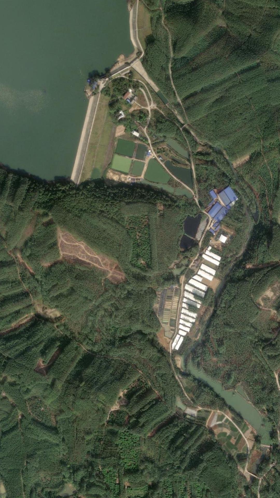
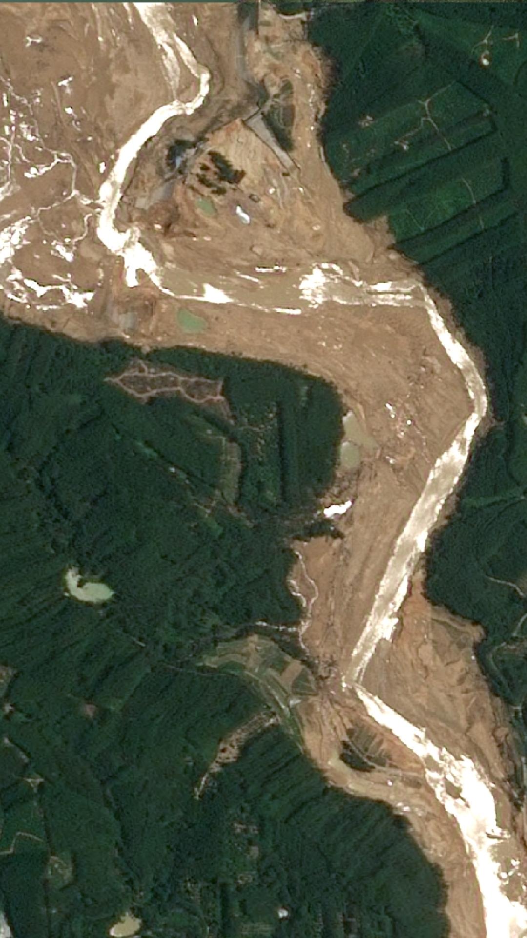
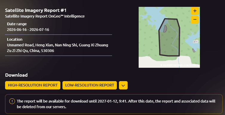
View the full satellite imagery report
One of Guangxi's Largest Rescue Operations
The flooding triggered an enormous emergency response involving local, provincial and national rescue agencies.
China Anneng Group mobilized 350 specialist personnel, including experts in hydrology, geology and disaster assessment. The teams arrived from Beijing, Guangxi, Guizhou, Hunan and Yunnan, bringing more than 130 pieces of specialized equipment ranging from communication systems to road-clearing machinery and high-capacity drainage pumps.
Meanwhile, Guangxi's Fire and Rescue Department dispatched 620 firefighters, supported by 152 emergency vehicles and 70 rescue boats. Inflatable boats transported trapped residents from flooded villages while helicopters and drones assisted in aerial assessments of the disaster zone.
Emergency communication companies deployed satellite phones, portable power generators and communication vehicles after conventional mobile networks failed in several communities.
By the evening of 6 July, firefighters alone had evacuated more than 710 people from the areas surrounding Liulan Reservoir. Many elderly residents required stretcher evacuations or had to be carried to safety on the backs of rescue workers before receiving medical treatment at temporary field stations.
The Role of Satellite Imagery in Assessing the Disaster
Satellite imagery has become one of the most valuable tools for monitoring natural disasters such as the flooding that affected the Liulan Reservoir Dam and Yunbiao Reservoir. High-resolution satellite imagery Earth observation data allows authorities, engineers and emergency responders to assess rapidly changing conditions, even when floodwaters make ground access impossible.
During events like the July 2026 floods in Guangxi, satellite imagery helps emergency teams quickly understand the scale of the disaster and supports decision-making throughout both the response and recovery phases.
Satellite imagery from OnGeo Intelligence can be used to:
- Monitor dam conditions before and after extreme weather events.
- Detect flooded areas and measure the extent of inundation.
- Compare pre- and post-disaster imagery to identify damaged infrastructure.
- Track changes in reservoir water levels and surrounding landscapes.
- Support emergency response teams by identifying inaccessible roads and isolated communities.
- Assess damage to critical infrastructure, including bridges, roads and hydrological facilities.
- Provide geospatial data for disaster assessment, insurance claims and reconstruction planning.
By combining high-resolution satellite imagery OnGeo Intelligence delivers actionable insights that help governments, humanitarian organizations, insurers and infrastructure operators better understand the impact of natural disasters. Near real-time satellite data enables faster damage assessments, improves situational awareness and supports more informed decisions during rescue operations, recovery efforts and long-term infrastructure resilience planning.
Human and Economic Consequences
The scale of the disaster extended far beyond damaged infrastructure.
Initial government estimates indicated that approximately 55,000 people across the Nanning region had been affected by flooding linked to the reservoir emergencies. Around 48,000 residents were evacuated as floodwaters spread through Hengzhou and neighboring areas.
Agriculture suffered severe losses. Livestock farms, timber factories and cropland disappeared beneath floodwaters within hours. One local farmer reported that floodwaters destroyed his timber processing business and washed away approximately 16,000 pigs, resulting in estimated losses exceeding 50 million yuan.
Roads, bridges and utility infrastructure also sustained extensive damage. Several hydrological monitoring stations near Liulan Reservoir were rendered inoperable after floodwaters hollowed out their foundations, complicating ongoing flood monitoring efforts.
Summary Critical Floods
The emergencies at Liulan Reservoir Dam and Yunbiao Reservoir highlight the critical importance of resilient water infrastructure in the face of increasingly extreme weather. Triggered by Typhoon Maysak, the July 2026 floods caused widespread damage, mass evacuations and an unprecedented rescue effort across Hengzhou. As recovery continues, the disaster underscores the growing role of modern monitoring technologies, including high-resolution satellite imagery from OnGeo Intelligence, in supporting rapid damage assessment, emergency response and future infrastructure planning.
Related articles
- Massive Oil Spill Off Kharg Island, Iran: Satellite Imagery Reveals Environmental Crisis in the Persian Gulf
- Mining Operations Monitoring via Satellite Imagery
- Satellite Images Reveal the Devastating Scale of Venezuela’s Twin Earthquakes
- Satellite Imagery for Disaster Response and Recovery
- Super Typhoon Ragasa: Satellite Imagery Reveals Devastation Across Taiwan and Hong Kong
- Landslide in Blatten, Switzerland: A Satellite Imagery Analysis
- Satellite images reveal devastating floods in Poland