Mining Operations Monitoring via Satellite Imagery
Mining operations are dynamic and often cover vast, remote areas, making consistent monitoring a challenge. Satellite imagery provides an efficient way to observe mining activities over time, enabling the tracking of extraction progress, infrastructure changes, and environmental impacts. This article examines how satellite-based monitoring supports effective, responsible, and transparent management of mining operations.
How Satellite Imagery Is Used in Mining Operations
Satellite imagery is widely used in mining operations to monitor surface changes associated with extraction activities. Because mining sites evolve continuously, satellite data provides a consistent way to observe operational developments over time without relying solely on ground inspections.
By analyzing satellite images, stakeholders can identify excavation areas, track the expansion of open pits, and monitor the development of supporting infrastructure such as access roads, processing facilities, and waste storage areas.
Satellite imagery supports mining operations by enabling:
- Tracking of mine expansion and land disturbance
- Monitoring infrastructure development and access routes
- Identifying changes in stockpiles, tailings, and waste areas
- Detecting unauthorized or unreported mining activity
Both optical and radar satellite data are used depending on conditions. Optical imagery provides detailed visual information, while radar data supports monitoring in areas with frequent cloud cover or challenging weather conditions.
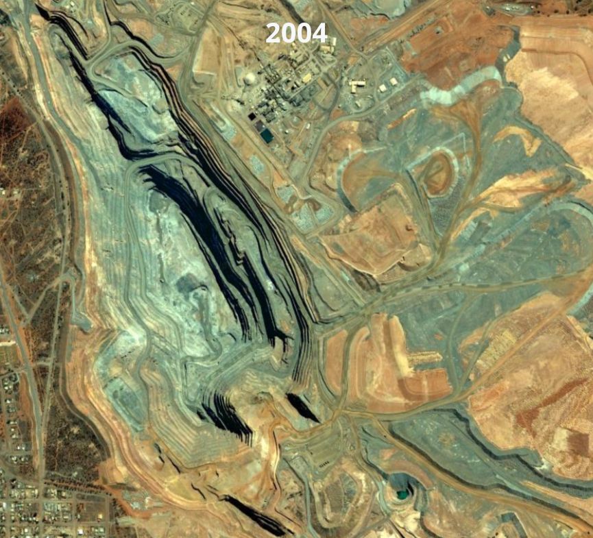
Gudai-Darri an iron ore mine in Western Australia
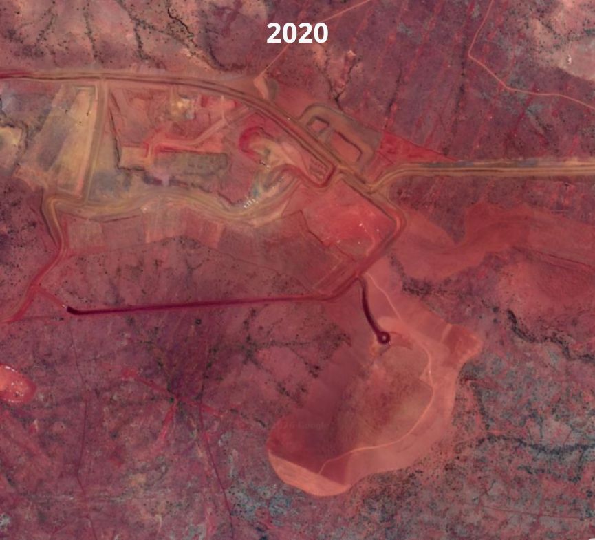
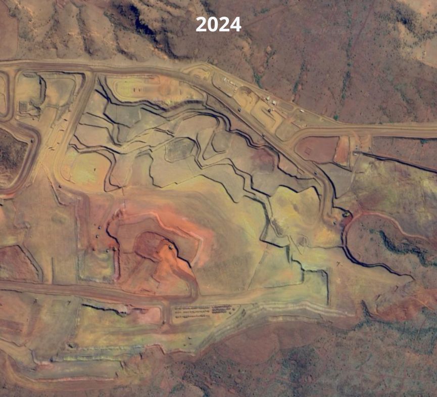
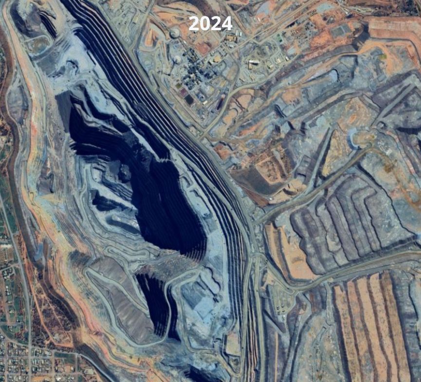
Monitoring Mine Expansion and Extraction Activity
Monitoring the expansion of mining sites is one of the most common applications of satellite imagery in the mining sector. As extraction progresses, visible surface changes such as the growth of open pits, new excavation zones, and increased material movement can be detected through repeated satellite observations.
By comparing satellite images captured over time, analysts can measure the rate and direction of mine expansion. This time-series analysis helps quantify land disturbance, track operational intensity, and verify whether reported mining activity aligns with observed site development.
Satellite imagery enables:
- Identification of newly excavated areas
- Measurement of pit growth and surface disturbance
- Monitoring of changes in material stockpiles
- Detection of operational slowdowns or accelerations
This continuous monitoring provides an objective record of extraction activity, supporting operational oversight, compliance verification, and long-term planning.
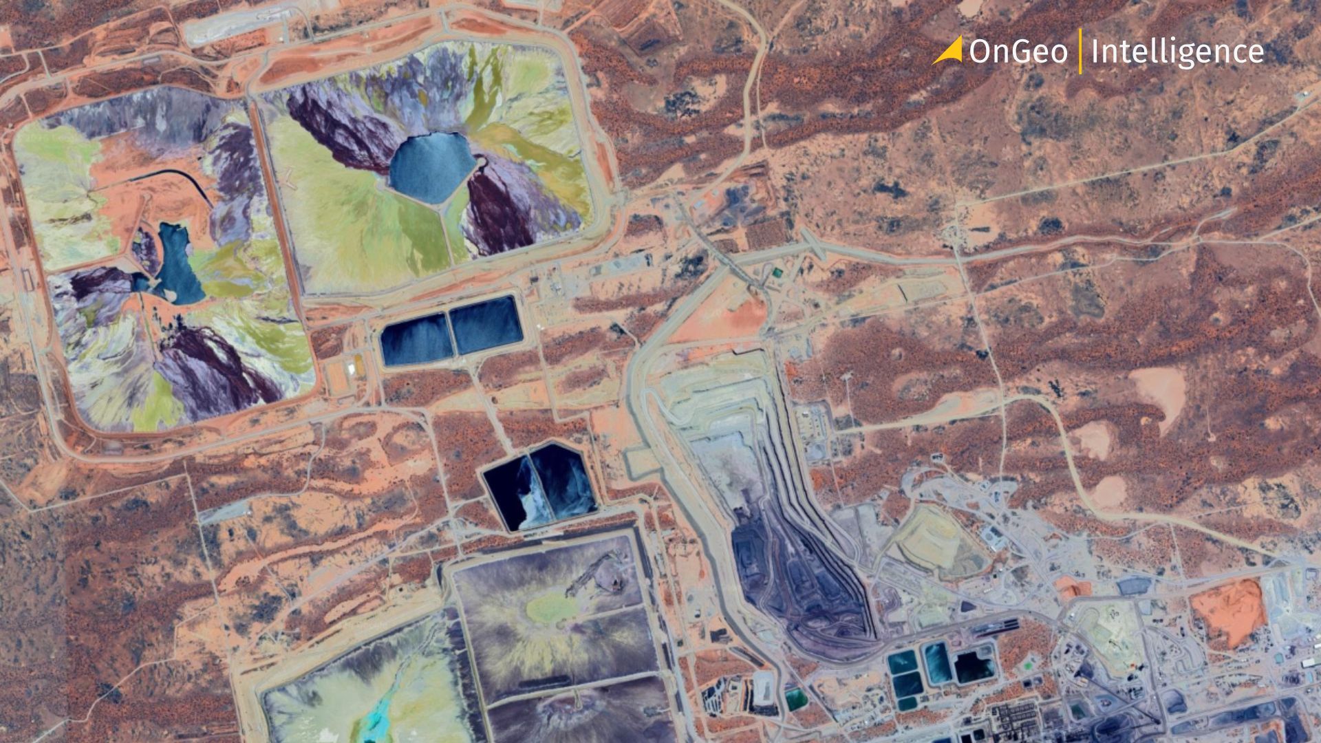
Tailings, Waste, and Environmental Impact Monitoring
Satellite imagery plays an important role in monitoring tailings ponds, waste rock piles, and other environmental impacts associated with mining. Changes in the size, shape, or appearance of these features can reveal operational shifts and potential risks such as leakage, erosion, or uncontrolled runoff.
Using time-series analysis, satellite data helps stakeholders monitor tailings storage facilities, assess land degradation and vegetation loss, detect unusual discharges, and verify compliance with environmental regulations.
Advanced technologies further enhance monitoring capabilities. InSAR (Interferometric Synthetic Aperture Radar) can detect millimeter-scale ground movements in tailings dams and waste piles, providing early warning signs of potential instability before visible damage occurs. This allows operators to take preventive action and reduce the risk of failures.
Multispectral satellite imagery can also identify environmental changes linked to acid mine drainage or heavy metal contamination by detecting subtle variations in soil and water conditions. Combined with frequent observations, these datasets create a transparent and reliable record of a site's environmental performance, supporting responsible resource management and stronger ESG (Environmental, Social, and Governance) practices.
The Fimiston open mine in Western Australia
Detecting Illegal or Unregulated Mining
Satellite imagery is a valuable tool for detecting illegal or unregulated mining, particularly in remote areas where on-site monitoring is difficult. High-resolution imagery and change detection techniques can identify signs of unauthorized activity, including new clearings, access roads, excavation sites, and sediment plumes in nearby waterways.
Radar satellites (SAR) further enhance monitoring by providing reliable observations regardless of cloud cover, smoke, or lighting conditions. Combined with historical imagery, satellite data enables authorities to detect changes early, track the expansion of illegal operations, and support more effective enforcement and environmental protection efforts.
How OnGeo Intelligence Supports Mining Monitoring Workflows
OnGeo Intelligence simplifies mining monitoring by providing easy access to satellite imagery and tools for tracking changes over time without requiring advanced GIS software.
The platform enables users to:
- Access recent and historical satellite imagery of mine sites
- Compare before-and-after images to detect changes in operations or site expansion
- Monitor tailings, stockpiles, and waste areas for environmental assessment
- Document site activity for reporting, auditing, and compliance purposes
OnGeo Intelligence supports more efficient monitoring, better decision-making, and more responsible resource management for mining stakeholders.
Why Satellite Monitoring Matters for Mining Operations
As mining operations face growing expectations around environmental performance, safety, and regulatory compliance, satellite monitoring provides a reliable and objective way to observe activities across large and remote sites.
By tracking operational and environmental changes over time, satellite imagery helps stakeholders:
- Ensure compliance with environmental and safety regulations
- Detect unauthorized or illegal mining activities
- Support transparent reporting and auditing
- Improve operational planning and risk management
Beyond compliance, satellite data supports more efficient resource management. Regular monitoring of stockpiles, waste deposits, and site development enables better planning, reduces the need for costly field surveys, and helps optimize operational processes.
Satellite imagery also plays a key role in ESG reporting by creating a consistent, verifiable record of a mine's lifecycle from active extraction to land rehabilitation. This transparency helps mining companies demonstrate environmental responsibility, strengthen stakeholder trust, and support more sustainable mining practices.
Factors to Consider When Using Satellite Imagery for Mining Monitoring
The effectiveness of satellite-based mining monitoring depends on several key factors. Choosing the right data and monitoring approach ensures accurate and reliable insights.
Image Resolution – Higher-resolution imagery provides greater detail for monitoring features such as stockpiles, tailings facilities, and infrastructure, but may involve higher acquisition costs.
Revisit Frequency – The frequency of satellite observations determines how quickly operational or environmental changes can be detected.
Weather Conditions – Optical imagery can be affected by clouds, dust, and smoke. In challenging conditions, radar data offers a reliable alternative.
Historical Data Access – Archived imagery enables baseline creation, long-term trend analysis, and assessment of environmental or operational changes over time.
Regulatory Requirements – Monitoring programs should align with local environmental, safety, and reporting regulations to support compliance and documentation needs.
By considering these factors, mining operators can maximize the value of satellite imagery and develop more effective monitoring strategies.
The Value of Satellite Intelligence in Mining Operations
Satellite imagery has become an essential tool for monitoring mining operations, offering a consistent and objective view of site activity, infrastructure development, and environmental impact. It enables stakeholders to track changes, support compliance efforts, and improve operational decision-making.
Platforms like OnGeo Intelligence make satellite data more accessible by transforming imagery into actionable insights for mining companies, regulators, and environmental organizations. As satellite technologies continue to evolve, they will play an increasingly important role in improving transparency, efficiency, safety, and sustainability across the mining sector.
Related articles
- Where to Find Satellite Imagery from a Specific Period? Explore OnGeo Intelligence Archives!
- Detection of Illegal Construction in Satellite Images
- Construction Site Monitoring with Satellite Images
- How to Download High-Resolution Satellite Images
- Satellite Imagery: Definition and Applications in 2026
- Satellite Imagery for Disaster Response and Recovery