
GEO vs LEO Satellite Orbits, Altitude, Latency and Applications
Satellite design begins with a fundamental constraint: the altitude at which a spacecraft will operate. That single parameter shapes nearly every subsequent engineering decision coverage: geometry, signal delay, power requirements, constellation scale, radiation exposure, and end-of-life strategy. Two regimes dominate practical discussion: geostationary orbit (GEO) and low Earth orbit (LEO). Their differences are not incremental; they reflect distinct solutions to the same set of orbital mechanics equations.

The Physics That Sets the Rules
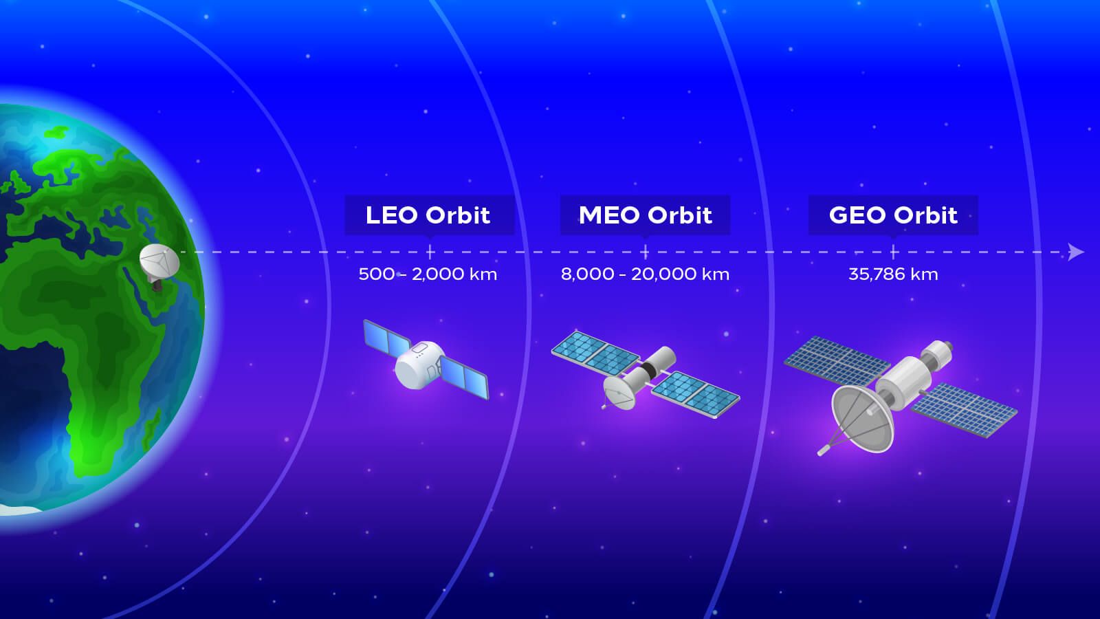
Orbital period is governed by Kepler’s third law, while gravitational force decreases with the square of distance from Earth’s center. Closer to Earth, a satellite must travel faster to remain in continuous free fall; farther out, velocity decreases and the period lengthens. At approximately 35,786 km above the equator the period matches Earth’s sidereal day, producing the stationary appearance that defines GEO. Between roughly 160 km and 2,000 km the period shrinks to 90–120 minutes, producing the rapid ground tracks of LEO.
Signal propagation time scales directly with distance. Path loss grows with the square of range, so higher orbits demand more powerful transmitters or larger antennas. Atmospheric drag, negligible at GEO altitudes, becomes a limiting factor in the lower reaches of LEO and ultimately dictates natural decay timescales.
Geostationary Platforms Persistent Footprint and Fixed Geometry
A satellite in true geostationary orbit remains fixed relative to a ground observer. This property eliminates the need for tracking antennas and enables continuous observation of the same geographic region. A single spacecraft can illuminate approximately one-third of Earth’s disk; three equally spaced platforms deliver near-global coverage outside the polar zones.
The same geometry that provides persistence also imposes latency. Round-trip radio travel times routinely exceed 500 ms (milliseconds), rendering GEO unsuitable for highly interactive applications while remaining entirely acceptable for broadcast distribution and meteorological staring. Long operational lifetimes frequently 15 years or more are typical because atmospheric drag is essentially absent. Retired satellites are usually raised into a dedicated graveyard orbit rather than deorbited.
Low Earth Platforms Speed, Density, and Rapid Revisit
LEO satellites complete an orbit in roughly 90 minutes and remain visible from any fixed location for only a few minutes. Continuous service therefore requires large constellations that hand traffic between successive spacecraft. Modern broadband systems exploit this regime precisely because the short range yields low latency often comparable to terrestrial networks under good conditions and because proximity improves imaging resolution for a given optical aperture.
The International Space Station itself operates in LEO, typically near 400 km. Contemporary commercial constellations occupy shells ranging from roughly 330 km to 570 km, with progressive migration toward lower altitudes to further reduce latency and accelerate natural deorbiting at end of life. The resulting population density is high: the majority of active satellites now reside in LEO.
Trade-Off Matrix Coverage, Latency, and Scale
| Characteristic | Geostationary (GEO) | Low Earth Orbit (LEO) |
|---|---|---|
| Altitude | 35,786 km | 160–2,000 km |
| Ground-relative motion | Essentially stationary | Rapid (minutes of visibility) |
| Coverage per satellite | ~1/3 of Earth | Limited footprint |
| Satellites for global service | 3–5 | Thousands |
| Typical round-trip latency | 500+ ms | Tens of ms |
| Antenna requirements | Fixed pointing | Tracking or phased-array |
| Key uses | Broadcast, continuous weather, TV, comms | Broadband, high-resolution imaging, ISS |
| Example satellites / missions | GOES-16, Meteosat-11 | Landsat 8/9, Sentinel-2, ISS, Starlink |
No regime is universally superior. Persistent regional monitoring and one-to-many distribution favor GEO. Interactive connectivity and fine-scale Earth observation favor LEO.
Medium Earth Orbit as a Deliberate Compromise
Between the two extremes lies medium Earth orbit (MEO), roughly 2,000–35,500 km. Global navigation systems occupy a well-defined band within this region: GPS near 20,200 km and Galileo near 23,222 km. At these altitudes a constellation of a few dozen satellites can maintain continuous global coverage while keeping latency far below GEO values. The orbital periods produce repeating ground tracks that simplify system design and orbital determination.
Operational Implications Across Everyday Services
Continuous satellite imagery used in hurricane tracking almost invariably originates from geostationary sensors that never lose sight of the storm. Consumer broadband delivered through a flat-panel terminal is the product of a dense, rapidly moving LEO fleet. Background positioning calculations performed by smartphones rely on MEO navigation signals. Each service has selected the orbital regime whose physical properties best match its functional requirements.
Polar coverage remains a special case. Equatorial GEO satellites view high latitudes at extreme angles; individual LEO passes are brief. Sun-synchronous polar orbits and specialized highly elliptical trajectories address these gaps by design.
Longevity, Debris, and System Design Choices
Atmospheric drag in lower LEO altitudes guarantees eventual re-entry, a feature deliberately used by some operators to limit long-term debris. GEO satellites, free of significant drag, require active disposal into graveyard orbits. Radiation environments also differ: LEO spacecraft benefit from partial shielding by Earth’s magnetic field, while higher orbits experience more intense exposure over multi-year missions.
How to Choose the Right Orbit for a Mission?
Choosing the right orbital regime depends on the mission’s primary requirements: coverage, latency, resolution, revisit frequency, constellation size, and operational lifetime. There is no single orbit that is optimal for every application.
- Choose LEO when low latency, high-resolution Earth observation, or frequent revisit is the priority. LEO is widely used for broadband constellations, imaging satellites, and scientific missions.
- Choose MEO when broad coverage and moderate latency are required. Navigation and positioning systems such as GPS and Galileo operate in MEO because satellites can cover large areas while maintaining lower latency than GEO.
- Choose GEO when continuous observation or persistent regional coverage is essential. GEO is particularly effective for weather monitoring, satellite broadcasting, and other services that benefit from a fixed view of the same area.
Ultimately, orbit selection is a mission-architecture decision. The optimal regime balances performance requirements with spacecraft complexity, constellation size, launch costs, radiation exposure, and end-of-life considerations.
Frequently Asked Questions About Satellite Orbits
What is the difference between LEO and GEO?
LEO satellites orbit much closer to Earth, typically between 160 and 2,000 km, providing lower latency and high-resolution observation. GEO satellites orbit at 35,786 km and remain fixed relative to a point on the equator, making them ideal for continuous coverage and broadcasting.
Which is better: LEO or GEO?
Neither orbit is universally better. LEO is better for low-latency communications, broadband, and high-resolution Earth observation, while GEO is better for persistent regional coverage, weather monitoring, and broadcasting.
Why do LEO satellite constellations need so many satellites?
LEO satellites move rapidly across the sky and remain visible from a given location for only a short period. Large constellations allow continuous service by handing connections from one satellite to another.
Is GPS in LEO or GEO?
GPS satellites operate in Medium Earth Orbit (MEO), at an altitude of approximately 20,200 km. MEO provides broad coverage while maintaining lower latency than GEO.
Which orbit is best for Earth observation?
LEO is generally preferred for high-resolution Earth observation because satellites are much closer to the surface. The shorter distance allows detailed imaging with relatively compact optical systems.
How does orbital altitude affect satellite latency?
Higher orbital altitude means a longer signal path and therefore greater communication delay. GEO systems typically have round-trip latency above 500 ms, while LEO systems can achieve latency in the tens of milliseconds.