Satellite Imagery Reveals the Scale of Destruction Across Southern Lebanon
The ceasefire between Israel and Hezbollah, agreed in mid-April 2026, remains tenuously in place. Yet high-resolution and medium-resolution satellite imagery reveals a stark reality on the ground: systematic large-scale demolitions continue across southern Lebanon, particularly within the IDF-designated “Yellow Line” zone.
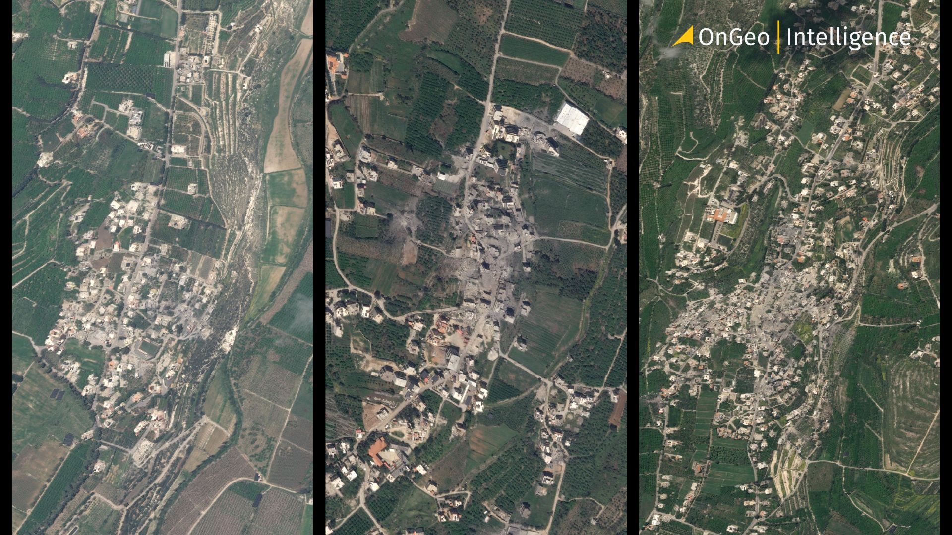
Analysis imagery from captured on March and May 2026, shows that at least 46 of 54 towns and villages within this border-adjacent area have suffered heavy damage or complete flattening in the past two months.
A Fragile Ceasefire Overshadowed by Expanding Demolitions
Southern Lebanon is facing one of the most dramatic periods in its recent history. Although the ceasefire between Israel and Hezbollah announced in April 2026 has largely held, satellite imagery shows that destruction across the border region has continued at an alarming pace.
Recent analysis based on PlanetScope imagery reveals widespread devastation in dozens of towns and villages near the Israeli border. Entire residential districts, roads, and public infrastructure have disappeared within weeks. What makes this situation particularly striking is that much of the destruction appears to have occurred after the ceasefire agreement was announced.
The images expose a humanitarian crisis unfolding almost in real time one that can now be observed directly from space.
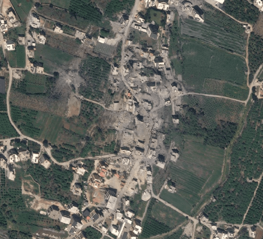
Entire Villages Are Disappearing
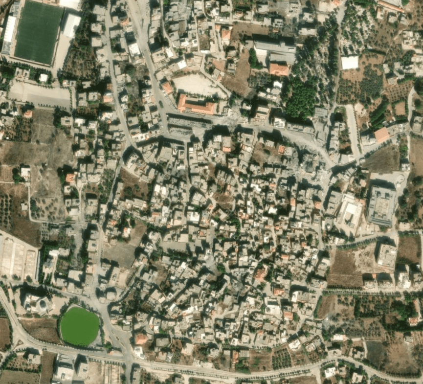
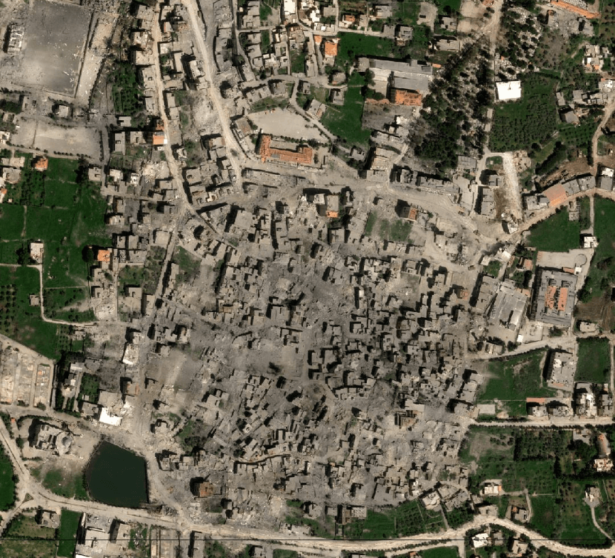
Satellite comparisons between March and May 2026 reveal how quickly southern Lebanon’s landscape has changed. Towns that once contained dense residential neighborhoods now appear as large grey fields of rubble and dust.
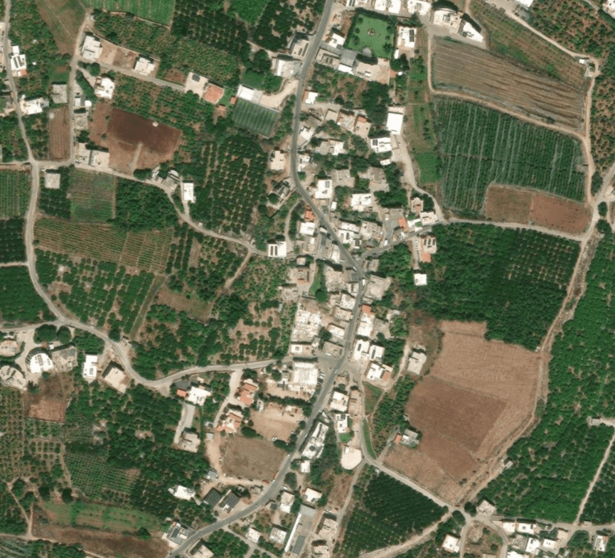
Some of the heaviest destruction is visible in communities such as Naqoura, Kfar Kila, Qantara, Aadashit, Yaroun, and Bint Jbeil. In several locations, entire sections of villages appear flattened.
Analysts studying the imagery note that the patterns of destruction suggest a combination of airstrikes and controlled demolitions using explosives and heavy construction equipment. Videos published online by the Israeli military have shown demolitions taking place in multiple villages, while footage circulating on social media documents the aftermath left behind.
One of the most widely discussed incidents occurred in the village of Qantara, where the Israeli military stated it had destroyed tunnel systems allegedly built by Hezbollah. According to official statements, hundreds of tonnes of explosives were used during the operation. Satellite imagery captured afterward showed major parts of the village erased.
Nearby Aadashit suffered similar damage. Imagery from late April revealed large demolition zones surrounding buildings identified by the Israeli military as Hezbollah infrastructure.
Before-and-after satellite imagery of Bint Jbeil, Lebanon, revealing extensive destruction and large-scale damage across residential areas following the 2026 conflict.
Monitoring Destruction in Southern Lebanon with High-Resolution Satellite Imagery
At OnGeo Intelligence, we specialize in delivering clear, up-to-date satellite imagery that reveals the real scale of changes on the ground especially in areas with limited or no ground access, such as southern Lebanon. Our imagery provides essential visual evidence for affected families, journalists, analysts, and researchers.
Why families and analysts choose OnGeo Intelligence satellite imagery:
- High-resolution imagery before-and-after comparisons showing the exact extent of demolitions between March and May 2026
- Detailed damage assessments of individual towns and villages within the IDF “Yellow Line”
- Regular updates allowing users to track ongoing demolition activity
- Professional annotations and maps tailored for easy understanding
How to obtain and download satellite images of your property or village:
- Visit OnGeo Intelligence and go to the Order a Satellite Imagery Report.
- Use the interactive map or search by village name (e.g. Yaroun, Naqoura, Bint Jbeil, Kfar Kila).
- Select the desired date range.
- Choose resolution and area coverage according to your needs.
- Add the imagery to your cart and complete the secure checkout.
- Once purchased, high-resolution images are immediately available for download in reports PDF.
Our satellite imagery has already helped dozens of Lebanese families living abroad confirm the status of their homes when physical return remains impossible.
Human Cost: Families Watching Their Homes Disappear via Satellite
While international media (BBC, CNN, Sky News, The New York Times) have reported on individual villages, the full picture emerges most clearly through aggregated satellite monitoring.
Lebanese residents including many dual American-Lebanese citizens barred from returning to the south have turned to commercial satellite providers to check on their properties. Images costing $112 or more have become a painful lifeline:
- In Yaroun, families watched as multi-generational stone homes with terracotta roofs were reduced to rubble between satellite passes.
- One resident in Beirut described seeing his father’s house built after years of work in the Gulf completely erased.
- In upstate New York, Lebanese-American families who invested hundreds of thousands (and in some cases millions) of dollars in retirement homes discovered through blurry satellite passes that their dreams had been bulldozed.
Many owners insist their properties contained no military infrastructure. The emotional toll is immense: elderly parents seeing childhood homes destroyed, successful diaspora members losing summer villas built as symbols of hard-earned success.
Geopolitical and Legal Context
Before-and-after satellite imagery of Mansouri, Lebanon, showing significant destruction and visible damage to residential buildings.
A New Kind of War Documentation
The events in southern Lebanon also highlight how modern conflicts are increasingly documented through geospatial intelligence and open-source investigations.
Commercial satellites now allow journalists, researchers, and civilians to monitor destruction with unprecedented speed. Even medium-resolution imagery can reveal damaged neighborhoods, demolished buildings, military movements, and changes in infrastructure.
In areas where reporters cannot safely enter, satellites effectively become witnesses.
This shift has transformed conflict reporting. Modern wars are no longer documented only by journalists on the ground. Increasingly, they are analyzed through satellite data combined with social media footage, geographic databases, and open-source intelligence techniques.
The situation in Lebanon is one of the clearest examples of this growing trend.
What Satellite Intelligence Reveals
The pattern is clear from orbital data:
- Rapid increase in rubble fields between March and May 2026.
- Linear clearing patterns consistent with bulldozer operations.
- Large craters from controlled explosions in tunnel-heavy areas.
- Selective but widespread destruction rather than random war damage.
For those monitoring the region through open-source intelligence and commercial satellite providers, southern Lebanon has become one of the most dynamically changing landscapes in the Middle East in 2026.
Bint Jbeil DESTROYED. Satellite Before & After
Southern Lebanon Faces an Uncertain Future
Despite the ceasefire, large parts of southern Lebanon remain inaccessible. Evacuation orders continue across areas south of the Litani River, and many residents are still unable to return home.
The longer the displacement lasts, the greater the humanitarian and economic consequences become. Entire communities now face uncertainty over whether rebuilding will even be possible.
At the same time, the broader regional tensions involving Israel, Hezbollah, and Iran continue to create instability across the Middle East. Southern Lebanon has once again become one of the region’s most sensitive frontlines.
The latest satellite imagery does more than document military operations. It captures the rapid transformation of entire communities and the human cost hidden behind geopolitical headlines.
For thousands of families displaced from southern Lebanon, every new satellite image brings another painful question: what, if anything, remains of home?
Related articles
- Satellite Images Reveal Devastating Before-After Views of Gaza City
- Planet Labs Restrict Satellite Imagery Access of Iranian Misuse in Ongoing Conflict
- Beyond the Blackout: What Satellites Reveal Behind Iran's Information Shield
- Iran Satellite Imagery: Geopolitical Intelligence
- Satellite Imagery Reveals Widespread Destruction Across the Middle East
- War in Sudan: How Satellite Imagery Reveals Hidden Atrocities